Showing 1783 items
matching pictorialism
-
 Orbost & District Historical Society
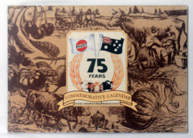
calendar, Pivot Limited, 1994
PIVOT is a company involved in agricultural fertilisers.This is a useful pictorial reference tool.A commemorative calendar with colourful photographs, one for each month. On the front cover are brown drawings of agricultural items and scenes. "Commemorative Calendar" is in a banner above "Pivot Promotions Productivity". above the banner is a sheaf of wheat around "75 YEARS" with two flags - one the Australian flag and the other a PIVOT flag.calendar-pivot -
 Orbost & District Historical Society
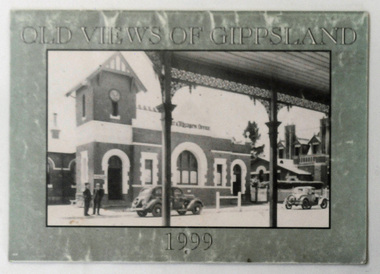
calendar, Old Views of Gippsland 1990, 1998
This is a useful pictorial reference tool.A 1999 stapled calendar, titled "Old Views of Gippsland".On the olive green coloured front is a black/white photograph of 1950's Bairnsdale Post & Telegraph Offiice. It contains early photographs of East Gippsland, one for each month. There is a hole for hanging. calendar-old-views-of-gippsland photographs-historic-gippsland -
 Orbost & District Historical Society
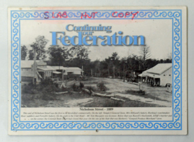
calendar, Snowy River Mail, Continuing Our Federation, 2001
This item was used in the Slab Hut (Orbost Visitor Information Centre).This item is a useful pictorial reference tool on the history of Orbost.A 2002 stapled calendar, titled "Continuing Our Federation".On the front is a black/white photograph of the main street of Orbost. It has blue print and an ornate blue frame. It contains photographs of earl Orbost, one for each month. on front cover -"SLAB HUT COPY" in red felt tip pen.calendar-continuing -our-federation photographs-historic-orbost -
 Orbost & District Historical Society
postcard, C1920-1940
This photograph shows the second major bridge across the Snowy River at Orbost. The current Snowy River bridge is the fourth to provide a crossing to the township of Orbost. The first, in 1891, lasted just two years before it succumbed to flood waters. The bridge in this photograph was built in the 1920s as a road and rail bridge, and was again partly washed away by flood waters in 1934. After the end of the first World War the Victorian Railways considered an extension of the railhead across the river at Orbost, and in 1922 a new timber and steel girder structure, a joint Country Roads Board — Victorian Railways venture, was built and completed at a cost of £41,000 (the steel girders came from the Flinders Street viaduct reconstruction). Subsequently it was decided not to take the railway across the river, and the bridge was only used by road traffic. It was severely battered by floods during its life. and after the 1971 floods was eventually replaced by the current bridge in 1975. (info from Newletter 54N by John Phillips) This item is an early pictorial record of the previous Snowy River bridge at Orbost.A postcard with a black / white photograph of a bridge - timber and steel girder structure - across the Snowy River at Orbost, Reflections of the bridge are seen in the water.snowy-river-bridge-orbost -
 Orbost & District Historical Society
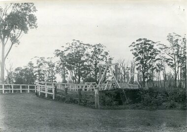
black and white photograph, August 1897
This is a photograph of the bridge from the Orbost side. The first pile bridge over the Snowy River was just completed by Mr Jim Granter when the 1891 flood took out the centre,. There were differences of opinion as to whether the council should pay . The Shire Secretary, Mr John Draffin, persuaded them to honour their obligations. Mr Granter and Mr Clarke finished it as a suspension bridge which was opened by Mrs William Watt. Soon after a mob of cattle stampeded, the weight snapped the cable, letting one side sag. Mr R.P. Cameron repaired it and this bridge remained until 1922. "In 1890 the contract for a bridge was let to Mr James Granter for £1450. This structure with additions and improvements made to it was to cost the ratepayers about £2,500, and its erection was proceeded with in a very satisfactory manner until, just as the greater-part of the work had been completed, the flood of 1891 came down on it, piling up mountains of logs, timber and debris against the piers, which had not been made wide enough apart to allow for. contingencies of this kind. The structure held out bravely until the turn of the flood and then gave way with a crash, about five bays from the centre disappearing in the stream." ( Snowy River Mail August 12 1893) This item is a pictorial record of one of the first bridges across the Snowy River in Orbost.A black / white photograph of the old wooden suspension bridge over the Snowy River. There are two copies 919.1 and 919.2. There are two other photos showing the whole bridge taken from further back.on back - "Orbost Bridge...."snowy-river-bridge-orbost granter-james -
 Orbost & District Historical Society
black and white photograph, Empire Post Cards, C 1940s
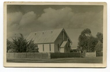
"The first Presbyterian Church service was conducted at the Orbost Station Homestead in 1885, during a visit by Sir William Clarke, who was accompanied by two ministers. The organist was resident Grace Jennings Carmichael. Services were later held in Mr J. W. Borland’s shop and the Mechanics Hall. In 1887, the land on which the church now stands was purchased from Mr James Hossack snr, for £50 ($100). The trustees were Mr John, Peter and Hugh Cameron, Mr John A Watt and Mr James Hossack Jnr. Timber from Richardson’s Tabbara Mill was used by builder Mr R. P. Cameron and at a cost of £311.3.7 ($622) the church was opened January 9th 1898." (from Newsletter 90 Margaret Smith) In 1928 the Sunday School hall was added to the church. Mr R.P. Cameron was the contractor for both the manse and the church. The first communion service was held on July 17 1892. the Presbyterian Church was commenced in Orbost in 1855 when the Reverend Chas Attwood was settled in pastoral charge.This is a pictorial record of the Presbyterian Church in Orbost as it was in the mid 20th century. It is now the Orbost Uniting Church hall, known as St Andrews Hall,A black /white postcard photograph of the Orbost Presbyterian Church, a wooden structure with a wooden picket fence at the front and trees on right and left sides. on back - " H Gap, Presbyterian Church Orbost"presbyterian-church-orbost religion -
 Orbost & District Historical Society
black and white photograph, 1890's
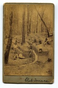
This item was found in the collection with no information recorded. On the back is a short message wishing a happy Christmas to Bessie and Jack from M.W. The photograph shows miners at Club Terrace.This item is a pictorial record of the gold mining history of East Gippsland.A yellowed black / white photograph on grey buff card. It is of men panning for gold and digging trenches.on front - " Club Terrace" on back - " To Bessie, Jack from M.W."club-terrace gold-mining gold-panning gold -
 Orbost & District Historical Society
black and white photograph, 1897
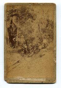
The photo shows miners looking for gold at Dead Horse Creek at Club Terrace. The subjects are unknown.This is a pictorial record of gold mining in East Gippsland in the late 19th century.A yellowed black / white photograph on grey buff card. It is of seven men in the bush mining for gold.on back - "Dead Horse Creek - Club Terrace, 1897"gold-mining gold-panning-club-terrace dead-horse-creek-gold -
 Orbost & District Historical Society
black and white photograph, C 1920s
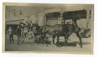
The photograph shows the coach owned by Mr Tom Malinn of Sardine Creek. It is in front of the Orbost Club Hotel in Nicholson Street, Orbost. On lst Juy 1926, Tom Malin took over the horse drawn coach run from Orbost to Delegate. After a few years he obtained an International 2-3 ton truck. On his first trip to Bendoc he did not carry mail, but brought Miss Cunning, the first lady head teacher and collected ballot boxes. On his next trip (March 1930) he made history as the first mailman on this route to deliver mail in a motor vehicle. (info. Bendoc History) Tom and Sophie Malinn farmed at Martin’s Creek. Sophie (nee Jensen) married Tom Malinn in 1926. Sophie’s family had run the historic “Danebo Hotel” at Martin’s Creek for many years, and in 1931, Tom and Sophie began farming at Martin’s Creek, initially cropping maize and beans. The first hotel built in Orbost was the Club in 1885, an old wooden place on the corner built for J. A. Petersen of the Mitchell Hotel Bairnsdale, now known as the Victoria Hotel. Tom Maguire, a stepson of the late Mr. Petersen, carried on the club Hotel Orbost for 5 or 6 years. The property then came into the possession of Alfred Cooper, a Yorkshireman who purchased the freehold about 1890, pulled the building down and erected the present structure.This is a pictorial history horse-drawn transport used widely in Orbost until the late 1920sA black / white photograph of a horse-drawn buggy with four men on the buggy and two mmen standing beside it, It is in front of the Orbost Club Hotel in Nicholson Street, Orbost..on back - "Tom Malinn on coach run"malinn-tom club-hotel-orbost transport-orbost -
 Orbost & District Historical Society
black and white photograph, first half 20th century
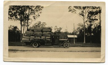
The photograph shows a loaded truck outside the Noorinbee Store. This is a pictorial record of early road transport in East Gippsland.A black / white photograph of a large truck loaded with large bundles. It is in front of a small store at Noorinbee on the main road.on back - "in front of Noorinbee Store"transport noorinbee -
 Orbost & District Historical Society
black and white photograph, 1939
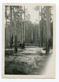
Buldah School was No. 4555. Mrs L. Petterson made application for a school at Buldah during 1936. It was opened on 8th of August 1937 by Herbert H. Eynstone acting as Head Teacher. He held this position for only about two weeks. The school closed during 1941. The Petterson brothers were early settlers in Cann River - late 19th century. This is a pictorial record of a school route in the first half of the 20th century. The Buldah School no longer exists.A black / white photograph of a bush track in a forest. There is water running across the track.on back - Don. by Mrs D. Petterson, only track to Buldah School in winter 1939...."buldah-east-gippsland -
 Orbost & District Historical Society
black and white photograph, C1915
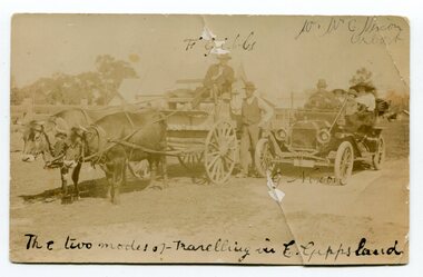
The photograph shows two modes of transport in the early 1900s. Mr F. Gibbs is driving the bullock team and Mr G. Nixon and his family are in the car.This is a pictorial record of transport in Orbost in the early 20th century.A black / white photograph post card showing a bullock team and a motor car.on front at top - " F Gibbs; W.W. G. Nixon, Orbost." on front at bottom - "The two modes of travelling in East Gippsland" on back is a letter from "Jack & Nell to "Alice" transport bullock-team nixon-george -
 Orbost & District Historical Society
black and white photograph, C1900
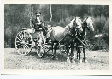
Harry Ingram delivered milk, bread, groceries and meat to towns between Delegate and Orbost with his eldest son. The pair generally drove a four wheeled wagon pulled by five horses along a hand carved winding track through the mountains. This is a pictorial record of transport in the early 20th century in Orbost. It is associated with the Ingram family settlers in Orbost from 1938.A black / white photograph of a man on a horse drawn cart.on back - "Harry Ingram"ingram-harry transport-c19th -
 Orbost & District Historical Society
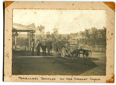
black and white photograph, C 1890s
The photograph shows the Royal Mail wagon outside Herbert's General Store in the main street of Orbost. Lancelot Herbert came to Orbost in 1886, taking up a partnership with local store-owner George Temple. After Mr Temple’s death in 1891, Lancelot took over the store and progressively developed Herberts Snowy River Stores which grew into a department store of several shops along Nicholson StThis is a pictorial record of transport in 19th century Orbost. It is associated with the Herbert family.A black / white photograph of a travelling salesman and his samples on the Orbost Coach outside Herbert's grocery store. Two other men are standing nearby. The photograph is on a cream buff card.on front - "Traveller's Samples on Orbost Coach"herbert's-store transport -
 Orbost & District Historical Society
black and white photograph, 1913
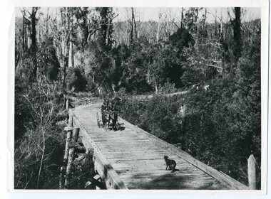
This photograph is of the low level bridge across the Bemm River about 50 km east of Orbost in East Gippsland.This is a pictorial record of the 1913 low level bridge across the Bemm River, East Gippsland.A large black / white photograph of a horse - drawn wagon on the low level Bemm River bridge. In the foreground on the bridge is a dog.on back - "Country Roads Board Princes Highway low level bridge" -
 Orbost & District Historical Society
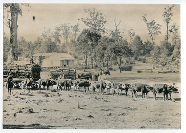
black and white photograph, 1889
This photograph shows a large bullock team at the foot (eastern side?) of the Orbost township.This is a pictorial record of transport used in the late 19th century in Orbost.A large black / white photograph of a bullock team pulling a laden cart. A man is sitting on top of the freight. In the background is a horse - drawn cart loaded with sacks (maize?) with a man on a horse to the side and another standing on the shafts. In the foreground are two men on horses. There is a small house and barn in the background.on back - " At the foot of the township - 1889"orbost transport-bullock-teams horse-drawn-transport -
 Orbost & District Historical Society
black and white photograph, 1913
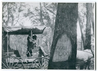
When marking a boundary for a registered plan, a surveyor would place “Reference Marks” with a stated bearing and distance to a boundary corner. These trees were typically marked by cutting the bark of the tree in a shield or blaze. Until July 1886, surveyors were only able to use trees as reference marks to boundary corners. After July 1886 surveyors were able to use “permanent marks” which were either a glass bottle, gas pipe or iron bolt (for homestead surveys only). This photograph shows the reference tree, 83 miles from Marlo via the original surveyed road v ia Sydenham Inlet and Tamboon, south of Mount Drummer to the New South Wales border - now the Princes Highway.This is a pictorial record of an old survet tree. Knowledge of their location, abundance and condition not only provide important insights to past survey practice, but also provide a lasting legacy of a regions land-use history. Old survey trees serve as one of the few remaining physical legacies of early European land settlement history.A large black / white photograph of a horse and buggy pulled up alongside a reference tree which has notches and markings of Roman numerals.on back - " Refernce tree 83 miles from Marlo........to N.S.W. Border"survey-tree reference-tree -
 Orbost & District Historical Society
black and white photograph, 1913
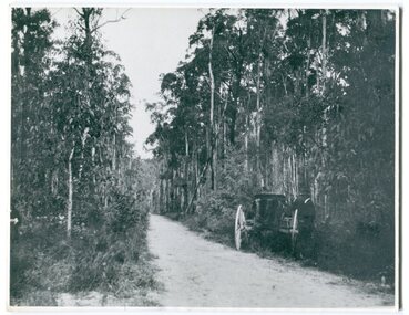
This photograph shows the regrowth of vegetation on the road between Genoa and the border - now the Princes Highway.This is a pictorial record of the main road from Orbost to the New South border, The Princes Highway, in the early 20th century.A large black / white photograph of a bush road wwith a vehicle and a man on the side of it.on back - " Princes Highway showing the regrowth.....1913"princes-highway-genoa transport -
 Orbost & District Historical Society
black and white photograph, late 19th - early 20th century?
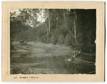
Bunga Creek is approximately 5km east of Lakes Entrance.This is a pictorial record of horse-drawn transport of the late 19th century used in East Gippsland.A black / white photograph of a bush scene with a horse - drawn coach running along a track beside a creek.. It is on a cream coloured buff card.on back - "No. 5" on front - "At Bunga Creek"bunga-creek horse-drawn-coach -
 Orbost & District Historical Society
photograph / postcard, early 20th century
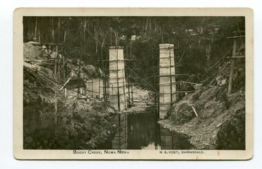
Boggy Creek Bridge was built in 1916 as part of the Bairnsdale to Orbost extension to the main Gippsland Railway, and is situated in the middle of the township of Nowa Nowa, crossing a steep-sided and well-timbered creek-valley. This section of the line closed in 1987.This item is a pictorial record of the construction of the Boggy Creek railway bridge on the East Gippsland line. This bridge plays a major part in the identity and history of the town of Nowa Nowa, since Boggy Creek’s steep sided valley divides the township into two components. A black / white photograph on a postcard showing the construction of a railway bridge across a creek. The end pylons are evident and there is scaffolding on both sides of the creek. Two copies of a black / white photograph showing the construction of a railway bridge across a cree. The end pylons are evident and there is scaffolding on both sides of the creek. There is a steam train on the rail track.on front of postcard - caption - " Boggy Creek, Nowa Nowa, W.S. Vogt, Bairnsdale"boggy-creek-bridge vogt-w.s. railway-bridges east-gippsland-railway railway-construction train -
 Orbost & District Historical Society
black and white photograph, late 19th - early 20th century
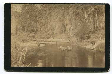
In the late 1800's early 1900's transporting goods by road was difficult and at times impossible because roads as thoroughfares did not exist.The means of travelling along the roads in the 1800's was by bullock wagon, horse pulled dray, pack horse or simply by foot. This is a pictorial record of transport in the mid 18th - early 19th century. Pack horses were vital for the delivery of goods, responding to emergencies as they could travel in country inaccessible to larger horse - drawn carts or wagons.A black / white photograph on a black buff card. It is of a group of pack horses being guided across a waterway with a man on horseback on either side of the river.transport pack-horses -
 Orbost & District Historical Society
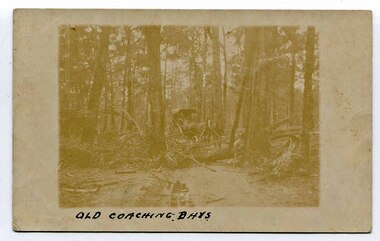
black and white photograph, late 19th - early 20th century
This is a pictorial record of horse-drawn transport in East Gippsland in the late 19th - early 20th century. It depicts the difficulties of transport in the under-developed forests of East Gippsland.A very faded photograph of horses and coach making their way through a bush track obstructed by fallen trees.on front - " Old Coaching Days" on back - ' A. Coulton"transport-horse-drawn -
 Orbost & District Historical Society
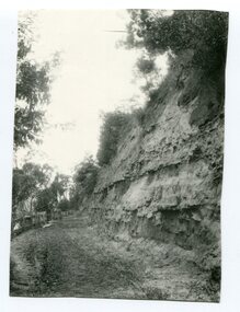
Photograph - Hofen's cutting, Bete Bolong, Orbost district, early 20th century
This photograph is of a cutting on a road at Bete Bolong known as Hofen's Cutting. This photograph was taken c. 1906 when transport was by horse, wagon and prior to cars and railways.This is a pictorial record of early Bete Bolong showing a road through a cutting which was known as Hofen's cutting. Two black / white photographs showing a dirt road heading down a cutting with a post and rail wooden fence on the left side in the background. In 958.1 there is a cut - away hillside beside the dirt road.on back - "Newmerella" (note: this location is at Bete Bolong and not on Newmerella Hill) 958.1 - on back - "Hofen's Bluff 1906"bete bolong, orbost, tracks/roads -
 Orbost & District Historical Society
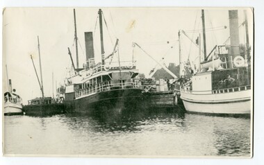
black and white photograph, before 1924
This photograph shows the Lady Harriett, her barge, the Wyrallah and Storm Bird with Captain Jimmy Bills at Harbeck's wharf, Lakes Entrance, The Lady Harriett was a small steamer that serviced the Tambo River and other areas. In 1895 the Lady Harriett was advertised to run between Bairnsdale and Mallacoota on a weekly service. The Lady Harriett and barge did two or three trips up the Tambo per week. She did not carry passengers or run to a timetable and would carry maize and beans as well as fish from Mallacoota where by 1900 the fishing industry was well established' Lady Harriett towed her barge carrying an assortment of goods up the Tambo from 1895 to 1913. The S.S. Wyrallah was a regular Melbourne header for over twenty years. She was run down and sunk by the steamer Dilkera with the loss of six lives at Port Philip Head. (ref. The Argus Friday April 11 1924)This is a pictorial record of a once busy wharf. From Lakes Entrance ocean-going vessels had access to the Gippsland Lakes, the largest navigable inland waterway in Australia.A large black / white photograph of two large ships and two smaller ones at a wharf. There are people on the wharf and on the boats.on back - "Jo-Bull", L-R Lady Harriet.........."lady-harriett s.s.-wyrallah shipping-east-gippsland harbeck's-wharf-lakes-entrance sea-transport -
 Orbost & District Historical Society
framed black and white photograph, C1900
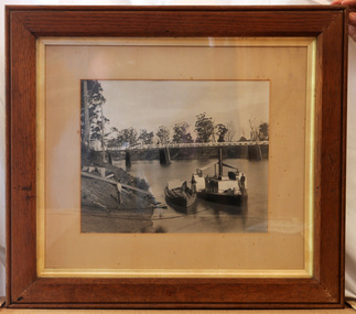
The P.S. Curlip was built by Samuel Richardson & Sons at a Tabbara sawmill in 1889. Alan Richardson, shown in the photograph, was the captain. It was operated along the Snowy River in Australia's Gippsland region between 1890 and 1919, before being washed out to sea, and broken on Marlo beach, by a flash flood in 1919. James Winchester was born in Geelong in 1856. He first sailed into Marlo, aged 15 and returned in the 1870's. he worked on the snagging punt on the Snowy River and also on the Paddle Steamer Curlip which towed the barges to collect the maize grown along the Snowy River. Wooden chutes were constructed along the river banks to load bagged maize onto the barges. The bags of maize were sent down the chutes into the waiting barges. This is a pictorial record of the iconic Paddle Steamer Curlip which has a significant association with Orbost. It records the method of loading maize onto barges through a wooden cchute.A large framed black / white photograph of the Paddle Steamer Curlip and a barge on a river. The barge is being loaded with maize through a large chute. In the background is the Snowy River bridge. the frame is wood. There is also a copy.on back of copy - " Jim Winchester, Alan & Frank Richardson, Curlip - barge & chute for loading maize"p.s.-curlip transport-shipping richardson winchester-james snowy-river maize-loading -
 Orbost & District Historical Society
black and white photograph
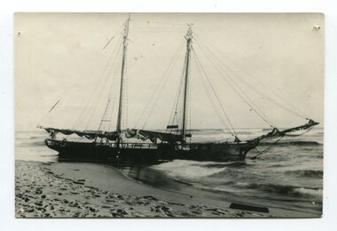
The “Glengarry” beached at Marlo The schooner Glengarry was a well-known trader on the Gippsland coast and had been stranded on a number of previous occasions including at the Natural Entrance joining the Gippsland Lakes to Bass Strait – Ninety Mile Beach, Lakes Entrance, c 1877 . In May 1898, the vessel struck a submerged object while crossing the Snowy River bar at Marlo and was beached, eventually becoming a total loss. Until t he railway came to East Gippsland goods were shipped from Marlo to Melbourne. This is a pictorial record of a well-known trading ship involved in that river transport.Three copies of a black / white photograph of the Schooner Glengarry wrecked in 1891 at the Snowy River entrance at Marlo.schooner-glengarry shipping transport-orbost -
 Orbost & District Historical Society
black and white photograph, before 1912
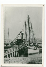
This photo shows the Storm Bird at the end of the jetty and the Wangrabelle in the foreground. Both ships were well known traders. the Wangrabelle became beached and wrecked in 1916 and the Storm Bird became obsolete when the railway from Bairnsdale to Orbost arrived in 1916. (ref. Story of Gippsland Shipping - J.C. Bull) At the start of the river trade goods were shipped from Marlo to Melbourne but when the railway reached Bairnsdale this became unprofitable and the ships plied only between Marlo and Cunninghame. Eventually river transport became economically unviable. The Wongrabelle is still buried in the sands of the entrance of the Snowy River (albeit where the entrance used to be). It took from April 11th 1912 to August 12th 1912 for the loss of the Wongrabelle to be complete, the final entry in the Orbost Shipping Co. records reads:- "The Wongrabelle is completely covered in sand." (ref River, Road, Railway Newsletter O.D.H.S.) This is a pictorial record of a time when the water highways were the only feasible transport mode in sending goods from Orbost and Marlo to Melbourne.A black / white photograph of a ship, sails down, anchored at the Marlo jetty.on back - "M. Gilbert, Wangrabelle at Marlo"storm-bird wangrabelle shipping transport- marlo -
 Orbost & District Historical Society
black and white photograph, C1900
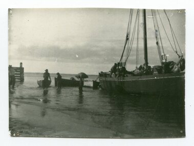
The photograph shows men unloading goods, including a sack, from a ketch moored at Marlo. Marlo was once a very busy port. Goods needed by the early settlers were carted by sea-going vessels to Marlo. At the Marlo wharf goods were unloaded from the large vessels onto barges and towed by paddle steamers to Orbost. (information - In Times Gone By - Deborah Hall)This is a pictorial record of shipping at Marlo.A black / white photograph of men unloading goods from a ketch into small boats. on back - "ketches being loaded at Marlo"marlo-transport marlo-jetty shipping -
 Orbost & District Historical Society
photograph, December 1892
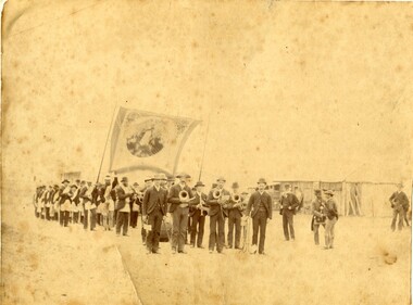
The photograph shows the Delegate Lodge with the Orbost Brass Band at Christmas 1892. They travelled by horseback to play for the Star of Delegate Order of Oddfellows. The first Orbost Brass Band was formed in 1889. Around 1908 the town band split and the Orbost Workers' Band was formed. Eventually the two bands merged in 1913 to reform as the Orbost Municipal Band under conductorship of Charles Spink. The band continued for many years but was later disbanded and again reformed. This was to happen a number of times, the last time being in 1961 and continuing through to the late 1970's. Further info and Ref: In Times Gone By - Deborah HallThis is a pictorial record of the Orbost Brass Band. The various Orbost bands over the years played a major role in community activities providing entertainment and musical experiences for the many members.A very yellowed photograph of a band procession with the men holding their instruments. Two men are holding a large banner. In the background are wooden cabins. The photograph is on a white buff card. There are four copies of this photograph.on back - handwritten - "Presented to Mr C Spink Bandmaster Orbost Brass Band by the members of the Star of Delegate Lodge MUIOOF P Crawford Secretary"orbost-brass-band spink-charles delegate-oddfellows -
 Orbost & District Historical Society
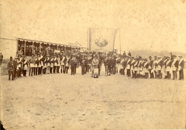
Photograph, December 1892
The Commercial Hotel is now the Delegate Hotel (after 1927). This photograph of the Orbost Brass Band and the Delegate Lodge of UIOOF was presented to the bandmaster by the secretary of the Lodge when the Orbost band went to Delegate to entertain them. They travelled by horseback to play for the Star of Delegate Order of Oddfellows. The first Orbost Brass Band was formed in 1889. Around 1908 the town band split and the Orbost Workers' Band was formed. Eventually the two bands merged in 1913 to reform as the Orbost Municipal Band under conductorship of Charles Spink. The band continued for many years but was later disbanded and again reformed. This was to happen a number of times, the last time being in 1961 and continuing through to the late 1970's. Further info and Ref: In Times Gone By - Deborah Hall This is a pictorial record of the Orbost Brass Band. The various Orbost bands over the years played a major role in community activities providing entertainment and musical experiences for the many members.A yellowed photograph on a white buff card with band members and their instruments. They are standing underneath a large sign with lodge members, wearing Lodge regalia, in a line on each side. In the background is the verandah of a hotel - The Commercial.on back - "Presented to Mr C. Spink, bandmaster Orbost Brass Band, by the members of the ??? Delegate Lodge of IOOF"orbost brass band, orbost workers'band, ioof, independent order of odd fellows, charles spink, 1892