Showing 657 items matching "plenty river greensborough"
-
 Greensborough Historical Society
Photographs, Greensborough Views, 1900c
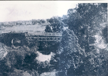
Various views of Greensborough & district in the early 1900's.Records the houses, roads and bridge in Greensborough.2 copies of early Greensborough district photographs.Nilgreensborough, bluestone bridge, main street, aqueduct bridge, plenty river -
 Greensborough Historical Society
Folder, Greensborough and Plenty River Pioneer Trail, 30/10/2011
... Greensborough and Plenty River Pioneer Trail... society plenty river pioneer trail noel withers greensborough ...Trail notes from the Greensborough Historical Society Heritage Weekend Walk, Sunday 30th October 2011. Contains illustrations and information on historical sites within easy walk of Greensborough central.20-page plastic binder, spiral bound, clear cover. Contains trail notes. 6 pages, illus.Collected by Greensborough Historical Society. Folder commenced 2012.greensborough historical society, plenty river pioneer trail, noel withers, greensborough -
 Greensborough Historical Society
Folder, 'Batman' Apple Tree, 1839o
... of the Plenty River in Greensborough circa 1841, by Mr Flintoff. batman ...A collection of documents relating to the Batman apple tree and those men associated with it: Martin Batey, Frederick N. Flintoff and Johannes Adam Bosch.Documents relating to possibly the oldest apple tree in Victoria. The tree was allegedly transplanted from John Batman's orchard in Melbourne to the banks of the Plenty River in Greensborough circa 1841, by Mr Flintoff.20-page plastic binder, spiral bound, clear cover. Contains documents relating to the 'Batman' Apple Tree in GreensboroughCollected by Greensborough Historical Society. Folder commenced 2012.batman apple tree, greensborough, martin batey, frederick flintoff, johannes bosch -
 Greensborough Historical Society
Folder, Lower Plenty River Heritage Walk 2011, 01/05/2011
Contains information about the sites visited on the Heritage Walk 2011 through Yallambie and Viewbank. Notes compiled by Anne Paul with assistance from Russell Yeoman.20-page plastic binder, redcover. Contains 12 page guide.plenty river, heritage trail, anne paul, greensborough historical society, yallambie, viewbank, russell yeoman -
 Greensborough Historical Society
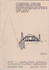
Book, Heidelberg Conservation Study: Part 1 Historic Buildings and Areas Assessment, 1985_
Report prepared by Graeme Butler on behalf of City of Heidelberg and Heidelberg Heritage Advisory Committee. Area covered is from Eaglemont in the south to Macleod in the north.This study identifies neighbourhood character, documents past development and the capacity of the environment for future development.Part one of set of three books. Paperback, 189 pages, Illus., maps. 2 copies.Stamps: Yarra Plenty Regional Library Service, and, Withdrawnheidelberg, macleod, heidelberg heritage advisory committee, graeme butler, plenty river, eaglemont -
 Greensborough Historical Society
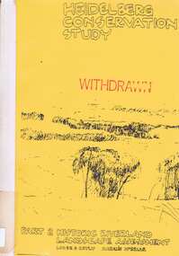
Book, Heidelberg Conservation Study: Part 2: Historic Riverland Landscape Assessment. Revised 1987, 1987_
Report prepared by Loder and Bayly and Marilyn McBriar on behalf of City of Heidelberg and Heidelberg Heritage Advisory Committee. Area covered is from Darebin Parklands in the south to Plenty River at Yallambie in the north. Revised 1987.This study identifies neighbourhood character, documents past development and the capacity of the environment for future development with particular emphasis on the river precincts - Plenty River, Yarra River and Darebin Creek.Part three of set of three books. Paperback, 333 pages, Illus., maps. 2 copies.Stamps: Yarra Plenty Regional Library Service, and, Withdrawnheidelberg, macleod, heidelberg heritage advisory committee, marilyn mcbriar, plenty river, yarra river, darebin creek -
 Greensborough Historical Society
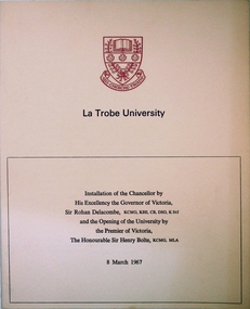
Program, La Trobe University: Installation of Chancellor and opening of the University 1967, 08/03/1967
Installation of Chancellor Sir Archibald Glenn at La Trobe University by Sir Rohan Delacombe, Governor of Victoria. Official opening of La Trobe University in Bundoora on 8th March 1967 by Premier Sir Henry Bolte. Contains background on the development of the university.Celebration of the establishment of the Third University of Victoria. Named after after Charles Joseph La Trobe, Victorias first Lieutenant Governor. It will grow to serve Victoria's North Western Community. The Setting is River Red Gums and grass lands which will be be maintained throughout.Manila coloured card folder with red coloured coat of arms of La Trobe University on cover. Development Plan of university on back cover. (3 copies)la trobe university, bundoora, archibald glenn. -
 Greensborough Historical Society
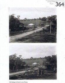
Photograph (copy), Old Bridge and Hotel Lower Plenty, 1925c
2 historical views of the Lower Plenty bridge and hotel. Original photographs are in the Victorian State Library collection.Both the bridge and hotel remain but are in a very different landscape. This shows the area about 110 years ago.A4 photocopy of 2 black and white photographslower plenty, lower plenty hotel, plenty river, lower plenty river bridge. -
 Greensborough Historical Society
Document, Formation of the Heidelberg School of Painting, 1885-1890
The Heidelberg School of Painting worked in the Yarra Valley area between Box Hill and Heidelberg in the late 19th Century and produced a number of famous artists. This article outlines the history of the School and also lists some paintings.The area in which they worked abuts our area of interest and may have overlapped it in the lower Plenty River area.Foolscap double sided typed document of 6 pages; includes list of paintings..Blue biro word on front page, "Fraser"heidelberg, yarra river, walter withers, heidelberg school of painting, australian art. -
 Greensborough Historical Society
Folder, Chapman family (James Chapman), 1849o
... Greensborough Railway Station and Plenty River before selling... between Greensborough Railway Station and Plenty River before ...History of the origins of this Greensborough family and the family tree of James Chapman (1805-1875) and Susan Palmer (1808-1895). James Chapman, his wife Susan and all his family including his son-in-law William Poulter left the Port of London in November 1848 on board the 'Francis Ridley' of 536 tons on her maiden voyage to Australia and Bombay India. The Master of the ship was Henry Hudson. James Poulter owned the land between Greensborough Railway Station and Plenty River before selling it to William Poulter.20-page plastic binder, spiral bound, clear cover. Contains documents relating to the James Chapman family.chapman family, james chapman, susan palmer -
 Greensborough Historical Society
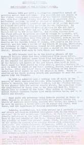
Medicine Kit, Home medicine kit (20th Century), 1937c
Gathered from various donors, these items were in common use throughout the 20th century as home remedies. Rawleigh's Anti-Pain was advertised in The Hillston Spectator and Lachlan River Advertiser (NSW), Thursday 8 April 1937, page 3.Examples of home first aid.Various bottles and tins, some containing liquid. A glass eye bath.first aid kits, medicines -
 Greensborough Historical Society
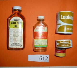
Newspaper Clipping, Diamond Valley Leader, A True Son of The Pioneers: by Linley Hartley, 1982_
Records the Partington family's origins and history in Greensborough through an interview with Alan Partington.Records details of one of the pioneer families of the district.Photocopy of a Leader newspaper story on the Partington family's history in Greensborough.partington family, greensborough, apollo parkways, alan partington, whatmough, plenty river -
 Greensborough Historical Society
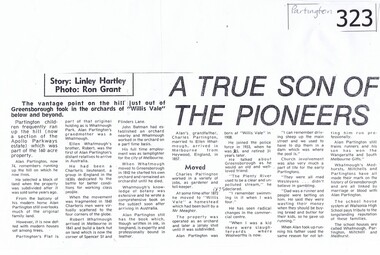
Newspaper clipping, Major Thoroughfare Cuts a Path, 30/3/2011
A half page newspaper article with a photograph of an early Eltham scene recording the origins of Main Road, Eltham. Written by Eltham District Historical Society members Russell Yeoman and Jim Connor.Details some of the deviations that Main Road had taken during its earliest years.A half page newspaper article with a photograph of an early Eltham scene.Hand written date in red pen "30/3/2011".eltham, main road, kangaroo ground, lower plenty, plenty river, montmorency south, old eltham road, bolton street, russell yeoman, jim connor -
 Greensborough Historical Society
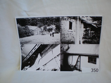
Photograph (copy), Happy Hollow, 13/4/1994
A group of 4 photographs taken in 1994 and an early photograph of the same building for comparison.Happy Hollow farm was located on the Plenty River about 4 km upstream for the Greensborough township. It was originally built in the late 1840's and was rented by the Whatmough family at one time. It is now lost as it was taken over by Parks Victoria, left derelict and burnt down by vandals in the early 2000's.A group of photocopied photographs on A4 size paper. There is a black and wihte copy as well as a colour copy of 4 photographs with transcriptions on the rear of the sheet. The other sheet shows the building in the mid 1800's.Details on the reverse of 2 sheets about the photographs on the obverse.happy hollow farm, bell family, plenty river, whatmough -
 Greensborough Historical Society
Report, Examining Draughtsman's Report - Watts River Aqueduct, 20/07/1897
This Field Survey was commissioned by the Melbourne Board of Works and was used to position the Maroondah Aqueduct bridge north of Greensborough at its crossing point on the Plenty River. It incorporated the use of wrought iron water pipes and therefore is of lighter construction than other similar bridges in the district. It features a traverse of the Plenty RiverThe Maroondah Aqueduct bridge is a significant example of late 19th century engineering. A 4 page reproduction of an Office of Titles document. Copy of handwritten report includes maps.maroondah aqueduct, watts river aqueduct, bridge, greensborough, office of titles, 1897, wrought iron water pipes, plenty river, melbourne board of works -
 Greensborough Historical Society
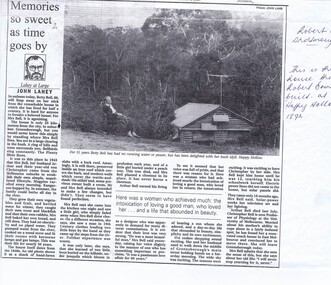
Newspaper clipping, Memories so sweet as time goes by, 24/03/1994
... of Greensborough on the Plenty River. The article informs us that the Bell ...Newspaper article from 1994 recording the history of the Bell family at Happy Hollow.Happy Hollow was built in the late 1840's about 4 km north of Greensborough on the Plenty River. The article informs us that the Bell family moved there in 1943 and lived without power or running water at that site until March 1994 when Betty moved out.A copy of a black and white article from The Age newspaper. Includes text and photograph of Betty Bell at Happy Hollow farm.Biro inscriptions in title and highlighting throuhgout..happy hollow, plenty river, bell family, betty bell, . -
 Eltham District Historical Society Inc
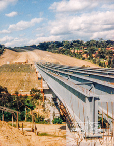
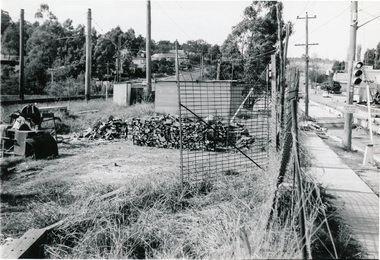
Photograph, Looking east across the new bridge construction across the Plenty River from the western side up to the new roundabout at Civic Drive; Greensborough Bypass construction, c.1986, 1986c
Colour photograph originally located in a magnetic style album titled 'Greensborough Bypass 1990s 5' suffering significant degradation. No information contained in album or on reverse of photos except where noted. Relocated to archival photosafe storage.greensborough bypass, road construction, greensborough, bridge construction -
 Eltham District Historical Society Inc
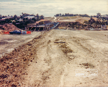
Photograph, Looking west across the new bridge construction across the Plenty River from the eastern side; Greensborough Bypass construction, c.1986, 1986c
Colour photograph originally located in a magnetic style album titled 'Greensborough Bypass 1990s 5' suffering significant degradation. No information contained in album or on reverse of photos except where noted. Relocated to archival photosafe storage.greensborough bypass, road construction, greensborough, bridge construction -
 Eltham District Historical Society Inc
Photograph, Looking east across the new bridge construction across the Plenty River from the western side up to the new roundabout at Civic Drive; Greensborough Bypass construction, c.1986, 1986c
Colour photograph originally located in a magnetic style album titled 'Greensborough Bypass 1990s 5' suffering significant degradation. No information contained in album or on reverse of photos except where noted. Relocated to archival photosafe storage.greensborough bypass, road construction, greensborough, bridge construction -
 Eltham District Historical Society Inc
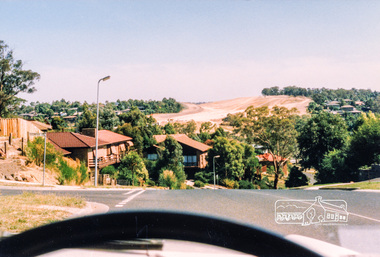
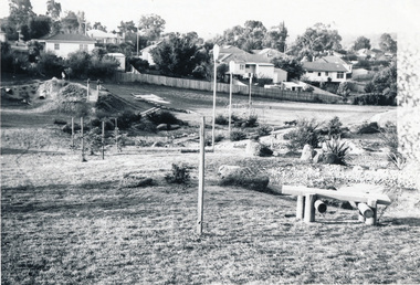
Photograph, Looking west along Plenty River Drive near intersection with Goonyah Court, Greensborough, c.1986, 1986c
... plenty river drive goonyah court Colour photograph originally ...Colour photograph originally located in a magnetic style album titled 'Greensborough Bypass 1990s 5' suffering significant degradation. No information contained in album or on reverse of photos except where noted. Relocated to archival photosafe storage.greensborough bypass, road construction, greensborough, plenty river drive, goonyah court -
 Eltham District Historical Society Inc
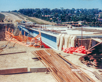
Photograph, Looking west across the new bridge construction across the Plenty River from the eastern side; Greensborough Bypass construction, c.1986, 1986c
Shows the service access road on the hill side which would later be cut away to provide the connection to the Northern Ring Road which was opened in April 1994.Colour photograph originally located in a magnetic style album titled 'Greensborough Bypass 1990s 5' suffering significant degradation. No information contained in album or on reverse of photos except where noted. Relocated to archival photosafe storage.greensborough bypass, road construction, greensborough, northern ring road -
 Eltham District Historical Society Inc
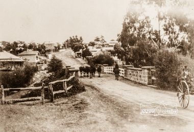
Photograph, Main Street, Greensborough, c.1900, 1900c
... the Plenty River Bridge... the Plenty River Bridge greensborough main street plenty river bridge ...Shows view looking up Main Street, Greensborough across the Plenty River BridgePhotograph copy originally located in a magnetic style album titled 'Greensborough Bypass 1990s 5' suffering significant degradation. No information contained in album or on reverse of photos except where noted. Relocated to archival photosafe storage.greensborough, main street, plenty river bridge -
 Eltham District Historical Society Inc
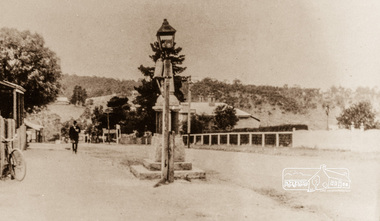
Photograph, Main Street, Greensborough, 1920s, 1920s
Looking towards the Plenty River from outside the current premises of the State Savings Bank. In the foreground is one of the old carbide street lamps. Behind the lamp is the drinking fountain erected as a memorial to Greensborough's Great War (First World War) Diggers. This memorial is now in the park in Henry Street, (Photo: Nillumbik Historical Society)Colour photograph copy originally located in a magnetic style album titled 'Greensborough Bypass 1990s 5' suffering significant degradation. No information contained in album or on reverse of photos except where noted. Relocated to archival photosafe storage.greensborough, main street -
 Eltham District Historical Society Inc
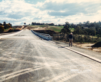
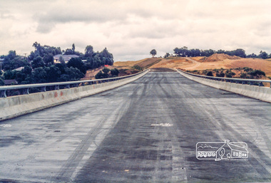
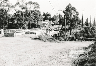
Photograph, Para Road Bridge construction, Briar Hill, near Greensborough, c.1971, 1971c
Three black and white photographs; two showing construction works of the bridge over the Plenty River at Briar Hill and one of Greensborough Park, Grimshaw Street, summer 1971-1972greensborough, briar hill, para road, bridges, construction, plenty river -
 Eltham District Historical Society Inc
Negative - Photograph, Russell Yeoman, Para Road / Carter Street Bridge over the Plenty River, Briar Hill, c.Jul. 1969
Bridge over the Plenty River at Briar Hill before widening and alterations. The Plenty River at Briar Hill represented the boundary between the Shire of Eltham and the Shire of Diamond Valley. The bridge was known as the Carter Street Bridge as prior to 1969 Para Road, Briar Hill became Carter Street, Greensborough across the river. It was at this time that the name Para Road was continued and replaced Carter Street.This photo forms part of a collection of photographs gathered by the Shire of Eltham for their centenary project book,"Pioneers and Painters: 100 years of the Shire of Eltham" by Alan Marshall (1971). The collection of over 500 images is held in partnership between Eltham District Historical Society and Yarra Plenty Regional Library (Eltham Library) and is now formally known as the 'The Shire of Eltham Pioneers Photograph Collection.' It is significant in being the first community sourced collection representing the places and people of the Shire's first one hundred years.Digital image 35 mm B&W negativeshire of eltham pioneers photograph collection, briar hill, 1969-07, bridge, carter street bridge, para road, para road bridge, plenty river, shire of diamond valley, shire of eltham