Showing 1960 items
matching tourists
-
 Lakes Entrance Historical Society
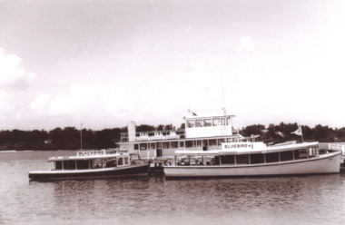
Photograph - Lenna Bird/ Bellbird, Peel family, Peels tourist launches, Cunninghame Arm Lakes Entrance Victoria, late 1960 s
Black and white photograph of Peels tourist launches Lenna Bird and Bluebird moored at jetty in Cunninghame Arm Lakes Entrance Victoria.. Also black and white photograph slightly blurred of Peels launch Bellbird in Cunninghame Arm Lakes Entrancetourism, boats and boating, waterways -
 Lakes Entrance Historical Society
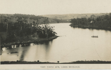
Postcard - North Arm Lakes Entrance Victoria. c1935, 1935 c
Black and white postcard showing a tourist launch on the calm waters of North Arm Lakes Entrance Victoria. c1935 Also two other black and white postcards showing launch and rowing boat on North Arm waterway Lakes Entrance View North Arm Lakes Entranceboats and boating, tourism, gippsland lakes -
 Lakes Entrance Historical Society
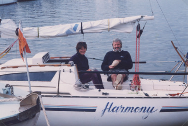
Photograph - Yacht Harmony and Wyanga Winery tourist launch Lakes Entrance 1999
04305.1 10 x 15 cm. 1999Colour photograph of Bill Newcomen and his wife Wendy relaxing aboard their yacht Harmony moored on the Gippsland Lakes Victoria. Also a colour photograph of Wyanga Winery fibreglass tourist launch passing under the North Arm Bridge 1999jetties, waterways -
 Kiewa Valley Historical Society
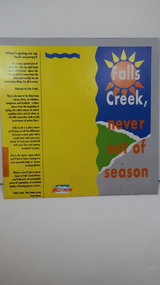
Brochure - Falls Creek Tourism, Falls Creek Never Out of Season
Falls Creek is a Ski Resort in the north east of Victoria. This brochure has been produced to encourage tourists to visit throughout the year.Tourism to the Kiewa Valley is an important industry for the area. Falls Creek is a ski resort with accommodation during winter for skiers, snow boarders and other snow sports. It involves entertainment, restaurants and associated workers. This brochure is produced to promote the resort throughout the year to increase the occupancy of these lodges. The tourist industry has increased steadily with fishing, cycling and bush walking increasing numbers in the area.Glossy square brochure folded in in half and half again. Front page is yellow on the left with black print on the far left. The right side has the title with blue, green and grey background with yellow, orange and white as part of the title. The back is a man standing in front of a sunset with print in a column towards the right side. Inside includes a map with advertisements for accommodation surrounding it.falls creek ski resort; alpine region in victoria; mountain lodges; -
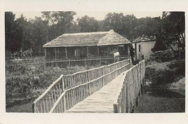 Phillip Island and District Historical Society Inc.
Photograph
One of 23 photographs from the Jessie Smith Collection. Donated by Stan McFee. This is the current Cowes Foreshore Tourist Park 2020Black & White photograph of a Shelter Shed at the Council Camp Beach. A figure of a person standing behind a fence and another person between the two buildings. Trees in the background. Footbridge and garden in the foreground.On back: "Shelter Shed at Council Camp beach - Mr. McKenzie owned it."council camp beach, phillip island, jessie smith collection, stan mcfee, camping, cowes west -
 Federation University Historical Collection
Book, Casey Nelson et al, Hepburn Shire, Daylesford Regional Tourist Signage Review & Strategy 2006 - Prepared by University of Ballarat Students', 2006
Hepburn Shire, Daylesford Regional Tourist Signage Review & Strategy 2006 - Prepared by the University of Ballarat - Applied Management Project - Tourism.White bound book of 57 pages. Includes two hand written oral exams.Alterations, corrections and comments throughout book. Includes 19 Appendices.university of ballarat, mary hollick, hepburn shire council, casey nelson, christine watts, regional signage review, aim, methodology, literature review, visitor survey, discussion, conclusions and recommendations, references, appendices, tylden, trentham, daylesford, dean, creswick, smeaton, clunes -
Federation University Historical Collection
Book, Tourism & Marketing Unit, Ballarat University College, Grampians Tourist Survey - Summary Results January-December, 1991, 1991
Grampians Tourist Survey - Summary Results January-December, 1991. Tourism & Marketing Unit, Ballarat University College, Students' Project.White bound book of 12 pages plus 15 tables and 1 appendix.ballarat university college, grampians, stawell, introduction, methodology, results, conclusion, stawell and grampians economic development association, halls gap, grampians national park, great ocean road, victorian otways, mckenzie falls, wonderland forest, brambuk cultural centre, grampians/gariwerd region -
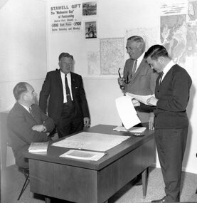
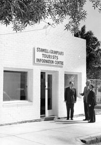 Stawell Historical Society Inc
Photograph, Stawell & Grampians Tourist Information Centre Opening 1968
Stawell & Grampians Tourist Information Centre Opening 1968 Left to Right Ian McCann, Keith Lawson (Mayor), Eric Gilmartin stawell -
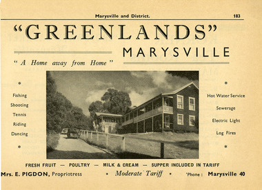 Marysville & District Historical Society
Ephemera (Item) - Information booklet advertisement, Broadbent's Official Road Guides Company, "GREENLANDS" MARYSVILLE, Unknown
An advertisement for Greenlands guest house in Marysville taken from a Broadbent's accommodation guide. Broadbent's was the official guide of the Government Tourist Bureau.An advertisement for Greenlands guest house in Marysville taken from a Broadbent's accommodation guide.marysville, victoria, australia, greenlands, the spot, green lanes, sarah mclean, murdock mclean, geoffrey cobb, cath m anderson, mr and mrs a.g. clarke, e pigdon, bert patterson, guest house, advertisement, broadbent's accommodation guide -
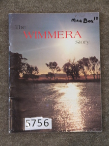 Stawell Historical Society Inc
Book, Regional Information Series, The Wimmera Story, 1983
Tourist information of the Wimmera This book was produced for Wimmera Tourism. Arthur Kuehne did the Stawell Preparations pages 44, 45 & 46Card Cover with colour photo of Natimuk Lake and Mt Arapiles in the background.The Wimmera Story. (in Black and red print.)stawell farming -
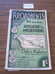 Stawell Historical Society Inc
Book, Broadbent directory, Broadbent's Official : Speedo Strip Road Guide, 1943
Maps and descriptions of towns on the Western Highway & Dukes Highway from Melbourne to Adelaide. Sponsored by R.A.C.V and The Victorian Government Tourist BureauCream paper cover back border with green filling with a map from Melbourne to AdelaideBroadbeants Official Speedo Strip guide Melbourne to Adelaidestawell transport -
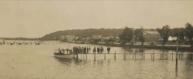 Lakes Entrance Historical Society
Photograph, Tourist Launch, Lakes Entrance - Easter 1928, Easter 1928
They are about to board a tourist launch in front lake. Buildings shown on Esplanade from Federal Hotel to Glenara Lakes Entrance Victoria. Faded black and white photograph showing about two dozen people on jetty . Also a black and white copy township, waterways, tourism, boats and boating, jetties -
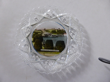 Warrnambool and District Historical Society Inc.
Platter, Transfer Hopkins River
This is a souvenir dish or small plate with an illustration of the Hopkins River in Warrnambool. Included in the illustration are the rowing shed, the boathouses and the lambertiana trees in the property of Lyndoch. The souvenir dish would have been sold to tourists visiting Warrnambool or Warrnambool residents in the 1920s and 30s. This type of souvenir was popular at the time in any tourist town or place in Australia. Tourism has been an important industry in Warrnambool since the late 19th century. This item is of interest as an example of the type of souvenir produced for tourists in the 1920s and 30s. It was both a useful and decorative item. It will be useful for display. This is a small glass souvenir dish. The centre of the dish features a colour illustration of the Hopkins River, Warrnambool (near its mouth). The glass around the illustration is heavily patterned and embossed. The bottom of the dish is dark blue. ‘Hopkins River Warrnambool’ tourism in warrnambool, warrnambool history -
 Kiewa Valley Historical Society
Postcard - Bogong Village x2
Bogong Village became a tourist town after the State Electricity Commission of Victoria sold it upon the completion of the Kiewa Hydro Electric Scheme.Bogong Village was built by the SEC as a town for its employees on the Kiewa Hydro Electric Scheme. This card represents the village in later years when it was being promoted as a holiday resort.Cover: 5 colored photos of Bogong Village with a blank space for writing the address and affixing the postage stamp. Other side is covered with horizontal parallel lines on which to write. Paper is made to fold into three with gum at the top to seal.bogong village, tourism -
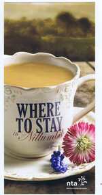 Greensborough Historical Society
Leaflet, Nillumbik Tourist Association, Where to stay in Nillumbik, 17/10/2015
Lists 10 major tourist accommodations in: Bundoora, Diamond Creek, Eltham, Hurstbridge, Kangaroo Ground, Panton Hill, Research, St AndrewsColour, printed both sides, map of area, A4 folded twicenillumbik -
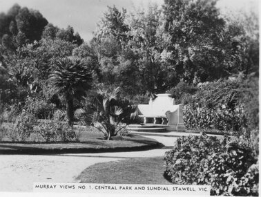 Stawell Historical Society Inc
Photograph, Murray Views, Central Park & Sundial in Stawell c1950 -- Postcard, C. 1950
Sister of Donor visited Stawell in the 1950's when she purchased these Murray Views cards. These cads were produced for sale to touristsSet of 8 Murray Views Postcards No. 1 to 8 C. 1950'sMurray Views No 1 Central Park and Sundial Stawell Victourism postcards -
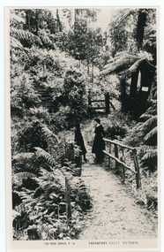 Mt Dandenong & District Historical Society Inc.
Photograph, Sassafras Gully, Victoria, c1920
The tourist track running alongside the creek from Sassafras Mechanics’ Hall to Emerald. In the early 1900s the track started at Rostrevor Guest House.Black and white copy of Rose Series Post card P. 74 showing two young women standing on a footbridge at Sassafras Gully. A set of steep steps can be seen above them.rose series, track, footbridge, bridge, sassafras -
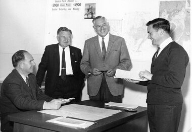 Stawell Historical Society Inc
Photograph, Stawell & Grampians Tourist Information Centre Opening with Mr Ian McCann on the left & Mr Doug Hutton, the Town Clerk on the right 1968
Stawell & Grampians Tourist Information Centre Opening 1968 L to R Ian McCann, Eric Gilmartin, Keith Lawson, Doug Huttonstawell -
 Stawell Historical Society Inc
Photograph, Stawell & Grampians Tourist Information Centre Opening 1968
Stawell & Grampians Tourist Information Centre Opening 1968 L to R Ian McCann, Eric Gilmartin, Keith Lawson, Doug Huttonstawell -
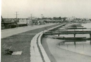 Lakes Entrance Historical Society
Postcard - Lakes Entrance, Bulmer H D, 1940c
From a wallet of minitiature postcards published by Bulmer for sale to tourists. Also enlarged black and white copy 18.5 x 25 cm,Black and white mini postcard of Esplanade, showing timber groynes for sand control at edge of lake at walking path of concrete slabs. Across the highway from left to right is Kia-Ora House, Heyfield House, Coate Bros Garage, Robin Hood Inn, Vizes Cafe, Vic Carstairs, Miss Brown's (subagent for Statebank), Methodist Church, Bellevue Guest House, Police Station, Maranui Guest House, Glenara Guest House. Lakes Entrance Victoriatownship, waterfront, accommodation -
![Booklet, Souvenir of Phillip Island [Cowes, Rhyll, Newhaven etc] and San Remo, Late 1920s. Post 1926](/media/collectors/4f729f5b97f83e0308601629/items/6462d05d551955aaca8bbecf/item-media/6462d125551955aaca8c0867/item-fit-380x285.jpg) Phillip Island and District Historical Society Inc.
Phillip Island and District Historical Society Inc.Booklet, Souvenir of Phillip Island [Cowes, Rhyll, Newhaven etc] and San Remo, Late 1920s. Post 1926
Broadbent's Official Road Guides Company took over George R. Broadbent's business in 1935. In 1963, it changed its name to Broadbent's Road Maps Pty. Ltd. Broadbent's company produced many maps, road and tourism guides of Australia.HistoricalSmall, beige coloured booklet with blue print and round photo of S.S.Alvina at Cowes jetty on cover. Advertisement for Westernport Steamer Service on rear page. Contains descriptions of main towns and places of interest. Also advertisements for guesthouses, businesses and tourist guides.Broadbent's Holiday Guide to Phillip Island and San Remo. [alternative title]tourist brochure, souvenir, broadbent's guides, phillip island accommodation, ferries, maps, guesthouses, hotels, shops -
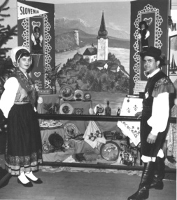 Slovenian Association Melbourne
Slovenians at Royal Melbourne Show 1959, Slovenians in national costumes at the Royal melbourne Show in 1959, 1959
The Slovenians enjoyed participation at the Royal Melbourne Show 1959 where they could showcase the Slovenian traditions, arts and crafts, and at times,culinary goodies as well.Traditional Slovenian crafts, national costume and the tourism jewel Lake BledSlovenian couple dressed in Slovenian national costume of Gorenjska region at the Royal Melbourne Show in 1959. The painting shows the tourist attraction Lake Bled and many traditional items of craft were placed in the exhibition as well. The man in the photo is Leopold Jalk.Couple dressed in Slovenian national costume, painting of Lake Bled and Slovenian traditional craftsslovenian national costume, slovenian crafts, lake bled, royal melbourne show -
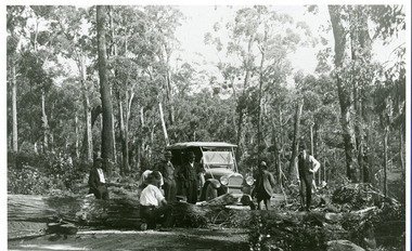 Mt Dandenong & District Historical Society Inc.
Photograph, Car On New Road Blocked By Tree
Site said to be the new Mt. Dandenong Tourist Road a short distance past present Silvandale Store (Kalorama Post Office now). Early model vehicle and passengers delayed by tree across road. Not much progress being made with axe.kalorama, mt. dandenong tourist road, silvandale store -
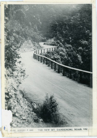 Mt Dandenong & District Historical Society Inc.
Photograph, The New Mt Dandenong Road, Vic
Copy of Rose Series postcard #385 showing the new Mt Dandenong Tourist Road with wooden railing fence on low side of road. Surface not yet made. This photograph has a detailed inscription on the back handwritten by John Lundy-Clarke in 1974.View downhill from the Windy Bend showing the site of the 1972 landslide. In this picture the road is running along the top edge of the wall 900’ thick of Kalorama Docite that plunges thousands of feet deep down into the earth below the Ranges and extends to Fern Tree Gully. It was once a horizontal terrace nearly ten miles square and tipped over to the left when the mountain subsided into its volcanic cauldron.mt dandenong road, rose series, windy bend, landslide -
 Bendigo Historical Society Inc.
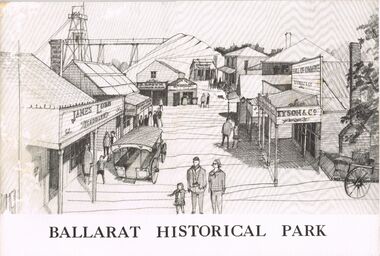
Book - MERLE HALL COLLECTION: BOOKLET: ''BALLARAT HISTORICAL PARK''
Booklet: ''Ballarat Historical Park'' B&W illustrated booklet (''A Presentation of the Project of the Ballarat Historical Park Association'' re Sovereign Hill. - formation of the Association; story of Sovereign Hill; the site and the plan; potential as a tourist centre; committee and consultants listed. -
 Falls Creek Historical Society
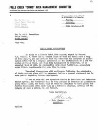
Document - Falls Creek Development - Ski Tow System
Bob Hymans Collection Bob (Herman) Hymans (a former member of the Royal Netherlands Navy) was born in Bloemendaal, Holland on 30th September 1922. During World War II he fought against the Japanese in the Dutch East Indies (now Indonesia) and was imprisoned in Changi and on the Burma Railway. After gaining qualifications as a Ski Instructor, Bob arrived in Falls Creek in July 1950. Working as an Instructor and Supervisor at Bogong Lodge, Bob decided his future was in accommodation. He was successful in negotiating an indenture for land from the State Electricity Commission (SEC). It took Bob two years to build his Grand Coeur Chalet but, tragically, it was burned down in August 1961. Bob also built the first Chairlift in Australia. This was a single chairlift and the structure was built from wooden electricity poles. He was constantly full of new ideas and proposals for the village. Bob Hymans died on 7th July 2007. This Collection of documents and letters tells the story of Bob's endeavours to develop Falls Creek into the ski village it is today.This letter is significant because it reflects the relationship between Bob Hymans and the Management Committee.A letter from the Falls Creek Tourist Area Management Committee to Bob Hymans advising that a proposal for new ski lift from another company has been accepted. It also states that is premature to discuss a intro-tow ticketing system at this stage.falls creek tourist area management committee, ski lift proposals -
 Lakes Entrance Historical Society
Postcard - North Arm bridge Lakes Entrance Victoria, Bulmer H D, 1950c
3 Identical small format postcards 9 x 14Black and white small format postcard showing the town, North Arm bridge, Cunninghame Arm, sand hummocks, boat harbour, tourist launch approaching North Arm, power poles on lower side of road cutting. Lakes Entrance VictoriaLakes Entrance from Jemmys Pointbridges, township -
 Bendigo Historical Society Inc.
Document - CENTRAL NELL GWYNNE MINE - NOTES ON CENTRAL NELL GWYNNE AREA
Typed notes on the description of the Central Nell Gwynne Mine Area and the Victoria Hill Area. Also mentioned are the Victoria Quartz Mine, Lansell's 'big' 180, Ballerstadt, George Lansell, Adventure and the Cinderalla. Also recommendations for tourist purposes. (2 pages)mine, gold, central nell gwynne mine, central nell gwynne mine, victoria hill, victoria quartz mine, new chum line, lansell's 'big' 180, ballerstadt, george lansell, fortuna, a. h.q. survey regiment, adventure, rae, wittscheibe & co., luffsman & sons, lazarus mine, latham & watson's mine, great extended hustlers -
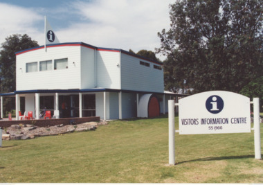 Lakes Entrance Historical Society
Photograph - Stage 2 of Tourist information Centre Lakes Entrance, 1/04/1993 12:00:00 AM
Colour photograph showing stage 2 of the tourist information building with extensions, name change to Visitors Information Centre Lakes Entrance Victoria. Also three colour photographs taken of the information centre soon after the official opening at Lakes Entrancetourism, gippsland lakes -
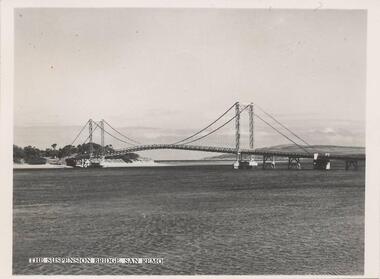 Phillip Island and District Historical Society Inc.
Photograph, 1940's - 1950's
One of a collection of 9 photographs donated by the former Shire of Phillip Island. This photo was part of a pack of postcards sold to the tourists/visitors to Phillip Island.Black & White photograph of view eastward from Cleeland Bight of the Phillip Island/San Remo Suspension Bridge. The photo is part of a set."The Suspension Bridge San Remo"suspension bridge san remo/phillip island, phillip island suspension bridge, bridges, shire of phillip island