Showing 2417 items
matching townships
-
 Whitehorse Historical Society Inc.
Map, Township of Norwich, ca 1850
Plan of the Township of Norwich being subdivision of Section III, Parish of Nunawading, County of Bourke, consisting of suburban farms, vineyard sites and town lots, for sale by auction by W. Casey & Co. [c. 1850]. Original in Vale Maps Collection, La Trobe Library.norwich village, vermont, parish of nunawading, vermont south, maps -
 Bendigo Historical Society Inc.
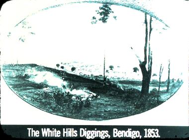
Slide - DIGGERS & MINING: THE DIGGINGS - THE DIGGERS
Diggers & Mining: The Digging - The Diggers. Slide depicts: The White Hills Diggings, Bendigo, 1853. Shows aborigines sitting on near side of hill. Over the hill in the back ground is a small township forming. Markings: 22 994.LIF:6. Used as a teaching aid.hanimounteducation, tertiary, goldfields -
 Bendigo Historical Society Inc.
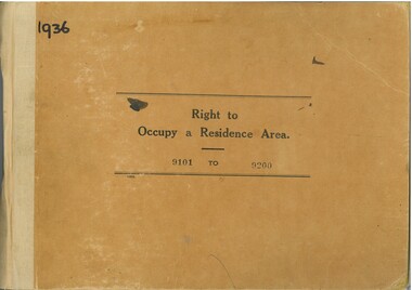
Administrative record - Right to Occupy Certificates, 1936
Twelve books containing stubs of Right to Occupy Certificates for 1936. Includes name and address of person receiving the Right to Occupy certificate and the description of the land including allotment, Section, City, Town, Borough or Township and Parish name. List of record Numbers in Box 906 Some items have pencil and pen marks and ink stains.right to occupy, central victoria -
 Lakes Entrance Regional Historical Society (operating as Lakes Entrance History Centre & Museum)
Photograph - Township, Fish, Marie, 1985c
Colour photograph of part of township showing Jemmys Point, Mount Barkly, Kalimna Heights, North Arm & old North Arm bridge, looking beyond to Rigby Island. Photo taken from near Telecom Tower on Merrangbaur Hill. Lakes Entrance Victoriatopography, township, waterways, bridges -
 Lakes Entrance Regional Historical Society (operating as Lakes Entrance History Centre & Museum)
Postcard - Bullock Island, Bulmer H D, 1920c
Hand coloured postcard of Bullock Island and the man made entrance from Bass Strait to the Gippsland Lakes. Also shown the small township, unofficially known as Carpentertown at the entrance works. Photo taken from Kalimna Hill, shrubbery in foreground. Lakes Entrance VictoriaBullock Island, Lakes Entrancewaterways, bridges, islands, jetties -
 Kiewa Valley Historical Society
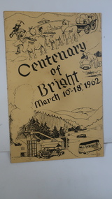
Booklet - Bright, Centenary of Bright March 10th - 18th, 1962
Township of Bright celebrated its centenary during the week from 10th - 18th March, 1962. This booklet outlines the program for the week.Bright is a nearby town to the the Kiewa Valley and currently the location of the current Shire (Alpine). The program gives historical information on activities in the early 1960s.Yellowy/Orange cover with brown title and sketch. One sketch is at the bottom and includes hills, pines, saw mill and bus. Sketch at the top is of a bullock team and in the middle on the right a gold miner. Inside cover has print as has both sides of the 4 pages held by 2 staples. 'C. Roper' on inside of the front cover.bright, centenary of bright -
 Greensborough Historical Society
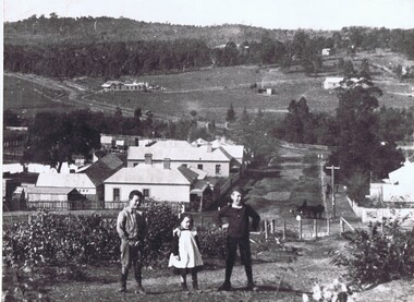
Photograph, Diamond Creek
This undated view of Diamond Creek shows three children on a hill looking over a small township with open fields and trees in background. Large black and white photograph of a view over a town and rural landscape.diamond creek -
 Halls Gap & Grampians Historical Society
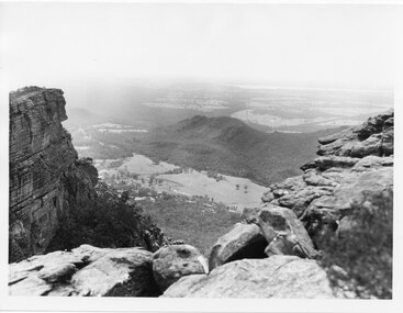
Photograph, C 1960s
The valley is known as Fyans Valley and the township of Halls Gap. Photo is typical of those taken by the Forestry Commission (Vic) during the 1960s.Photo shows two rocky outcrops in the foreground framing a valley in the distance below. A partial view of a mountain range flanks the valley. Plains of trees and open fields, and also a lake, can be seen beyond the mountain range. Within the valley in the middle of the photo buildings, roads and cleared land can be seen.scenery, fyans valley -
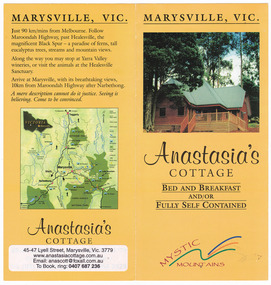
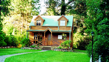
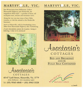
 Marysville & District Historical Society
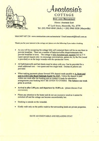
Ephemera (Item) - Reservation form, Anastasia's COTTAGE, Unknown
An information and reservation form for Anastasia's Cottage in Marysville. This cottage, along with most of the buildings in the township, was destroyed in the 2009 Black Saturday bushfires.An information and reservation form for Anastasia's Cottage in Marysville.marysville, victoria, australia, reservation form, accommodation, anastasia's cottage, 2009 black saturday bushfires -
 Clunes Museum
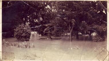
Photograph - PHOTOGRAPH FLOODS 1934
AFTER HEAVY RAINS - CRESWICK CREEK IN CLUNES TOWNSHIP FLOODED, OVER FLOWING ITS BANKS, NEAR BY AREAS WERE SUBMERGED.BLACK AND WHITE SMALL PHOTOGRAPH OF CLUNES FLOODS IN 1934. CLUNES QUEEN'S PARK WITH FOUNTAIN UNDER WATER - TREES IN THE BACKGROUND AND A FEW FLOWERS IN THE FOREGROUND.local history, queen's park garden., floods 1934 -
 Orbost & District Historical Society
black and white photographs, 1974 - 1976
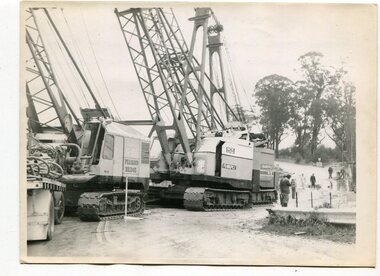
Construction of the roadway embankment between the bridges across the Snowy River flood plains at Orbost commenced in January 1974 and was completed in November 1976. Pearsons were the bridge contractors for the construction of the Princes Freeway and bridges across the river flood plains at Orbost. Heavy rains and floods held up progress.These photographs are of the construction of a major structure in Orbost. The opening of this Snowy River Bridge was an important development in the accessibility to the township of Orbost.Four black / white photographs of construction sites. 3241.1 is of three cranes and other machinery with six persons. 3241.2 is of workmen working on flooded site. 3241.3 is a photograph of the early stages of construction of a bridge looking towards the township. 3241.4 shows the construction of a roadway between the bridges.construction-snowy-river-bridge bridge-orbost -
 Orbost & District Historical Society
black and white photographs, March 10 1961
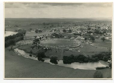
These photographs are pictorial record of Orbost in 1961.They enable us o observe the objects in their spatial context and in detail. They are useful for reference.Four black / white aerial photographs. there are spare copies of each. 3276.1 is an aerial photograph of the Orbost Show with Lochiel Park in the foreground. 3276.2 is an aerial photograph taken over a township. 3276.3 shows the Orbost High School on the left. 3276,4 shows the high school in the foreground.on the back of each is "March 10th 1961 Aerial of Orbost"photographs-aerial-orbost-1961 orbost-1961 lochiel-park -
 National Vietnam Veterans Museum (NVVM)
Photograph, Medcap
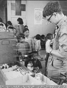
A black and white photograph of a medic attached to 161 (Indep) Recce Flt administers vitamin pills to children during a Medcap conducted at Xuyen Moc after the township had been cleared of VietCong forces by 5 RAR (note text is missing from the bottom of the photograph)photograph, 161 reconnaissance flight, xuyen moc, 5 rar, gibbons collection catalogue, medic, viet cong -
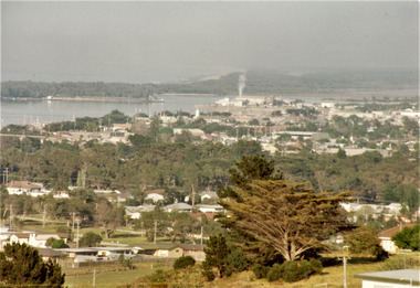
Lakes Entrance Regional Historical Society (operating as Lakes Entrance History Centre & Museum)
Photograph, 1930c
This is the before photograph used in the 150 year Lakes Entrance 1858 - 2008 display.Black and white panoramic photograph showing the township, taken from Allens Hill at the top of Myers Street. It shows the town between Cunninghame Arm and North Arm, on the western side Bernies Point. Allens Hill now known as Butchers Paddock. Lakes Entrance Victoriawaterways, vegetation -
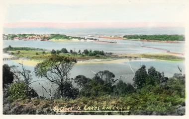
 Lakes Entrance Regional Historical Society (operating as Lakes Entrance History Centre & Museum)
Postcard, Engelander John & Co Pty Ltd, 1980c
Panoramic view of Lakes Entrance taken by Melbourne firm for West Germany A.F.K. International Publishers of world's most famous beauty spotsColour postcard with serrated edge, of the township, situated between Cunninghame Arm and North Arm. Boats moored at jetties and beside boat ramps in North Arm. Photo taken from Kalimna Heights. Dredged sand dumped in North Arm bight. Lakes Entrance VictoriaLakes Entrance, Victoria, Australia (on back)boats and boating, waterways, topography -
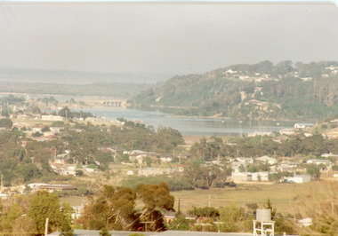
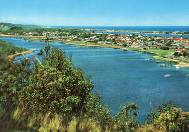
 Lakes Entrance Regional Historical Society (operating as Lakes Entrance History Centre & Museum)
Photograph - Township, Fish Marie, 1985c
Colour photograph of township, showing building on Bullock Island, Cunningham Arm and small white shed on old New Works Jetty near the entrance, view towards the barrier. Photo taken from near telecom tower on Merrangbaur Hill 1985c. Lakes Entrance Victoriatopography, township, waterways, bridges -
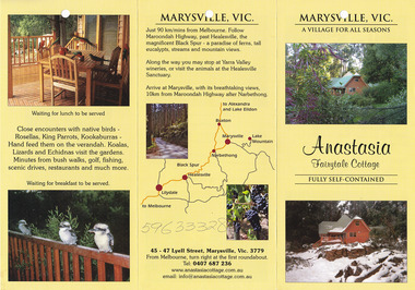
 Marysville & District Historical Society
Ephemera (Item) - Information brochure, Anastasia's COTTAGES, Unknown
An information brochure regarding Anastasia's Cottages in Marysville. These cottages, along with most of the buildings in the township, were destroyed in the 2009 Black Saturday bushfires.An information brochure regarding Anastasia's Cottages in Marysville.marysville, victoria, australia, anastasia's cottages, information brochure, accommodation, 2009 black saturday bushfires -
 Marysville & District Historical Society
Photograph (Item) - Colour photograph, Unknown
A colour photograph of Ashlar Cottage B&B in Marysville. This cottage, along with the majority of the buildings in the township, was destroyed in the 2009 Black Saturday bushfires.A colour photograph of Ashlar Cottage B&B in Marysville.marysville, victoria, australia, accommodation, ashlar cottage b&b, 2009 black saturday bushfires, photograph -
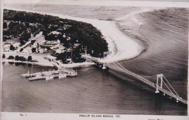 Phillip Island and District Historical Society Inc.
Photograph, Phillip Island Bridge, 1940
The bridge built around 1939. Fishing fleet. Twin jetties to left of bridge, township, bush and wide sand strip of surf beach.Bridge between Phillip Island and San Remo. Photograph depicting San Remo onlyNo. 1. Phillip Island Bridge, Vic. Airspy Photolocal history, photographs, bridges, san remo, coastline, bridge, fishing fleet, jetties, bruce bennett -
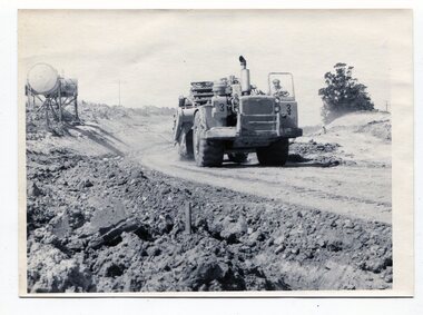 Orbost & District Historical Society
black and white photographs, C1975
These four photographs show the construction of the Princes Freeway on the eastern edge near the cemetery. of the Orbost township. The road is from the eastern entrance to the cemetery.These photographs are pictorial records of the construction of roads in Orbost.Four black / white photographs of road construction machinery.road-construction-orbost roadwork-orbost-cemetery -
 Marysville & District Historical Society
Ephemera (Item) - Information brochure, Anastasia's COTTAGES, Unknown
An information brochure regarding Anastasia's Cottages in Marysville. These cottages, along with most of the buildings in the township, were destroyed in the 2009 Black Saturday bushfires.An information brochure regarding Anastasia's Cottages in Marysville.marysville, victoria, australia, anastasia's cottages, information brochure, accommodation, 2009 black saturday bushfires -
 Marysville & District Historical Society
Ephemera (Item) - Information brochure, Anastasia Fairytale Cottage, Unknown
An information brochure regarding Anastasia Fairytale Cottage in Marysville. This cottage, along with most of the buildings in the township, was destroyed in the 2009 Black Saturday bushfires.An information brochure regarding Anastasia Fairytale Cottage in Marysville.marysville, victoria, australia, information brochure, accommodation, anastasia fairytale cottage, 2009 black saturday bushfires -
Donald History and Natural History Group operating the Donald Court House Museum
Tool #1
This wooden handle tool was used by Georgie Ah Ling, who operated a market garden on the edge of the township of Donald for over 70 years.Rounded conical shaped wooden handle with metal pointed needle.tool, wooden handle, georgie ah ling, market garden, donald -
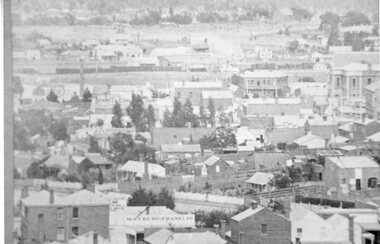 Stawell Historical Society Inc
Photograph, Panoramic view from Big Hill with the Town Hall and Coffee Palace formerly Castlemaine Hotel & aso the Train at Station 1880
Stawell Township from Big Hill 1880 Town Hall and Coffee Palace formerly Castlemaine Hotel, can be seen. Train at Station.stawell -
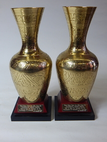 Katamatite Museum, operated by the Katamatite Historical Society
vase momento at proclamation of township of Katamatite
The 2 vases were a gift to the museum .An eucumenical church service was held to mark the centenary of the procla. ..mation as a township November 17th 1985..2 brass vases placed on timber stands-.stands have inscriptionbrass vases with engravings .On timber base is inscription date 17th November 1985. -
 Buninyong & District Historical Society
Photograph - B/W photograph, Mrs. Bon Strange (nee Lorensini), Old Brewery and Gong Reservoir Buninyong, c 1935, c1935
Early gold-rush building, originally Brewery, next to Gong Reservoir (early water source for township). Building since converted to residence.Record of early building as of mid 1930'sLaser copy of hand-tinted photograph of Old Brewery and Gong Reservoir Buninyong, c 1935, fields rising behind, tall treees, partially obscured house.building, buninyong, brewery, industry, landscape -
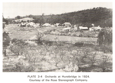 Eltham District Historical Society Inc
Work on paper (Sub-Item) - Photograph, Orchards at Hurstbridge, 1924
With the extension of the railway to Hurstbridge in 1912, large commercial orchards were able to expand. By 1914, 1,886 acres of orchards were under cultivation, with a considerable proprotion of the fruit being exported overseas. After World War One, the industry declined, mainly due to competition from other areas. This photo shows an orchard in the foreground with the township of Hurstbridge in the distance. The photo was taken in 1924, the same year that Hurstbridge was declared a township. orchard, hurstbridge, rose postcard -
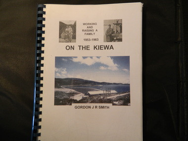 Kiewa Valley Historical Society
Book - On the Kiewa, Working & Raising a Family 1953 - 1963 by Gordon J. R. Smith, 9th September 2005
Personal account of Gordon Smith's life when living in Mt Beauty and Bogong townships while working for the SECV on the Kiewa Hydro Electric Scheme.Gordon gives an account of both working and living during the 1950s and early 1960s in a remote part of Victoria - the Kiewa Valley and in 2 small construction towns. He gives a lot of detail eg. the weather, his work, the people, the activities, his family and leisure time.Plastic threaded spine holding 282 pages with black and white photos. Front Cover includes 2 small black and white photos either side of the title at the top and below the title a larger colored photo of Rocky Valley Dam. Author's name is underneath. "Dick Puttyfoot" on cover page.kiewa hydro electric scheme, state electricity commission of victoria., gordon smith -
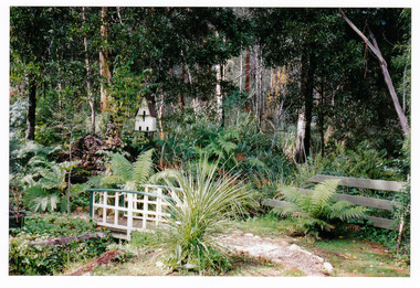 Marysville & District Historical Society
Photograph (Item) - Colour photograph, Unknown
A colour photograph of the rear gardens at Arbor Green Galleries in Marysville. This cottage, along with most of the buildings in the township, was destroyed in the 2009 Black Saturday bushfires.A colour photograph of the rear gardens at Arbor Green Galleries in Marysville.Arbor Green Gardens/ 1 Falls Rd M'sville./ Rear gardenmarysville, victoria, australia, photograph, accommodation, arbor green cottage, 2009 black saturday bushfires -
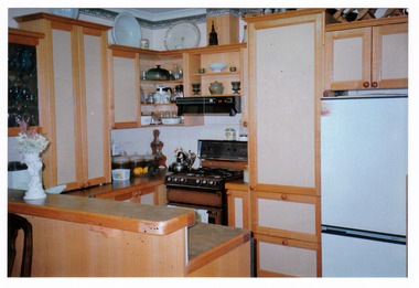 Marysville & District Historical Society
Photograph (Item) - Colour photograph, Unknown
A colour photograph of the kitchen in the cottage at Arbor Green Galleries and Cottage. This cottage, along with most of the buildings in the township, was destroyed in the 2009 Black Saturday bushfires.A colour photograph of the kitchen in the cottage at Arbor Green Galleries and Cottage.1 Falls Rd. M'sville./ Cottage Kitchen.marysville, victoria, australia, photograph, accommodation, arbor green cottage, 2009 black saturday bushfires