Showing 13708 items
matching wye-river-bridge
-
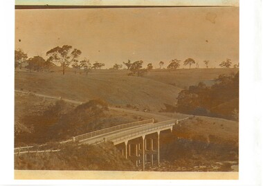 Buninyong & District Historical Society
Photograph - Sepia photograph of original, Leigh Grand Junction Bridge, Leigh Grand Junction Bridge
Bridges, reinforced concrete construction by C.C.P.WilsonSepia photo, Photo of concrete bridge spanning gully, rolling landscape with scattered trees. leigh grand junction bridge, c.c.p. wilson -
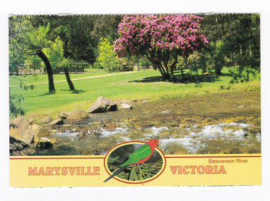 Marysville & District Historical Society
Postcard (item) - Colour postcard, Neil Cutts, Marysville Victoria-Steavenson River, Pre 2009
A postcard in a series produced by the Rose Stereograph Company in Victoria, Australia as a souvenir of Marysville.A colour photograph of the Steavenson River which flows through Marysville in Victoria. The Rose Series postcard No. 3527.POST CARD The "Rose" Series/ De Luxe Proudly Printed in/ Australia Since 1880 AFFIX/ STAMP/ HERE/ Rose Series/ Post Card No./ 3527 ADDRESS/ POSTCODE Steavenson River/ MARYSVILLE, VICTORIA, AUSTRALIA/ Photo Neil Cutts Copyright Rose Stereograph Co., Glen Waverley, Victoria (03) 9560 7772marysville, victoria, steavenson river, postcard, souvenir, rose stereograph co, 3527 -
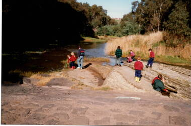 Sunbury Family History and Heritage Society Inc.
Photograph, River studies
Students from Bulla Primary school were taken to the nearby Deep Creek to study some of the river life inn the local water course.Bulla township is situated in the Deep Creek valley and was an ideal place to take students to study river life close to their school.A coloured photograph of eight children with two adults standing on a rocky outcrop beside a river and looking at the riverlife in the water.rivers, deep creek, river studies, bulla, bulla primary school -
 Wodonga & District Historical Society Inc
Album - Ringer's River by Des Martin - Plate 8 - O'Day meets Grapeshot
Pushing his mob along the back boundary of Barmagulla Station, whose owner, Edmund Montieth, a wealthy, well educated, and forward thinking gentleman accepted as a leader of the N.S.W. pastoralists "just across the border", O'Day hears the shrill whinny of a stallion. On riding over to investigate he finds that, in the practise of the day, a superb thoroughbred horse has been turned out on the river flats to acclimatise. Later he learns that this is Grapeshot, a classic winner just imported from England.The albums and images are significant because they document literature written by a prominent member of the Wodonga community. The presentation of this precis was supported by several significant district families and individuals.Ringer's River Album Coloured photo Plate 8des martin, many a mile, ringer's river, northeast victoria stories -
 Phillip Island and District Historical Society Inc.
Photograph, Phillip Island Bridge, 1968/9
Final stages of construction of 2nd Bridge (1968/69) connection San Remo with Newhaven. From the Jack Jenner Collection.Close-up of placing of middle Span of Bridge 1968/69.local history, photographs, civil engineering, bridges, phillip island bridges, black & white photograph, jack jenner collection, public construction -
 Warrnambool and District Historical Society Inc.
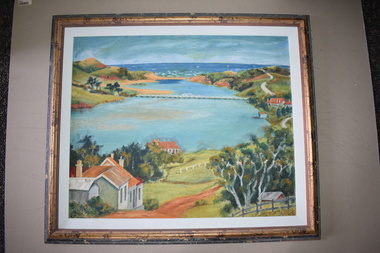
Framed Paintings, 1 The Frame Shop, Fairfield, Melbourne .2 Kardinia Picture Framing, Geelong, 1Warrnambool Botanical Gardens .2 Hopkins River, Warrnambool, 1953
These two works of art are by Dr Don Edgar, a sociologist, educator and author. He taught sociology at Stanford University, the University of Chicago, Monash University and La Trobe University and was the founding Director of the Australian Institute of Family Studies. In the 1950s Dr Edgar was a student at Warrnambool High School and these works of art were produced at that time. For a school project he researched the early history of the Warrnambool Art Gallery and some of its collection, dating from the 19th century. In 2019 he published a book, ‘Art For the Country’, the story of Victoria’s regional art galleries and the book includes information on the founding and the later history of the Warrnambool Art Gallery.These works of art are of interest as they were painted by Dr Don Edgar, a noted academic and author today and a former resident of Warrnambool. The two works of art also have historical interest as they depict Warrnambool scenes painted over 60 years ago. .1 An art work (oil on artboard) – the Warrnambool Botanical Gardens with bridge and reflections, a gum tree and a poplar tree, all in green and orange tonings. The wooden frame has a light varnish with gold and white trim .2 An art work (oil on artboard) – multi-coloured view of the mouth of Hopkins River with the Hopkins River bridge, Lyndoch bungalow and boathouse. The frame is wooden with a mottled varnish and a white insert edging. .1 Don Edgar 1953 Don Edgar 1953 (High School Student) .2 D.E. 53 Don Edgar 1953 (High School Student) dr don edgar, sociologist, author and educator, warrnambool art gallery, history of warrnambool -
 Bendigo Military Museum
Photograph - PHOTOGRAPH, TAMARAN BRIDGE, British Air Force, C1943-1945
Refer Cat no. 5445.2Photo shows flat, uninhibited land. A river (low tide) snakes through the photo. In the centre is a trestle bridge crossing the river. A bomb ( water and smoke) blast is rising from the side of bridge Photograph rear in ink. “Tamaram bridge" being bombed. Bridge built by POWS. The span was never rebuilt. Trains stopping both sides and goods carried along foot of bridge, on a narrow bridge by POWs.ww2, pow, tamaran bridge, burma railway -
 Ballarat Heritage Services
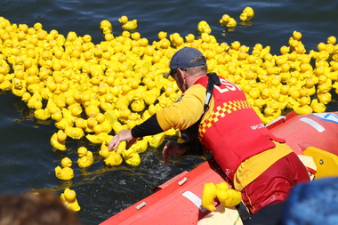
Digital photographs, L.J. Gervasoni, Moyneyana Ducks, c2013
Each new year's day there is a duck race at Port Fairy on the Moyne River. Colour photograph of rubber ducks in the Moyne River on new year's day. landscape, river, moyneyana, duck race, fundraiser, slsc, surf life saving club, port fairy, rubber ducks, moyne river -
 Orbost & District Historical Society
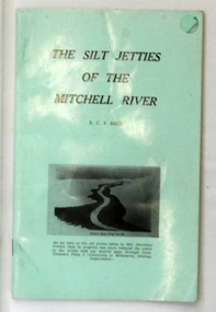
book, James Yeates & Sons (Printing) Pty Ltd, The Silk Jetties of the Mitchell river, 1972
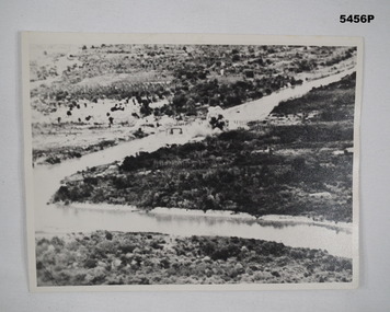
This booklet was the first of a series of scientific and historical studies of Gippsland to be published by the Bairnsdale Advertiser. The author, Eric Charles Frederick Bird was Principal Fellow, Department of Geography, University of Melbourne, Australia. The Mitchell River silt jetties are an unusually long, thin landform located in the Gippsland Lakes region. They have been formed over millions of years by sediment deposition from the Mitchell River during periods of low water flow and subsequent wash-through during periods of high water flow. The long narrow banks of silt extend more than eight kilometres east into Lake King. This item is a useful reference for the silt jetties of the Mitchell River.A 32 pp book with alight green cover. The title is in black print, " The Silk Jetties of the Mitchell River" and underneath the title there is a b/w photograph of the Mitchell River and silt jetties taken from above in 1931. It was written by E. C. F. Bird.silt-jetties mitchell-river paynesville bird-e.c.f. -
 Orbost & District Historical Society
photograph, first half of 20th century prior to 1976
Purchased from Orbost Op shop several years ago. Original owner unknown. This bridge over the Snowy River was opened on July 4 1922. It was constructed in 1922 alongside the previous suspension bridge. Its building was a combined effort of the Victorian Railways and the Country Roads Board at a cost of 35,000 pounds. It was replaced in 1976 by the present bridge after several major floods.This bridge was replaced in 1976 after several major floods.A wooden framed photograph of the second Snowy River bridge at Orbost.photograph snowy-river-bridge -
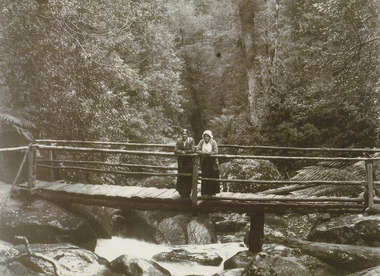
 Marysville & District Historical Society
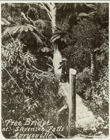
Photograph (item) - Black and white photograph, Tree Bridge at Stevenson Falls Marysville, Unknown
An early black and white photograph of a tree bridge at Steavenson Falls in Marysville in Victoria.An early black and white photograph of a tree bridge at Steavenson Falls in Marysville in Victoria. The Steavenson Falls are named after the Victorian Assistant Commissioner of Roads and Bridges, John Steavenson who arrived in Victoria in the early 1860s.tree bridge, stevenson falls, steavenson falls, waterfalls, marysville, victoria, john steavenson -
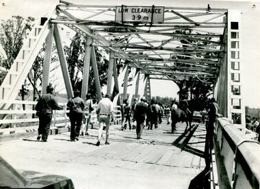
 Phillip Island and District Historical Society Inc.
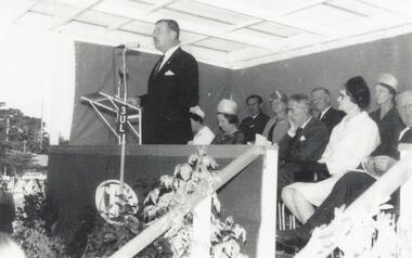
Photograph, Phillip Island Bridge Opening, 1969
Opening of second Bridge in 1969 by Hon. Porter, Minister for Public Works. From the Jack Jenner Collection.Opening of second Bridge 1969 by Minister of Public Works, Hon. Porter.local history, photographs, civil engineering, bridges, opening of 2nd phillip island bridge, black & white photograph, jack jenner collection, phillip island bridges, public construction, hon. porter minister for public works -
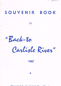 Otway Districts Historical Society
Book, "Back to Carlisle River", 1967
The settlement and settlers of Carlisle River, first known as "New Church Run" in 1861 until its name change in 1890-91.Souvenir bbok of "Back to Carlisle River", 1967. Colac (Vic); Herald Print; 1967. 25 p.; illus. Soft cover.Under Hotel, an insertion entitled "The Carlisle Hotel" containing the names of the licencees until its surrender on 31 December 1928.carlisle river; new chuch run; butter; history; sport; -
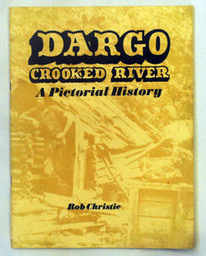 Orbost & District Historical Society
book, Enterprise Press Pty Ltd, Dargo Crooked River, C 1994-1997
This is a pictorial history of the Crooked River district.This is a useful reference tool on the history of gold mining in the Dargo area.A thin 56 pp paperback book titled,"Dargo Crooked River a Pictorial History". On the yellow front cover is a sepia photograph of a man standing outside a rough wooden hut. The title and author are printed in black text over this. The book contains Black / white photographs and the history of Dargo and Crooked River. The information is divided int decades. Inside there is a newspaper cutting of Victorian cattlemen on Junction Plain near Omeo.dargo-crooked-river gold-mining east-gippsland-history -
 Stawell Historical Society Inc
Photograph, Dunmunkle Creek where it originally connected to Wimmera River 2017 -- Coloured
Colour Photo of Dunmunkle Creek originally connected to Wimmera River at this point. Just before the Glenorchy Weir. 2017Colour photograph of what looks to be a dry creek bed. Timber on creek bank. Dunmunkle Creek originally connected to Wimmera River at this point. Just before the Glenorchy Weir (Photo taken 2017) water -
 Port Fairy Historical Society Museum and Archives
Photograph, 1906
Iron Steamship Casino in the Moyne River 1906B&W photograph of the SS Casino moored in the Moyne River opposite the lifeboat shedship, boat, sea, river, casino -
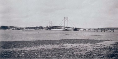 Phillip Island and District Historical Society Inc.
Photograph - Photogragh, Photographs of the opening of the Phillip Island suspension bridge from Newhaven and San Remo
Suspension bridge was opened in 1940. Historical4 small black & white photographs of opening of suspension bridge, showing infrastructure and people and cars attending.Nonefirst phillip island bridge to san remo, phillip island bridge opening -
 Marysville & District Historical Society
Photograph (item) - Black and white photograph, Unknown
A black and white photograph of two ladies standing on a timber bridge crossing the Taggerty River.A black and white photograph of two ladies standing on a timber bridge crossing the Taggerty River.taggerty river, timber bridge -
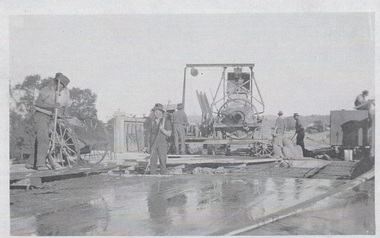
 Peterborough History Group
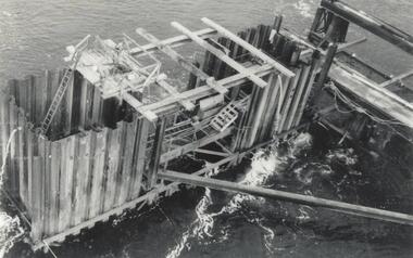
Photograph - Bridge Construction 1927
The bridge over the Curdies River was constructed using funds raised by the Peterborough residents. The bridge was important to allow ease of access rather than having to cross using a boat.Bridge provided important access to the area.Series of 9 photographs showing the progress of the construction of the bridge over the Curdies River in 1927Several of the photographs have handwritten dates, from June 1927 to November 1927curdies river, curdie river bridge, peterborough, great ocean road, bridge construction -
 Orbost & District Historical Society
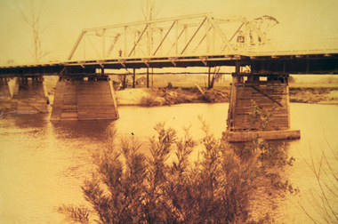
black and white photograph, 1976
This bridge over the Snowy River was opened on July 4 1922. It was constructed in 1922 alongside the previous suspension bridge. Its building was a combined effort of the Victorian Railways and the Country Roads Board at a cost of 35,000 pounds. It was replaced in 1976 by the present bridge after several major floods. This photograph shows people walking over the bridge for the last time.This is a pictorial record of the former Snowy River Bridge at Orbost.A black / white photograph showing a group of people walking across a bridge. There are several cars, a man on a horse and people standing on the side of the roadway.on back - "1976 - old bridge"snowy-river-bridge-1976 -
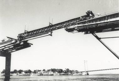
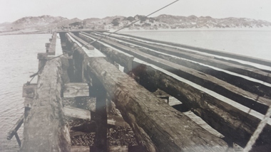
 Phillip Island and District Historical Society Inc.
Photograph, Phillip Island Bridge, 1968/9
Construction of 2nd Phillip Island Bridge. 1969. From the Jack Jenner Collection.Scaffolding for concrete works for new Bridge. Top view of empty forming close-up.local history, photographs, civil engineering, bridges, phillip island bridges, black & white photograph, jack jenner collection, public construction -
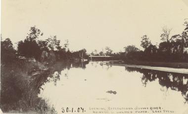 Lakes Entrance Historical Society
Postcard - Snowy River bridge, H D Bulmer Lake Tyers, Orbost Victoria, 1905 c
Black and white postcard taken of Snowy River with bridge in distance at Orbost VictoriaEvening Reflections Snowy Riverwaterways, bridges, rivers -
 Stawell Historical Society Inc
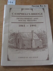
Book, Ken Hyslop, Campbells Bridge – Development and Social History 1861-1991, 1991
Compiled by Ken Hyslop for the Back to Campbells Bridge in November/ December 1991.Fawn Card Cover brown border enclosing title and sketch of house, and authors nameCampbell's Bridge Development and Social History 1861-1991. Compiled By Ken Hyslop.stawell -
 Vision Australia
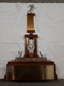
Photograph - Image, River Run Female Winner trophy
A race along the banks of the Yarra River (?) this trophy was awarded to the female winners from 1978-1987. A golden running figure sits atop a pedestal that rests on a bell located above two pedestals behind a golden laurel wreath. Two eagles, with wings outstretched as if just landing, are either side of the wreath and the inscription 'Rotary Club of Glenferrie - River Run - Female winner - Donated by Bob Bruner' is written on the plinth below them. On the base plinth are inscribed the names of the previous winners: 1978 Lynne Williams 1979 Lynne Williams 1980 Lynne Williams 1981 Dorothy Browne 1982 Dorothy Browne 1983 Michelle Baumgarten 1984 Laura Dess 1985 Mary Edwards 1986 Julie McKie 1987 Julie McKieGold running figure atop two levels of columns with a wreath and two eagles at the base, whereupon names are inscribedRotary Club of Glenferrie River Run Female Winner Donated by Bob Brunerassociation for the blind, awards -
 Clunes Museum
Artwork, other - LITHOGRAPH, Adelaide, From the River Torrens
Dark sepia scene, on linen surface paper. Depicting Torrens River, with bridge and city buildings in background. Tree lined banks, 2 figures on left bank and 3 rowing boats on river. 4 figures on right bank. Picture is mounted on 10mm thick chipboard which is coloured black.Scheil - A Irwin Sclithograph, torrens river -
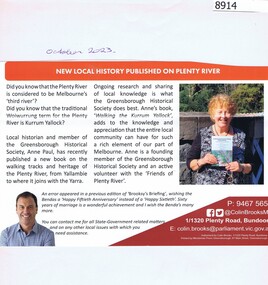 Greensborough Historical Society
Article - Newsletter Clipping, Colin Brooks, New Local History published on Plenty River, 2023
Article about Anne Paul's book, "Walking the Kurrum Yallock" regarding the walking tracks and heritage of the Plenty River, from Brooksy's BriefingPrinted article about book written by Anne Paul regarding th walking track and heritage of the Plenty River from Brooksy's Briefingplenty river, anne paul, greensborough historical society, colin brooks -
 Wodonga & District Historical Society Inc
Photograph - Construction of Wodonga Creek Bridge, 1920
The bridge over Wodonga Creek was opened on Friday 20th October 1922 by the Minister For Public Works Mr Frank. The erection of the bridge was carried out by Mr L Carr, of Brighton. The new concrete bridge was a little more than 500 feet long and consisted of 12 spans. The decking was supported by a number of steel girders, each weighing approximately seven tons. The whole bridge was supported by rows of three cylinders, sunk to a depth of 26ft below the summer water level. The original estimated cost of the structure was £20,000, but with the extras added during construction this amount was exceeded.These photos are significant because the capture the construction of an important bridge between Albury and Wodonga.Three black and white photographs taken during the construction of the new bridge over the Wodonga Creek in 1920.wodonga bridges, wodonga creek -
 Wodonga & District Historical Society Inc
Album - Ringer's River by Des Martin - Plate 32 - The shooting of Nugent
Advised of the tragedy by one of the stockmen Ellen O'Hara drives the gig towards Overton, but meets Klinberg who tells her the police have found a body near Nugent's place. Ellen gets there as Nugent is pulling Keiran's body from the river. Shock grief, and old bitternesses unhinge her mind. Seizing Trooper Ryan's pistol from on top of his clothes she shoots Nugent dead, and bolts up a rough back track towards her home with the police in pursuit. Her pony falls while belting along a narrow, dangerous piece of the track, and the gig goes over a cliff. Ellen is killed.The album and images are significant because they document literature written by a prominent member of the Wodonga community. The presentation of this precis was supported by several significant district families and individuals.Ringer's River Album Coloured photo Plate 32des martin, many a mile, ringer's river, northeast victoria stories -
 Ballarat Heritage Services
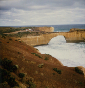
Photograph, London Bridge, Great Ocean Road, 01/1990
London Bridge, pre 1990 was a double-spanning bridge connected to the mainland. The stack was created over hundreds of years, with the weaker layers toward the base being eroded away by wind and water to form the two bridges. The span closer to the shoreline collapsed unexpectedly on 15 January 1990, leaving two visitors, whilst uninjured, stranded on the outer span before being rescued by helicopter. Two coloured photographs of the London Bridge, on the Great Ocean Road. This photo was taken days before the collapse of the geological feature. The photographer walked across the bridge to the warning of her mother "if you go over there and it collapses you will be stuck. After the collapse it was renamed London Arch. london bridge, great ocean road, london bridge, peterborough, london arch, shipwreck coast, 12 apostles -
Marysville & District Historical Society
Flyer (item) - Information Flyer, Artworkz Tourism, Marysville-Historic Timber Tramway Trestle Bridge, Post 2009
A flyer that was produced as a guide to the historic timber tramway trestle bridge near Marysville in Victoria.A flyer that was produced as a guide to the historic timber tramway trestle bridge near Marysville in Victoria. The historic timber tramway trestle bridge is along the Michaeldene Walking Track near Marysville in Victoria. The Michaeldene Trail to Taggerty River Lookout is a 4.3 kilometer lightly trafficked loop trail located near Marysville, Victoria. The track is one of several walking tracks located in and around Marysville in Victoria.timber tramway trestle bridge, marysville, victoria, michaeldene walking track, taggerty river, taggerty river lookout