Showing 11430 items
matching maps
-
 Melbourne Tram Museum
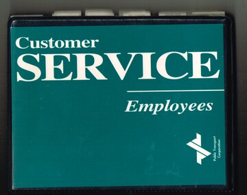
Book, Public Transport Corporation (PTC), "Customer Service Employees", c1995
Black vinyl covered two ring folder titled "Customer Service Employees", with the Public Transport Corporation Logo printed on dark green paper. Contains approx. 120 sheets with information about Melbourne's public transport including general information, maps, fares, Met Tickets (3 zones), disabilities, sports and entertainment Map, Hospitals, AFL Grounds, Bus & Tram Services, Night Rider Bus Services and basic first aid. The map shows tram line to Bundoora but no services to Docklands, the Altona - Laverton rail line shown. Gives details of Ansett airlines office. Book not dated as such. Estimated date - mid 1990's, prior to Metcards, still using Met tickets.trams, tramways, ptc, the met, tickets, information, melbourne, buses -
 Bendigo Military Museum
Map - Australian Topographical Survey NAGAMBIE SW Sheet, 1 inch:1 Mile, NW portion Plane Table Field sheet 1921, Australian Survey Corps, 1921
This is a coloured reproduction print of an original Plane Table compilation map sheet of Nagambie area 1inch to 1 Mile scale compiled by Sgt Jack Cullen Australian Survey Corps 30 September 1921. Jack was one of the foundation members of the Australian Survey Corps. Of particular interest is the fact that this is a heighted compilation with contouring (required for Military use) as many early maps were purely planimetric. A table on the right hand side details the number of days that it took to produce the compilation. The reverse side of this print is a copy of the Tallarook plane table South East field sheet.Reprinted coloured Image of Australian Topographical Survey NAGAMBIE SW Sheet,1 inch:1 Mile, NW portion hand drawn Plane Table Field sheet. Includes an itemized summary of work, signed by Sgt J Cullen Australian Survey Corps September1921.royal australian survey corps, rasvy, fortuna, army survey regiment, army svy regt, asr -
 Bendigo Military Museum
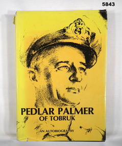
Book - BOOK, AUTOBIOGRAPHY WW2, A. B. Palmer, "Pedlar Palmer of Tobruk", 1981
Owner and donor details, see Cat. No. 5836.3.Hard cover book with dust cover. Cover - cardboard with navy blue buckram. Gold print on spine. Dust cover - paper, black colour print on yellow background, front and spine. Front illustration - black print of RAN portrait. Back cover, sepia tones, photograph of trucks and boats dockside. 384 pages, cut, plain, white paper. Illustrated black and white photographs and maps. End papers front and back - maps.books, military history, ww2, ran, autobiography -
 Bendigo Military Museum
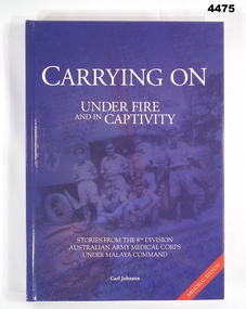
Book - BOOK, 8TH DIVISION AAMC, Carl Johnson, "CARRYING ON UNDER FIRE AND IN CAPTIVITY", 2009
Stories from the 8th Division Australian Army Medical Corps under Malaya Command, WWII. The 39th Australian Infantry Battalion (1941-1943) Association donated four books of Military History: Cat. No. 4474 With the Twenty-Second Cat. No. 4475 Carrying On Under Fire and in Captivity Cat. No. 4476 Mod Revisited Cat. No. 4477 Forward With The FifthHard cover - cardboard with dark blue glossy coloured background. White print on front, spine and back. Front illustrated black and blue toned photograph of 6 Medical Corp Soldiers in uniform. Back, photograph of trestle bridge on Thai-Burma Railway. Front and back figleaf and end papers illustrated with grey/blue and white maps. 559 pages, cut, plain, white. Illustrated black and white photographs, portraits, maps, drawings.Opposite Title Page - printed donation label - "Donated by 39th Australian Infantry Battalion (1941 - 1943) Association Inc, www.39battalion.com” Association Inc. www.39battalion.com"books, military, history, wwii -
 Bendigo Historical Society Inc.
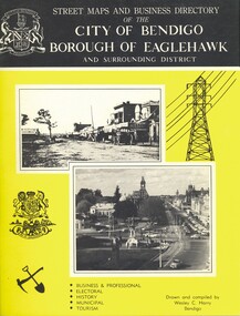
Book - STREET MAPS AND BUSINESS DIRECTORY OF THE CITY OF BENDIGO, c1972
Street Maps and Business Directory of the City of Bendigo Borough of Eaglehawk and Surrounding District : with Classified Business Directory (1973). Drawn and compiled by Wesley C Harry. Publisher: Cambridge Press, Bendigo. 88 pages. Includes b/w photographs, illustrations & maps. Information on the shires that make up Bendigo. History of the name of Bendigo. Historical pictures with notes. Advertisements for local businesses. Signed - Alec S Craig, mayor. Grace A. O. CraigWesley C Harrybook, bendigo, bendigo & district maps, streets & localities bendigo & district, businesses, historical notes of bendigo -
 Bendigo Historical Society Inc.
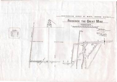
Map - STRUGNELL COLLECTION: UNDERGROUND SURVEY OF MINES, BENDIGO DISTRICT, 7-1-99
Map, Underground Survey of Mines Bendigo District.Frederick the Great Mine, Sebastian. A collection of nine (9) maps of the mine, Signed H.S.Whitelaw Field Geologist 4.1.99 with some notes relating to same, including a: * Typed overview of the operation of the mine in 1912. * Clipping from Victoria its Mines and Minerals detailing the operation of the mine from its beginning in 1863 where it was first worked for alluvial. Charlton & Co., and Mr. Glass mentioned in article.A.S.Whitelawmap, bendigo, frederick the great mine -
 Bendigo Historical Society Inc.
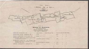
Document - KELLY AND ALLSOP COLLECTION: HUSTLERS LINE OF REEF MAP, 30/07/1891
Document. KELLY & ALLSOP COLLECTION. Map of the Hustlers Line of Reef, Bendigo (South portion). Issued by Wood & McNair, Sharebrokers, Beehive Chambers, Bendigo and High St., Eaglehawk. Mines shown on map are Fortuna Hustler's Co., Hustler's Royal Reserve No.2, Great Extended Hustlers Co., Hustlers Reef Co., Hustler's Reef No.1 Co., United Hustler's & Redan Co. Number of shares is listed against each of these mines.Wood & McNairbusiness, stockbroker, kelly & allsop, kelly & allsop collection, hustlers line of reef map, wood & mcnair. -
 Ringwood and District Historical Society
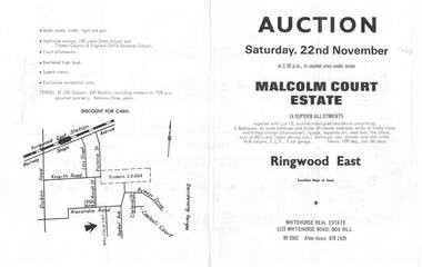
Flyer, Land Auction Brochure, Malcolm Court Estate, Ringwood East, Vic. - 1969
Bi-folded single sheet with black print both sides advertising Auction on Saturday, 22nd November, 1969. Details include location map, vendor terms, subdivision features and local facilities. Centre page shows allotment numbers and property dimensions. Agent - Whitehorse Real Estate, 1123 Whitehorse Road, Box Hill, (Phone) 890502, After hours 8781429. Separate copy of map with handwritten sale notations for some allotments.LP 859686 -
 Melbourne Tram Museum
Document - Research Notes, Ron Scholten, "Key Dates - Prahran and Malvern Tramways Trust", 2010
Two A4 sheets stapled titled "Key Dates - Prahran and Malvern Tramways Trust" and PMTT Map on page 2 giving opening dates , and other important dates for the Trust. Has the PMTT logo, reproduction of a painting of No. 26 by Graham Lee and two PMTT drawings of a single truck 4 wheel tram and a Maximum Traction bogie tram. Map shows the railway lines, cable lines, PMTT lines and HTT lines.trams, tramways, pmtt, history, opening, htt, kew -
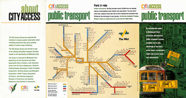 Melbourne Tram Museum
Pamphlet, The Met, "City Access Public Transport", mid 1980's
Pamphlet - four fold DL - gloss paper - titled "City Access Public Transport", providing maps and details of public transport, city circle, ticket information. Includes The Met system map and images of a W class with a destination of Football and Daily Adult Zone 1 tickets. Printed primarily for tourists. Published by The City of Melbourne, , The Met and the City Access group. Rear cover includes a list of those involved in City Access.trams, tramways, city centre, city of melbourne, public transport, tourism, tourist guides -
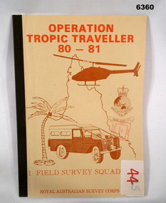 Bendigo Military Museum
Administrative record - Operation Tropic Traveller 80 - 81 1 Field Survey Squadron, 1981
Project report, Operation Tropic Traveller 1980/81 was mounted to field complete the North Queensland Tac map area during the periods 25 Feb to 11 Nov 1980 and 3 Mar to 13 Oct 1981 Buff colored, A4 Folder, Mosaic in brown of Nth Qld, Helicopter, Corps badges, Land rover.1 field survey squadron, 1 fd svy sqn, royal australian survey corps -
 Glen Eira Historical Society
Map - Brighton Cemetery, North Road, Caulfield South
Photocopy of a typed letter from the National Trust (Victoria), dated 23/10/1997, to Brighton Cemetery Trust, notifying of the classification o the cemetery in the National Trust Register. An undated photocopy of a map and plan of Brighton Cemetery.brighton cemetery, north road, caulfield south, burke chris, brighton cemetery trust, sheffield road, hawthorn road, cemeteries, grave yards -
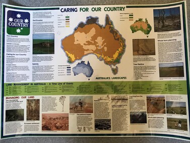 Greensborough Historical Society
Poster, National Farmer's Federation et al, Caring for our Country, 1988c
A timeline of land management including indigenous care and the impact of European settlement from 1988 to 1987. Includes maps showing present land use and vegetation coverage in 1788. Prepared by Tim Gurry for the National Farmer’s FederationLaminated poster, printed in colour on one side.land management, farming, salinity -
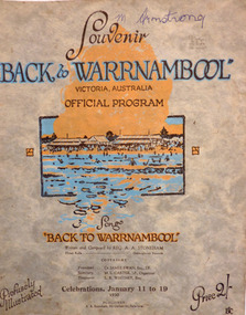 Warrnambool and District Historical Society Inc.
Programme - Back to Warrnambool 1930 official souvenir program, January, 1930
This booklet contains the Program for the Back to Warrnambool Celebrations for 1930. It contains a brief history of the town and photos of current council Office bearers and local scenic spots. There is also a map of the town and a large number of advertisements for local businesses. Back to Warrnambool celebrations were an important event on the social calendar and were run over a number of years in the town. This program is one glimpse into the city and its people in 1930. Some of the events held over the week included processions, sports Carnivals, concerts, card playing, Church services and local tours. Many of the advertisements are for businesses of long standing and importance to the prosperity of the town. Twenty page Booklet with light card, grey, mottled cover. Text in brown and blue. Picture of Warrnambool main beach in centre. Price 2/- in bottom right corner. Back cover has full page advertisement for Bruce and McClure. Text and illustrations are brown. M Armstrong is written in blue biro on top right corner. Song “Back to Warrnambool,” written and composed by Reg A.A. Stoneham,” is printed below picture on front cover. Published by A.A. Stoneham, 241 Carlisle St, Balaclava.younger pty ltd, warrnambool, back to warrnambool, 1930, souvenir program, warrnambool cordials, morse pty, swinton, warrnambool cheese and butter factory, batros shoes, tattersalls hotel, bruce and mcclure, warrnambool woollen mill, reg a. a. stoneham -
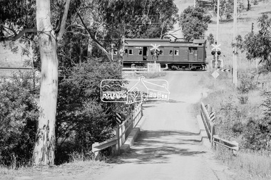 Eltham District Historical Society Inc
Photograph, George Coop, Single Motor Carriage 471M Tait (Red Rattler) train crossing Allendale Road, heading to Eltham station, 6 December 1980, 1980
The single carriage Tait regularly ran between Eltham and Hurstbridge stations. Looking east along Allendale Road, Eltham to the railway level crossing. The tree on the left remains today (2019) https://goo.gl/maps/zngEcUA29tEWFzuj7Digital TIFF file Scan of 35mm Ilford FP4 black and white transparency471m, allendale road, eltham, hurstbridge line, railway level crossing, red rattler, single motor carriage, tait train -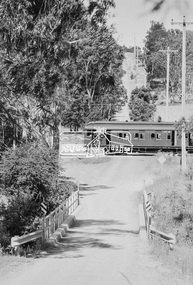
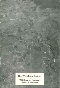 City of Whittlesea
Booklet (item), The Whittlesea District
The Whittlesea district / Whittlesea Agricultural Society publication, 16 pages, black and white photographs, maps, graphs. Booklet provides a brief history and analysis of farming in the Whittlesea district up to the late 1940s. Publication c.1950sbooklet -
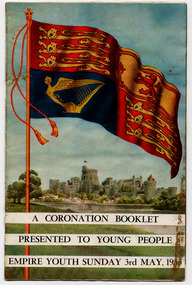 St Kilda Historical Society
Document - Booklet, A Coronation Booklet Presented to Young People Empire Youth Sunday 3rd May 1953, 1953
Booklet to commemorate the coronation of Elizabeth II. Contains coloured photos of Royal regalia. The front cover shows the Royal Standard and Buckingham Palace. The back cover shows a map of the route from Buckingham Palace to Westminster Abbey.Multi-page booklet with cover printed in colour and the internal pages in black and white text and some coloured photographs. Stapled.queen elizabeth ii, queen elizabeth ii coronation -
Lakes Entrance Historical Society
Book, Environment and Heritage Report, 1996
163 printed pages in report, following this are 9 Appendices labelled A-I, Appendix 1 also refers to sub-appendices 1-5, plastic sleeve inside rear cover contains maps, wire spiral boundComprehensive Regional Assessment, buff coloured cover with superimposed leaf pattern, left side of cover is brown, rear cover monotone buff with leaf patterndocuments, reports -
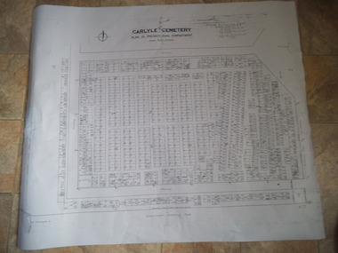 Rutherglen Historical Society
Carlyle Cemetery Map, Plan of Presbyterian Compartment, 1952
This is a map produced to attempt to bring order to the cemetery. Originally the layout was not well defined and it is difficult to use this plan to locate a particular grave, also the fact that not all graves are marked and foot paths are not defined has exacerbated this issue. Photocopy, White paper, black printing, black line work showing lot and compartment boundariesReferences Grid Survey points at 50 feet centres shown (as a cross with the reference mark number in brackets) Lot Number shown at left side of graves. Burial Number shown at right side of grave. Lots with unidentified burials show with dashed cross with in the lot. topographic survey, cadastral survey, carlyle cemetery, burials, graves, lot boundary, rotunda -
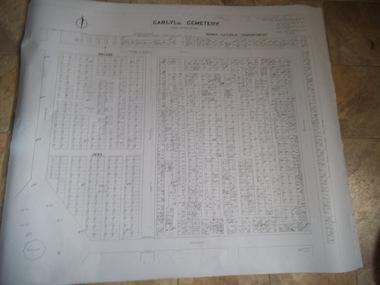 Rutherglen Historical Society
Carlyle Cemetery Map, Plan of Roman Catholic Compartment, 1952
This is a map produced to attempt to bring order to the cemetery. Originally the layout was not well defined and it is difficult to use this plan to locate a particular grave, also the fact that not all graves are marked and foot paths are not defined has exacerbated this issue. Photocopy, White paper, black printing, black line work showing lot and compartment boundariesReferences Grid Survey points at 50 feet centres shown (as a cross with the reference mark number in brackets) Lot Number shown at left side of graves. Burial Number shown at right side of grave. Lots with unidentified burials show with dashed cross with in the lot. topographic survey, cadastral survey, carlyle cemetery, burials, graves, lot boundary, rotunda -
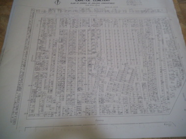 Rutherglen Historical Society
Carlyle Cemetery Map, Plan of Church of England Compartment, 1952
This is a map produced to attempt to bring order to the cemetery. Originally the layout was not well defined and it is difficult to use this plan to locate a particular grave, also the fact that not all graves are marked and foot paths are not defined has exacerbated this issue. Photocopy, White paper, black printing, black line work showing lot and compartment boundariesReferences Grid Survey points at 50 feet centres shown (as a cross with the reference mark number in brackets) Lot Number shown at left side of graves. Burial Number shown at right side of grave. Lots with unidentified burials show with dashed cross with in the lot. topographic survey, cadastral survey, carlyle cemetery, burials, graves, lot boundary, rotunda -
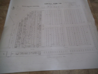 Rutherglen Historical Society
Carlyle Cemetery Map, Plan of Wesleyan Compartment, 1952
This is a map produced to attempt to bring order to the cemetery. Originally the layout was not well defined and it is difficult to use this plan to locate a particular grave, also the fact that not all graves are marked and foot paths are not defined has exacerbated this issue. Photocopy, White paper, black printing, black line work showing lot and compartment boundariesReferences Grid Survey points at 50 feet centres shown (as a cross with the reference mark number in brackets) Lot Number shown at left side of graves. Burial Number shown at right side of grave. Lots with unidentified burials show with dashed cross with in the lot. topographic survey, cadastral survey, carlyle cemetery, burials, graves, lot boundary, rotunda -
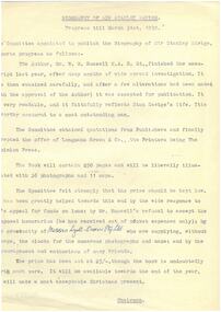 Melbourne Legacy
Letter - Document, letter, Biography of Sir Stanley Savige
Informs major stakeholders of the progress of the book up to 31 March 1959, a year after the author began work. Notes that the book will contain 250 pages, 36 photos, 11 maps and will cost 25/- per copy.Further details of the progress of the project to write a book about Stan Savige.Two typewritten/printed quarto sheets, one on plain paper and the other on blue letterhead, black on white.Draft: "Messrs Lyell-Owen Pty Ltd" handwritten in blue ink in #5. Letterhead: "Copies sent by Govan Cox to:- Main Committee Members, All Donors" pencilled in below the letterheading.savige book, biography -
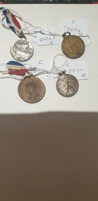 Colac RSL Sub Branch
Medal - Medals x 4, a) Centenary of Melbourne medal. b) Borough & Shire of Colac. 1945 Peace & Victory Medal. c) Coronation Medal 1937. d) Victory Medal 1945, NK
Commemorative medallionsmediumRound commemorative medals x 4. a) Silver coloured medal with a with Red, white and blue ribbon. b) Bronze coloured medal. No ribbon c) Bronze " " with a red, white and blue ribbon d) Silver " " . No ribbon a) Front:- Centenary of Melbourne. 1932. Man looking at city skyline. 1835. Back:- Centenary of Victoria. 1934. Sailing ship/shoreline. 1834 b) Front:- Borough & Shire of Colac. Coat of Arms surrounded by wreath and crossed swords. Back:- Peace and Victory. Surrounded by a wreath c) Front:- King George VI & Queen Elizabeth. Portraits of King and Queen Back:- To Commemorate their Majesties' Coronation d) Front:- Man with a sword on a map of Australia. 1945 Back:- Map -
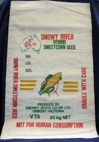 Orbost & District Historical Society
seed bag
This unused bag would have been used by Snowy River Co-Op Ltd to pack sweet corn in the late 1960's -1980's Snowy River Seeds started life as a farmers' co-operative (Snowy River Co-op) in 1967 specialising in horticulture. Snowy River Co-op were the original creators of Snowy Seeds.This item is significant because it was specially made for the seed bean industry which is a major industry in the Orbost district.A white synthetic woven fibre bag used to pack sweet corn prior to sale. It has red, green, yellow print.On front of bag - Logo of Man From Snowy River in outline map of Australia with a hand holding corn cob in the centre, Produce of Snowy River Co-Op Ltd Orbost- Victoria V73 25kg NETsweet-corn seed-bags snowy-river-co-op -
 National Vietnam Veterans Museum (NVVM)
Clothing - Child's jacket, August 1969
Bought by Phil Rogers, Australian Army no. 2790936 during his time of service in South Vietnam (1969-1970) to celebrate the birth of his son.Donated to the museum by the serviceman himself. This commemorative jacket demonstrates the poignant personal sacrifices made by those in service as significant family events continue at home in their absence.Child's bomber-style jacket made of khaki camouflage print polyester, hand embroidered. Purchased in South Vietnam in 1969 by Phil Rogers, Army No:2790936, B Company 6 RAR, and posted home on the birth of his son Brett 31/08/1969.Back: My daddy is in Vietnam/Vung Tau, 69-70/ Viet Nam plus a labelled map of Vietnam. Sleeves: Golden dragons Front: Tiger's head, Crossed South Vietnam flag and USA flag.commemorative clothing, children, family, vietnamese craft, craft, souvenir -
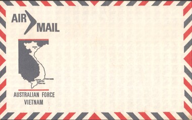 National Vietnam Veterans Museum (NVVM)
Ephemera - Envelope, Australian Army
Standard issue item as used by Australian servicemen during the conflict in Vietnam (1962-1972).Australian Force Vietnam Air Mail EnvelopeAir Mail Boomerang / Map of Vietnam / Australian Force Vietnam Red and blue colour strips for border around envelope. Back - Place for number/name/unit/AFPO...GPO Sydney N.S.W Australia 2890air mail, australian force vietnam, envelope, mail, letters -
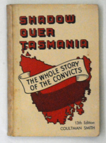 Orbost & District Historical Society
book, J. Walch & Sons Pty Ltd, Shadow Over Tasmania, 1961
This is the 13th edition. Beverly Coultman Smith was a newspaper reporter in Hobart, Tasmania, an A.I.F. officer in the Pacific War, a sub-editor, feature writer, magazine editor and a professional soldier specialising in public relations, staff, medals and records.This item is a useful reference tool for the convict history of Tasmania. A 150 pp paper back book with a cream cover. It is titled, "Shadow Over Tasmania" in red and black print. Diagonally across a map of Tasmania inside a banner is " "The Whole Story Of The Convicts".inside on title page is signature of the author, B. Coultman Smith.tasmania-history penal-colonies tasmania-history book-shadoww-over-tasmania smith-coultman-beverly -
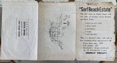 Phillip Island and District Historical Society Inc.
Booklet, Surf Beach Estate, About 1950
W. Davie was a local real estate agentHistoricalBooklet advertising the Surf Beach Estate . Large sheet printed on both sides. One side has map of the estate. other has information about estate, agent and location on Island" Surf Beach Estate" '"The only estate on Phillip island with two miles of Glorious Ocean Beaches and Rock Pools." Prices from only 250 pound.surf beach, real estate, w davie, town planning