Showing 22293 items
matching parks
-
 Eltham District Historical Society Inc
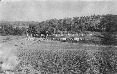
Photograph, Trestle Bridge, Eltham, c.1910
Most likely an F-Class 2-4-0 Steam Locomotive pushing carriage about to cross the Eltham Railway Trestle Bridge heading towards Greensborough, viewed from what was later Eltham Common and site of the re-located Shillinglaw Cottage (1964) and Eltham Library (1994). On the far side of the track on what is present day Central Park oval is a crop field. The railway was commenced in 1900 and passed through the middle of the Shillinglaw Farm. Here it passes through the farm paddocks. The train station at Eltham opened in 1902. Colour photocopy of original photo print (on loan?) 25.5 x 39 cm mounted on coreflutePencil mark at bottom "(c) 1910"eltham, trestle bridge, bridges, shillinglaw farm, f-class 2-4-0 steam locomotive, eltham railway trestle bridge, eltham trestle bridge, railway bridge, steam locomotive -
 Merri-bek City Council
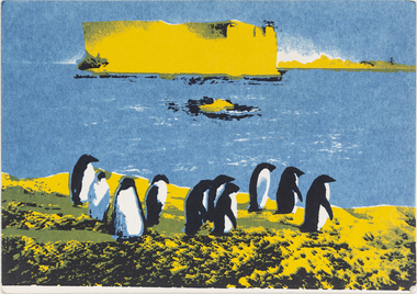
Work on paper - Screen print, Wendy Black, Declare Antarctica a World Park - Penguin, 1982
The 1980s saw a rise in campaigns for Antarctica to be designated a World Park. Black’s screenprints celebrate the creatures of the continent, however invocations such as ‘protect Antarctica from all mineral and oil exploration and exploitation’ remind the viewer that these creatures are in peril. Black printed 500 of these postcards (described as ‘Antarcticards’) at the Redletter Press in Brunswick and they were distributed around the world, reaching as far as Macquarie and Heard Islands. The campaigning was successful, with Australian Prime Minister Bob Hawke announcing that Australia would not support an agreement that would open the Australian Antarctic Territory up to mining and oil drilling.Donated by the artist8 prints in total -
 Merri-bek City Council
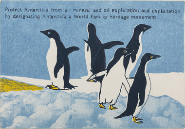
Work on paper - Screen print, Wendy Black, Declare Antarctica a World Park - Adelie, 1982
The 1980s saw a rise in campaigns for Antarctica to be designated a World Park. Black’s screenprints celebrate the creatures of the continent, however invocations such as ‘protect Antarctica from all mineral and oil exploration and exploitation’ remind the viewer that these creatures are in peril. Black printed 500 of these postcards (described as ‘Antarcticards’) at the Redletter Press in Brunswick and they were distributed around the world, reaching as far as Macquarie and Heard Islands. The campaigning was successful, with Australian Prime Minister Bob Hawke announcing that Australia would not support an agreement that would open the Australian Antarctic Territory up to mining and oil drilling.Donated by the artist8 prints in total -
 Royal District Nursing Service (now known as Bolton Clarke)
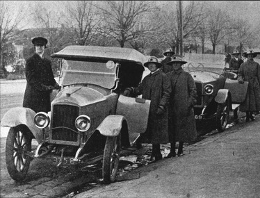
Photograph - Digital image, c.1922
The MDNS Trained nurses (Sisters) are about to board two motor vehicles outside their Nurses home, at 39 Victoria Parade, Collingwood, to be driven to give nursing care to their patients who lived a distance away. The lady Chauffeur is probably Miss Sword who was employed by MDNS in 1922-23; she was also in charge of the garage. This enabled the Sisters to do more visits in a day than when using Public transport all the time. This image also shows the style of cars driven in that era. The Sisters uniforms are grey and their hats have a red Maltese cross attached to the centre front of the hatband. Royal District Nursing Service (RDNS) has had various modes of transport over the last 130 plus years. At first, from 1885 as Melbourne District Nursing Society (MDNS), their Trained nurses (Nurses) walked the streets and lane ways amid the slums of central Melbourne. As the Society expanded public transport was used, and bicycles were bought by the Society in 1903 and used in inner areas until 1945. During the Spanish flu epidemic, in 1919, MDNS appealed for assistance to procure Motor vehicles so the Nurses could visit an influx of cases. Through trusts, grants and donations four 'Ford T Model' cars were procured which enabled the Nurses to triple their visits. Through constant use the cars were in such a poor state two were sold in 1922 and the others later. In 1922-23 three Peugeot cars were purchased and a female Chauffeur, 'Miss Sword', was employed who lived in the Home and was also in charge of the garage. MDNS was expanding, and In 1929 Melbourne District Nursing Society (MDNS) formed a volunteer Motor Auxiliary to transport their Trained Nurses (Sisters) to make visits more patients who lived a distance away. At first wealthy people offered their car and chauffeur, but then the general public supplied their own vehicles. They operated on week days when able and could take up to three Sisters at a time, collecting them from the Nurses Home, 39 Victoria Parade, Collingwood, at 9 a.m; dropping each Sister at a patient then picking them up and taking them to the next patient before completing the morning round and returning to the Nurses Home at 1 p.m.. The Sisters were able to double the number of visits they did each morning and did their afternoon visits on public transport. At its peak there were 60 volunteers but this fell off during World War 11. In 1944 the Red Cross were assisting, and by 1953 were taking out 16 MDNS Sisters. Appeals for volunteers occurred over the years, particularly during the Tram and Tramway Bus strike in the 1950s, and when the Royal Women's Hospital had an influx of births and wanted to send the mothers and babies home on day four but could not do so if M.D.N.S. could not visit. During 1962 the Motor Auxiliary transported 34 Sisters who preferred not to drive themselves, but as the MDNS fleet of cars grew there was less need for their service and the Auxiliary was disbanded in 1971. Some Sisters used their own cars; even a motorcycle was used by one Sister in 1933. All these forms of transport were intermingled and in the early 1950s, and now as Melbourne District Nursing Service, seven Ford Prefect cars were bought followed by twelve Ford Anglia cars 1955. Having received Royal patronage; the now Royal District Nursing Service (RDNS) had its own fleet of Holden vehicles by the mid 1960s and the Motor Auxiliary ceased operating in 1971 as by then all staff employed were required to have a driving licence. Seat-belts had been introduced to Victoria in 1959 and District fitted them to their cars from 1962, even though they did not become compulsory until 1970. The Holden vehicles were replaced with grey Holden Torana vehicles. After several years the fleet was changed to white Toyota Corolla vehicles. The Melways Directory of maps was introduced in 1966, which was a boon to the Sisters, though it was a few years before it went beyond Seville, so a large paper map was used by the Sisters visiting patients in the areas passed Seville. By 2009 there were 598 cars in the fleet and the Sisters travelled 9 million 200,000 kilometres – this is equivalent to 12 trips to the moon and back. IA black and white digital image showing, in the left foreground, the frontal view of an early model, 1920s, soft hooded car parked on the road next to the gutter. Two front spoked wheels are seen, and headlights sit either side of the radiator at the front of the nose shaped bonnet.. '3758' is written in white on the black number plate below the radiator. The female Chauffeur is dressed in a dark coat and peaked hat and is standing by the partly open driver's door. The passenger door is open and a Melbourne District Nursing Society (MDNS) Sister is standing on the footpath behind the door. Another Sister stands behind her. There is another similar car parked behind the first one. It is partly obscured, its hood is down; it has spoked wheels and one of its headlights can be seen beside the partially obscured radiator. Part of the black number plate can be seen with two of its numbers, '69', written in white. A partly obscured Sister is standing by the driver's door and another behind the open passenger door. Another Sister is standing at the rear of this car..The five MDNS Sisters are wearing their uniform grey coats and felt brimmed grey hats with a Maltese cross applied to the centre hatband, Leafless trees and some buildings can be seen in the background.melbourne district nursing society, after-care home, rdns, royal district nursing service, mdns motor auxiliary, mdns uniforms, miss sword, female chauffeur -
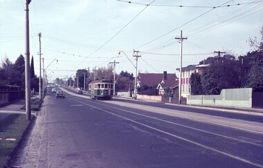
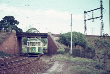 Melbourne Tram Museum
Slide - Set of 9, Keith Caldwell, 17/03/1966 12:00:00 AM
Set of 8 Agfa colour blue white plastic mount slides, photo by Keith Caldwell of trams on the Royal Park line in the vicinity of the Royal Park railway line. .1 - W2 328 (West Coburg Bell St route 55) passing under the railway bridge, with another W2 (362 or 382?) behind. Tram 328 has adverts for Remy Martin and Kleenex tissues. .2 - W2 521, route 55, passing a tram stop. Note the overhead light. .3 -W2 456, route 55 West Coburg via William St, passing under the railway bridge. .4 - not used, .5 - W2 355 with railway bridge in background, Domain Road, Route 56. .6 - W2 506 climbing the hill, Domain Road, route 55. Tram has adverts for White Crow tomato sauce. .7 - W5 812, arriving at stop (Section sign), to Carnegie, route 4. The tram stop has the fares to the city (15d and 7d). In the background is a Perway box. .8 - W2 227 (Domain Road route 56) with the railway station and two other trams in the background. .9 - SW6 (Route 55) outbound with the zoo walls in the background. Tram has advert for Coffey Ford. 17/3/1966In ink "17 iii 66"trams, tramways, royal park, route 55, west coburg, w2 class, domain rd, route 56, w5 class, sw6 class, tram 328, tram 521, tram 456, tram 355, tram 506, tram 812, tram 227, tram 913 -
 Melbourne Tram Museum
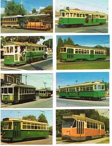
Photograph - Illustration/s, Melbourne & Metropolitan Tramways Board (MMTB), 1978
Set of eight of printed illustrations - postcard size of Melbourne and Metropolitan Tramways Board Tramcars produced in 1978. Separate card for each class of tramcar featured, with notes, statistics, MMTB name. Each card also has printers name and date on back. Not a formal postcard, no place for a stamp. 446.1 - Cable car set (No. 1) - photographed at Preston Workshops 446.2 - T 180 - showing "Special", while on a charter. 446.3 - X1 - 465 with 466 in background. Photographed at Footscray terminus, c1962. 465 has destination of "Ballarat Rd." 446.4 - Y 469 - showing destination of "Wattle Park - Elgar Road", possibly with Wattle Park in background. 446.5 - W2 511, showing destination of "City" and route 11. 446.6 - X2 676, showing "Special". 446.7 - W7 1022 - showing destination "West Preston", route 11, freshly painted. 446.8 - Z1 7 in Victoria Parade, c1975 - has destination of "West Preston - Regent St." and route number "13". 446.9 - L 104 on a route 67 Carnegie. 446.9 added 7/4/15, otherwise two copies of each held. 2nd copy of 446.9 added 28/5/2015. See Reg Item 994 for a packaged set of these photographs..trams, tramways, melbourne, mmtb, tramcars, tram 1, tram 180, tram 465, tram 466, tram 469, tram 511, tram 1022, tram 7, tram 104, z1 class, t class, x1 class, y class, w2 class, w7 class, l class, route 67, route 13, route 11 -
 Eltham District Historical Society Inc
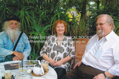
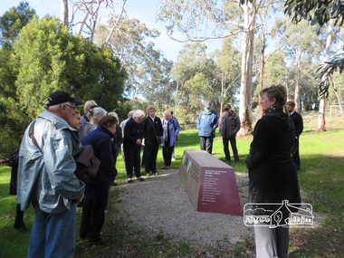
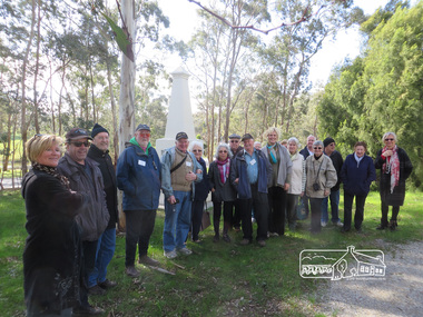
Photograph, Liz Pidgeon, Heritage Excursion; The 1901 Eltham Railway Walk, 3 May 2014, 3 May 2014
Football match at Eltham Central Park between Eltham and Heidelberg Newsletter No. 216, May 2014 May Excursion – The 1901 Eltham Railway Walk The railway from Heidelberg to Eltham was opened in 1902. Over the previous year railway construction cut a curving swathe through Josiah Holloway’s 1851 Little Eltham subdivision. The survey plans for the railway show the owners and occupiers of land within Little Eltham affected by the railway alignment and for some distance each side. The plans show houses and other buildings but development at that time was rather sparse. Copies of these plans from the State Library of Victoria collection have been provided to the Society by Alan Sheehan. For our walk on 3rd May we intend to follow the railway from the Eltham Station to Ryans Road, which was the boundary of the adjoining Montmorency Farm. The return will be by way of nearby streets. Along the way we will discuss the details shown on the railway plans as well as more recent railway documents and photographs. At the conclusion and if time permits we can inspect the historical display at the Eltham Station. The walk is about 3 km in length and will take about 2.5 hours. It will start at 2 pm at the Eltham Railway Station car park (east/Main Road side) (Melway Ref. 21 J5).Born Digitalheritage excursion, activities, eltham district historical society, eltham railway station, eltham library, trestle bridge, eltham central park, football -
 Cheese World Museum
Advertisement, Vickers Tractors
Vickers of Sheffield in England manufactured armaments in the WWI period. In the early 1920s commenced manufacturing tractors under license to International Harvester. This tractor was aimed at the Australian market and called the 'Aussie' with the first available in 1925 but lack of sales forced Vickers to abandon tractor manufacture by 1930. This advertisement is part of the Uebergang Collection of rural items given into the care of the Cheese World Museum. . The Uebergang family came from Silesia to Australia in 1848 and were early settlers in the Allansford area. The sons and other descendants also purchased farms in the area. The Percy Uebergang family lived at Tooram Park, Allansford from 1912 until 1992. Percy and Myrtle Uebergang's children were twins, Ray and Joyce born in 1926 who lived at Tooram Park until their deaths, Ray in 1986 and Joyce in 1992 after which the property was sold. Neither Ray nor Joyce married and following the death of her brother Joyce set up the Ray and Joyce Uebergang Foundation which supports the local community. The collection of items from their property was put into store for a number of years before being given into the care of the Cheese World Museum. The family often re-used, recycled and repaired items and examples can be seen in the museum. A4 size advertisement cut from a newspaper showing the Vicker's tractors new features and a drawing of the tractor.Built by Vicker's Ltd/Vicker's Tractors/And Now a Better Vickers than ever.allansford, vickers tractors, tractors, advertisements -
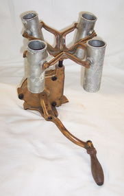 Cheese World Museum
Centrifuge, manual, c1890
The Uebergang family came from Silesia to Australia in 1848 and were early settlers in the Allansford area. The sons and other descendants also purchased farms in the area. The Percy Uebergang family lived at Tooram Park, Allansford from 1912 until 1992. Percy and Myrtle Uebergang's children were twins, Ray and Joyce born in 1926 who lived at Tooram Park until their deaths, Ray in 1986 and Joyce in 1992 after which the property was sold. Neither Ray nor Joyce married and following the death of her brother Joyce set up the Ray and Joyce Uebergang Foundation which supports the local community. The collection of items from their property was put into store for a number of years before being given into the care of the Cheese World Museum. The family often re-used, recycled and repaired items and examples can be seen in the museum. This Babcock tester is part of the collection of items given into the care of the Cheese World Museum. The Babcock tester was used to determine the butter fat content in milk. Prior to the use of the Babcock test farmers were paid on volume and milk was sometimes watered down to increase the supply to the factory. Once the Babcock test was introduced it provided a consistent means of paying farmers for milk supplied to the factory. The Babcock tester is significant as a scientific means of testing fat content of milk and the subsequent consistent payment mechanism to farmers. This test also provided a means for farmers to identify poor performing cows and upgrade the quality of their herd and subsequent milk supply to the factory.Four tipping metal testing tubes which revolve on a brass base. A winding handle has a wooden grip. The base and arms holding the metal tubes is painted red.OFFICIAL BABCOCK TESTERallansford, dairy farming, dairy industry, dairy processors, babcock test -
 Flagstaff Hill Maritime Museum and Village
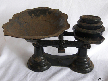
Instrument - Balance Scale, Henry Crane (Crane Foundry), 1870-1900
The Crane foundry opened some time before 1827 and was known as Atherton’s Foundry, run by James Atherton and Henry Crane. Initially it was a brass foundry, but by 1827 iron castings were also produced on the site. The main products were castings for the building industry, ironmongery and brassware. In the 1830s castings for the hand tool and lock industries were added to the product range and by 1836 Henry Crane had taken control of the business. The company became known as the Crane Foundry in 1847 with its own registered trademark. By the 1850s iron weights were produced, and a design was registered in 1872 with roundels decorating the edge. Brass weights were also produced, mainly after the regulation of 1890 that required weights of 2oz. or less to be made of brass. In the early 1900s the foundry began to produce castings for electric motors and continued to do so throughout its life. The Crane family continued to control the company until 1917 when William Cyril Parkes of lock makers Josiah Parkes & Sons Limited, Willenhall became a majority shareholder. Things were going well until the company’s liabilities spiraled out of control with the rise in electricity and gas prices along with the loss of two of the company’s largest customers. The factory went into liquidation and then closed in 2006 an end to one of Wolverhampton’s oldest companies.An item made by one of England's foundry’s based in Wolverhampton that exported items all over the world for many years. The scale gives a snapshot into the commercial life not only of England by Australian colonial life before Federation.Beam scale with three weights (4lb, 2lb, 1lb), metal tray, corrodedMarked on 2lb weight "Wolverhampton Crane Foundry" flagstaff hill, warrnambool, flagstaff hill maritime museum, shipwreck coast, flagstaff hill maritime village, great ocean road, scale, beam scale, pounds and ounces, imperial weight, grocers scale, domestic scale, henry crane, crane foundry -
 Melbourne Tram Museum
Album - Robert Thomson Slide Collection, "Melbourne 1965 April Box 1"
Photo - see pdf file for further information. Number Brief Description RT107 Whitehorse Road - tram 378 - "City" - route 42 RT108 Malvern Depot - tram 947 - "Malv Tn Hall" - route 6B RT109 tram 7 RT110 tram 7 RT111 North Fitzroy - tram 980 - East Brunswick - Blyth St - route 96 RT112 North Fitzroy - tram 980 - East Brunswick - Blyth St - route 96 RT113 Hawthorn Depot - tram 17 RT114 Location ? tram 471 - "City" - route 7 RT115 Deepdene - tram 848 - "City" - route 42 RT116 Wattle Pk Ter - tram 368 - "City" - route 70 RT117 East Brighton Ter - tram 105 - "East Brighton via Caulfield" - route 64 RT118 Simpson St Siding - tram 889 - "Spencer St" - route 48 & tram 249 -"Football" RT119 Swan St Relay - tram 517 - "Wattle Park Elgar Rd" - route 70 RT120 tram 401 - "City" - route 70 - Swan St RT121 tram 401 - "Wattle Park Elgar Rd" - route 70 - Swan St RT122 tram 330 - "City" - route 70 - Swan St Demonstrates the work of Robert Thomson in photography, collection and/or production of slidesAssembled album in a black presentation folder of 16 colour slides, collected or produced by Robert Thomson. All photographs have been scanned and placed on the Museum's G drive. A list of all photographs with details has been compiled. melbourne, tramways, trams -
 Ringwood and District Historical Society
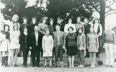
Photograph, Ringwood State School - Teachers, 1971
Black and white photograph - Teachers, 1971."Attached to photograph" Back Row- L to R: Leslie Emerson, Joy Leslie, Amy Douglas, Martha Celnar, Gwen Whitney, Ann Jacobs, Joan Mathey, Isobel Marshall, Maureen Keogh, Jennifer Molders. Front Row- L to R: Baden Chadwick, Bernadette Martyn, Rae Jacobsen, Jeanette Parks, Alex Enterkin, Miss O'Toole, Randall Smith, Jean Watson, Joan Hallett, Anne Schneider, John Roach. -
 Ringwood and District Historical Society
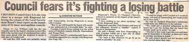
Newspaper, Scrapbook Clipping, Library Collection, Ringwood, Victoria, `
``Newspaper clipping from "The Mail" 8 -6- 94 P1 - Council fear's it's fighting a losing battle by Christine McTigheCroydon Council fears it is one step closer to a merger with Ringwood following the release of the Local Government Board's final report on the boundaries of 21 inner metropolitan councils. Croydon Mayor Cr Les Wilmott favors taking over the urban areas of Lilydale, namely Kilsyth, Mooroolbark and Wonga Park. The council fears that the Board has made up its mind to a merger between Croydon and Ringwood, which the councils don't want.` -
 Ringwood and District Historical Society
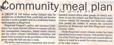
Newspaper, Scrapbook Clipping, Library Collection, Ringwood, Victoria
Newspaper Clipping from "The Post", 12 May 1993, Page 7, "Communiy meal plan"'.A group of 140 Italian senior citizens may be granted use of Bedford Park youth hall and kitchen one day a week to prepare and eat a traditional Italian meal together in Ringwood. Ringwood Council's policy and resources committee directed officers to consult with the hall management committee, Italian senior citizens and the senior citizens' consultative committee and report back to council on the possibility of the Italian group using the hall one day a week. -
 Eltham District Historical Society Inc
Photograph - Digital Photograph, Marguerite Marshall, Stuchbery Farm dairy, 14 March 2008
Stuchbery Farm was situated on the Plenty River bounded by Smugglers Gully to the north and La trobe Road, Yarrambat, to the east. Alan and Ada Stutchbery moved to the valley in 1890, first living in a tent where four children were born. Alfred built a home and outbuildings around 1896. They planted an orchard, then a market garden and developed a dairy. Published: Nillumbik Now and Then / Marguerite Marshall 2008; photographs Alan King with Marguerite Marshall.; p179 The dramatic steep-sided Plenty Gorge lies along the divide of two geological areas, and separates the Nillumbik Shire and the City of Whittlesea. On the Nillumbik side are undulating hills and sedimentary rock, and in Whittlesea, lies a basalt plain formed by volcanic action up to two million years ago. This provides the Plenty Gorge Park with diverse vegetation and habitats, making it one of Greater Melbourne’s most important refuges for threatened and significant species. The park, established in 1986, consists of around 1350 hectares, and extends 11 kilometres along the Plenty River, from Greensborough to Mernda. It provides a wildlife corridor for around 500 native plant and 280 animal species. The area’s plentiful food and water attracted the Wurundjeri Aboriginal people and then European settlers. By 1837 squatters had claimed large runs of land for their sheep and cattle. The Plenty Valley was among the first in the Port Phillip District to be settled - mainly in the less heavily timbered west - and was proclaimed a settled district in 1841. But by the late 1880s, the settlers’ extensive land clearing for animal grazing, then agriculture, depleted the Wurundjeri’s traditional food sources, which helped to drive them away. Many Wurundjeri artefacts remain (now government protected), and so far 57 sites have been identified in the park, including scarred trees, burial areas and stone artefacts. Pioneer life could be very hard because of isolation, flooding, bushfires and bushrangers. Following the Black Thursday bushfires of 1851, basalt was quarried to build more fire-resistant homes. Gold discoveries in the early 1850s swelled the population, particularly around Smugglers Gully; but food production made more of an impact. In the late 1850s wheat production supplanted grazing. In the 1860s the government made small holdings available to poorer settlers. These had the greatest effect on the district, particularly in Doreen and Yarrambat, where orchards were established from the 1880s to 1914. Links with a prominent early family are the remains of Stuchbery Farm, by the river’s edge bounded by Smugglers Gully to the north and La Trobe Road, Yarrambat, to the east. The Stuchberys moved to the valley in 1890, and the family still lives in the area. In 1890, Alfred and Ada first lived in a tent where four children were born, then Alfred built the house and outbuildings around 1896. They planted an orchard, then a market garden, and developed a dairy. The family belonged to the local Methodist and tennis communities. Their grandson Walter, opened the Flying Scotsman Model Railway Museum in Yarrambat, which his widow, Vi, continues to run. Wal was also the Yarrambat CFA Captain for 22 years until 1987. Walter sold 24 hectares in 1976 for development - now Vista Court - and in 1990, the remaining 22.6 hectares for the park. Remaining are an early stone dairy and remnants of a stone barn, a pig sty and a well. Until it was destroyed by fire in 2003, a slab hut stood on the Happy Hollow Farm site, at the southern end of the park. The hut is thought to have been built in the Depression around 1893. This was a rare and late example of a slab hut with a domestic orchard close to Melbourne. Emmet Watmough and his family first occupied the hut, followed by a succession of families, until the Bell family bought it around 1948. There they led a subsistence lifestyle for 50 years, despite encroaching Melbourne suburbia. The Yellow Gum Recreation Area includes the Blue Lake, coloured turquoise at certain times of the year. Following the 1957 bushfires, this area was quarried by Reid Quarries Pty Ltd for Melbourne’s first skyscrapers, then by Boral Australia. However in the early 1970s water began seeping into the quarry forming the Blue Lake and the quarry was closed. The State Government bought the site in 1997 and opened it as a park in 1999.This collection of almost 130 photos about places and people within the Shire of Nillumbik, an urban and rural municipality in Melbourne's north, contributes to an understanding of the history of the Shire. Published in 2008 immediately prior to the Black Saturday bushfires of February 7, 2009, it documents sites that were impacted, and in some cases destroyed by the fires. It includes photographs taken especially for the publication, creating a unique time capsule representing the Shire in the early 21st century. It remains the most recent comprehenesive publication devoted to the Shire's history connecting local residents to the past. nillumbik now and then (marshall-king) collection, ada stuchbery, alan stuchbery, dairy, stuchbery farm, farm buildings, yarrambat, plenty gorge park -
 Eltham District Historical Society Inc
Photograph, Fay Bridge, Book launch of Laughing Waters Road by Jane Woollard at Montsalvat, Eltham, 30 January 2016
Laughing Waters Road , the book was launched at Montsalvat in Eltham. On Saturday, January 30, 2016, Nillumbik Council launched this book. The weather was cool; just as well, considering over 500 people attended this very pleasant event where food and drink were plentiful. The Australian Government and Nillumbik Shire Council funded the book and it was designed by Wayne Rankin of North Warrandyte. The dedication page is to our very own Ranger Campbell Beardsell OAM of Parks Vic who taught Jane to be “passionate about the environment of this special place” (p260). FOWSP members Val Polley, Linda Rogan and Ken Crook contributed to the content and photos. David Wandin, Wurundjeri Elder, gave a Welcome to Country and officially launched the book after the Mayor of Nillumbik, Cr Hattam, made introductions. Jane Woollard followed with a brief outline of how she came to write the book (her very first) and read out loud the last paragraph which focuses on reconciliation and shared culture. Jane declared in her preface that the book “has been formed by attending to the connection between rivulets of memories, creeks of hearsay, rivers of tales, the meanders of local legend and the deep, still pools of the archive.” Very poetic! - Lynda Gilbert Newsletter; Friends of Warrandyte State Park March 2016, Volume 34 Number 2 Laughing Waters Road , the book was launched at Montsalvat in Eltham ON SATURDAY 30 JANUARY Nillumbik Council launched this book. The weather was cool; just as well, considering over 500 people attended this very pleasant event where food and drink were plentiful. The Australian Government and Nillumbik Shire Council funded the book and it was designed by Wayne Rankin of North Warrandyte. The dedication page is to our very own Ranger Campbell Beardsell OAM of Parks Vic who taught Jane to be “passionate about the environment of this special place” (p260). FOWSP members Val Polley, Linda Rogan and Ken Crook contributed to the content and photos. David Wandin, Wurundjeri Elder, gave a Welcome to Country and officially launched the book after the Mayor of Nillumbik, Cr Hattam, made introductions. Jane Woollard followed with a brief outline of how she came to write the book (her very first) and read out loud the last paragraph which focuses on reconciliation and shared culture. Jane declared in her preface that the book “has been formed by attending to the connection between rivulets of memories, creeks of hearsay, rivers of tales, the meanders of local legend and the deep, still pools of the archive.” Very poetic! - Lynda Gilbert Newsletter; Friends of Warrandyte State Park March 2016, Volume 34 Number 2 https://fowsp.org.au/docs/News_2016/34_02_March.pdffay bridge collection, 2016-01-30, book launch, bronnie hattam, jane woollard, laughing waters road, montsalvat, sigmund jorgensen, harry gilham, maurice hurry -
 Glen Eira Historical Society
Document - Glen Eira Residents Association
... Parks ...Six items pertaining to Glen Eira Residents Asssociation Inc. 1/Two copies of the minutes of a Committee Meeting of Glen Eira Residents Association Inc., held on 04/12/2001. The minutes cover a range of routine meeting items, as well as the postponed release of the Princes Park Master Plans and the proposed construction of car parks at Caulfield Racecourse. 2/A copy of Glen Eira Residents’ Association Inc.’s 30/05/2003 newsletter, notifying members of matters presently before Glen Eira City Council for purposes of evaluation. Matters include an admonishment to the Council to sort out anomalies between the C25 Amendment (80/20 Plan) and the Melbourne 2030 Plan, the success at convincing the Ministerial panel to adopt GERA’s views regarding the C14 Council Plan for the Caulfield Racecourse, a request for information from the Council regarding the previous year’s rate increase, a request for information from the Council regarding spending on planning for improvements to Princes Park, a call for the Council to improve its consultative procedures, a recommendation that the purpose of Glen Eira News be expanded to the making of suggestions for city improvement, and a notification of the measures implemented to improve the visibility of Caulfield Racecourse’s usability by the public. Includes a black-and-white photograph of Orrong Road, Elsternwick, illustrating what Glen Eira’s roads would look like if lined with trees, which was excluded from Glen Eira News on account of a current prohibition on the making of suggestions for city improvements. 3/Four copies of a booklet entitled ‘A Short Guide to Planning Procedures’, composed 08/2006, which endeavours to explain, as concisely as possible, the methodology by which Glen Eira City Council approves real estate developments and issues planning permits. 4/A booklet containing the minutes of the 05/10/2009 Annual General Meeting of Glen Eira Residents’ Association Inc. Details both routine items and more specific matters of discussion, such as inappropriate charges on the part of the Glen Eira City Council and the proposed inception of a questionnaire to evaluate local residents’ opinion of the Council. 5/A booklet announcing the 07/10/2010 Annual General Meeting of Glen Eira Residents’ Association Inc. at St. John’s Uniting Church, Elsternwick. Front cover details agenda and contains four colour photographs pertaining to public transport (buses, trams, trains) within the city. Interior features president Don Dunstan reflecting on issues relevant to GERA occurring over the preceding twelve months, with an emphasis on the dubious behaviour of the City Council, as well as two colour photographs: one of Dunstan himself and one of traffic at Elsternwick Junction. The rear cover contains the Financial Statement presented to the Meeting. 6Two copies of a printout of an article from the website of Glen Eira Residents’ Association Inc., accessed 19/06/2012, explaining the affects wrought as a result of the implementation of Planning Scheme Amendment C87. Said amendment changes the Planning Scheme protecting neighbourhood character by replacing the previous Significant Character Area (SCA) designation with the new designations of Neighbourhood Character Overlay (NCO) and Design and Development Overlay (DDO). In developing the Amendment, Glen Eira City Council commissioned Planisphere to procure the Planisphere Final Report, in which recommendations regarding the expansion, creation and deletion of SCAs were offered. The article contains a summary of said recommendations.glen eira residents’ association inc., clubs and associations, glen eira, meetings, minutes, campbell jack, dunstan don, marwick geoff, pleydell max, teseriero dominic, robins kevin, princes park, south caulfield, glen eira city council, local government, councillors, brennan martin, victorian local government association (vlga), erlich mayor, project manikato, caulfield racecourse, caulfield racecourse flat, racecourses, parks, car parks, kennedy cr., kennedy norman mr., crown land, glen eira road, rippon lea, c25 plan (80/20), melbourne 2030 plan, c14 council plan, rates, orrong road, elsternwick, trees, station street, caulfield north, neerim road, glenhuntly, glenhuntly park, orrong ward, grossbard cr., martens cr., building permits, delegated planning committee (dpc), steward joy, brohier peter, campbell fliss, scutt alex, ray darren, hannah brian, st. john’s uniting church, mees paul dr., elsternwick club, sandham street, melbourne weekly bayside, glen eira debates, walsh investigation, whelen investigation, forge cheryl cr., whiteside helen mayor, save our suburbs (sos), walsh mary, walsh kevin, french christine, elsternwick junction, planning scheme, planning scheme amendment c87, significant character areas (scas), planisphere final report, oakdene crescent, carnegie, blackwood street, housing diversity areas, urandaline grove, caulfield, normanby road/park crescent, kambrook road, balaclava road, hawthorn road tramway estate, caulfield south, ulupna road, ormond, murray street, prentice street, kambea grove, chestnut street, mcpherson avenue, queens avenue, caulfield east, derby crescent, clarinda street, st. james parade/downshire road, exhibition street, mckinnon, field street, boyd park, murrumbeena, lindsay avenue, lydson street -
 The Beechworth Burke Museum
Photograph, 1960s
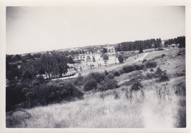
This photo was taken in the 1960s from a northeast position looking down towards Lake Sambell, the caravan park, and the surrounding area. This photo was taken during a period of rejuvenation for the lake area including the opening of the caravan park in 1959 and the swimming pool area in 1961 (this pool is just visible in the centre of the photo). The popularity of caravanning in Australia exploded during this post-war period of the late 1950s and 1960’s. This popularity was driven by multiple factors, including: the stopping of fuel rations, the accessibility of car ownership through the manufacturing of affordable cars, technological developments in caravan design, and the increase in prosperity and leisure time for many Australians. Lake Sambell is an artificial lake that was developed on the previous site of the Rocky Mountain Mining Company workings and was officially opened by Minister for Lands, Mr Baily, on October 5, 1928. The disused and unattractive remains of the mine were converted into a recreational area intended for swimming, boating, and fishing. The lake is named after Mr L.H. Sambell, shire engineer and secretary of the Forward Beechworth Committee, who advocated for the enhancement of Beechworth into a tourist destination and was central to the planning and establishment of the lake. Funding for the project was raised by both competition funds and donations. Since the construction in 1928 several engineering issues have arisen. In 1939 the water levels were low, and the lake was considered both an eyesore and ‘mudhole’, Beechworth Shire Council sort funding to raise the height of the lake six feet to improve the quality of water. Throughout the 1940s the Beechworth Swimming Club tried to raise awareness and funds to address the structural engineering issues and improve swimming facilities at the lake. R.E. Carter, similar to L.H. Sambell, was a shire engineer who advocated the importance of positioning Beechworth as a tourist destination. Carter held the position from 1954-63 and organised many improvements to the Lake Sambell area including the caravan park in 1959, the lake swimming pool in 1961, water skiing and boating facilities, and increased the lake surface are in 1964. These improvements were financed mainly by grants from the Tourist Development Authority. This photograph is of historical significance as it documents Lake Sambell and the surrounding area in the 1960s after a phase of enhancements to improve the appearance and usability for both the people of Beechworth and tourists. It is also of social significance in providing an insight into the increase in leisure time and access to travel during a period of post-war prosperity.Black and white rectangle photograph printed on matte photographic paper and unmounted.Reverse: 1 / [logo KODAK/ VELOX/ PAPER] / C798 / 3535lake sambell, lake sambell caravan park, lake sambell swimming pool, caravan park, caravanning 1960s, rocky mountain mining company, l.h. sambell, r.e. carter, beechworth swimming club, forward beechworth committee, minister of lands, tourist development authority, lake swimming, swimming, boating, fishing, water skiing, beechworth 1960s, lake sambell fishing, lake sambell boating -
 Eltham District Historical Society Inc
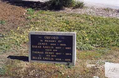
Negative - Photograph, Harry Gilham, Orford family graves, Eltham Cemetery, Victoria, Sep 2009
One of Eltham's earliest settlers was James Orford. Born 1804 in Bedfordshire, the son of George, a carpenter and Lydia Barret, he and wife Sarah Amelia nee Moull (1807) arrived as Assisted Immigrants aboard the ship, ‘Orestes’, November 28, 1839 accompanied by their children, George (14), Mary Ann (11), and James (2). Originally settling in New South Wales, daughter Sarah Amelia was born at Braidwood in 1843 and son, Thomas Henry at Pambula in 1847. James was a carpenter who is known to have built the original gates to Eltham Cemetery. He died in 1869. Around 1890, his son Thomas Henry Orford was living in Pitt Street. Following the death of his wife Helen in 1899, Thomas was appointed by Joseph Panton to look after ‘Panton Park’, a 429-acre bushland property at the fork of Reynolds and Laughing Waters Roads, extending down to the Yarra River. His work entailed ringbarking the manna gums on the property to clear the land for pasture. Thomas lived in a slab hut with his son Ernie, who helped with the work. When Gordon Lyon purchased Panton Park in 1908, Thomas then worked for Lyon at both Panton Park and at ‘Banyule’, Lyon's stud farm at Heidelberg. In 1915 Lyon gave Thomas six acres of land in Reynolds Road with a two-roomed cottage. Thomas died in 1944 and is buried in Eltham Cemetery with his wife and his parents. Another of James Orford's sons was James Matthias Orford. He tried to grow food on land at the end of Laughing Waters Road, but without success. Reputedly the Wurundjeri taught him to swim. He was once imprisoned; when his friend Constable Lawlor invited him to inspect the new bluestone lock-up, Lawlor locked him in and wouldn't release him until he was promised two gallons of beer! ORFORD In Memory Of James 1804 -1869 Sarah Amelia 1807 - 1897 Their son Thomas Henry 1847 - 1944 His wife Helen Amelia 1854 - 1899Roll of 35mm colour negative film, 6 stripsKodak GC 400-9eltham cemetery, gravestones, helen amelia orford, james orford, sarah amelia orford, thomas henry orford, cemetery gates -
 Eltham District Historical Society Inc
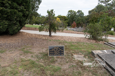
Photograph, Peter Pidgeon, Orford family graves, Eltham Cemetery, Victoria, 5 April 2021
One of Eltham's earliest settlers was James Orford. Born 1804 in Bedfordshire, the son of George, a carpenter and Lydia Barret, he and wife Sarah Amelia nee Moull (1807) arrived as Assisted Immigrants aboard the ship, ‘Orestes’, November 28, 1839 accompanied by their children, George (14), Mary Ann (11), and James (2). Originally settling in New South Wales, daughter Sarah Amelia was born at Braidwood in 1843 and son, Thomas Henry at Pambula in 1847. James was a carpenter who is known to have built the original gates to Eltham Cemetery. He died in 1869. Around 1890, his son Thomas Henry Orford was living in Pitt Street. Following the death of his wife Helen in 1899, Thomas was appointed by Joseph Panton to look after ‘Panton Park’, a 429-acre bushland property at the fork of Reynolds and Laughing Waters Roads, extending down to the Yarra River. His work entailed ringbarking the manna gums on the property to clear the land for pasture. Thomas lived in a slab hut with his son Ernie, who helped with the work. When Gordon Lyon purchased Panton Park in 1908, Thomas then worked for Lyon at both Panton Park and at ‘Banyule’, Lyon's stud farm at Heidelberg. In 1915 Lyon gave Thomas six acres of land in Reynolds Road with a two-roomed cottage. Thomas died in 1944 and is buried in Eltham Cemetery with his wife and his parents. Another of James Orford's sons was James Matthias Orford. He tried to grow food on land at the end of Laughing Waters Road, but without success. Reputedly the Wurundjeri taught him to swim. He was once imprisoned; when his friend Constable Lawlor invited him to inspect the new bluestone lock-up, Lawlor locked him in and wouldn't release him until he was promised two gallons of beer! ORFORD In Memory Of James 1804 -1869 Sarah Amelia 1807 - 1897 Their son Thomas Henry 1847 - 1944 His wife Helen Amelia 1854 - 1899Born Digitaleltham cemetery, gravestones, helen amelia orford, james orford, sarah amelia orford, thomas henry orford -
 Eltham District Historical Society Inc
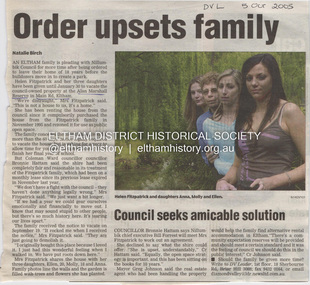
Document - Property Binder, 1225 Main Road, Eltham
Newspaper article: Order upsets family, Diamond Valley Leader, 5 October 2005, Helen Fitzpatrick ordered to vacate Nillumbik Council owned property at Alan Marshall Reserve for creation of a park. Newspaper article: Nature calls again for a real blessing, Diamond Valley Leader, 5 October 2005, St Margaret's Anglican Church to hold annual blessing of the animals service. Newspaper article: Family gets council reprieve on house until 2007, Diamond Valley Leader, 12 October 2005, Helen Fitzpatrick permitted to remain at property until 2007.main road, eltham, helen fitzpatrick, anna fitzpatric, molly fitzpatrick, ellen fitzpatrick, alan marshall reserve, bronnie hattam, bill forrest, greg johnson, libby delbridge, st margaret's anglican church eltham, gordon roberts -
Glen Eira Historical Society
Article - Pearson, William
Four items related to Pearson family. 1.Brief photocopied item giving details relating to William’s pastoral estates. Political arenas he was involved with his business interests including his breeding of race horses, including handwritten note about his champion racehorse, date and author unknown. 2.Handwritten page on the details of his family burial plots at Brighton cemetery, date and author unknown. 3.Handwritten rate book listings from 1876 to 1891, date and source unknown. 4.3 copies of Heraldic sketches pertaining to the Pearson of Kilmany Park and Craigellachie in Scotland.pearson william, ‘craigellachie’, ‘kilmany park’, housenames, pioneers, travers eliza laura, orrong rd, magistrate, studs, mine owners, mansion, long tunnel gold mining co., pearson hugh, pearson henry travers, pearson william jr, inkerman street -
 Eltham District Historical Society Inc
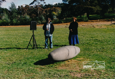
Photograph, Not Just a Pretty Place, Aleks Danko (2000), Lennister Farm, Eltham South, 2000c
The sculpture was launched on 9th August 2000 by Cr Diane Bullen and welcomed by Annette Xiberras of the Wurundjeri community. Not Just a Pretty Place acknowledges the cultural significance of this site for the residents of Nillumbik Shire and for the Wurrundjeri community. Historically the confluence of rivers have particular importance as these were sites where rituals and ceremonies took place. The carved bluestone form presents an oversize river pebble that echoes the spirit of the water and draws attention to this location as a meeting place an landmark. Awarded the 2000 Nillumbik Art in Public Places Award and situated behind Lennister Farm near Yarra ParkColour photograph printaleks danko, eltham, lennister farm, yarra park, cr. diane bullen -
 Federation University Historical Collection
Book - Exhibition Catalogue, Arts Society Catalogue 2019, Bachelor of Visual Arts, 2019
Pages feature student works, contacts and artist statements. Introduction by Alexandra Twaddle, President of the Art Society, 2019. "Featured Artists" / Students: Paul Justin Butler, Jessica Condemi, Veronica Drum, Marian Fox, Suzanne Hilton, Shaye Leathan, Ebony Leslie, Shelly May, Tess O'Keefe, Maggie Parkes, Chandler Pearce, Rachel Power, Stephany Renfrew, Lizzie Tonway, Kirsty Tonkin, Alexandra Twaddle. Inside last page thanks: Elke Varga, Jimmy Pasakos, Peter Pilven, Roberta Crisci-Richardson, Peter Gaulke, Phil Berry, Debbie Hill and Claire Blake. Catalogue to accompany the Federation University, Bachelor of Visual Arts graduate exhibition, 2019. 36pp + 4pp cover perfect/burst bound book. Single colour black print on raw card cover, full colour inside pages.federation university, visual arts, arts academy, camp street campus, exhibition, eye, end of year, end of year exhibition, paul justin butler, jessica condemi, veronica drum, marian fox, suzanne hilton, shaye leathan, ebony leslie, shelly may, tess o'keefe, maggie parkes, chandler pearce, rachel power, stephany renfrew, lizzie tonway, kirsty tonkin, alexandra twaddle. -
 Greensborough Historical Society
Photograph - Digital Image, Pioneer Reserve 2014 -1, 21/05/2014
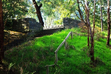
Pioneer Reserve, Greensborough is a small park on the corner of St Helena and Diamond Creek Roads. It is adjacent to the site of Greensborough's first bridge across the Plenty River, c. 1864 - 1960s. The shelter, viewing platform, retaining wall and entrance are built from the bridge's massive bluestone arched abutments dismantled between 1974 and 1983. Pioneer Reserve is historically significant for its formative association with noted local landscape designer Gordon Ford in 1968, and it is likely that remnant large field stones at the entrance drive to the Reserve remain from his design. Photograph by Marilyn Smith 2014.Digital copy of colour photograph. -
 Eltham District Historical Society Inc
Photograph, Shire of Nillumbik World War One Memorials tour, 10 August 2016, 10 August 2016
As part of a program to acknowledge the Anzac Centenary Nillumbik Shire Council partnered with Yarra Plenty Regional Library to provide a bus tour with commentary of local sites of significance. These included Eltham township, the Shire of Eltham War Memorial at Kangaroo Ground, Christmas Hills war memorial, Hurstbridge memorial recreation park and finshed at Eltham Library to view the Writing the War exhibtion at Eltham Library Community Gallery. In May 2015 Nillumbik Shire Council received Anzac Centenary Local Grants Program funding for the restoration and enhancement of the Christmas Hills cenotaph as a project to commemorate the First World WarBorn Digitalworld war 1, war memorials, shire of nillumbik, christmas hills, tour, interpretative signage -
 Eltham District Historical Society Inc
Photograph, Shire of Nillumbik World War One Memorials tour, 10 August 2016, 10 August 2016
As part of a program to acknowledge the Anzac Centenary Nillumbik Shire Council partnered with Yarra Plenty Regional Library to provide a bus tour with commentary of local sites of significance. These included Eltham township, the Shire of Eltham War Memorial at Kangaroo Ground, Christmas Hills war memorial, Hurstbridge memorial recreation park and finshed at Eltham Library to view the Writing the War exhibtion at Eltham Library Community Gallery. In May 2015 Nillumbik Shire Council received Anzac Centenary Local Grants Program funding for the restoration and enhancement of the Christmas Hills cenotaph as a project to commemorate the First World War Born Digitalworld war 1, war memorials, shire of nillumbik, christmas hills, tour, cenotaph, group -
 Orbost & District Historical Society
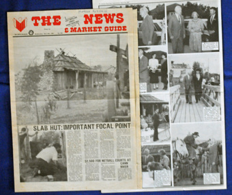
newspaper clippings, April, May 1987
The Slab Hut (Orbost Visitor Information Centre) was opened on March 28, 1987. It was officially opened by Dr D. Caughey, the governor of Victoria. The Orbost Visitor Information Centre is situated in Forest Park on Nicholson Street. The centre is housed in the historic Slab Hut. The hut was an original family dwelling built in 1872, on a site approximately three kilometres upstream from the junction of the Buchan and Snowy Rivers. The Hut was removed from its original site around 1970, and stored until 1984 when the Shire Council approved the current site. It was restored and brought to life as a Tourist Information Centre in 1987.The Slab Hut is an icon of Orbost. These newspaper articles are contemporary records of the opening of this building.A selection of articles from The News and the Snowy River Mail. All relate to the opening of the Slab Hut, the Orbost Visitor Information Centre. They are photographs, information and the history of the Slab Hut.slab-hut-orbost newspaper-snowy-river-mail -
 Eltham District Historical Society Inc
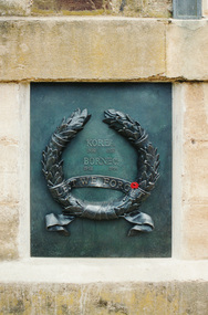
Photograph, Bronze plaque for the Korea (1950-1953) and Borneo (1962-1966) conflicts, War Memorial Tower, Kangaroo Ground
Harry Gillham, President and EDHS and Convenor of the Nillumbik Shire Council's Advisory Committee for the War memorial at Kangaroo Ground was for some years working on the refurbishment of the Tower of Rememberance and the surrounding park. The Committee decided to produce plaques to commemorate the armed conflicts in Korea, Malaysia, Borneo and Vietnam. The plaques were funded by public donations and cost $10,000. The community donated via donation boxes placed at Eltham Library. NL 140 Sept 2001 Governor John landy and other digniaries attended the event where the Governor unveiled the plaque which was attached to the historical tower in November 2001. Colour photographkangaroo ground, war memorial tower, plaques -
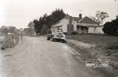 Eltham District Historical Society Inc
Photograph, Sherbourne Road, Para Road and Simms Road at Briar Hill, 3 November 1967, 3 Nov 1967
Viewed from Simms Road in front of Mrs Cameron's house in what is now the northwest bound lanes of Para Road prior to the roundabout intersedction with Sherbourne Road. Simms Road is running to the right in front of the old house. The house belongs to Mrs Cameron whose daughter married a DAVEY after which Davey Street is named. Excavation work is being undertaken for the realignment of the Para Road and Sherbourne Road intersection where the current roundabout is located, approximately where the two cars are parked. Mrs Cameron's house and the other are where Montmorency Secondary College is situated. The school opened in 1969.Roll of 35mm black and white negative film, 6 strips Ilford HP3briar hill, cameron, davey, davey road, graham body works, greensborough, montmorency secondary college, sherbourne road, simms road