Showing 11181 items matching " planning"
-
 Melbourne Tram Museum
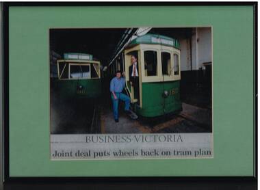
Photograph - Framed Photographs, Business Victoria, "Business Victoria - Joint deal puts wheels back on tram plan", Sep. 1999
Framed photograph - metal frame, cardboard backing, light green card window mat, of Mike Ryan (VicTrack) as Project Manager for the redevelopment of the Hawthorn Tram depot and Matt Faubel of the Urban Land Corporation for The Age newspaper article titled "Business Victoria - Joint deal puts wheels back on tram plan", 13/9/1999. On the rear of the frame is a photocopy of the article. Photographed on tram 180, with 610 alongside and a photograph of the Hawthorn depot. See also Reg item 2726.2 for an associated newspaper cutting and 2726.6trams, tramways, victrack, hawthorn tram depot, reconstruction, tram 180, tram 610 -
 Melbourne Tram Museum
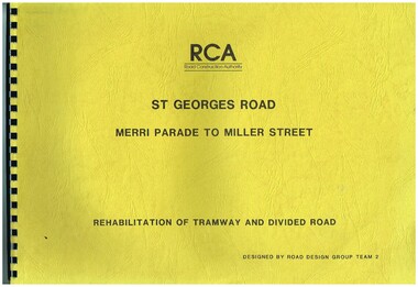
Drawing, Road Construction Authority(RCA), "St Georges Road - Merri Parade to Miller St - Rehabilitation of Tramway and Divided Road", Dec. 1988
Set of two comb bound drawings for the "St Georges Road - Merri Parade to Miller St - Rehabilitation of Tramway and Divided Road", stippled card covers, providing details of plans, drainage, cross sections, track locations for the reconstruction of the roadway. Prepared Dec. 1988, used 1989. 621.2 Second volume titled "Amended Cross Sections" Prepared by the Road Construction Authority - RCA - Road Design Group Team 2. See Reg item 2653 for reports prior to the work being undertaken.trams, tramways, st georges rd, thornbury, northcote, tramways, road works, construction -
 Melbourne Tram Museum
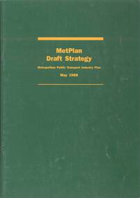
Document - Report, Metropolitan Transit Authority (MTA), "Metplan Draft Strategy - Metropolitan Public Transport Industry Plan - May 1988", May. 1988
Report - 40 pages, green card cover, centre stapled titled "Metplan Draft Strategy - Metropolitan Public Transport Industry Plan - May 1988", looking at Melbourne's transport needs over the next 15 years. Comments were to close on 15/8/1988. Produced by the MTA, signed off by K. P. Shea as Managing Director. Has an index, looks at the Task, heavy, light rail, tram, bus, taxis, ticketing systems, management, and the various regions including funding and budget.trams, tramways, discussion paper, transport, light rail, tramways, railways, road transport, minister for transport, mta, metplan -
 Bendigo Historical Society Inc.
Document - MINING REPORTS - MINING REPORTS BY A RICHARDSON
Handwritten reports dated May 1968 by A. Richardson. On the 4th May visitors from Hobart toured the Central Nell, Victoria and New Chum Hill areas. Also on the 4th, a visit from Mr Geo Lambert who gave him a geological report of the Victoria Hill area. On the 13th May, a visit from Mr K W Smith who showed him slides of derelict W. A. mines. Also plans for the preservation of Mining in Bendigo at Victoria Hill and the preservation of the Central Nell Gwynne poppet legs.document, mining reports, mining reports by a richardson, mr geo lambert, hon j c balfour, mr n wakefield, mr k w smith, le fevre boy's tech high school, mrs f leak, mr perry, gt extended hustlers, central nell gwynne, the pioneer, gunther & party, lansell's fortuna, mt alvernia hospital, a richardson, devonshire mines, bendigo & district tourist association, mrs checcucci, mr jackman, mr greenway, r a c v, cl gerry, eureka extended, bendigo branch historical society -
 Bendigo Historical Society Inc.
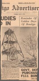
Newspaper - CENTRAL NELL GWYNNE MINE - NEWSPAPER ARTICLE ON CENTRAL NELL GWYNNE MINE
Newspaper article from the Bendigo Advertiser, dated Thursday, May 4, 1967 on the Central Nell Gwynne Mine. It has a picture of the poppet legs of the Central Nell Gwynne Mine with an old gold digger's dish in the foreground and a bush on the right. The article mentions tourists ask to see a gold mine, but none are working. The Bendigo branch of the National Trust has asked the council (who are the trustees of this once famous gold mine) whether it has any plans for the development of the site of this mine and the city engineer to make a report.newspaper, bendigo advertiser, central nell gwynne mine, central nell gwynne mine, newspaper article on central nell gwynne mine, bendigo advertiser, bendigo city council, bendigo branch of the national trust -
 Clunes Museum
Document - ARCHITECTURAL DRAWINGS, CLUNES WATER SUPPLY
CLUNES WATER SUPPLY .1 DRAWING No 21 (CHANGED TO 11). LOWER WEIR. DETAILS OF MASONRY - DESIGN B .2 DRAWING No 5 CONTRACT No 2. LONGITUDINAL SECTION OF CENTRE LINE OF LOWER AQUEDUCT FROM WEIR A TO SERVICE RESERVOIR .3 DESIGNS FOR WEIRS - CROSS SECTION OF THE BED OF THE CREEK SHOWING WEIR STRUCTURE. .4 DRAWING No 11. LONGITUDINAL SECTION - PROPOSED LINE OF PIPES No 1 RESERVOIR. .5 DRAWING No 17 SECTIONS. HANDWRITTEN. .6 DRAWING No 5. PLAN OF LINE OF PIPES No 1 RESERVOIR..2 HANDWRITTEN NOTES ON REAR IN PENCILclunes, water supply, drawings -
Federation University Historical Collection
Drawing - Rubbing, Rubbing on a plaque relating to the Sky High Restaurant
This is thought to be the work of Keith Rash of Ballarat.A number of rubbings from plaques on buildings. .1) Sky High Restaurant .2) Pioneers Tablet (Probably relating to the Pioneers Plot at the Ballaarat Old Cemetery. .3) and .4) Plaque relating to the Pioneers tablet.1) This Skyhigh restaurant was officially opened by The Hon. Vance Dickie M.L.C. Minister for Tourism on the 25th March 1971 This building was planned and constructed for The Ministry of Tourism J. Dale Fisher F.R.A.I.A. Architect W.J. Cody & Quinn Pty Ltd Builders .2) (logo) This tablet was erected by the citizens of Ballarat in honour of the pioneers of this city and district. .3) This MEMORIAL TABLET was unveiled on the 3rd May 1961 by F.W. WRAY, Esq in the company of S.C. HENDERSON, Esq. The only remaining members of the Original Pioneers Memorial Committee.architecture, j. dale, w, j, cody & quinn, skyhigh restaurant, frottage, rubbing, ballarat pioneers, keith rash -
 Kew Historical Society Inc
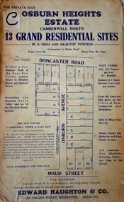
Plan - Subdivision Plan, Osburn Heights Estate, 1938
Edward Haughton & Co, in promoting the Osburn Heights Estate in what is now Balwyn North, attempted to capitalize on the subdivision’s proximity to East Kew. One section of the plan is includes the text: ‘The New Suburb: Camberwell North or East Kew (the names are synonymous)’. The Osburn Heights subdivision was part of a series of subdivisions running between Doncaster Road and Maud Street, including the ‘Pointed Firs Estate’ (MAP.0010). This subdivision included 13 ‘grand residential sites’ for sale in Doncaster Road, Maud Street and Osburn Avenue.subdivision plans - camberwell north, osburn heights estate -
 Victorian Aboriginal Corporation for Languages
Conference proceedings, Barbara Burnaby, Indigenous languages across the community, 2002
Language - Preservation and use. Language - Social function. [Maori: New Zealand Latin]. Language planning. [Language planning in a trans-national speech community]. [The way of the drum - when earth becomes heart] [The need for an ecological cultural community] Community language management. [Methods of madness: The Tuscarora Language Committee] [Daghida: Cold Lake First Nation works towards Dene language revitalization] [The Jicarilla Apache language summer day camp] [Report on the workshop "World of Inukitut"]. Arizona. New Mexico. Oklahoma. Adult education. Women's literacy. [Teaching reading with puppets] [Assessing Lakota language teaching issues on the Cheyenne River Reservation] [Incorporating traditional Nehiyaw/Plains Cree education in the university] [Collecting texts in Crao and Portuguese for teaching] [Early vocabularies and dictionary development: A cautionary note] [The process of spelling standardization of Innu-Aimun (Montagnais)] Pidgin. Creole. [Ojibway hockey CD-ROM in the making] [The use of multimedia and the arts in language revitalization, maintenance and development: The case of the Balsas Nahuas of Guerreo, Mexico] [The languages of Indigenous Peoples in Chukotka and the media] [Meeting of the Inukitut and Yupik family of languages on May 12, 2000]B&w photographs, diagrams,international language forum, community based practice, language research, conference papers, language policy, language and whole community development, literacy development, media, educational advances, canada, united states, new zealand, zimbabwe, mexico, russia, caribbean, inui, yupik -
 Melbourne Tram Museum
Document - Personal Papers, The Age, Keith Kings, Progress Press, Higgins Teale & Co, Herald Sun, house built using former PMTT tramcars, 1976 to 1983
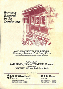
Collection of Personal Papers regarding a house built using former PMTT tramcars. Comprises: 1 - Auction notice - folded A3 light card, "Moonta 18 School Road Ferny Creek" - giving details of the property, agents, floor plan and auction date of 19/11/1983. Agents R. Woodard and D&S Ham (2 copies held) 2 - Newspaper clipping from the Progress Press with a sketch and article - "Home built from trams" 3 -"Fares please for tram treat" - Herald Sun, 24/9/1983. 4 -Auction notice - 21/11/1983 - property passed in. 5 - hand written note, with plan of the trams and location map - not dated 6 - set of six hand written notes recording conversations with various people regarding a house in Ferny Creek with trams, including the Public Trustee 1976 and 1977. 7 - Auction notice for "Charrawalla" - School Road, Ferny Creek dated 7/5/1977 from The Age. Not all items numbered, See also Reg Item 1356, 1833 and 1518 for related items.trams, tramways, mmtb, pmtt, ferny creek, tramcars, melbourne, houses, sale of land -
 Bendigo Military Museum
Photograph - Co-ordinatorgraph Map Grid Production, Army Survey Regiment, Fortuna Bendigo, c1960s to 1970s
This is a set of seven photographs of map grid production using co-ordinatorgraphs at the Army Survey Regiment, Fortuna Bendigo. c1960s to 1970s. The Aristo Co-ordinatorgraph introduced in 1962 was a large heavy steel framed light table with a scribing head that moved in a XY direction using a vernier calibrated measuring scale to 0.001 of an inch. Whilst hand operated it was much quicker and accurate than manual grid and graticule calculation, plotting and scribing. Mapping PNG presented the Regiment with many challenges. WO1 Farrington and CPL John Dean developed computer software for the digitally controlled co-ordinatorgraph, the Calcomp 718 Flatbed Plotter. Much time was saved by automatically plotted cartographic grids and graticules, and automatically draw base compilation sheets complete with aerial triangulated stereo model control. This could be used for a number of maps and was the first step towards map automation. The history of co-ordinatorgraphs is covered in more detail with additional historic photographs, in pages 50 to 51 and page 88 of Valerie Lovejoy’s book 'Mapmakers of Fortuna – A history of the Army Survey Regiment’ ISBN: 0-646-42120-4. SGT Bill Boyd appearing in photo .1P reach the rank of WO1 and for 11 years was the technical warrant officer at the Detachment Army Survey Regiment located at Bonegilla, Victoria. He was awarded the OAM, the Order of Australia Medal for the development of the Flexiflow quality control system. This system comprised a series of job plans and charts linked to a task allocation to resource magnetic planning board. Using critical path analysis and task prioritisation, complex job planning was efficiently scheduled, and re-prioritisations readily made. Reproduction requirements were effectively coordinated by way of weekly courier to the Army Survey Regiment. Supervisors and technicians fully embraced the system as they could understand their role, others around them and the positive production achievements. Bendigo. See page 178 of Valerie Lovejoy’s book for more information on WO1 Boyd’s contribution to RA Svy.This is a set of seven photographs of map grid production using co-ordinatorgraphs at the Army Survey Regiment, Fortuna Bendigo. c1960s to 1970s. The photographs were printed on photographic paper and are part of the Army Survey Regiment’s Collection. The photographs were scanned at 300 dpi. .1) - Photo, black & white, c1960s, L to R: SGT Bill Boyd demonstrating Aristo Co-ordinatorgraph equipment to unidentified technicians (x3) .2) - Photo, black & white, c1960s, Aristo Co-ordinatorgraph equipment. .3) - Photo, black & white, c1960s, unidentified technician operating Aristo Co-ordinatorgraph equipment. .4) - Photo, black & white, c1960s, L to R: PTE Desi Asaris and CPL Kalen Sargent operating Aristo Co-ordinatorgraph equipment. .5) - Photo, black & white, Photo, black & white, c1970s, John Bloor operating Calcomp co-ordinatorgraph equipment. .6) - Photo, black & white, Photo, black & white, c1970s, unidentified technician operating Calcomp co-ordinatorgraph equipment. .7) - Photo, black & white, Photo, black & white, c1970s, L to R: SGT Andy Covington and SGT John Waight operating Calcomp co-ordinatorgraph equipment..7P annotated on back ‘Covington & Waight’.royal australian survey corps, rasvy, army survey regiment, army svy regt, fortuna, asr, carto, air survey -
 Eltham District Historical Society Inc
Document - Property Binder, 801 Main Road, Eltham
1. Plan: Henry Dendy's Eltham Land 1857-1867: showing Diamond Creek, Bridge Street, Maria Street now Main Road, John Street, Pitt Street, St Margaret's Church 1861, and Eltham Community Centre 1987. 2. Photocopy extract from "Henry Dendy and his emigrants" by L A Schumer, re Portions 12 and 13, Parish of Nillumbik. 3. The President and Councillors of the Shire of Eltham request the pleasure of ____ at the Official Opening of the Eltham Community Centre, Cnr Main Road and Pitt Street, Eltham by the Honorable R.J. Hamer E.D., M.P., Premier of Victoria on Saturday, 22nd April, 1978 at 3.30pm 4. Souvenir Program, Opening of Eltham Community Centre 22 April 1975. 5. Invitation to attend Official Opening of Eltham Community Centre by R J Hamer, Premier of Victoria, 22 April 1975. 6. Flier for Eltham Reception and Conference Centre, photographs of interiors during events. 7. Newspaper article: Eltham buries present for the future, Diamond Valley News 19 November 1985 Eltham, photograph of burying time capsule outside Eltham Community Centre, photograph of Bill Baker and Sid Brown outside old blacksmith shop the original site of Eltham town centre. 8. Letter Peter Butler Shire of Eltham to Eltham District Historical Society, 6 July 1987, detailing process for naming of the halls at the Eltham Community Centre.6 July 1987. 9. Plan of Main Road Eltham - it depicts buildings and occupiers from Pitt Street to Luck Street in the first half of the 20th century. This plan was compiled as a joint efforts by members of the Shire of Eltham Historical Society at a general meeting in Eltham during the 1980s. Newspaper article: Swimming pool and community centre receive major revamps, Diamond Valley Leader, 21 October 2015.main road, eltham, eltham community centre, henry dendy, eltham reception and conference centre, bill baker, sidney brown blacksmith, tme capsule, arthur street, babe taylor house, bakery, boarding house, bradley house, bridge street, brown blacksmith, burgoyne's shop, cockcrofts store, commercial bank of australasia, david lyon house, davis, dr cordner, dr hall, dudley street, eltham hotel, eltham obelisk, eltham war memorial, garnet burges, graham, hawker, henry street, john lyon, len perron, luck street, lyons garage, map, mechanics insitute, monteith house, mrs morris shop, our lady help of christian’s primary school, panther place, pitt street, prior street, shillinglaw cottage, shops, stones mixed shop, websters house, wesleyan methodist church, york street -
 Flagstaff Hill Maritime Museum and Village
Document - Navigation Chart, Admiralty Office, Lady Bay and Warrnambool Harbour, 1893
This navigation cart of Lady Bay and Warrnambool Harbour was originally surveyed in 1870 but this version includes the update for magnetic variation in 1893. Since the printing of the chart several annotations have been added. These include an additional stamp dated 15-8-1910, a handwritten comment across the top of the page dated August 1910, and another handwritten comment regarding the ‘Proposed Extension of Dock’ dated 19-2-1925, plus connected drawings, notes and figures. The 1925 proposal on this chart may have been a reaction to the Royal Commission of 1923, when the damaged stonework on the seaward side of the Warrnambool Breakwater, caused by the action of the sea, was the subject of enquiry. A conference between the Public Works, Water Commission and the Harbour Trust concluded that it would less costly to make repairs to prevent further damage rather than replaced the damage portion of the wall. A contract was raised in late 1924 to deposit rubble on the damaged side of the breakwater to minimise the Southern Ocean’s destructive action and work had started by August 1925. The Breakwater construction had begun in 1874 and was completed in 1890. The Victorian Government had commissioned Sir John Coode, a British harbour engineer, to present a plan to complete the Warrnambool Breakwater but his original plan was too expensive. He prepared a revised plan for a shorter structure. The construction proved to be too short to protect adequately from the weather and didn't allow enough depth for larger vessels to come into port. The decreasing trade was further affected by siltation in the bay due to the breakwater, and the completion of the railway line. The situation of the harbour became a real problem by 1910 and required continuous dredging. In 1914 the Breakwater was extended but proved to be a failure because the work began to subside and by 1920 about two thirds of the harbour was silted up. Alterations made in the 1920's increased the silting problem and by the 1940's the harbour was no longer used. More alterations were made in the 1950's and 1960's. This chart is significant for its strong connection to the maritime history of Warrnambool Harbour and Lady Bay and the Warrnambool Breakwater. The Warrnambool Breakwater is registered as a place of significance on the Victorian Heritage Database (VHR H2024). The Warrnambool Breakwater is one of the most important late 19th century maritime engineering projects in Victoria and significant in the development of Victorian coastal shipping. It is also significant for its connection with British harbour engineer, Sir John Coode. The chart is a historical record of structures existing in 1893; the Warrnambool Jetties, Warrnambool Breakwater in Lady Bay, the leading lights (lighthouses), streets, roads, bridges and many buildings. It also shows the lay of the land and seabed. Navigation Chart: Lady Bay and Warrnambool Harbour, Australia - South Coast - Victoria. Surveyed by Nav. Lieut. H.J. Stanley, R.N., 1870. Updated for Magnetic Variation, 1893. The rectangular chart is printed on heavy cream paper. Stamps are shaped rectangular, oval and round. Around the Breakwater and Jetty area are handwritten notes, dotted and joined lines, numbers and signatures, and shading of red and green. The chart shows the surrounds of Warrnambool Harbour, Lady Bay, the Breakwater and Jetty, roads, bridges and the streets in Warrnambool. It has sounding details, and angles of line from the leading lights.Stamp, rectangular, including "AUG 1910" Stamp, double oval " - - - -CHART" Stamp, hand drawn, red circle, with "B" inside Hand written note "22-8-1910 - - - - - of surveying C. Ca - - - request of 15-8-10 [initials] " Notes and lines in red pen, including a grid of sounding numbers: "1300" "1050" "1200" "Possible Extension of Dock" "19-2-25" "Dock Dredged to 20 Ft" Notes and lines in blue pen "Extension of Dock to accommodate vessels drawing 20 Feet" and "Light not visible south of this line" Red dots (4) with yellow highlight at both leading lights, breakwater and jettyflagstaff hill, warrnambool, flagstaff hill maritime museum & village, maritime museum, maritime village, shipwreck coast, map, chart, navigation chart, plan, lady bay, warrnambool harbour, port of warrnambool, breakwater, jetty, pier, dock extension, proposed extension, vhr h2024, 1870, 1893, 1910, 1925, warrnambool town late 1800s, warrnambool streets late 1800s royal commission, 1923, public works, water commission, harbour trust, victorian harbours, sir jon coode -
Glen Eira Historical Society
Letter - St. James Parade, 11, Elsternwick
Five documents all relating to the estate of Lillian Jean Adami of 11 St James Street, Elsternwick A request for a sworn valuation on the auction price for the property and the contents from office of Public Trustee. A carbon copy of sworn valuation of the property and contents by Wv Scott FCIV. Includes an inventory and valuation of furniture and effects on and about the property, working notes on the valuation of the building and a copy of the Certificate title for Lot 16 subdivision 9341 on the western side of St. James Parade, Elsternwick Vol 5268. Folio 496 includes site plan and encumbrances referral.simmons s.p., plans, point nepean road, adami lillian jean, house, elsternwick, scott wv, st. james parade, prahan, estate agents, county of bourke -
 Eltham District Historical Society Inc
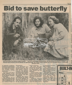
Newsclipping, Bid to save butterfly, Diamond Valley News, 1987, 1987
Local Newspaper article promoting a community meeting for the purposes of developing an action plan to save the Eltham copper Butterfly from extinction after its discovery in its breeding place, the sweet bursaria shrub. Michael Braby, David Cameron and Pauline Toner M.P. are pictured. Early 1987. After the re-discovery of the rare Eltham copper Butterfly in large numbers in Eltham in 1987 Pauline Toner M.P. worked to preserve its habitat. Her work is recognised in the naming of the Pauline Toner Butterfly Reserve on the corner of Pitt Street and Eucalyptus Road in ElthamDigital file only - Digitised by EDHS from a scrapbook on loan from Beryl Bradbury (nee Stokes), daughter of Frank Stokes.beryl bradbury (nee stokes) collection, david cameron, eltham copper butterfly, michael braby, pauline toner -
 Eltham District Historical Society Inc
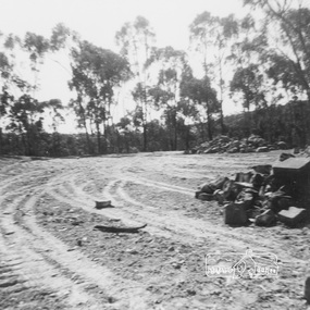
Work on paper (item) - Photograph, 2 Metery Road, Eltham South
Robert and Ada Zull built an Alistair Knox designed house at 2 (lot 8) Metery Road, Eltham, a one acre property for their family of five in the mid 1960s. The cleared block is an expanse of dirt with wheel tracks, with trees and bush in the background and piles of rocks on the right hand side. Susan Bennett, nee Zull's reminiscences are published in EDHS Newsletter, February and April 2020. ".. the block was big.. Building the house was slow going. The plans had to be discussed, then drawn up, finance found, council permits obtained and labourers engaged. " This series of photographs together with the account of personal remiscences provide a unique document of the construction of an Alistair Knox designed home. Knox was a pioneer in the use of mudbricks and recycled materials and is significant to his contribution of this style of architecture in Eltham and the wider Shire of Nillumbik.zull family, clearing, eltham south, 2 metery road, alistair knox -
 Eltham District Historical Society Inc
Folder, Colemans Corner, Eltham
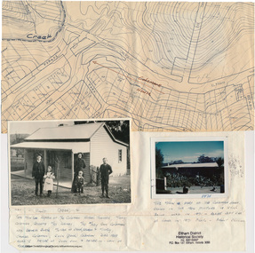
Letter from Nillumbik Council to H.Gilham in response to consultation on Wattletree Road Bridge replacement, 13 August 2007, 1p. VicRoads brochure on Wattletree Road bridge replacement project, August 2007, 1p Photo of "Coleman's house", 1904 with brief family history. (Photo retrieved by Harry Gilham from from a 1972 'time capsule bucket' found at the Eltham Shire Office during its demolition in July-August 1996 (See also SEPP_0745 and 1678A) Photo of "Coleman's house", 1971 Survey plan showing location of Coleman's houseFolder of information and photos relating to the Colemans Corner precinct located on the corner of Main Road and Wattletree Road, Eltham. HG Booklet 9bus services, wattletree road bridge, coleman family, coleman's corner, harry gilham collection -
 Nhill Aviation Heritage Centre
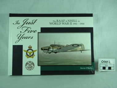
Book, K. O'Reilly, In Just Five Years - 1941 to 1946, Published 2009
Hardback,history of the RAAF & Nhill in World War II 1941 - 1946, written by Kevin O'Reilly. Front coloured white & blue, photo of Avro Anson Mk1 on front, with emblems of RAAF and Shire of Lowan. Reverse in simlilar colours, with cartoons and 8 small photos. Preface by Chris G Spence AO, Air Vice Marshal (Retd).history world war ii, raaf base nhill, 1941 1946, kevin o reilly, john clarkson, peter isaccson wing commander retd am dfc afc dfm, chris, spence, air vice marshal retd -
 Federation University Historical Collection
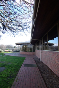
Photograph, Federation University Australia E.J. Tippett Library, 2020, 23/09/2013
The E.J. Tippett Librocate.ary is named after the late E.J. Tippett who was a long time President of the Ballarat School of Mines Council, and library advocate. In February 1985, the first sod for the new SMB Campus building was turned by the Minister for Planning and the Environment, the Hon. Evan Walker, M.P. The overall responsibility for the building rested with the Public Works Department in association with the SMB Campus architect, Ewan Jones & Associates and the builder, S. J. Weir Pty. Ltd. They put together the facility that is both functional and of a style that merges with the surrounding architecture. The new building opened in 1986.Colour photographs showing the exterior of the E.J. Tippett Library at Federation University Australia SMB Campus. e.j. tippett library, tippett library, smb library, tippett, e.j. tippett, ewan jones and associates -
 Greensborough Historical Society
Map, Melbourne and Metropolitan Board of Works. Survey Division, MMBW, Yarra 2500 / 12.22. Watsonia North, 1978_03
Melbourne and Metropolitan Board of Works. Yarra 2500 [base map]. 12-22, Parishes of Keelbundora 2856, Municipalities of Whittlesea 239 and Diamond Valley 257. Shows street names, easement sizes, lot numbers, lodged plan numbers, names of prominent features, contour values, creek or river names. Watsonia Railway Station and environs. Prominent streets: Edmund Rice Parade and Macorna Street. Includes Christian Brothers Edmund Rice College and Janefield Special School sites and "proposed future freeway" (now Metropolitan Ring Road).MMBW Map in 1:2500 [scale] series. Cream parchment with green tape reinforcing on edges and punched holes on left edge.mmbw, melbourne and metropolitan board of works, shire of diamond valley, watsonia - maps, bundoora - maps -
 Greensborough Historical Society
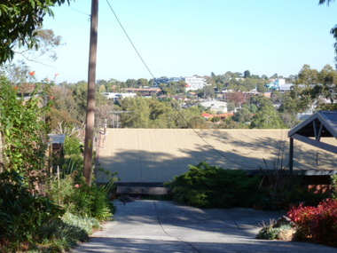
Photograph - Digital image, View of Greensborough from Delfin Crescent, 02/05/2013
This photograph of Greensborough was taken from Delfin Crescent in 2013 to show changes over 40 years, based on Ron Reynold’s sketches in the 1973 publication “Greensborough and Greenhills” published by Cypress Books. Delphin Crescent [previously known as Medhurst Street] was created about 1970 in association with the Delfin Building Company. It was at this time also, that major works on Diamond Creek Road raised the level of the road facilitating the connection of Delfin Crescent with Diamond Creek Road. [Note: 'Medhurst Street was only listed on planning maps pre 1950 when the 'street' had no residents or development.]Digital copy of colour photograph.greensborough and greenhills -
 Eltham District Historical Society Inc
Negative - Photograph, Visit by Premier Hamer to Austin Hospital and presentation of Lifetime Governorship to P.J. Catchlove, c. July 1973
Luncheon reception held at Austin Hospital, Heidelberg to open appeal for the Stage 2 Building Appeal. The July 1973 appeal's target was $500,000, which with government subsidies aimed to pay for a nine-story building alongside stage one - a combined ten-storey teaching, research and medical centre. The new block was planned to provide the Austin Hospital with 218 additional beds, eight extra operating theartres and a comprehensive range of medical, diagnostic, therapeutic and anciliary services. The hospital conducted a door knock appeal in the Heidelberg and Eltham districts on Sunday July 22.Negative black and white film 120 6x6 format 4 stripsIlford HP4 Panchromaticaustin hospital, austin hospital appeal, austin hospital appeals committee, colin j. bock, cr. j.o. white, fundraising, h. foletta, heidelberg, hon. r.j. hamer, other areas, p.j. catchlove, premier of victoria, rupert hamer, sepp, shire of eltham pioneers photograph collection, shire president, victorian premier -
 Melbourne Water
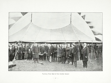
Photograph - Turning Of The First Sod, 1908
The 19th of May marks the anniversary of the turning of the first sod of the outfall sewer. In 1888, a Royal Commission into Melbourne’s public health led to an ambitious plan to construct a sewerage system of underground pipes, sewers and drains to carry sewage from homes and factories to a sewage treatment farm. The commission also supported the establishment of the Melbourne Metropolitan Board of Works (MMBW), the authority that would build the sewerage system and manage Melbourne’s water supply. This photograph is from The Melbourne and Metropolitan Board of Works Water Supply, Sewerage, and etc Photographic Views, 1908This photograph is in excellent condition and provides a detailed insight into Board personnel of the MMBW. It is of historical importance to the history of Melbourne in the turning of the very first sod.Black and white photographphotograph, mmbw, melbourne metropolitan board of works, melbourne water, historic, turniing of the first sod, book, sewerage, water -
Clunes Museum
Certificate
Certificate dated 4 June 1913 dated and signed by W E Entwistle, F J Eberhard and John Henry Lean (Secretary. Recognising Bro. O Wiliams for his contribution to Clunes Lodge as Noble Grand an elected position who sits as Chair for Meetings, and is Official Representative of lodge to outside persons and organizations and see that the lodge program is planned in advance. He was also elected to the position of Vice Grand who exercises power to assist Noble Grand in Presiding Meetings. Assume the duties and responsibilities of the NG in times of absence.Framed (decorative wooden) coloured printed certificate issued to Bro. O Williams of the Clunes Lodge number 4576. Issed by Independent Order of Oddfellows/Manchester Unity Friendly Society.Red Seal "Loyal Clunes Lodge"manchester unity, oddfellows, williams, clunes lodge -
Tatura Irrigation & Wartime Camps Museum
Folder, Persian Group
List of names, hut allocation and leaders of Persian Group relocated from Loveday to Camp 1. Copy of "Decision in Persia" by Philipp W. Fabey. Copies of sketches by Eugen Graf Mensdorff. Letter from Graf von Mensdorff, camp leader to German Red Cross. Plan of Loveday Camp 14. Records of Arnold Abineri, Copy of passport, records & recollections of Stephan Asboth. Theatre Programs. Copies of mail covers. Correspondence re repatriation questionnaire. Magazine for Hockey Group, 1943, including distribution list. Jeppe von Bergo - cast in playBlue two ring folder with printed material in plastic sleeves.documents, reports -
 Robin Boyd Foundation
Document - Script, Robin Boyd, The Flying Dogtor. Episode 25 The Countdown, 1963
Major Minor, the space mouse, was feeling well again now that no-one was poisoning his food and plans were made to send him up in the satellite that afternoon. The countdown began. Major Minor was strapped in and given his camera, notebook and cheese lunch packages for seven orbits. The Flying Dogtor thought his work in Woomera had been completed when he realised they’d given the space mouse the wrong package. The Dogtor and the Secret Service Man looked at each other in horror because that meant that Crafty was onboard the rocket!The Flying Dogtor" series was broadcast on Australian Television Network (later becoming the Seven Network) between February and April 1964 (see item D254 for schedule).Handwritten, foolscap, 2 pagesThe title is crossed out. Many edits.the flying dogtor, robin boyd, crawford productions, manuscript -
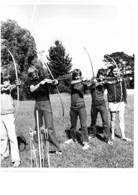 Melbourne Legacy
Photograph - Junior legatee outing, Archery, c1966
Photograph of 4 teenage boys doing archery with an instructor.It appears to be an outing planned for junior legatees or as part of a camp. Melbourne Legacy provided many activities and opportunities for junior legatees to participate in. It came from a Legacy envelope marked P7, 1966. The contents were described in red pen as: 1 Christmas Party / Govt House 2 Toy presentation Dept of Education 3 Residence Christmas party 3 HMAS Cerberus / Operation Float / Operation Firewood (added in blue pen). (these other items will be items 00411 to 00416)A record of the items and events provided to Junior Legatees.Black and white photo of Junior Legatees doing archery.On reverse: stamped "Copyright The Herald and Weekly Times" in blue ink, and "P7 Legacy" in blue pen. Was stored in an envelope marked P7, listing it's contents in red pen and 1966 in pencil.junior legatee outing, camp, archery -
 Bendigo Historical Society Inc.
Document - Bendigo Home and Hospital for the Aged, 1860-1970s
The inaugruration of the newly erected Benevolant Asylum took place on 15th March 1860. The asylum is situated on the west side of Commissioner's Gully, Barnard Street, Bendigo. The building itself is the design of Mr Robert A. Love, Architect, the Contractor is Mr Crawford and the Clerk of Works, Mr Wrigley. - from the Bendigo Advertiser 16th March 1860. In the Advertiser Dec 20 1872: the Memorial Stone was added and the design for the front elecvation was carried out as origionally planned with 12 columns of brick and cement each 36 feet high, the bases of which are granite. Typed History of the hospital, and letters regarding classification status and two A4 sized photos of the front of the building.history, national trust bendigo collection, bendigo, benevolant home bendigo, benevolant asylum bendigo, home and hospital for the aged bendigo, ann caudle centre bendigo -
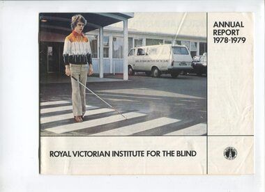 Vision Australia
Administrative record - Text, Royal Victorian Institute for the Blind annual report 1978-1979, 1978-1979
Articles in annual report include: a public educational program speaking to doctors, nurses, teachers, occupational therapists, service clubs and rotated displays through public libraries, RVIB stand won a prize in Community and welfare section at the Royal Melbourne show, difficulties with Mr and Mrs Tye's estates are resolved and plans to build an educational complex at Romsey, acknowledgement of volunteer involvement with Cubs, Guides, Ham Radio and Model Train clubs available to residential children, and the United Kingdom Hotel in Clifton Hill raised over $8000 to become the top hotel fundraiser again.1 volume of text and illustrationsroyal victorian institute for the blind, corporation records -
 Vision Australia
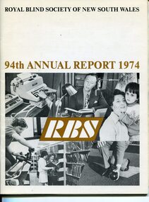
Administrative record - Text, 94th Annual Report Royal Blind Society of N.S.W. (1974), 1974
Articles in the annual report include: death of General Manager Ian Burnet, expenditure exceeding income, need to sell Woolahra (Helen Keller hostel) property, goal of opening 20 new Day centres by the end of 1975, plans to establish Occupational Therapy Training unit, review of aging hostels and restructure workshop, growth of Mitchell Street Theatre, increase of children with more than sight loss at nursery, decision to establish reading competition in memorial to Barbara Rutherford and awarding of Churchill Fellowship to Joan Ledermann for a review of Braille production units overseas.1 volume of text and imagesroyal blind society of new south wales, corporation records