Showing 715 items matching " government printer melbourne"
-
 Tatura Irrigation & Wartime Camps Museum
Book, The Argus Guide to Melbourne, before 1967
Soft cover. illustrated. Line drawing city structures, palm tree. 48 pages. melbourne victoria, victorian government tourist bureau -
 Anglesea and District Historical Society
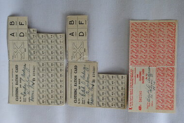
Ration Coupons, H.E. Daw, Government Printer, 1947 to 1948
Ration cards owned by Edith D Anderson, 12 Wilson St, Moonee Ponds. 807/1 1948 Clothing Ration Card. Rg D1 - printed in red - coupons numbering 1 to 56 (B587395) 807/2 1947 Clothing Ration Card. Rg D1 - printed in black - coupons numbering from 33-38, 41-46, 49-54. Also has A - 1947, B1947, D1947, F1947 (B418440) 807/3 1947 Clothing Ration Card. Douglas Anderson, 12 Wilson St., Moonee Ponds. Nos 12 to 56 (B418442)Commonwealth of Australia. Described above - front. Back: If this rationing card is found it must be returned at once to THE DEPUTY DIRECTOR OF RATIONING, Cavendish House, 159 Flinders Lane, Melbourne.ww2, home fronts, ration coupons, rationing -
 Anglesea and District Historical Society
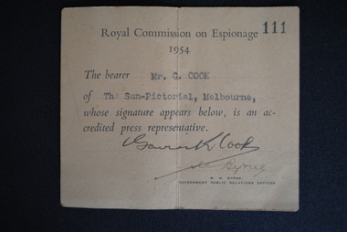
Press Pass, Government Printers, Royal Commission on Espionage, 1954
On 13/4/1954 Prime Minister Menzies told parliament of the detection of Vladimir Petrov and his wife Evdokia to Australia from the Soviet Embassy. Menzies established a Royal Commission on Espionage (RCE) to enquire into and report on Soviet espionage in Australia. This item is a "Press Pass" held by Gavin K Cook and issued by M. Brne (Gov.t Public Relatons Officer).ROYAL COMMISSIUON ON ESPIONAGE / No. 111 / 1954 /The bearer 'Mr G Cook" / of "The Sun-Pictorial, Melbourne, / whose signature appears below, is an ac- / credited press representative. / (Signed: M.W. Byrne / Government Public Relations Officer.royal commission on espionage, 1954, gavin cook, sun-pictorial, melbourne, press pass -
Stawell Historical Society Inc
Book - Law Books, The Victorian Statutes 1929. (5 Vols), 1929
The General Public Acts of Victoria Melbourne: By Authority H.J. Green Government PrinterCardboard & PaperHandwriting marginalia loose front cover -
Koorie Heritage Trust
Document - Report, Board for the Protection of the Aborigines in the Colony of Victoria, Coranderrk Aboriginal Station / remarks of the Board for the Protection of the Aborigines on the report of the Board appointed to enquire into and report upon the condition and management of the Coranderrk Aboriginal Station. 1882, 1882
... Melbourne : John Ferres, Government Printer... of Victoria Melbourne : John Ferres, Government Printer ...4 p. ; 34 cm.coranderrk - report 1882 |, board of enquiry - coranderrk 1882 |, barak, william, wandin, robert -
Koorie Heritage Trust
Pamphlet, Government of Australia, The Aborigines and You, 1963
another phamplet issued by the Government to promote assimilation.p.33; illus; 20 cm. another phamplet issued by the Government to promote assimilation.assimilation - australian aborigines, government policy - assimilation -
Koorie Heritage Trust
Book, Bride, Thomas Francis, Letters from Victorian pioneers : being a series of papers on the early occupation of the colony, the Aborigines, etc., addressed by Victorian pioneers to His Excellency Charles Joseph La Trobe, Esq., Lieutenant-Governor of the colony of Victoria, 1899
... Melbourne : Robt. S. Brain, Government Printer for the..., Government Printer for the Trustees of the Public Library ...The letters record events which will recall to many persons still living old Vctorian memories, and will have a great value for the future historian of Victoria, as narrating the experiences of actual movers in the early scenes of our colonization, while they will also possess interest as incidental contributions to the biographies of the men who half a century ago beagan to encounter the hardships and perils which beset the pioneer in every part of this continent. These papers also contain interesting contributions to our knowldge of the aborigines-their languages, customs , and conflicts with the white men; and although some of the incdents narrated have found their way into print before, they are now for the first time given in their entirety to the public.xiii, 325 p. : figs., map. index; Barabool dialect list; names of the tribe, about 1841-43; ; 22 cThe letters record events which will recall to many persons still living old Vctorian memories, and will have a great value for the future historian of Victoria, as narrating the experiences of actual movers in the early scenes of our colonization, while they will also possess interest as incidental contributions to the biographies of the men who half a century ago beagan to encounter the hardships and perils which beset the pioneer in every part of this continent. These papers also contain interesting contributions to our knowldge of the aborigines-their languages, customs , and conflicts with the white men; and although some of the incdents narrated have found their way into print before, they are now for the first time given in their entirety to the public. frontier and pioneer life -- victoria. | victoria -- history -- 1834-1900 -- sources. -
Koorie Heritage Trust
Book, C. E. Sayers (Original edition edited by Bride, Thomas Francis), Letters from Victorian pioneers : a series of papers on the early occupation of the colony, the Aborigines, etc. addressed by Victorian pioneers to His Excellency Charles Joseph La Trobe, Esq., Lieutenant-Governor of the Colony of Victoria, 1983
... : Heinemann, 1969. Originally published: Melbourne : Government ...Brief notes on the contributors and incidents have been included in this edition although the above-mentioned items have been left out, some marginal notes made by Governor La Trobe have been dealt with in the footnotes. "From the original edition edited for the Trustees of the Public Library by Thomas Francis Bride'. Previously published: Melbourne : Heinemann, 1969. Originally published: Melbourne : Government Printer for the Trustees of the Public Library, Museums and National Gallery of Victoria, 1898.xiv, 455 p., 31 p. of plates : map ; 26 cm.Brief notes on the contributors and incidents have been included in this edition although the above-mentioned items have been left out, some marginal notes made by Governor La Trobe have been dealt with in the footnotes. "From the original edition edited for the Trustees of the Public Library by Thomas Francis Bride'. Previously published: Melbourne : Heinemann, 1969. Originally published: Melbourne : Government Printer for the Trustees of the Public Library, Museums and National Gallery of Victoria, 1898.pioneering, 1836-1854. victoria. correspondence, diaries, etc. | victoria. description & travel, 1836-1854. correspondence, diaries, etc. | frontier and pioneer life -- victoria. | victoria -- history -- 1834-1900 -- sources. | victoria -- description and travel -- 1851-1900. -
Koorie Heritage Trust
Document - Report, Aborigines Welfare Board. New South Wales, Aborigines Welfare Board - Annual reports 1958 - 1967, 1958
Reports to the Government of Victoria on the areas of care under the control of the Aborigines Welfare Board for the period 1958-67.10 parts ; A4.; illus; figs.; tables; Reports to the Government of Victoria on the areas of care under the control of the Aborigines Welfare Board for the period 1958-67.new south wales. aborigines welfare board -- periodicals. | aboriginal australians -- government policy -- new south wales -- periodicals. -
Koorie Heritage Trust
Book, Barrett, Charles et al, Australian Aboriginal Art, 1929
Issued in connection with the Exhibition of Australian Aboriginal Art, National Museum, Melbourne.39 p.; plates; ill.; 21 cm.Issued in connection with the Exhibition of Australian Aboriginal Art, National Museum, Melbourne.national museum of victoria-exhibitions-aboriginal art., artifacts, aboriginal, australia., victorian aboriginal art. -
Whitehorse Historical Society Inc.
Map, Parish of Nunawading, 1970
[Parish of] Nunawading, County of Bourke. Government Printer Showing original land owners.parish of nunawading, maps, land settlement -
 Rutherglen Historical Society
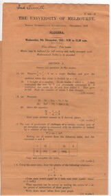
Examination Papers, Algebra. Wednesday, 9th December 1942 : 9.30 to 11.30 a.m, 1942 (Exact)
Donated by the late Terrill, Fred. School Intermediate Examination - December 1942.Examination paper, print in black on long, dark yellow, narrow paper. Scanned in two sections."U 608-U | The University of Melbourne | School Intermediate Examination. December 1942 | Algebra | Wednesday, 9th December, 1942 : 9.30 to 11.30 a.m." Handwritten at top of paper: "Fred Terrill"school examinations, school intermediate examinations, university of melbourne, algebra -
 Rutherglen Historical Society
Examination Papers, Arithmetic. Monday, 14th December, 1942: 9.30 a.m. to 11.30 a.m, 1942 (Exact)
Donated by the late Fred Terrill. School Intermediate Examination - December 1942.Examination paper, printed in black on long, dark yellow, narrow paper. Scanned in two parts"U 650-U | The University of Melbourne | School Intermediate Examination - December 1942. | Arithmetic | Monday 14th December, 1942 : 9.30 a.m. to 11.30 a.m." Handwritten at top of page: "Fred Terrill"school examinations, school intermediate examinations, arithmetic -
 Hume City Civic Collection
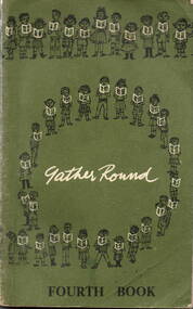
Book - School Reader, Education Department of Victoria, Gather Round/Fourth Book, 1965
A school reader for Grade 4 children.A bound school reader with a soft dark green cloth cover with lettering and diagrams in black and white. Both front and back covers are decorated with lines and circles of children holding readers. Inside there are 248 pages containing stories, poems and illustrations. fictionA school reader for Grade 4 children.school readers, gather round, grade 4, education department of victoria, a.c. brooks, government printer -
Ballarat Tramway Museum
Map, Ministry of Transport, "Melbourne - Your Guide - Public Transport, No. 11, 1980", 1980
Pocket size - folded - public transport map of Melbourne, printed in colour on heavy paper, showing public transport services in greater Melbourne and on rear, route numbers and line maps of tram routes and train lines or services. Includes private bus routes. Printed 1980 by Government Printer. Issue No. 11. Image added 20-12-2016.On front cover, in biro, a telephone number "617 0900"trams, tramways, melbourne, map, routes -
 Ballarat Tramway Museum
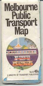
Map, Ministry of Transport, "Melbourne Public Transport Map" - "No. 12", 1982
... Printer. Issue No. 12. "Melbourne Public Transport Map" - "No. 12 ...Pocket size - folded - public transport map of Melbourne, printed in colour on paper, showing public transport services in greater Melbourne, including ticketing information, travelcards and an index of localities. The Central zone area shown in detail. On the rear, route numbers and line maps of tram routes and train lines or services and fare zones. The first map with the new three zone system of fares. Includes private bus routes. Printed 1982 by Government Printer. Issue No. 12.On inside, a circle route around Flinders, Queen, Little Collins and Swanston St in blue felt pen and arrow in blue ink. On the rear, a sketch map showing the location Charles St, Mantell St and William Road, and a circle around Upfield station.trams, tramways, melbourne, map, routes -
 Otway Districts Historical Society
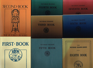
Book, Government Printer, The Victorian Readers, 1986
These eight books that make up The Victorian Readers, one for each of the grades that then comprised the primary school, were first published by the Victorian Education Department between 1928 and 1930. Second editions of all but the First Book, with a few changes in content, appeared some ten years later. One-quarter of the content was required to be Australian with the remainder from Britain, the United States and Europe. Beginning in the 1950s new Departmental publications gradually replaced the old books with the exception of the Fifth and Sixth books which survived until the late 1960s, when commercially-produced reading material finally took over in schools. The Victorian Readers: Books 1 to 8. Facsimile reprint. Ministry of Education (Schools Division); Melbourne (Vic); 1986. Various p.; illus; maps. Soft cover. ISBN 0 7306 0859 Xvictoria; education department; readers; primary education; -
 Otway Districts Historical Society
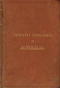
Book, Government Printer, Potato diseases in Australia, 1911
Potatoes are known for their great liability to disease, suffering more from the ravages of fungi than any other crop, and this is largely owing to the fact that they are propagated from tubers which are just swollen portions of underground branches of the stem. Portions of the parent plant in the form of tubers or cuttings are planted year after year, so that any inherent weakness in the original is transmitted to the offspring, and therefore, without a process of selection, deterioration is sure to occur sooner or later. When the tubers are raised from seed and a good selection made from them, they are less liable to disease at least for a number of years. Handbook of fungus diseases of the potato in Australia and their treatment. D. McAlpine. 1st ed. Department of Agriculture, Victoria; Melbourne (Vic); 1911. x, 314 p.; illus., map. Hard cover.potatoes; disease; fungus; agriculture; -
 Bendigo Historical Society Inc.
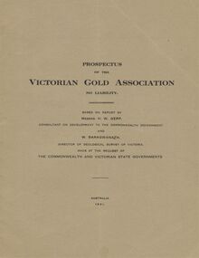
Document - MCCOLL, RANKIN AND STANISTREET COLLECTION: VICTORIAN GOLD ASSOCIATION, 1931
Prospectus of the Victorian Gold Association N.L. Based on a report by Messrs H. W. Gepp Consultant on Development to the Commonwealth Government and W. Baragwanath, Director of the Geological Survey of Victoria. Dated 1931 This company was formed to investigate the Deborah Mine, The Central Nell Gwynne Mine and the Monument Hill Mine. 12 pages including maps and Transverse Sections of the MinesThe Commonwealth and Victorian State Governments. E. Whitehead & Co., Pty., Ltd Printers 21 Equitale Place, Melbourne, C1.gold, mining, prospectus, bendigo, gold mines, victorian gold associatian, deborah mine, central nell gwynne mine, monument hill mine. -
 Bendigo Historical Society Inc.
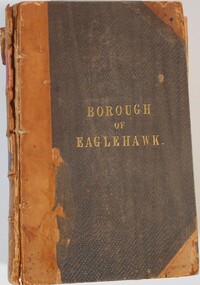
Document - Borough of Eaglehawk, 1856
The Borough of Eaglehawk was a local government area which covered the northwestern suburbs of the regional city of Bendigo, Victoria, Australia. The borough covered an area of 14.54 square kilometers, and existed from 1862 until 1994.Borough of Eaglehawk Acts and Ordinances in force in Victoria edited by Travers Adamson, Esq,. Volume 2, Publish by authority. Melbourne Printed by John Ferres, Government Printers, 1856history, bendigo, mining, borough of eaglehawk, acts and ordinances -
 Bendigo Historical Society Inc.
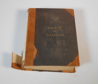
Administrative record - Acts of Parliament Victorian Statutes Vol 1 A-E - Borough of Eaglehawk
... . Printed in Melbourne by john Ferres, government printer, 1866... 1022 pages. Printed in Melbourne by john Ferres, government ...Black hardcover book. On the front in gold letters ''Borough of Eaglehawk. On the spine Victorian Statutes, Vol 1 A-E. Contents: Chronological table, historical table of legislation for or in Victoria, table of acts in Vol. 1. The book has 1022 pages. Printed in Melbourne by john Ferres, government printer, 1866Inside front cover sticker: J.K. Robshaw, stationer and printer, Pall Mall, Sandhurstvictorian legislation, acts of parliament, borough of eaglehawk, 1866 -
Bendigo Historical Society Inc.
Map - WANURP: COUNTY OF BENDIGO, 1/12/33
Map. Wanurp, County of Bendigo, Terrick Terrick East, Mitiamo, Dingee, Milloo, Pannoobamawm. L422+. Photo-Lithographed at the Department of Lands and Survey, Melbourne, Price 2/-. 1/12/33 ( number 411 in Map Cupboard 1 )H.J. Green, Government Printerbendigo, hospital -
 Bendigo Historical Society Inc.
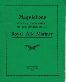
Book - LODGE COLLECTION: BOOK. REGUALTIONS FOR THE GOVERNMENT OF THE DEGREE OF ROYAL ARK MARINER
Lodge book. Regulations for the government of the degree of Royal Ark mariner.G.A. Sharman, Printer, 13 Wrights Lane Melbourneclubs, social, regulations royal ark mariner -
Bendigo Historical Society Inc.
Booklet - Statistics and Civil Establishment of the Colony of Victoria for 1856
Victoria became its own colony in 1851, after being the Port Phillip district of NSW from 1803. These books that were produced regularly to provide statistical information of the Civil, Judicial, Police, Penal, Medical, Ecclesiastical and educational establishments. The civil list includes public servants, listed alphabetically, their role, place of situation and reference to a later page that describes the actual role.113-page blue soft cover booklet. Civil Establishment of the Colony of Victoria for 1856 (Reprint) in the front section. Statistics of the Colony of Victoria for 1856 in the back section. Compiled from Official Records in the Registrar General's Office. First published in 1858, Reprinted in 1975 by C.H.Rixon, Government Printer for the Public Records Office, Melbournestatistics, port phillip district -
 Bendigo Historical Society Inc.
Map - Marong County of Bendigo
Map of Marong. Drawn and reproduced at the Dept. of Lands and Survey, Melbourne. By authority: W.M. Houston Government Printer. June 1953.On the back in blue pen: certified plan parish Marong, signed minister and seal affixed for land S sec.72 evidence act. I certify that this a true plan parish Marong (signature illegible) minister for lands.map, marong -
Moorabbin Air Museum
Book - War Service Record 1939-1945, A. C. Brooks, Government Printer, War Service Record 1939-1945 Education Department, Victoria, 1959
The book is a complete record of all the enlisted individuals in Victoria between 1939 and 1945 who occupied a teaching position prior to service.Dark Blue book with the British coat of arms above the title. All lettering and coat of arms is gold.non-fictionThe book is a complete record of all the enlisted individuals in Victoria between 1939 and 1945 who occupied a teaching position prior to service.teachers, victoria, second world war, education department, service record -
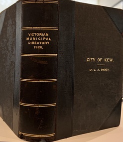 Kew Historical Society Inc
Journal, Arnall & Jackson: Printers & Stationers, Victorian Municipal Directory and Gazetteer : Also Commonwealth Guide and the Water Supply Record for 1928
The Victorian Municipal Directory provided annual details, and later bi-annual details, of all councils. Published by Arnall & Jackson (Printers and Stationers), copies were published in 'cloth' for sixteen shillings and 'half roan' for eighteen shillings. This copy was owned by Cr C.S.Parry. Elected to the Kew City Council as a representative of North Ward, Cr Parry was elevated to the position of Mayor in 1931. It, together with five other editions, was presented to the Kew Historical Society in 1987 by his grandson.Bound copy of the Victorian Municipal Directory and Gazetteer: Also Commonwealth Guide and the Water Supply Record for 1928. The volume contains 846 pages and includes sections on: - Comparative table – Municipal Returns for Twenty-one Years. - Index to Townships, Parishes and Railway Stations. - Changes and appointments. - Commonwealth of Australia (Constitution, Parliament, Departments and Officers). - State of Victoria (Parliament, Departments and Officers / Boards, Institutions, Trusts and Loans). - Municipalities in Victoria (Cities and Towns, Boroughs, Shires). - Water Supply (State Rivers and Water Supply Commission).non-fictionThe Victorian Municipal Directory provided annual details, and later bi-annual details, of all councils. Published by Arnall & Jackson (Printers and Stationers), copies were published in 'cloth' for sixteen shillings and 'half roan' for eighteen shillings. This copy was owned by Cr C.S.Parry. Elected to the Kew City Council as a representative of North Ward, Cr Parry was elevated to the position of Mayor in 1931. It, together with five other editions, was presented to the Kew Historical Society in 1987 by his grandson. victoria -- registers -- periodicals., victoria -- directories., water-supply -- victoria -- directories., municipal government -- victoria -- periodicals., cities and towns -- victoria -- directories. -
 Kew Historical Society Inc
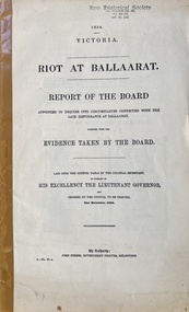
Document, Riot at Ballaarat : report of the Board of Enquiry appointed to enquire into circumstances connected with the late disturbance at Ballaarat ; together with The evidence taken by the Board, 1854
Parliamentary paper (Victoria. Parliament) ; 1854, A. no. 27. "Laid upon the Council table by the Colonial Secretary...and ordered to be printed 21st November, 1854." At head of title: 1854 Victoria. Chairman: Sturt, E.P.S. Cover title. No. 1 of 15 entitled : [Eureka Stockade : a series of 15 reports on the riot at Ballaarat.Melbourne : John Ferres, Govt. Printer, 1854 xv, 22 p. ; 35 cm.non-fictionParliamentary paper (Victoria. Parliament) ; 1854, A. no. 27. "Laid upon the Council table by the Colonial Secretary...and ordered to be printed 21st November, 1854." At head of title: 1854 Victoria. Chairman: Sturt, E.P.S. Cover title. No. 1 of 15 entitled : [Eureka Stockade : a series of 15 reports on the riot at Ballaarat. eureka stockade, ballarat, vic., 1854 -- history -- sources, gold mines and mining -- victoria -- ballarat -- history -- sources, ballarat (vic.) -- history -- sources, victoria -- history -- 1851-1891 -- sources -
RMIT GSBL Justice Smith Collection
Report, Victoria. Parliament. Law Reform Committee, Regulatory efficiency legislation : report, 1997
No. 61 Sessio 1996-97ISBN: 0731108639administrative procedure -- victoria, trade regulation -- victoria, law reform -- victoria -
RMIT GSBL Justice Smith Collection
Book, Victoria, Acts index : 1985, 1985
victoria. laws: etc -- indexes, law -- victoria -- indexes, legislation -- victoria -- indexes