Showing 905 items
matching the rocks
-
 Warrnambool and District Historical Society Inc.
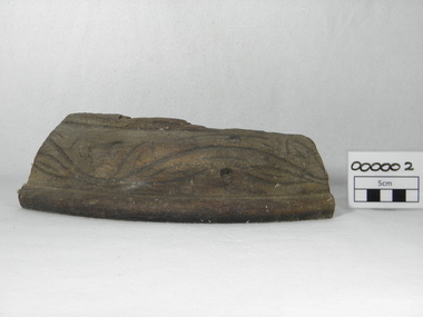
Souvenir - Shipwreck item, Falls of Halladale, 1886
The Falls of Halladale was a four-masted iron-hulled barque built for the long-distance bulk carrier trade. In dense fog on the night of 14 November 1908 she was sailed onto rocks off Peterborough due to a navigational error. The 29 crew abandoned ship safely and reached shore by boat. The ship was left foundering with sails unfurled. For weeks afterwards large crowds gathered to view the ship as she gradually broke up and sank in the shallow water. Shortly after the accident the ship's master, Captain Thomson, faced a Court of Marine Enquiry in Melbourne. He was found guilty of a gross act of misconduct, having carelessly navigated the ship, neglected to take proper soundings and failing to place the ship on a port tack before it became too late to avoid shipwreck. Thomson's punishment included a small fine and six months suspension of his Master's Certificate of Competency. The hull lies on its starboard side about 300 metres off-shore in 3-15 metres of water. The original cargo included 56,763 roofing slates and coils of barbed wire. 22,000 slates were salvaged in the 1980s and used as roofing at Flagstaff Hill Maritime Village, Warrnambool.This item has historical significance as it came from one of the known shipwrecks along the South West coast of Victoria. There are a number of photographs of the wreck as it founded on the rock and hence is an image with which many people are familiar. Curved piece of timber with flat base from the wreck of the ship Falls of Halladale. Inside is recessed with slight ledge near back. A chunk of timber is missing on the top. The face has swirled carvings with leaf and seed design and base curved to the edge.Hand painted in red paint on inside bottom edge 'PETERBOROUGH'. Hand painted in white paint on bottom 'FALLS OF HALLADALE/WRECKED/PETERBOROUGH/VIC/NOV. 1908'melbourne, shipwrecks, flagstaff hill maritime village, warrnambool, falls of halladale, barques, peterborough victoria, roofing slates, captain thomson, thomson, court of marine enquiry -
 Ballarat Heritage Services
Photograph - Colour, Dorothy Wickham, St Just, Cronwall, World Heritage Site
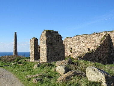
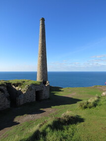
A stone’s throw from Land’s End, this is the most westerly Area of the Site. St Just is characterised by big skies, jagged rocks, stark moorland, and iconic clifftop engine houses perched above the Atlantic in some incredible locations. No wonder this dramatic setting has inspired generations of artists, writers and photographers. World-famous for their mineralogy, the mining sites here are extremely well preserved – as is the sense of community amongst the people whose lives they once dominated. This Area’s unique geography and mineralogy meant that undersea mining was more concentrated here than anywhere else in the world in the 18th and 19th centuries. The oldest surviving Cornish beam engine (constructed in 1840) remains in its original engine house at Levant, restored and still working under steam. Geevor, one of the last mines to close in Cornwall (1990), was saved from demolition and is now the largest metalliferous mine site open to the public in the UK. The historic mining town of St Just is home to characteristic rows of granite mine workers’ cottages, public squares, shops, cafés, art galleries and, just off Bank Square, a medieval grassed amphitheatre – the Plen an Gwary or ‘playing place’.st just, world heritage, ellis, penrose, cornwall, mining, mines -
 Ballarat Heritage Services
Photograph - Colour, Dorothy Wickham, St Just, Cornwall, World Heritage Site
A stone’s throw from Land’s End, this is the most westerly Area of the Site. St Just is characterised by big skies, jagged rocks, stark moorland, and iconic clifftop engine houses perched above the Atlantic in some incredible locations. No wonder this dramatic setting has inspired generations of artists, writers and photographers. World-famous for their mineralogy, the mining sites here are extremely well preserved – as is the sense of community amongst the people whose lives they once dominated. This Area’s unique geography and mineralogy meant that undersea mining was more concentrated here than anywhere else in the world in the 18th and 19th centuries. The oldest surviving Cornish beam engine (constructed in 1840) remains in its original engine house at Levant, restored and still working under steam. Geevor, one of the last mines to close in Cornwall (1990), was saved from demolition and is now the largest metalliferous mine site open to the public in the UK. The historic mining town of St Just is home to characteristic rows of granite mine workers’ cottages, public squares, shops, cafés, art galleries and, just off Bank Square, a medieval grassed amphitheatre – the Plen an Gwary or ‘playing place’.st just, world heritage,, ellis,, penrose, cornwall, mining, mines -
 Ballarat Heritage Services
Photograph - Colour, Dorothy Wickham, St Just, Cornwall, World Heritage Site
A stone’s throw from Land’s End, this is the most westerly Area of the Site. St Just is characterised by big skies, jagged rocks, stark moorland, and iconic clifftop engine houses perched above the Atlantic in some incredible locations. No wonder this dramatic setting has inspired generations of artists, writers and photographers. World-famous for their mineralogy, the mining sites here are extremely well preserved – as is the sense of community amongst the people whose lives they once dominated. This Area’s unique geography and mineralogy meant that undersea mining was more concentrated here than anywhere else in the world in the 18th and 19th centuries. The oldest surviving Cornish beam engine (constructed in 1840) remains in its original engine house at Levant, restored and still working under steam. Geevor, one of the last mines to close in Cornwall (1990), was saved from demolition and is now the largest metalliferous mine site open to the public in the UK. The historic mining town of St Just is home to characteristic rows of granite mine workers’ cottages, public squares, shops, cafés, art galleries and, just off Bank Square, a medieval grassed amphitheatre – the Plen an Gwary or ‘playing place’.st just, world heritage, ellis, penrose, cornwall, mining, mines -
 Ballarat Heritage Services
Photograph - Colour, Dorothy Wickham, St Just, Cronwall, World Heritage Site
A stone’s throw from Land’s End, this is the most westerly Area of the Site. St Just is characterised by big skies, jagged rocks, stark moorland, and iconic clifftop engine houses perched above the Atlantic in some incredible locations. No wonder this dramatic setting has inspired generations of artists, writers and photographers. World-famous for their mineralogy, the mining sites here are extremely well preserved – as is the sense of community amongst the people whose lives they once dominated. This Area’s unique geography and mineralogy meant that undersea mining was more concentrated here than anywhere else in the world in the 18th and 19th centuries. The oldest surviving Cornish beam engine (constructed in 1840) remains in its original engine house at Levant, restored and still working under steam. Geevor, one of the last mines to close in Cornwall (1990), was saved from demolition and is now the largest metalliferous mine site open to the public in the UK. The historic mining town of St Just is home to characteristic rows of granite mine workers’ cottages, public squares, shops, cafés, art galleries and, just off Bank Square, a medieval grassed amphitheatre – the Plen an Gwary or ‘playing place’.st just, world heritage, ellis, penrose, cornwall, mining, mines -
 Ballarat Heritage Services
Photograph - Colour, Dorothy Wickham, St Just, Cornwall, World Heritage Site
A stone’s throw from Land’s End, this is the most westerly Area of the Site. St Just is characterised by big skies, jagged rocks, stark moorland, and iconic clifftop engine houses perched above the Atlantic in some incredible locations. No wonder this dramatic setting has inspired generations of artists, writers and photographers. World-famous for their mineralogy, the mining sites here are extremely well preserved – as is the sense of community amongst the people whose lives they once dominated. This Area’s unique geography and mineralogy meant that undersea mining was more concentrated here than anywhere else in the world in the 18th and 19th centuries. The oldest surviving Cornish beam engine (constructed in 1840) remains in its original engine house at Levant, restored and still working under steam. Geevor, one of the last mines to close in Cornwall (1990), was saved from demolition and is now the largest metalliferous mine site open to the public in the UK. The historic mining town of St Just is home to characteristic rows of granite mine workers’ cottages, public squares, shops, cafés, art galleries and, just off Bank Square, a medieval grassed amphitheatre – the Plen an Gwary or ‘playing place’.st just, world heritage, ellis, penrose, cornwall, mining, mines -
 Ballarat Heritage Services
Photograph - Colour, Dorothy Wickham, St Just, Cornwall, World Heritage Site
A stone’s throw from Land’s End, this is the most westerly Area of the Site. St Just is characterised by big skies, jagged rocks, stark moorland, and iconic clifftop engine houses perched above the Atlantic in some incredible locations. No wonder this dramatic setting has inspired generations of artists, writers and photographers. World-famous for their mineralogy, the mining sites here are extremely well preserved – as is the sense of community amongst the people whose lives they once dominated. This Area’s unique geography and mineralogy meant that undersea mining was more concentrated here than anywhere else in the world in the 18th and 19th centuries. The oldest surviving Cornish beam engine (constructed in 1840) remains in its original engine house at Levant, restored and still working under steam. Geevor, one of the last mines to close in Cornwall (1990), was saved from demolition and is now the largest metalliferous mine site open to the public in the UK. The historic mining town of St Just is home to characteristic rows of granite mine workers’ cottages, public squares, shops, cafés, art galleries and, just off Bank Square, a medieval grassed amphitheatre – the Plen an Gwary or ‘playing place’.st just, world heritage, ellis, penrose, cornwall, mining, mines -
 Phillip Island and District Historical Society Inc.
Souvenir Photographs, Valentine Publishing Co. Pty. Ltd, 1940's
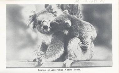
Souvenir Photographic Strip photo envelope donated by Anne LucasBlack & White photographs in a Souvenir Folder. Photos of wildlife and coastal scenes at Phillip Island.On Cover: "Cowes, Phillip Island. Photographic Souvenir" 230-01. "Australian Native Bears (Koalas)." 230-02. "Bathing scene at Cowes." 230-03. "The Pier, showing Isle of Wight Hotel." 230-04. "The Beach at Cowes." 230-05. "Seals on Seal Rock." 230-06. "The Beach, Cowes." 230-07. "War Memorial and Pier". 230-08. "The Pier. Cowes (Phillip Island)" 230-09. "Rocks at Cape Woolamai. Cowes (Phillip Island)." 230-10. "The Nobbies." 230-11. "Sea Birds at Phillip Island." 230-12. "Rocky Headland, Cape Woolamai." 230-13. "Australian Native Bears (Koalas)." 230-14. "Forrest Caves."wildlife - koalas, wildlife - sea birds, coastline cape woolamai, the nobbies phillip island, seals on seal rocks phillip island, wildlife - seals, cowes pier phillip island, cowes jetty, cowes beach phillip island, forrest caves, phillip island, seal rocks phillip island, cowes war memorial, war memorial cowes phillip island, cenotaph cowes phillip island, anne lucas -
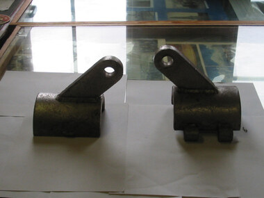
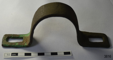 Flagstaff Hill Maritime Museum and Village
Functional object - Bracket
This metal bracket is part of the wooden barque, the Grange, built in 1840. The bracket was recovered from the shipwreck of the Grange in around 1968, 110 years after the Grange was wrecked (see below for further details on the Grange). It is part of the John Chance Collection. THE GRANGE, 1840-1858- The wooden barque ’Grange’ was a three-masted ship built in Scotland in 1840 for international and coastal trade. On March 22, 1858, the Grange set sail from Melbourne under Captain A. Alexander, carrying a cargo of ballast. The barque had left the Heads of Phillip Bay and was heading west along the Victorian coast towards Cape Otway. The ship struck Little Haley’s Reef at Apollo Bay due to a navigational error and was stuck on the rocks. The crew left the ship carrying whatever they could onto the beach. Eventually, the remains of the hull, sails and fittings were salvaged before the wreck of the Grange broke up about a month later. About 110 years later, in 1968, the wreck of the Grange was found by divers from the Underwater Explorers Club of Victoria. They were amazed to find a unique, six to nine pound carronade (type of small cannon) and a cannonball on the site. There have been no other similar carronades recorded. In that same year the anchor of the Grange was recovered by diver John Chance and Mal Brown. The bracket is significant historically as an example of hardware used when building wooden ships in the early to mid-19th century. The bracket is historically significant as an example of the work and trade of blacksmith. The bracket also has significant as it was recovered by John Chance, a diver from the wreck of the Grange in the 1968. Items that come from several wrecks along Victoria's coast have since been donated to the Flagstaff Hill Maritime Village’s museum collection by his family, illustrating this item’s level of historical value. The bracket is historically significant for its association with the 1840s wooden barque, the Grange. The Grange is an historical example of a Scottish built vessel used for international and coastal trader of both cargo and passengers in the mid-19th century. The Grange is an example of an early ship, designed with a wooden hull. It is significant as a ship still available to divers along the south coast of Victoria, for research and education purposes. The Grange is an example of a mid-19th century vessel that carried a weapon of defence onboard.Bracket, brass, U shaped with rectangular flat ends. Both ends have a formed rectangular hole in them; the hole has rounded corners. The metal has corroded in places and has green concretion.flagstaff hill, warrnambool, flagstaff hill maritime museum, maritime museum, shipwreck coast, flagstaff hill maritime village, great ocean road, west coast trader, apollo bay, mid-19th century shipwreck, the grange, scottish barque, little henty reef, captain a alexander, underwater explorers club of victoria, 1840s carronade, vhr 5297, coastal trader, wooden shipwreck, john chance, wooden ship, ship fitting, bracket -
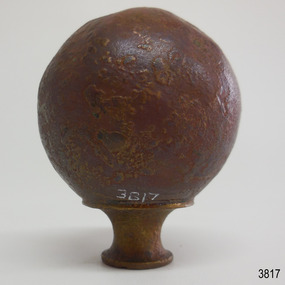 Flagstaff Hill Maritime Museum and Village
Decorative object - Sphere
This metal sphere is part of the wooden barque, the Grange, built in 1840. The sphere was recovered from the shipwreck of the Grange in around 1968, 110 years after the Grange was wrecked (see below for further details on the Grange). It is part of the John Chance Collection. THE GRANGE, 1840-1858- The wooden barque ’Grange’ was a three-masted ship built in Scotland in 1840 for international and coastal trade. On March 22, 1858, the Grange set sail from Melbourne under Captain A. Alexander, carrying a cargo of ballast. The barque had left the Heads of Phillip Bay and was heading west along the Victorian coast towards Cape Otway. The ship struck Little Haley’s Reef at Apollo Bay due to a navigational error and was stuck on the rocks. The crew left the ship carrying whatever they could onto the beach. Eventually, the remains of the hull, sails and fittings were salvaged before the wreck of the Grange broke up about a month later. About 110 years later, in 1968, the wreck of the Grange was found by divers from the Underwater Explorers Club of Victoria. They were amazed to find a unique, six to nine pound carronade (type of small cannon) and a cannonball on the site. There have been no other similar carronades recorded. In that same year the anchor of the Grange was recovered by diver John Chance and Mal Brown. The sphere is significant historically as an example of hardware used when building wooden ships in the early to mid-19th century. The sphere is historically significant as an example of the work and trade of blacksmith. The sphere also has significant as it was recovered by John Chance, a diver from the wreck of the Grange in the 1968. Items that come from several wrecks along Victoria's coast have since been donated to the Flagstaff Hill Maritime Village’s museum collection by his family, illustrating this item’s level of historical value. The sphere is historically significant for its association with the 1840s wooden barque, the Grange. The Grange is an historical example of a Scottish built vessel used for international and coastal trader of both cargo and passengers in the mid-19th century. The Grange is an example of an early ship, designed with a wooden hull. It is significant as a ship still available to divers along the south coast of Victoria, for research and education purposes. The Grange is an example of a mid-19th century vessel that carried a weapon of defence onboard. Sphere; thin hollow copper, various shades of brown, dimpled or hammered surface with a sheen, no joins. Base has a small hole and is fitted with a hollow, cylindrical brass collar. The collar had a rim on top, inward curving sides and a narrower rim on the bottom. The sphere looks similar to a bed post knob.flagstaff hill, warrnambool, flagstaff hill maritime museum, maritime museum, shipwreck coast, flagstaff hill maritime village, great ocean road, west coast trader, apollo bay, mid-19th century shipwreck, the grange, scottish barque, little henty reef, captain a alexander, underwater explorers club of victoria, 1840s carronade, vhr 5297, coastal trader, wooden shipwreck, john chance, wooden ship, ship fitting, sphere, knob, bed knob, post decoration -
 Phillip Island and District Historical Society Inc.
Photographs, Kodak, c 1948
A collection of photographs donated by Rhonda McInnes (nee Closs) from her father, Don Closs 's collection. Taken whilst her parents were courting and had a trip to Phillip Island.327-01 - Black & White photograph of Westernport with Cowes Ferry and other ships in the background. 327-02 - Black & White photograph of Cowes Pier looking towards Cowes. 327-03 - Black & White photograph of the Hollydene Guest House with people standing at the front gate. 327-04 - Black & White photograph of the Cowes Vehicular Ferry arriving/departing from the Cowes Pier. 327-05 - Black & White photograph of the Proprietor of the Hollydene Guest House with Janet ? 327-06 - Black & White photograph of The Nobbies, Phillip Island. 327-07 - Black & White photograph of The Nobbies with Seal Rocks in the distance. 327-08 - Black & White photograph of The Nobbies with Janet ? in the foreground. 327-09 - Black & White photograph of Churchill Island from Phillip Island. 327-10 - Black & White photograph of the Phillip Island Suspension Bridge taken from San Remo. 327-11 - Black & White photograph of Bert West and his bus with two passengers getting onto the bus. the nobbies, cowes pier phillip island, westernport, cowes car ferry, hollydene guesthouse cowes phillip island, churchill island, phillip island suspension bridge, bert west -
 The Beechworth Burke Museum
Photograph
This photograph dates to 1899, towards the end of the gold rush in the Mopoke Gully area. A large opening to a mine can be seen behind the men in the photograph, with a wheeled cart on a track leading to the men's position, where the soil and rocks have been hauled away. This photograph interestingly contains dogs alongside the miners. While dogs have been recorded as deterrents to thieves in the Victorian goldfields, these dogs appear as companions to these men. Mopoke Gully mines came under the 'Fryer's Creek' division of the Castlemaine District during the Gold Rush. After the Gold Rush began in Victoria with the discovery of gold at Ballarat in 1851, Gold was found in Castlemaine by December of that year. 20,000 diggers were spread across the Castlemaine region, and the area was yielding about 23,000 ounces of gold per week. Mopoke Gully was the site of the Mopoke Gully Water Wheel, operating under the Bendigo and Fryers Goldmining Company from 1887 until 1900. This Water Wheel was used in the gold mining technique of 'sluicing'. Hydraulic sluicing uses high pressure water jets to blast away the earth, which runs through a sluice box, catching the gold with all remaining slurry washing away. This Water Wheel was built the same year as the more famous 'Chewton Water Wheel', but was smaller in diameter (60ft as opposed to Chewton's 72ft). The Mopoke Water Wheel ruins are quite intact today, and are a registered archaeological site. The search for gold is ingrained into the history of Victoria and therefore, images like this one can reveal important information for society and technology for the date when the photograph was taken. This image is of important historical significance for its ability to convey information about sluicing and the methods used to find gold in 1899. This photograph reveals important information on the use of dogs on Victorian goldfields in 1899. Dogs were used both as companions, such as this photograph depicts, as well as deterrents to thieves. Sepia coloured rectangular photograph printed on gloss photographic paper mounted on card. Obverse: Williams/ Good/ Luck Reverse: A02498/ 1997. 2498/ Good Luck/ Mine/ 1899/ Mopoke. beechworth, burke museum, gold, gold mining, 1899, castlemaine, mopoke gully, good luck mine, fryer's creek, gold rush, victorian gold rush, water wheel, sluicing, chewton -
 The Beechworth Burke Museum
Photograph, Unknown
The A1 Gold Mine is located north of Woods Point, near Jamieson, in the Upper Goulburn region of Victoria. Gold was discovered at the A1 site in 1861 and mining operations began in 1864. The A1 Mine Settlement refers to a small township known variously as Castle Reef, Castle Point, and Raspberry Creek, which developed in the 1860s around mining industry centred on a crushing machine that worked the three gold reefs in the area. Historically, the name "A1"referred to the high quality of gold found in the quartz reefs at depths of at least two thousand feet. Along with the Morning Star mine at Woods Point, the A1 gold mine produced almost sixty percent of Victoria's gold output in the 1950s to 1970s and continued operating until 1992 when it went into administration. Operations at the site were revived in 2016 and the A1 Mine is now considered one of Victoria's premier gold mines. The A1 mine is part of the extensive and prospective Lachlan Fold Belt, a north-west trending belt of tightly folded Early Devonian sedimentary rocks extending from New South Wales to Victoria. Mineralisation is hosted within or immediately adjacent to diorite dykes. Contemporary development of the 'Queens Lode' at the A1 mine signals a move from high-grade, narrow vein airleg mining into larger scale, mechanical mining designed to increase ore production volume. This original, undated photograph of the A1 Mine appears to depict an area or phase of disuse or abandonment. The aged and humble appearance of the cottage suggests association with the historical A1 Mine Settlement, therefore the image may have been taken prior to the 1950s-1970s revival period in which the A1 mine is known to have produced high gold yields. The photograph contributes to our understanding of the A1 Gold Mine's impact on the landscape and the social, environmental impacts of mining on communities and may be compared with others in the Burke Museum's extensive collection of mining photographs to deepen our understanding of mining in the Jamieson area.Black and white rectangular photograph printed on photographic paperReverse: 5577 / A1 Mine / Near Jamieson / Vic. /burke museum, beechworth museum, beechworth, gold fields, gold rush, victorian gold rush, mining tunnels, gold ming history, colonial australia, australian gold rushes, mining technology, beechworth historic district, indigo gold trail, indigo shire, upper goulburn shire, jamieson, woods point-walhalla goldfield, a1 gold mine, victorian high country, modern mining methods, orogenic gold province, gold mineralisation, devonian, dykes -
 Flagstaff Hill Maritime Museum and Village
Functional object - Wood sample
This oak wood sample is part of the wooden barque, the Grange, built in 1840. The wood sample was recovered from the shipwreck of the Grange in around 1968, 110 years after the Grange was wrecked (see below for further details on the Grange). It is part of the John Chance Collection. THE GRANGE, 1840-1858- The wooden barque ’Grange’ was a three-masted ship built in Scotland in 1840 for international and coastal trade. On March 22, 1858, the Grange set sail from Melbourne under Captain A. Alexander, carrying a cargo of ballast. The barque had left the Heads of Phillip Bay and was heading west along the Victorian coast towards Cape Otway. The ship struck Little Haley’s Reef at Apollo Bay due to a navigational error and was stuck on the rocks. The crew left the ship carrying whatever they could onto the beach. Eventually, the remains of the hull, sails and fittings were salvaged before the wreck of the Grange broke up about a month later. About 110 years later, in 1968, the wreck of the Grange was found by divers from the Underwater Explorers Club of Victoria. They were amazed to find a unique, six to nine pound carronade (type of small cannon) and a cannonball on the site. There have been no other similar carronades recorded. In that same year the anchor of the Grange was recovered by diver John Chance and Mal Brown. The wood sample is significant historically as an example of hardware used when building wooden ships in the early to mid-19th century. The sample is historically significant as an example of the work and trade of blacksmith. The sample is also has significant as it was recovered by John Chance, a diver from the wreck of the Grange in the 1968. Items that come from several wrecks along Victoria's coast have since been donated to the Flagstaff Hill Maritime Village’s museum collection by his family, illustrating this item’s level of historical value. The sample is historically significant for its association with the 1840s wooden barque, the Grange. The Grange is an historical example of a Scottish built vessel used for international and coastal trader of both cargo and passengers in the mid-19th century. The Grange is an example of an early ship, designed with a wooden hull. It is significant as a ship still available to divers along the south coast of Victoria, for research and education purposes. The Grange is an example of a mid-19th century vessel that carried a weapon of defence onboard. Wood sample, oak wood fixed between plates and secured by a washer and bolt. There are five layers, each decreasing in size from base to the top. The bottom is a five-sided copper plate, above it is the oak sample that is crumbling and fragile, then a half-disc metal plate, then a square metal washer, then a round metal bolt head. The metal plate has unequal sides, the longest is parallel to the strait side of the half disc. flagstaff hill, warrnambool, flagstaff hill maritime museum, maritime museum, shipwreck coast, flagstaff hill maritime village, great ocean road, west coast trader, apollo bay, mid-19th century shipwreck, the grange, scottish barque, little henty reef, captain a alexander, underwater explorers club of victoria, 1840s carronade, vhr 5297, coastal trader, wooden shipwreck, john chance, wood sample, wooden ship, oak timber, ship fitting -
 National Wool Museum
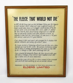
Text panel, Elders Limited, "The Fleece that would not die"
Text panel produced by Elders to accompany display of coat. In 1928 Mr Mal Groves took over the Dutchman Station near Port Augusta in South Australia. Whilst out riding in some rough country he came across a sheep that had been left by the previous owner of the station. As he carried shears with him, he sheared the sheep and left the fleece rolled up and partially covered by rocks and wood, as he had no bag to carry it back with him. He intended to come back for the fleece, but forgot about it until he came across it some forty years later. It was still in good condition (despite having experienced extreme temperatures and rainfall whilst in the open), so he showed it to Elders who arranged to display it at agricultural shows in Adelaide, Melbourne and Geelong. The Gordon Institute of Technology, Geelong, offered to spin the fleece into a fabric and make a coat for Mrs Groves. The fabric was tailored into a coat by Lindsay and McKenzie of Geelong and presented to Mrs Groves in July 1968 by the SA manager of Elder Smith Goldsbrough Mort Ltd. It is not know how the coat came to Elders from the Groves family, but Elders displayed the coat under the heading "The Fleece That Would Not Die" before donating it to the National Wool Museum in 1997. A video giving the history of the coat as well as this text panel used by Elders were also donated at the same time.Text panel with black and red text on cream paper, framed in wooden frame and glass, with hanging wire.shearing, elders limited, groves, mr mal groves, dutchman station, south australia -
 National Wool Museum
Video recording, Elders Limited, "The Fleece that would not die"
Video recording, produced to accompany display of coat. In 1928 Mr Mal Groves took over the Dutchman Station near Port Augusta in South Australia. Whilst out riding in some rough country he came across a sheep that had been left by the previous owner of the station. As he carried shears with him, he sheared the sheep and left the fleece rolled up and partially covered by rocks and wood, as he had no bag to carry it back with him. He intended to come back for the fleece, but forgot about it until he came across it some forty years later. It was still in good condition (despite having experienced extreme temperatures and rainfall whilst in the open), so he showed it to Elders who arranged to display it at agricultural shows in Adelaide, Melbourne and Geelong. The Gordon Institute of Technology, Geelong, offered to spin the fleece into a fabric and make a coat for Mrs Groves. The fabric was tailored into a coat by Lindsay and McKenzie of Geelong and presented to Mrs Groves in July 1968 by the SA manager of Elder Smith Goldsbrough Mort Ltd. It is not know how the coat came to Elders from the Groves family, but Elders displayed the coat under the heading "The Fleece That Would Not Die" before donating it to the National Wool Museum in 1997. A text panel giving the history of the coat as well as this video was also donated at the same time.Video recording, in a white case with Tasmanian Trades and Labour Council with compliments slip printed on yellow paper inserted into back sleeve.shearing wool - history, elders limited, groves, mr mal groves, shearing, wool - history -
 National Wool Museum
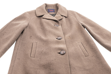
Coat, Lindsay and McKenzie, The Fleece That Would Not Die, 1968
This coat was produced from wool first shorn in c.1928. In 1928 Mr Mal Groves took over the Dutchman Station near Port Augusta in South Australia. Whilst out riding in some rough country he came across a sheep that had been left by the previous owner of the station. As he carried shears with him, he sheared the sheep and left the fleece rolled up and partially covered by rocks and wood, as he had no bag to carry it back with him. He intended to come back for the fleece, but forgot about it until he came across it some forty years later. It was still in good condition (despite having experienced extreme temperatures and rainfall whilst in the open), so he showed it to Elders who arranged to display it at agricultural shows in Adelaide, Melbourne and Geelong. The Gordon Institute of Technology, Geelong, offered to spin the fleece into a fabric and make a coat for Mrs Groves. The fabric was tailored into a coat by Lindsay and McKenzie of Geelong and presented to Mrs Groves in July 1968 by the South Australian manager of Elder Smith Goldsbrough Mort Ltd. It is not know how the coat came to Elders from the Groves family, but Elders displayed the coat under the heading "The Fleece That Would Not Die" before donating it to the National Wool Museum in 1997. A video giving the history of the coat and a text panel used by Elders were also donated at the same time.Coat, brown wool. Long sleeves, knee length with three circular brown buttons and two external pockets. Lined in brown satin, with a blue and red label at the base of the collar.Wording: Solo;Method: Embroidered;Location: Label at base of collar, inside coat Wording: PURE WOOL;Method: Printed;Location: Label on side seam, inside coatfashion wool - characteristics wool processing textile mills textile mills, lindsay and mckenzie elders limited gordon technical college, royal adelaide show - exhibition (31/08/2001 - 08/09/2001), groves, mr mal groves, mrs, dutchman station, south australia, fashion, wool - characteristics, wool processing, textile mills -
 The Beechworth Burke Museum
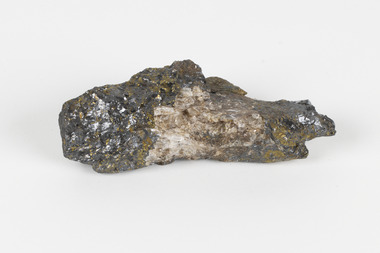
Geological specimen - Sphalerite, Unknown
Sphalerite or sphaelerite is named from the Greek word for 'treacherous' or 'deceiver' as specimens can vary widely in appearance, making them hard to visually identify. It is a zinc sulfide with the chemical composition (Zn,Fe)S, the most important ore of zinc. Specimens of sphalerite can contain iron as a substitute for up to 25% of the usual zinc present, as well as trace elements of gallium, cadmium, geranium and indium. Small amounts of arsenic and manganese may also be detected. Sphalerite is found in igneous, sedimentary and metamorphic rocks. It forms when carbonate rock encounters acidic, zinc-bearing fluid. It often forms in veins or in fissures of the existing rock, with colours and crystal shapes dependent on the composition of the the combining elements. It forms isometric crystal shapes including cubes, tetrahedrons, octahedrons, dodecahedrons. This specimen was collected in approximately 1852, in Broken Hill, NSW, as an adjunct to the Geological Survey of Victoria. It was donated to the Museum in 1868. Victoria and other regions of Australia were surveyed for sites of potential mineral wealth throughout the 19th Century. The identification of sites containing valuable commodities such as gold, iron ore and gemstones in a locality had the potential to shape the development and history of communities and industries in the area. The discovery of gold in Victoria, for instance, had a significant influence on the development of the area now known as 'the goldfields', including Beechworth; the city of Melbourne and Victoria as a whole.The specimen is significant as an examples of surveying activity undertaken to assess and direct the development of the mineral resource industries in Victoria and Australia, as well as the movement to expand human knowledge of earth sciences such as mineralogy and geology in the nineteenth century.A pipe-shaped specimen of sulfide-mineral zinc ore displaying patches of black, brown, beige and gold colouring. The main item has associated broken pieces. geological specimen, geology, geology collection, burke museum, beechworth, mineralogy, indigo shire, geological survey, sphalerite, sphaelerite, zinc ore, broken hill, nsw, victoria, galena, fluorite, chalcopyrite, lead, cadmium, gallium, germanium, indium, iron -
 Phillip Island and District Historical Society Inc.
Photograph Album, Kodak, Phillip Island Cemetery, c 1990
The Album was compiled by Nancy McHaffie late 1990's, with the assistance of Edith Jeffery's, with her book "Garden of Memories" and extensive knowledge of Phillip Island. The Cemetery lies back from the road and is surrounded by Manna Gums, rare Peppermint Gums, Blackwoods and other native trees. In all 25 acres of land were set aside as Crown Land in the land settlement of 1868. There are 6.2 acres of wetlands near the cemetery entrance.466-32: Stanley Stowel Kennon Sr. was born in Melbourne in 1852. He spent many years at Newhaven and Cowes. He was 24 years old when he spent six weeks on Seal Rocks obtaining Seal Oil. In 1888 he rescued Sir William Irvine and a friend when they were marooned on a small island whilst out fishing. He was presented with a gold watch and chain for his bravery. Stanley was known as one of the most capable and daring sailors ever connected to Phillip Island. He died in 1924 aged 72. 466-33: Lucy Cox was the wife of George Cox who was the first official mailman to Phillip Island. George had a love of the sea from boyhood serving as a British Sailor. He heard of the discovery of gold in Australia which brought him to Australia to try his luck. He built a hut on the foreshore opposite the Isle of Wight Hotel. He lived there until he disappeared; it is thought he drowned. Lucy died 3rd September 1888.phillip island cemetery, nancy mchaffie, edith jeffery, george cox, lucy cox, stanley kennon -
 4th/19th Prince of Wales's Light Horse Regiment Unit History Room
Potographs, Turkish Prisoners, c. 1918
A set of nine black & white photographs depicting mainly activities of Turkish prisoners. 1. Ten prisoners sitting in a circle preparing vegetables. On the back - "Preparing the daily stew". 2. A group of about 70 prisoners in ranks of four with hundreds more in the background. On the back "Led or fed up". 3. Three sets of 44 gallon drums set up for cooking with a line of 25 prisoners behind. On the back "One of the camp kitchens, prisoners, staff and interpreter". 4. An open plane with long lines of prisoners . On the back "Prisoners from Jenin to Lejjun". 5. A group of about 80 prisoners by a stream. On the back " The first batch of prisoners in Damascus district near Sasa". 6. Lines of graves decorated with rocks. On the back "Turkish Graveyard". 7. Another scene of the camp kitchen with a large gathering of prisoners and Light Horsemen. On the back "The stew issue". 8. A large gathering of prisoners, mainly sitting on the ground. On the back "Acres of prisoners at Tulkeram". 9. Graves of Turkish POW's who died of sickness Oct 18See descriptionphotos, turkish pow, ww1 -
 Bendigo Historical Society Inc.
Document - A HISTORY OF THE PARISH OF ST AUGUSTINE'S: MYERS FLAT
A history of the Parish of St Augustine's Myers Flat - The oldest Church in the Sandhurst Diocese by Fay Parker. A 7 loose- paged printed document covering - early history of Myers Flat; Myers Flat school; building and dedication of church/school (1864); enrolments of children; fund raising; Myers Flat Cricket Club; hotels in Myers Flat (& Brewery)); choir and missions at St Augustine's; teachers and students (incl. names of students in last years); restoration (1964/5); National Trust classification (1970); priests over the years ; names of families still attending St Liborious and St Augustine's with original forebears among first parishioners; bibliography; final page is a poem about ''St Augustine's'' written by Aimee Rees to celebrate the centenary of St Augustine's. B. Single typed page beginning ''My grandmother Anne Rocks was born at Myers Flat on November 2nd, 1867 '' with further information re great grandmother and great grandfather and (10) children of that family - no author given for this page (but could be Fay Parker???)Fay Parkerchurch, history, st augustines myers flat, myers flat school, cricket club, brewery, myers flat cricket club, st liborious, st augustine's, anne rocks. rev. dean hayes. right rev. bishop goold. rev. dr backhaus. st ausustine's poem. -
 Bendigo Historical Society Inc.
Photograph - Abbott family group, 1895
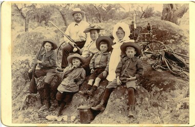
Richard Hartley Smith Abbott, company director, was born, probably in Bendigo, Victoria, around 1859, the son of Richard Hartley Abbott, also a company director, and Ann, née Smith. The young Richard was educated at Bendigo High School and then at St Andrews, Scotland. Returning to Australia, he became proprietor of the Abbott Supply Company, a director of the Sandhurst Building Society, the Bendigo Gas Company, and several local mining enterprises. He owned farms at Lyell, Mandurang and Eppalock, and was a pioneer of lucerne cultivation and tanning. In 1887, Abbott became a councillor for Strathfieldsaye Shire, a position he held for fifteen years. He was shire president (1901–02) and a Bendigo City councillor (1904–09; 1913–19), serving as Mayor of Bendigo between 1917 and 1918. Richard died in 1940. https://biography.senate.gov.au/richard-hartley-smith-abbott/ 'Preston Vale' was a property in Sedgewick. A sepia photo taken at Preston Vale of the Abbott family in 1895 including Richard Hartley Smith Abbott (Snr.) Mary Hannah (Gibbs) Abbott and their five oldest children, Richard Hartley Abbott born 1885, Inez Marie Abbott born 1886, William Norman Abbott born 1888, Harold Athelstone Abbott born 1889, and Kenneth Cyril Abbott born 1890. Two of the boys are wearing long sleeved striped collared shirts, one a scouting style coat and the youngest a collared shirt and all boys are in short pants with socks or stockings. Inez, is in a long sleeved dress with white smock with white bonnet. She is wearing boots. All others are wearing hats, Mrs Abbott's hat has a scrunched/folded ribbon on the brim. She is wearing a long sleeved light coloured blouse fastened at the neck The group is seated on an outcrop of granite rocks with parts of a buggy and horse tackle showing behind them. A lidded billy and scattered cups are on the ground in front. Mr Abbott, in shirt and long pants, is carrying a shot gun as is one of the boys. Both photos have 'Preston Vale Dec 26/95' written in ink on the reverse.abbott family, preston vale -
 Phillip Island and District Historical Society Inc.
Photograph Folder, The Rose Stereographs, Early 20th Century
Souvenir history of Phillip Island.A collection of black & white photographs in a souvenir folder. Photographs include: Koalas, Penguins, Seals, The Suspension Bridge, Cowes Pier, Cowes Beach, The Race Track, The Nobbies, Pyramid Rock, The Pinnacles and Forrest Cave. On the front of the folder: Cowes, Phillip Island. Greetings from Cowes, P.I. Inside and description of Phillip Island as shown on Photograph 281-12. 281.01. Koalas, or Australian Native Bears. 281-02. "Come on, Hurry, Baby's waiting." 281-03. View of Suspension Bridge, looking from San Remo to Phillip Island. 281-04. View from the Pier, Cowes. 281-05. On the Seal Rocks, Phillip Island, Vic. 281-06. Western Beach, Cowes, Phillip Island. 281-07. The straight, Racing Circuit, Cowes, Phillip Island. 281-08. the Nobbies, Phillip Island. 281-09. The Pyramide, Back Beach, Phillip Island. 281-10. The Pinnacles, Cape Woolamai, Phillip Island. 281-11. Forest Cave, Phillip Island, Vic. wildlife - koala, wildlife - seals, wildlife - penguins, the nobbies, the pinnacles, forrest caves, pyramid rock, cowes foreshore - cowes pier - phillip island, cowes beach phillip island, phillip island suspension bridge, phillip island race track, stan harris -
 Phillip Island and District Historical Society Inc.
Photograph - Post Cards, A. J. Murray, 1940's
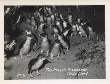
Part of a collection of photographs and postcards donated by Julie Barnett. Photos taken and purchased on her In-law's honeymoon during November 1946.12 Black & White Postcards various views around Phillip Island including the Penguin Parade, Suspension Bridge, Summerland Beach, Forrest Caves, The Nobbies and The Blowhole and Pyramid Rock.07. "The Penguin Promenade, Phillip Island" No. 9 08. "Photo Shop Series. The Jetty thro' the trees Cowes" 09. "Photo Shop Series. Phillip Island Bridge" 10. "Photo Shop Series. Phillip Island Bridge" 11. "Photo Shop Series. Forrest Caves. Phillip Island 12. "Photo Shop Series. Parade of the Penguins. Phillip Island" 13. "Photo Shop Series. Pyramid Rock. Phillip Island" 14. "Photo Shop Series. The Cascades at The Nobbies. Phillip Island" 15. "Photo Shop Series. Breakers at The Nobbies. Phillip Island" 16. "Photo Shop Series. The Nobbies and Seal Rocks. Phillip Island" 17. "Photo Shop Series. The Blowhole. Phillip Island" 18. "Photo Shop Series. Summerland Surf Beach. Phillip Island"wildlife - penguins, penguins coming ashore, penguins, the nobbies phillip island, the blowhole at the nobbies, the blowhole phillip island, pyramid rock, pyramid rock phillip island, cowes pier phillip island, cowes jetty, suspension bridge phillip island, phillip island suspension bridge, forrest caves phillip island, summerland surf beach phillip island, julie barnett -
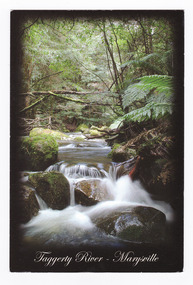 Marysville & District Historical Society
Postcard (item) - Colour postcard, Rosewood Photography, Taggerty River - Marysville, Pre 2009
A colour photograph of the Taggerty River at Marysville in Victoria.A colour photograph of the Taggerty River at Marysville in Victoria. This postcard was produced by Rosewood Photography as a souvenir of Marysville.The Cascading waters of Taggerty River The beautiful & scenic Taggerty River is a 10 minute drive from Marysville, Victoria./ Surrounded by tree ferns & mos covered rocks, the tranquil sounds of the flowing/ river are great place to visit while in Marysville. Photography & Design by/ Roswood Photography/ Mulgrave, Victoria/ [email protected]/ Tel:1300 769 922 Date Stamp 2004/ 6 PM SUNDAY/ Dear Norma & Rod/ All is beauty + peace here/ -the colours are simply/ beautiful every where./ I've done some pleasant/ walking + look forward/ to some more/ Frosty/ mornings perishing - but/ days lovely!!/ Take care - Love-/ Sar-jane A MR + MRS R McDONALD/ 24 PRINCETOWN RD/ MT WAVERLEY/ VIC 3149marysville, taggerty river, victoria, rosewood photography, postcard, souvenir -
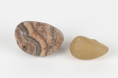 The Beechworth Burke Museum
Geological specimen - Agate and Quartz pebbles
Agate occurs when amygdales (gas pockets) form in the upper levels of basaltic lava flows. If these pockets or bubbles are iniltrated by water bearing silica in solution, the fluid dries and hardens in layers, forming round or egg shaped nodules or geodes within the rocky matrix. Agate is formed of a silica mineral chalcedony similar to quartz. Although relatively common and semi-precious, agate has been prized since at least 1450 BC - an intricately carved agate seal was found in the 2015 excavation of a grave belonging to a Mycenaeum priest or warrior near Pylos in Greece. Agate is also used in jewellery and other decorative or ritual purposes due to its often striking appearance. Quartz is found all over Australia, including Beechworth in Victoria. It is formed in deep-seated igneous rocks and crystallized through hot aqueous solutions. It can have two forms; Microcrystalline quartz or Crystalline quartz. Microcrystalline quartz is a fine grain quartz where crystalline quartz is often a large crystal. The colour of quartz can vary. These specimens were collected in Victoria in the vicinity of the Burke Museum. Victoria and other regions of Australia were surveyed for sites of potential mineral wealth throughout the 19th Century. The identification of sites containing valuable commodities such as gold, iron ore and gemstones in a locality had the potential to shape the development and history of communities and industries in the area. The discovery of gold in Victoria, for instance, had a significant influence on the development of the area now known as 'the goldfields', including Beechworth; the city of Melbourne and Victoria as a whole.The specimens are significant as examples of surveying activity undertaken to assess and direct the development of the mineral resource industries in Victoria and Australia, as well as the movement to expand human knowledge of earth sciences such as mineralogy and geology in the nineteenth century.Geological specimens of Agate and Quartz respectively; the fist-sized piece of Agate has peach/coral colouring with grey concentric patterning and the smaller piece of quartz is a uniform yellow/orange shade. Existing label: Local pebbles / (agate and / quartz / (yellowish) / egg-shaped). / BB geological specimen, geology, geology collection, burke museum, beechworth, agate, quartz, north-east victoria, indigo shire, geological surveys -
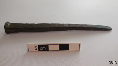 Flagstaff Hill Maritime Museum and Village
Functional object - Nail
This historic bronze nail dates back to 1840s when the ship Grange was built. Nails such as this one were used for boat building, as deck fasteners and many other uses. This nail was made at a time when the shanks of nails were usually machine cut but the heads were hand formed by blacksmiths. The nail was recovered from the shipwreck of the Grange in around 1968, 110 years after the Grange was wrecked (see below for further details on the Grange). It is part of the John Chance Collection. THE GRANGE, 1840-1858- The wooden barque ’Grange’ was a three-masted ship built in Scotland in 1840 for international and coastal trade. On March 22, 1858, the Grange set sail from Melbourne under Captain A. Alexander, carrying a cargo of ballast. The barque had left the Heads of Phillip Bay and was heading west along the Victorian coast towards Cape Otway. The ship struck Little Haley’s Reef at Apollo Bay due to a navigational error and was stuck on the rocks. The crew left the ship carrying whatever they could onto the beach. Eventually, the remains of the hull, sails and fittings were salvaged before the wreck of the Grange broke up about a month later. About 110 years later, in 1968, the wreck of the Grange was found by divers from the Underwater Explorers Club of Victoria. They were amazed to find a unique, six to nine pound carronade (type of small cannon) and a cannonball on the site. There have been no other similar carronades recorded. In that same year the anchor of the Grange was recovered by diver John Chance and Mal Brown.The nail is significant historically as an example of hardware used when building wooden ships in the early to mid-19th century. The nail is historically significant as an example of the work and trade of blacksmith. The nail also has significant as it was recovered by John Chance, a diver from the wreck of the Grange in the 1968. Items that come from several wrecks along Victoria's coast have since been donated to the Flagstaff Hill Maritime Village’s museum collection by his family, illustrating this item’s level of historical value. The nail is historically significant for its association with the 1840s wooden barque, the Grange. The Grange is an historical example of a Scottish built vessel used for international and coastal trader of both cargo and passengers in the mid-19th century. The Grange is an example of an early ship, designed with a wooden hull. It is significant as a ship still available to divers along the south coast of Victoria, for research and education purposes. The Grange is an example of a mid-19th century vessel that carried a weapon of defence onboard.Nail, bronze, round head, four-sided shank, tip flattened to a rounded wedge shape. The surface is pitted and rough. There is orange and blue concretion on the shank. The nail is bent. flagstaff hill, warrnambool, flagstaff hill maritime museum, maritime museum, shipwreck coast, flagstaff hill maritime village, great ocean road, west coast trader, apollo bay, mid-19th century shipwreck, the grange, scottish barque, little henty reef, captain a alexander, underwater explorers club of victoria, 1840s carronade, vhr 5297, coastal trader, wooden shipwreck, john chance, fastener, nail, square nail, machine cut mail, blacksmith, historic nail, bronze nail, carronade, mal brown -
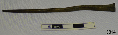 Flagstaff Hill Maritime Museum and Village
Functional object - Nail
This historic bronze nail dates back to 1840s when the ship Grange was built. Nails such as this one were used for boat building, as deck fasteners and many other uses. This nail was made at a time when the shanks of nails were usually machine cut but the heads were hand formed by blacksmiths. The nail was recovered from the shipwreck of the Grange in around 1968, 110 years after the Grange was wrecked (see below for further details on the Grange). It is part of the John Chance Collection. THE GRANGE, 1840-1858- The wooden barque ’Grange’ was a three-masted ship built in Scotland in 1840 for international and coastal trade. On March 22, 1858, the Grange set sail from Melbourne under Captain A. Alexander, carrying a cargo of ballast. The barque had left the Heads of Phillip Bay and was heading west along the Victorian coast towards Cape Otway. The ship struck Little Haley’s Reef at Apollo Bay due to a navigational error and was stuck on the rocks. The crew left the ship carrying whatever they could onto the beach. Eventually, the remains of the hull, sails and fittings were salvaged before the wreck of the Grange broke up about a month later. About 110 years later, in 1968, the wreck of the Grange was found by divers from the Underwater Explorers Club of Victoria. They were amazed to find a unique, six to nine pound carronade (type of small cannon) and a cannonball on the site. There have been no other similar carronades recorded. In that same year the anchor of the Grange was recovered by diver John Chance and Mal Brown. The nail is significant historically as an example of hardware used when building wooden ships in the early to mid-19th century. The nail is historically significant as an example of the work and trade of blacksmith. The nail also has significant as it was recovered by John Chance, a diver from the wreck of the Grange in the 1968. Items that come from several wrecks along Victoria's coast have since been donated to the Flagstaff Hill Maritime Village’s museum collection by his family, illustrating this item’s level of historical value. The nail is historically significant for its association with the 1840s wooden barque, the Grange. The Grange is an historical example of a Scottish built vessel used for international and coastal trader of both cargo and passengers in the mid-19th century. The Grange is an example of an early ship, designed with a wooden hull. It is significant as a ship still available to divers along the south coast of Victoria, for research and education purposes. The Grange is an example of a mid-19th century vessel that carried a weapon of defence onboard.Nail, bronze, oval head, four-sided shank, tip flattened to a rounded wedge shape. The surface is pitted and rough. There is orange and blue concretion on the shank. The nail is bent. flagstaff hill, warrnambool, flagstaff hill maritime museum, maritime museum, shipwreck coast, flagstaff hill maritime village, great ocean road, west coast trader, apollo bay, mid-19th century shipwreck, the grange, scottish barque, little henty reef, captain a alexander, underwater explorers club of victoria, 1840s carronade, vhr 5297, coastal trader, wooden shipwreck, john chance, fastener, nail, square nail, machine cut mail, blacksmith, historic nail, bronze nail, carronade, mal brown -
 Parks Victoria - Gabo Island Lightstation
Brackets
Stainless steel brackets off the wreck of the Gypsy Moth V, wrecked near the lighthouse on 19 December 1982. These brackets were used to hold wire stays to the mast or bowsprit. The comparatively recent relics have a reliable provenance to the yacht Gipsy Moth V, which ran ashore on rocks under the lighthouse on 18 December 1982. It was the yacht that carried Sir Francis Chichester (1901-1972) on his second world voyage in 1971. While sailing the 19m (63.5ft) vessel in the 1972 Transatlantic Race, Chichester became weakened by cancer and had to abandon the competition and died two months later. His son Giles sailed the yacht back to England. In December 1982 British skipper, Desmond Hampton chartered the yacht for the around the world, single handed race. He had been running second and was nearing the end of the second leg of the competition from Cape Town, South Africa to Sydney when the accident happened. After going to bed he set the yacht on self steering and it wedged itself into a crevice just below the lighthouse and broke up. Everything was salvaged except for the masts and the engine. Twenty five years later, in 2007, items salvaged from the wreck surfaced in regional Victoria in a display of the ‘Gipsy Moth V Collection’, which included wreckage as well as photographs. The information from the ‘Sail World’ website did not provide any further details about the exhibition or its organisers.Two similar stainless steel brackets; half tubes with diagonally protruding flat section with hole at end. End is rounded. -
 The Beechworth Burke Museum
Geological specimen - Olivine Crystals, Unknown
Olivine is mostly found on the Earth's surface in igneous rocks that are dark-coloured. It is common at divergent plate boundaries and at warm spots, such as volcanic areas. It crystalises and forms during the cooling of magma. Olivine is used in refractory sand, bricks, and gemstones. Olivine has been found on a number of meteorites, which might have originated from large asteroids or the mantle of a now-destroyed planet. This olivine crystal is thought to originate from Mount Noorat, with speculation that it could have originated from Mount Shadwell. Mount Noorat is a dormant volcano cone located in the Newer Volcanics Province of Victoria. Mount Noorat belongs to the Kirrae Wuurong people, who used the Mount as a place for meetings and gatherings prior to European settlement. Contact was first made between European settlers and the Indigenous people in 1841. The Mount has mostly been used for cattle and sheep grazing. Mount Shadwell is a well-known source of olivine and is the highest of a gathering of volcanic cones. The New Volcanic Province is located in South East Australia and covers 15000 square kilometres. It contains 400 explosive vents and small shield volcanoes. The last eruption is thought to have occurred 5000 years ago at Mount Gambier and Mount Schank. This olivine crystal has been identified as a volcanic bomb, which is a molten rock which was pushed out and ejected into the air when a volcano reupts. A rock needs to be larger than 65 mm in diameter to be classified as a volcanic bomb. This olivine volcanic bomb and its locality is historically and socially significant. The olivine was found in the Newer Volcanic Province, an area which contains over 400 dormant volcanoes. This olivine is one part of a volcanic bomb, which would have ejected when magma erupted out of a volcano. This specimen is part of a larger collection of geological and mineral specimens collected from around Australia (and some parts of the world) and donated to the Burke Museum between 1868-1880. A large percentage of these specimens were collected in Victoria as part of the Geological Survey of Victoria that begun in 1852 (in response to the Gold Rush) to study and map the geology of Victoria. Collecting geological specimens was an important part of mapping and understanding the scientific makeup of the earth. Many of these specimens were sent to research and collecting organisations across Australia, including the Burke Museum, to educate and encourage further study.A solid iron-magnesium silicate mineral with shades of green and brownburke museum, beechworth, geological, geological specimen, olivine, igneous rock, volcanic, gemstones, volcanic bomb, meteorites, asteroids, plantes, mount noorat, mount shadwell, indigenous, kirrae wuurong people, newer volcanics province, victoria, european settlement, eruption