Showing 93127 items matching "bright-victoria"
-
 Lakes Entrance Historical Society
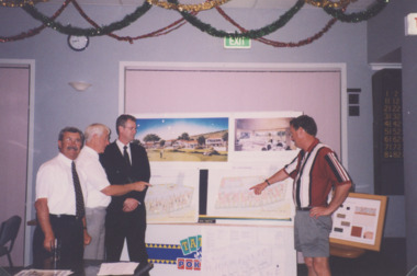
Photograph - Golf Houses residential development Golf Links Road Lakes Entrance Victoria, Lakes Post Newspaper, 1/12/1999 12:00:00 AM
Golf Houses residential development Golf Links Road Lakes Entrance Victoria - Proposed plan shown on notice boardColour photograph showing Matt Martino Bill Daniel Mike Hurst and Gary Jeal at the launch of Golf Houses residential development Golf Links Road Lakes Entrance Victoriatourism, land development -
 Marysville & District Historical Society
Photograph (Item) - Colour photograph, Travel Victoria, 2004
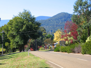
A colour photograph of the view looking down Sedgwick Street towards Lyell Street in Marysville in Victoria.A colour photograph of the view looking down Sedgwick Street towards Lyell Street in Marysville in Victoria.sedgwick street, lyell street, marysville, victoria, travel victoria, photograph -
 Victorian Interpretive Projects Inc.
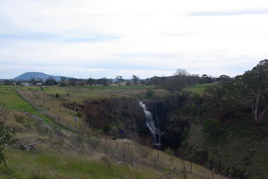
Photograph - Photograph - Colour, Clare Gervasoni, Lal Lal Falls, Victoria, 2014, 09/2014
Lal Lal Falls Reserve contains one of the most spectacular waterfalls in the Moorabool Shite. The watefall is part of the on Lal Lal Creek, a tributary of the Moorabool River. and plunges 30 metres from a high basalt column into a deep ravine. Culturally, the Falls are believed to be the earthly home of Bunjil, the All Father or Creator to most Victorian Aboriginal tribes. The name Lal Lal is thought to be Aboriginal for "dashing of waters". The Lal Lal Falls is listed on the Site Registry of Aboriginal Affairs Victoria as a spiritual place. in 1837 a Government Survey Party led by Frederick D'Arcy documented these Falls on the west branch of the Moorabool River. On the reserve opposite, a Race Meeting was held on every New Years Day from 1860 until 1938, attracting crowds of up to 20,000 people. A branch Railway Line was constructed from the Lal Lal station to the Racecourse to convey the crowds.Colour photographs of Lal Lal Falls near Ballarat, Victoria.lal lal falls, waterfall, lal lal, bunjil -
 Vision Australia
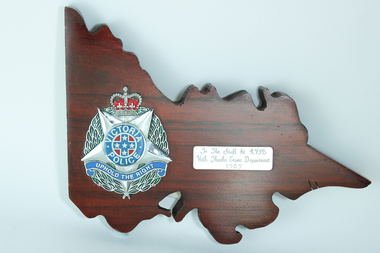
Photograph - Image, Victoria Police plaque, 1989
Wooden plaque in the shape of Victoria with the Victorian Police symbol (5 point star, surrounded by green leaves, topped with a red crown, round circle in the middle of the star containing the words 'Victorian Police' around a blue cross on a red background with 5 stars on the cross, and 'Uphold the Right' under the circle), to the left. The inscription to RVIB is on the right.Wooden plaque in shape of Victoria with police emblem on left sideTo the Staff of RVIB With Thanks Crime Department 1989royal victorian institute for the blind, nameplates -
 Marysville & District Historical Society
Photograph (Item) - Colour photograph, Travel Victoria, 2004
A colour photograph of Murchison Street in Marysville in Victoria.A colour photograph of Murchison Street in Marysville in Victoria.murchison street, marysville, victoria, photograph -
 Marysville & District Historical Society
Photograph (Item) - Colour photograph, Travel Victoria, 2006
A colour photograph of Murchison Street in Marysville in Victoria.A colour photograph of Murchison Street in Marysville in Victoria.murchison street, marysville, victoria, photograph -
 Marysville & District Historical Society
Photograph (Item) - Colour photograph, Travel Victoria, 2006
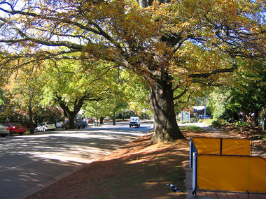
A colour photograph of Murchison Street in Marysville in Victoria.A colour photograph of Murchison Street in Marysville in Victoria. Shows the view looking down Murchison Street from Pack Road. The buildings that can be seen in the photograph were all destroyed in the 2009 Black Saturday bushfires.murchison street, pack road, marysville, victoria, photograph, 2009 black saturday bushfires -
 Marysville & District Historical Society
Photograph (Item) - Colour photograph, Travel Victoria, 2006
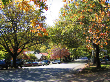
A colour photograph of Murchison Street in Marysville in Victoria.A colour photograph of Murchison Street in Marysville in Victoria. Shows the view looking down the street towards the F.J. Barton Bridge. All the buildings that can be seen in the photograph were destroyed in the 2009 Black Saturday bushfires.murchison street, marysville, victoria, photograph, 2009 black saturday bushfires, f.j. barton bridge -
 Marysville & District Historical Society
Photograph (Item) - Colour photograph, Travel Victoria, 2006
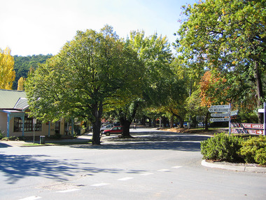
A colour photograph of Murchison Street in Marysville in Victoria.A colour photograph looking up Murchison Street in Marysville in Victoria. The view is looking up the street from the roundabout at the corner with the Marysville-Buxton Road.murchison street, marysville, victoria, photograph, 2009 black saturday bushfires -
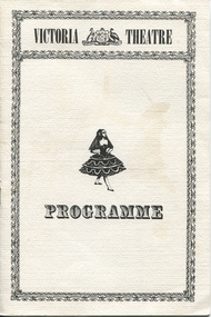 Ballarat Heritage Services
Ephemera - Program, Victoria Theatre Program, 1980s
The original Victoria Theatre opened on 16 February 1856 with a season by Lola Montez. She performed several farces and her famous spider dance, delighted the diggers and enraged the sensibilities of respectable people, with Henry Seekamp in the famous "whipping" incident with Montez in Ballarat. The program consisted of popular melodramas, farces and hits such as Rob Roy, The Lady of Lyons and the Count of Monte Cristo. The nautical drama Black-Eyed Susan was also very popular. This production "The Piper and Red riding Hood" was performed by The Mid-Night Players (Janet Low, Fay Jones, Natalie Jones, Fiona Hanrahan, Elizabeth Dale, Mark Jones, Bruce Roberts, Geoff Wallis, Matthew Brooks, Andrew Dark and Tom Rendall) at the replica Victoria Theatre at Sovereign Hill, Ballarat.A5 booklet with black ink printing on white card and paper.VICTORIA THEATRE THE PIPER AND RED RIDING HOOD THE MID-NIGHT PLAYERS ballarat, drama, melodrama, the piper and red riding hood, teh mid-night players, janet low, fay jones, natalie jones, fiona hanrahan, elizabeth dale, mark jones, bruce roberts, geoff wallis, matthew brooks, andrew dark, tom rendall, victorian theatre, sovereign hill -
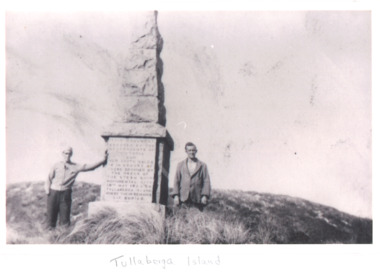 Lakes Entrance Historical Society
Photograph, S S Monumental City May Memorial on Tullaberga Island off Mallacoota Victoria, 1930 c
John Gerald Gray and another man standing beside the memorial dedicated to those drowned by the wreck of S S Monumental City May 1853 on Tullaberga Island off Mallacoota VictoriaBlack and white photograph taken of memorial dedicated to those drowned by the wreck of S S Monumental City May 1853 on Tullaberga Island off Mallacoota Victoriaroads and streets, transport -
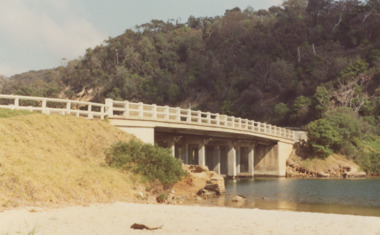 Lakes Entrance Historical Society
Photograph - North Arm bridge Lakes Entrance Victoria, M Fish, 1970 c
concrete bridge over North Arm taken from Eastern side of bridge southern shore of North Arm Lakes Entrance Victoria. Bridge built 1916 to 1917 demolished after opening of new bridgeColour photograph of concrete bridge over North Arm taken from Eastern side of bridge southern shore of North Arm Lakes Entrance Victoriabridges, topography -
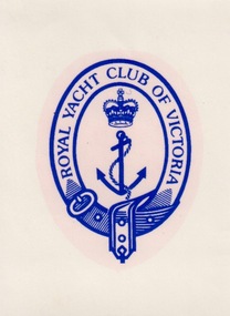 Federation University Historical Collection
Sign - Sign - Stickers, ZILLES COLLECTION: Stickers and stencils for Royal Yacht Cub and Nap Silentflo
Zilles Printers was begun by Lewis Zilles in the early 1930s. It was in McKenzie Street Ballarat. His son Jeffrey also became a printer - letterpress, offset and screen printer. The business became Zilles Printers/Graphics and was in Armstrong Street and later Bell Street Ballarat. Sticker produced are for the Royal Yacht Club of Victoria and Nap Silentflow - "The Experts in Noise Control". They are based in Oakleigh Victoria and manufacture acoustic louvres.Small white sticker with bright blue print and symbol.1 ROYAL YACHT CLUB OF VICTORIA around shield shape - formed by belt and buckle. Anchor and crown in centre part. .2 Arch shape with radiating line representing airflow. NAP SILENTFLO underneath.zilles printers, stickers, royal yacht club of victoria, nap silentflo, acoustic louvres, ballarat -
 Marysville & District Historical Society
Photograph (Item) - Colour photograph, Travel Victoria, 2004
A colour photograph of the view looking up Pack Road from the corner with Murchison Street in Marysville in Victoria.A colour photograph of the view looking up Pack Road from the corner with Murchison Street in Marysville in Victoria.pack road, murchison street, marysville, victoria, travel victoria, photograph -
 Vision Australia
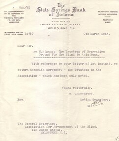
Letter - Text, Letter from State Savings Bank of Victoria to Association for the Blind, 1943, March 9, 1943
This letter was sent by The State Savings Bank of Victoria to General Secretary for the Association for the Advancement of the Blind, dated 9th March, 1943. It reads "Dear Sir, re: Mortgage: The Trustees of Recreation Ground for the Blind to this Bank. With reference to your letter of 1st instant, we herewith return agreement - the Trustees to the Association - which has been duly noted. Yours faithfully, G. Cartwright, Acting Secretary. 1 typed bank with State Savings Bank of Victoria letterheadassociation for the advancement of the blind, kooyong club house -
 Surrey Hills Historical Society Collection
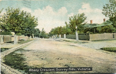
Postcard, Albany Crescent,Surrey Hills, Victoria Postcard
We hold 2 copies of this post card, the image of which which had been hand-tinted. The tree guards along the street prevented horses from browsing on their bark and leaves. The street on the right is probably Beatrice Avenue. SLV collection dates the post card as c1906.A coloured stamped postcard identified as Albany Crescent, Surrey Hills, Victoria showing the tree plantings on the naturestrips, gutters and houses with picket fences.SHP2213a Postcard front "Albany Crescent, Surrey Hills, Victoria". On the back is a message addressed to Mr N Smith at Phillip Island from "Ada". SHP2213b Received 2001 See our postcard print also/ From Julie Jones Heritage Officer Whitehorse/ after Heritage Trails published/ Have an original card already.albany crescent, surrey hills, ada, mr n smith, phillip island, post cards, 1901-1910 -
 Tatura Irrigation & Wartime Camps Museum
Photograph, Mactier Gardens and Victoria Hotel, Hogan Street, Tatura
Shows picture of Mactier Gardens and Victoria Hotel, Hogan Street, Tatura,.Colour photograph showing Mactier Gardens (on left) and Victoria Hotel (on right) Hogan Street, Tatura. Photograph stuck onto piece of white cardboard. hogan street tatura, mactier gardens tatura, victoria hotel tatura -
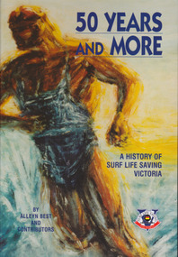 Warrnambool and District Historical Society Inc.
Book, BPA Print group Pty Ltd, 11 Evans St Burwood, Vic 3125, 50 Years and More A History of Surf Life Saving Victoria, First published 2002
History of Life Saving Victoria for over 50 yearsBlue and gold hard cover with stylized figure of life saver on front cover with multi coloured blue cover on back with small boxed copy of front cover figure. Taken from painting Beltman and Co by Brian St Alban Smith 1958. 548 pages followed by lists of award winners both individuals and clubs. Title and authors in dark blue text.History of Life Saving Victoria for over 50 yearswarrnambool, surf life saving victoria, surf championships, shark attacks, surf boats -
 Greensborough Historical Society
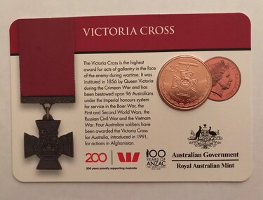
Commemorative Coin, Royal Australian Mint, Victoria Cross, 2017_
Victoria Cross for Australia was introduced in 1991 for actions in Afghanistan. Corporal Cameron Baird was the 100th Australian to receive the award This coin is one of a series "Legends of ANZACS", uncirculated, with a value of 25 cents.Bronze coin featuring an Australian Victoria Cross, laminated, mounted on card printed in colour both sidesLogos of Westpac, 100 years of ANZAC, and Legacy, with photographs of Albert Jacka and Cameron Baird, VC recipients.victoria cross, coins, commemorative coins -
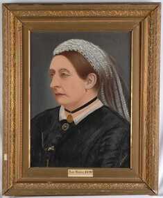 Glenelg Shire Council Cultural Collection
Painting, Queen Victoria, 1897
CEMA Art Collection Previously located in History HousePortrait of Queen Victoria depicting her torso and head. She looks to her right and is shown in an almost profile view. Dressed in black with a white collar, she wears a blue and white band in her hair. She wears a small gold earring, black choker with gold locket and a brooch with a man's portrait. The work has a gilded frame with some decoration and exposed canvas.Front: J.A.BRIGGS Queen Victoria, 1838-1901 Back: Painted by J A Briggs 1897queen victoria, 1800s, portrait, portrait painting, female, female portrait -
 Marysville & District Historical Society
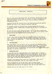
Flyer (Item) - Information Flyer, Forests Commission, Victoria, FOREST WALKS - MARYSVILLE, 1918-1983
An information flyer that was produced as a guide to the forest walks in and near Marysville by the Forests Commission of Victoria. The Forests Commission Victoria (FCV) was the main government authority responsible for management and protection of State forests in Victoria, Australia between 1918 and 1983. The Commission was responsible for ″forest policy, prevention and suppression of bushfires, issuing leases and licences, planting and thinning of forests, the development of plantations, reforestation, nurseries, forestry education, the development of commercial timber harvesting and marketing of produce, building and maintaining forest roads, provision of recreation facilities, protection of water, soils and wildlife, forest research and making recommendations on the acquisition or alienation of land for forest purposes″. An extensive network of walking tracks surrounds Marysville and they offer a variety of walks ranging in various levels of difficulty. This information flyer provides information such as the level of difficulty for six suggested walks around Marysville.An information flyer that was produced as a guide to the forest walks in and near Marysville by the Forests Commission of Victoria.marysville, victoria, australia, forest walks, forests commission victoria, beauty spot walk, tree fern gully walk, michaeldene track, keppel track, woods lookout track -
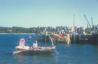 Lakes Entrance Historical Society
Photograph - Centenary Celebrations Lakes Entrance Victoria. c1958, 1958
Henley on the Lakes taken from Eastern Wharf during Centenary Celebrations Lakes Entrance Victoria. c1958 Colour photograph of decorated boats for Henley on the Lakes taken from Eastern Wharf during Centenary Celebrations Lakes Entrance Victoria. c1958. Similar colour photograph at Regatta 04274.1 . Plus 3 Black and white photos township, people, waterways, gippsland lakes, celebrations -
 Marysville & District Historical Society
Photograph (Item) - Colour photograph, Travel Victoria, 2006
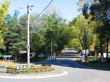
A colour photograph of Murchison Street in Marysville in Victoria.A colour photograph of Murchison Street in Marysville in Victoria. The photograph shows the corner of Murchison Street and Pack Road in Marysville.murchison street, marysville, victoria, photograph -
 Ringwood and District Historical Society
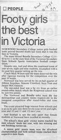
Newspaper, Scrapbook Clipping, Library Collection, Ringwood, Victoria
Newspaper Clipping from "The Mail", 12-9-1995, P 17, "Footy girls the best in Victoria"Norwood Secondary College junior girls football team proved beyond doubt last week that it was the best in Victoria. The team blitzed Benalla Secondary College 12.11-83 to -0.1-1 in the state final of the Victorian Secondary State Schools Sports Association football competition. -
 Lakes Entrance Historical Society
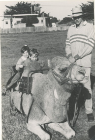
Photograph - Camel rides on the Esplanade Lakes Entrance Victoria, Lakes Post Newspaper, 1/06/1990 12:00:00 AM
cameleer and two children on resting camel, Pioneer Skills Day, taken between Caltex Service Station and State Bank building Esplanade Lakes Entrance VictoriaBlack and white photograph showing cameleer and two children on resting camel, Pioneer Skills Day, taken between Caltex Service Station and State Bank building Esplanade Lakes Entrance Victoriatourism, animals -
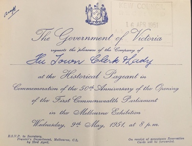 Kew Historical Society Inc
Document (item) - Invitation, Government of Victoria, Historical Pageant in Commemoration of the 50th Anniversary of the Opening of the First Commonwealth Parliament in the Melbourne Exhibition, 1951
The Municipality of Kew (1860-1863), the Borough of Kew (1863-1910), the Town of Kew (1910-1921) and the City of Kew (1921-1994) were local government instrumentalities in the State of Victoria. In 1994, the City of Kew was amalgamated, together with the former Cities of Camberwell and Hawthorn, into the new City of Boroondara (1994- ). Like other local government entities of the period, Kew was administered by town clerks. The two notable town clerks in Kew's history were H. H. (Henry Hirst) Harrison (1868-1955) and W. D. (William Dickie) Birrell (1899-1974). Harrison was appointed to the position in 1901 and retired in 1938 after 37 years. Birrell, appointed Acting Town Clerk in 1921, became Town Clerk in 1938, following Harrison's retirement. He continued in this role until his retirement in 1966.This card is part of an historically significant civic collection, containing hundreds of separate invitations, documents, greeting cards, programmes and tickets issued and/or collected by successive town clerks. Items in the collection illuminate the political, social and cultural history of the district. As a continuous record, ranging across most decades of the Twentieth Century, they reveal changing tastes in design, values and relationships in the history of local government in Victoria.THE GOVERNMENT OF VICTORIA / REQUESTS THE PLEASURE OF THE COMPANY OF / The Town Clerk and Lady / AT THE HISTORICAL PAGEANT IN / COMMEMORATION OF THE 50TH ANNIVERSARY OF THE OPENING / OF THE FIRST COMMONWEALTH PARLIAMENT / IN THE MELBOURNE EXHIBITION / WEDNESDAY 9TH MAY, 1951, AT 8 P.M. / RSVP TO SECRETARY, PREMIER'S DEPARTMENT, MELBOURNE C.2. BY 23RD APRIL. / ON RECEIPT OF ACCEPTANCE RESERVATION CARDS WILL BE FORWARDED.civic invitations -- kew (vic), civic ephemera - city of kew -- government of victoria, commemoration of the sitting of the first parliament, exhibition buildings -- melbourne (vic.) -
 Lakes Entrance Historical Society
Photograph, New Works cottages Lakes Entrance Victoria, 1/06/1989 12:00:00 AM
New Works cottages originally built for John Carpenter and George Carpenter of Lakes Entrance Victoria. Colour photograph of two of the New Works cottages originally built for John Carpenter and George Carpenter of Lakes Entrance Victoria. Also two other colour photographs of John and George Carpenters original homes with many people on front verandah genealogy, historic houses, settlement -
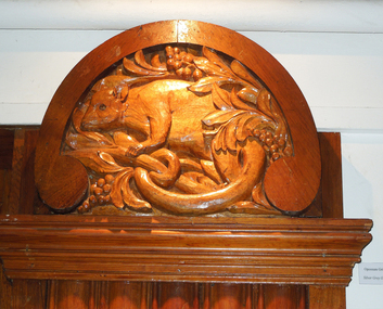 Federation University Historical Collection
Photograph - Photograph - Colour, Sandra Opie, Victoria School, Villers Bretonneux, 18/05/2012
Built in 1923-1927, the school is the gift from the children of the state of Victoria, Australia, to the children of Villers-Bretonneux as proof of their love and good-will towards France. Twelve hundred Australian soldiers, fathers and brothers of these children, gave their lives for the heroic recapture of the town on April 24th and 25th, 1918. On the front of the building there are two plaques (one in French and one in English) referring to this. In the School Yard, as well as an Aboriginal style mural created by the students of the school and inaugurated on ANZAC Day 2009, is an inscription over the porch on a green background in yellow writing saying : DO NOT FORGET AUSTRALIA Due to the strong bond of friendship between the Australian population and the inhabitants of Villers-Bretonneux. This message expresses the need to remember and show gratitude. Also situated in the school is the Victoria Hall, with its wooden paneling, co-ordinated by the Ballarat Technical Art School with most of the carving being undertaken by Australian sculptor John Grant of Daylesford Technical College in Victoria. The carvings represent fauna and flora from Australia. (http://www.museeaustralien.com/en/?Victoria_school, accessed 04/02/2014)Photographs of each of the Pilister at Victoria School, Villers Bretonneux. Each pilister is carved with an Australian Animal.villers-bretonneux, ballarat technical art school, victoria school, victoria hall, world war, world war 1, australian animals, possum, cockatoo, kookaburra, platypus, lyrebird, koala -
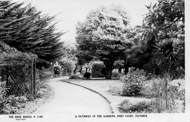 Port Fairy Historical Society Museum and Archives
Postcard, The Rose Series / The Rose Stereographs, Entrance to the Gardens Port Fairy Victoria, 1926
The Port Fairy Botanical Gardens were formed in 1856 making it one of the earliest gardens in Victoria. The first curator was James Prior, he was paid fifty-two pounds per annum. He was an outstanding curator having been apprenticed to the trade in England at the age of 12, his brother Edward in later years was the Curator of the Koroit Gardens. Prior retired in 1903. During the years of his curatorship Port Fairy was said to have the best gardens outside the city of Melbourne, he was constantly in touch with Baron Von Mueller and later Guilfoyle of the Royal Botanical Gardens of Melbourne. In the early years plants from all over the world were planted here with varying rates of success many of them sent by Baron Von Mueller. In the 1930’ and 40’s the gardens were still very beautiful, and the curator was Roy Manuell. The beautiful iron gates at the entrance were destroyed in the 1946 floods and were replaced in 1989 using some of the material from the original gates. From the 1950’s on the gardens went into a state of decline, much being taken up by the caravan park until in 1986, after a public meeting ‘Friends of the Gardens’ was founded when the entrance section was restored. Black and white Photograph of the main path through the botanical Gardens with the arbour to the left and mature trees and lawn on the rightEntrance to the Gardens Port Fairy Victoriagardens - entrance, path, arbour, trees, griffith street -
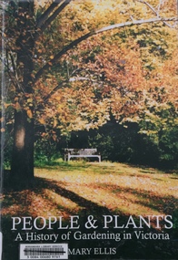 Kew Historical Society Inc
Book, Mary Ellis, People & Plants: A history of gardening in Victoria, 2003
Fish Creek., Victoria : Mary Ellis : c2003 172 p. : ill.(some col.)., ports. : 30 cm. non-fictiongardening - victoria - history, mary ellis, gardens -- victoria -- history., gardeners -- victoria -- biography.