Showing 968 items matching "dam"
-
 Kiewa Valley Historical Society
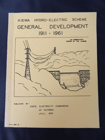
Book - Kiewa Hydro Electric Scheme 1911-1961, Kiewa Hydro-Electric Scheme /General Development / 1911-1961, July, 1973
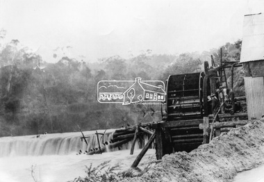
The book is an abbreviated history of the Kiewa Hydro Electric Scheme.This book summarises the stages of the Kiewa Hydro Electric Scheme from its conception in 1911 through to 1961. The newspaper cutting gives additional information about Rocky Valley Dam.Yellow cardboard book with front cover of black writing and sketch of power lines and spillway in the mountains. 2 staples are covered along the spine with tape. There are 22 pages. 2 copies Inside one copy there is a newspaper cutting entitled "Main Dam in Kiewa Scheme Finished" and later published pages of 1. Floras of Bogong 2. Geology of Kiewa Area 3. Fauna and 4. 'Brief history of the Kiewa Scheme. An abbreviated History of the SchemeOn the newspaper cutting hand written "Burnett 1959 Later than May."kiewa hydro electric scheme. mt beauty. dederang. bogong. mckay creek power station. west kiewa power station. clover power station. secv. rocky valley dam. flora. fauna. geology. -
 Bendigo Historical Society Inc.
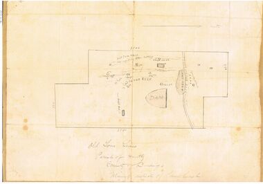
Map - OLD TOM MINE, WHIPSTICK
2 copies ( A4 and A3) of Old Tom lease. Map shows Old Tom Reef, old working open cutting, shaft 150 ft., Easter Reef, dam sand heap, water race, 3 other shafts, 120ft., 90ft., and 500 ft. marked on map. Stamped on map '64.3.34' Written on bottom of map in handwriting ' Old Tom Lease, Parish of Huntly, County of Bendigo, Mining district of Sandhurst'bendigo, mining, old tom lease map -
 Bendigo Historical Society Inc.
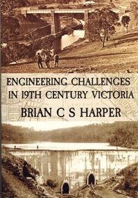
Book - ENGINEERING CHALLENGES IN 19TH CENTURY VICTORIA
Engineering Challenges in 19th Century Victoria by Brian C S Harper, or Brian Harper, soft cover 256 pages with black and white photographs. Book includes information on the construction of the Bendigo Railway Line, Coliban Water Scheme, Lower Stony Creek Dam, the Saltwater Railway Bridge, and the Taradale Railway Viaduct. Transferred to Specimen Cottage for use June 2016 Missing from Specimen Cottage. Check sale items 8.12.22Brian C. S. Harperbooks, technical, engineering -
 Bendigo Historical Society Inc.
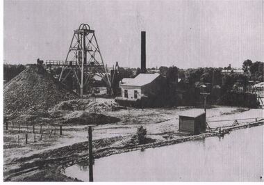
Photograph - BLACK AND WHITE PHOTOGRAPH OF THE NORTH DEBORAH MINE
North Deborah Mine in Eve Street, Bendigo, operated between 1937 and 1954. In that time it produced 128,000 ounces of gold.Black and white photograph of the North Deborah Mine, showing the poppet head, mullock heap to the left, man at the end of railway at the first level, does not show cables from the engine house to the wheels on top of the poppet, water tank at the side of the engine house, farm style corner of a fence at left of photo, small shed housing a pump for water, right foreground is a dam for water waiting to be converted to steam to operate the cable winder.mining, surface equipment, north deborah mine -
 Bendigo Historical Society Inc.
Newspaper - JENNY FOLEY COLLECTION: WHEN IT WAS FULL
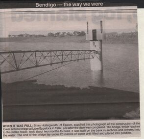
BHS CollectionBendigo advertiser ''The way we were'' from 2003. When it was full: Brian Hollingworth of Epsom, supplied this photograph of the construction of the tower access bridge at lake Eppalock in 1962, just after the dam was completed. The bridge, which reaches to the intake tower, took about two months to build. It was built on the bank in sections and lowered into the water. The end of the bridge lay under 20 metres of water until lifted and placed into position. The clip is in a folder.newspaper, bendigo advertiser, the way we were -
 Bendigo Historical Society Inc.
Newspaper - AUSTIN COLLECTION: Koch's Pioneer Gold Mine, Long Gully
Koch's Pioneer Quartz Mining and Crushing Company was officially registered on June 30th., 1871 (Government Gazette No. 45, 1871). It operated at Long Gully, the first Manager was Andrew Lewis. Nominal capital was 90,000 pounds in thirty thousand shares of 3 pounds each. The initial partnership in a quartz crushing plant between Henry Koch, Simon Albert and Charles Wallin was dissolved in 1860 with Koch becoming the sole owner. In 1866 the crushing plant consisted of a 50 hp engine and 48 stamping heads capable of crushing 600 tons of quartz per week. By 1902 there were 72 stamps and this was by far the largest crushing plant in the area, serving many quartz mines. Henry Koch (1800-1889) was a German sailor who signed off when his ship reached Melbourne in 1851. Having heard of the gold discovery he proceeded to Bendigo where he was initially employed in puddling in the Myers Flat area. He was soon employed and then made partner in a quartz crushing plant that he became sole owner of in 1860. He was also landlord at the British and American Hotel and the Silver Mines Hotel. HE also started the Perseverance United gold claim. He married Anna Maria Theresia Heinz in 1857. In 1872 he sold the crushing plant for 75,000 pounds and took his family back to Germany. He resumed his trade as a ship builder although he maintained many Bendigo mining interests.Two sepia coloured images on paper, possibly taken from book. Top image: Koch's 'Pioneer' Quartz Crushing Works - Long Gully, printed under image. Image shows mining dam in foreground, large two storey mine building in middle background, two mine chimney on right hand side. Bottom image; interior of crushing battery. Printed on bottom ' Quartz Crushing Batteries & etc. Koch's Pioneer'. gold mining, koch's pioneer crushing battery, long gully, perseverance g.m. co., henry koch -
 Federation University Historical Collection
Book, McGraw-Hill Book Company, Hydraulics: A Text on Practical Fluid Mechanics, 1937
The book was used by Charles Bacon who studied at the University of Nevada in the late 1930s/early 1940s. Bacon worked at Bunker Hill Mines and Kellogg Idaho, before arriving in Australian in 1951. He worked for CN Myers, a company involved with paper converting. CN Myers was a family business (on Charles Bacon's maternal line).Blue hard-covered book of 460 pages. Chapters include Properties of Fluids, intensity of Pressure, Hydrostatic Pressure of Areas, Dams, Kinematics of fluid Flow, Dynamics of Fluid Flow, Applications of Hydrokinetics, Friction Losses in Pipes, Flow Through Pipes, Uniform Flow in Open Channels. Nonuniform Flow in Open Channels, Unsteady Flow, Dynamic Forces, Description of the Impulse Wheel, Theory of the Impulse Wheel, water Power Plants, centrifugal Pump and more.Inside Front Cover "Charles Bacon, Mackay school of Mines Reno, Nevada."charles bacon, mining engineering, metallurgy, university of nevada, mackay school of mines -
 Bendigo Historical Society Inc.
Document - STATE RIVERS AND WATER SUPPLY COMMISSION : GENERAL DESCRIPTION AND PARTICULARS OF EPPALOCK PROJECT, 1/08/1961
State Rivers and Water Supply Commission. Seven-page typed document titled 'General description and particulars of the Eppalock Project.' Subheadings: General, Administration and Works Installation, Field laboratory, Construction programme, Design statistics, Major items of plant in use on the project, Progress to 1st August 1961, Eppalock Reservoir Locality Plan (diagram), Eppalock project works area & arrangement plan (diagram), Eppalock Project cross section of dam along? tunnel (diagram).state infrastructure, water supply, coliban system, state rivers and water supply commission. coliban system. eppalock. -
 Eltham District Historical Society Inc
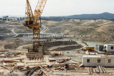
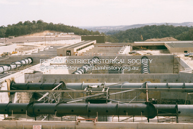
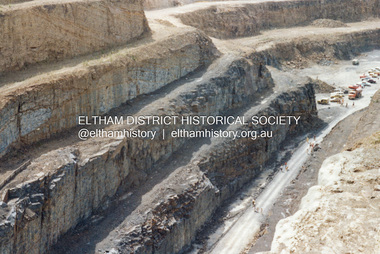
Photograph - Colour Print, Lewis Tulk, Construction Winneke Reservoir and treatment plant / Melbourne and Metropolitan Board of Works, c.1981
Sugarloaf Reservoir is situated on former farmland. This large water storage was completed in 1982 and serves Melbourne's northern suburbs. Within the visitor areas are two picnic grounds and other recreational facilities. Below its massive rock embankment is located the Winnecke Treatment Plan designed to purify its water before being piped into Melbourne. The dam partly inundated the old firing ranges of the former Christmas Hills Rifle Club. Source: Christmas Hills Now and then: Yarra Glen & District Historical Society, 2004.lewis tulk collection, construction, sugarloaf reservoir, winnecke dam -
 Eltham District Historical Society Inc
Photograph, Remains of the old Water Wheel and Battery, Warrandyte, 1934
A short distance upstream from the old wooden Warrandyte Bridge, the Yarra river was at one time dammed to give power to a large wooden waterwheel which drove a plant for crushing gold. Up until around 1908 the waters of the Yarra, pent up by a stone weir, forced their way past this old wheel turning it to crush the precious quartz. In 1925 the reamins of the State Battery were removed. The large water wheel (thanks to the forethought of a local resident, Mr. P. Mackie) was left in its position.This photo forms part of a collection of photographs gathered by the Shire of Eltham for their centenary project book,"Pioneers and Painters: 100 years of the Shire of Eltham" by Alan Marshall (1971). The collection of over 500 images is held in partnership between Eltham District Historical Society and Yarra Plenty Regional Library (Eltham Library) and is now formally known as the 'The Shire of Eltham Pioneers Photograph Collection.' It is significant in being the first community sourced collection representing the places and people of the Shire's first one hundred years.Digital image 4 x 5 inch B&W Negshire of eltham pioneers photograph collection, warrandyte, water wheel, caledonia battery, state battery, warrandyte battery -
 Eltham District Historical Society Inc
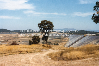
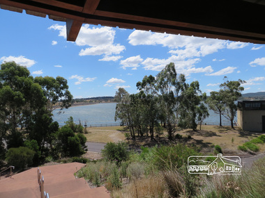
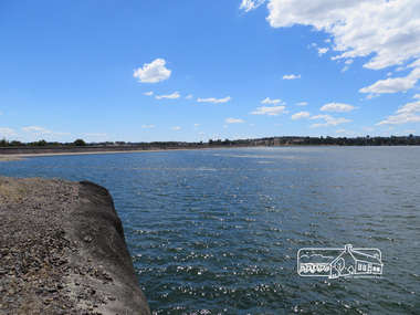
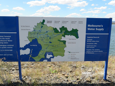
Photograph, Sugarloaf Reservoir, Christmas Hills, 16 January 2015, 16 January 2015
Sugarloaf Reservoir is situated on former farmland. This large water storage was completed in 1982 and serves Melbourne's northern suburbs. Within the visitor areas are two picnic grounds and other recreational facilities. Below its massive rock embankment is located the Winnecke Treatment Plan designed to purify its water before being piped into Melbourne. The dam partly inundated the old firing ranges of the former Christmas Hills Rifle Club. Source: Christmas Hills Now and then: Yarra Glen & District Historical Society, 2004. Born Digitalchristmas hills, sugarloaf reservoir -
 Eltham District Historical Society Inc
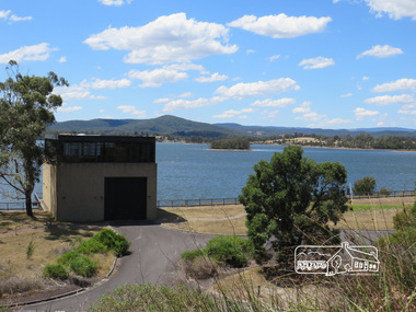
Photograph, Sugarloaf Reservoir, Christmas Hills, 16 January 2015, 16 January 2015
Structure at Sugarloaf. Sugarloaf Reservoir is situated on former farmland. This large water storage was completed in 1982 and serves Melbourne's northern suburbs. Within the visitor areas are two picnic grounds and other recreational facilities. Below its massive rock embankment is located the Winnecke Treatment Plan designed to purify its water before being piped into Melbourne. The dam partly inundated the old firing ranges of the former Christmas Hills Rifle Club. Source: Christmas Hills Now and then: Yarra Glen & District Historical Society, 2004. Born Digitalchristmas hills, sugarloaf reservoir -
 Eltham District Historical Society Inc
Photograph, Sugarloaf Reservoir, Christmas Hills, 16 January 2015, 16 January 2015
Sugarloaf Reservoir is situated on former farmland. This large water storage was completed in 1982 and serves Melbourne's northern suburbs. Within the visitor areas are two picnic grounds and other recreational facilities. Below its massive rock embankment is located the Winnecke Treatment Plan designed to purify its water before being piped into Melbourne. The dam partly inundated the old firing ranges of the former Christmas Hills Rifle Club. Source: Christmas Hills Now and then: Yarra Glen & District Historical Society, 2004. Born Digitalchristmas hills, sugarloaf reservoir -
 Eltham District Historical Society Inc
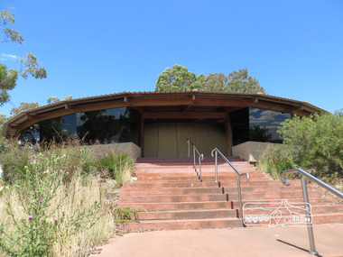
Photograph, Sugarloaf Reservoir, Christmas Hills, 16 January 2015, 16 January 2015
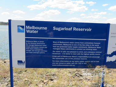
Sugarloaf Reservoir is situated on former farmland. This large water storage was completed in 1982 and serves Melbourne's northern suburbs. Within the visitor areas are two picnic grounds and other recreational facilities. Below its massive rock embankment is located the Winnecke Treatment Plan designed to purify its water before being piped into Melbourne. The dam partly inundated the old firing ranges of the former Christmas Hills Rifle Club. Source: Christmas Hills Now and then: Yarra Glen & District Historical Society, 2004. Born DigitalMelbourne Water Sugarload reservoir Melboure Water is owned by the Victorian Government. We manage Melbourne's water supply catchments, remove and treat most of Melbourne's sewrage, and manage waterways and major drainage systems. Most of Melbourne's water comes from uninhabited, forested catchments. Melbourne is one of the few cities in the world that has protecyed water supply catchments. Melbourne Water manages these catchments to protect our drinking water. Our water is safe and pleasant to drink, and undergoes minimal treatment - it is better to start witht he highest quality source. A key part of Melbourne Water's responsibility is to encourage the sustainable use of this precious resource. For more inforamtio on our water supply and on how you can conserve water, call 131 722 or visit www.melbournewater.com.auchristmas hills, sugarloaf reservoir, sign, melbourne water -
 Eltham District Historical Society Inc
Photograph, Sugarloaf Reservoir, Christmas Hills, 16 January 2015, 16 January 2015
Sugarloaf Reservoir is situated on former farmland. This large water storage was completed in 1982 and serves Melbourne's northern suburbs. Within the visitor areas are two picnic grounds and other recreational facilities. Below its massive rock embankment is located the Winnecke Treatment Plan designed to purify its water before being piped into Melbourne. The dam partly inundated the old firing ranges of the former Christmas Hills Rifle Club. Source: Christmas Hills Now and then: Yarra Glen & District Historical Society, 2004. Born Digitalchristmas hills, sugarloaf reservoir, signage -
Bendigo Historical Society Inc.
Booklet - Bendigo Swimming Club - Reflections Over 70 Years, 1987
The first general meeting of the Bendigo Swimming and Life Saving Club was held in October 1917. The club was established at a large dam in Barnard Street and included its own lifesaving boat. Prior to this there was a Bendigo Swimming Club that was accessed by subscription. This club swam at a variety of privately owned bathing pools, including McGuires Baths in View Point and Moran's Baths. This club existed as early as 1863. In 1966 the Bendigo club combined with the Eaglehawk swimming club and in 2012 and in 2012 the name changed to the Bendigo Hawks Aquatics.57-page soft cover booklet with gold covers. 'Bendigo Swimming Club - Reflections over 70 Years ' 1917 to 1987 Compiled by Tom Henderson, Records Officer. Printed by Cambridge Press, Bendigo 1987 Year by year summary of the club's achievements illustrated with B&W photos. Includes a section on the Water Polo teams. Inside front cover signed in ink 'Thos. H. Henderson 1987' bendigo swimming club, tom henderson -
 City of Greater Bendigo - Civic Collection
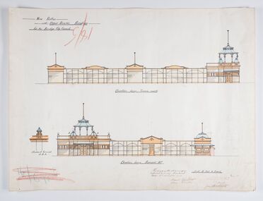
Work on paper - Architectural Drawing, City of Bendigo, New Baths at Upper Reserve Bendigo for the Bendigo City Council, 18th November 1912
The 'New' City of Bendigo baths also known as 'The Baths' were opened on 26th February,1913 at a cost of £2000. These baths made use of an existing dam and had men only and ladies bathing areas as well as a 'paddling paddock' for young children. This set of plans is for the Men's Bathing shed which serviced the men's bathing area adjacent to the still existing tennis courts on Barnard Street. In 1958 the Municipal Baths were replaced by an Olympic Pool and £17,000 was raised by public subscription towards this pool’s construction. Ink, pen, pencil and watercolour architectural drawing for the proposed new baths at the Upper Reserve on Barnard Street, Bendigo.New baths / at Upper Reserve Bendigo / for the Bendigo City Council / Elevation facing tennis courts / Elevation of Terminals at A, A, / Elevation facing Barnard Street / This is one of the drawings /referred to in my contract/ dated 18th November 1912 / Signed Robert J Rogers / (unknown) / Mayor Jas Semmensbendigo swimming club, rosalind park, upper reserve bendigo, faith leech memorial swimming pool, bendigo baths, city of greater bendigo community groups -
 City of Moorabbin Historical Society (Operating the Box Cottage Museum)
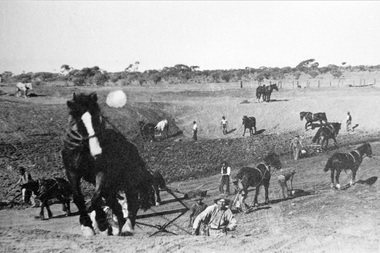
Photograph, Black & White Horse drawn scoops earthwork in Moorabbin Shire c1900, c1900
The, horse drawn metal scoop ,guided by a man, was used to clear earth for road making. Well before the introduction of motorised, mechanical graders and trucks the painstaking, labour-intensive work was undertaken by large teams of sturdy men using strong horses such as the draught horse. Roads were needed by the market gardeners to transport their produce to market. Later as the heavy wagon loads continually caused ruts and general degradation of the roadways a Plateway system was installed so that the wagon wheels could roll along the rails thus protecting the roadways. August 31st 2021 Ron Nash, from WA, informs us "The men and horses pulling earth scoops in the photo are not moving earth for road making - they are excavating an "earth tank", or dam, as described in common nomenclature today. This skill was known as "tank sinking", and tank sinkers were active in many rural and remote areas in the 1800's and early 1900's, establishing sizeable dams for important water reserves for community and farm and railway use. With the advent of mechanised equipment such as bulldozers, the trade of tank sinking was still carried out, but on a faster basis. I am a former tank sinker and earth moving contractor, now long retired." Early settlers in Moorabbin Shire had to build the roads, plateways, drains, as the settlement of the land, in Dendy's Special Survey 1841 Brighton, spread and market gardeners need to transport their produce to market. Their most valuable possession was the draught horse that was used for ploughing, drawing carts and these scoops.Black & White photograph showing many horses pulling metal scoops guided by men to move earth for road making in Moorabbin Shire c 1900Back Handwritten Informationplateway, roadworks moorabbin shire, draught horses, metal scoops, paviers, box alonzo, smith j l; chaff cutter, horse drawn carts, toll gates brighton, motor cars 1900, steam engines, early settlers, bentleigh, mckinnon, parish of moorabbin, city of moorabbin, county of bourke, moorabbin roads board, shire of moorabbin, henry dendy's special survey 1841, were j.b.; bent thomas, o'shannassy john, king richard, charman stephen, highett william, ormond francis, maynard dennis, market gardeners, vineyards, orchards -
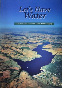 Wodonga & District Historical Society Inc
Book - Let's Have Water - A history of the Fish River Water Supply, Robin McLachlan, Denis Barrett, Jack Domis, Nick Welling, 1997
A history of the development of the management of the Fish River Water Supply Scheme in Central NSW. The scheme extends across the local government areas of the Shire of Oberon, the City of Lithgow and the City of the Blue Mountains.non-fictionA history of the development of the management of the Fish River Water Supply Scheme in Central NSW. The scheme extends across the local government areas of the Shire of Oberon, the City of Lithgow and the City of the Blue Mountains.water nsw, fish river region nsw, oberon dam, water resources development nsw australia -
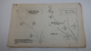 Kiewa Valley Historical Society
Mills Collection of Papers, 1. Unknown 2. October 1964. 3. Unknown SECV. 4. June 1963. 5. Unknown, Victorian Dept of Education. 6. Unknown SECV
Catelogue of flora and fauna of the 1960s in the Kiewa Region.A collection of papers including: 1. Three poems. 2. The ''Three Floras of Bogong'Oct 1964. 3. 'SEC Bird Life within and adjacent to the Kiewa Works area' recorded between 1963 and 1964. 4. 'General Geology of the Kiewa Area' June 1963. 5. Victorian Department of Agriculture, 'Tobacco', Notes for Students/Geology/Maize Culture/The Buffalo Dam Project/Stamped with 'Hoys Passenger Service Pty Ltd'. 6, SEC Kiewa Region, Forestry and Conservation.No. 5. - Stamped with 'Hoys Passenger Service Pty Ltd'flora, bogong, birds, geology, kiewa valley, tobacco, forestry and conservation, secv -
 Kiewa Valley Historical Society
Manila Folder - Newspaper cuttings and photos - Ryder Family, Ada & Walter Ryder Family
The Ryder family have lived and farmed in the Kiewa Valley since the 1840sMemorabilia of the Ryder family in the Kiewa Valley is an example of changing activities and interests etc in the Kiewa Valley since the 1840s through to the current day.1. Merit Certificate for Dorothy Ryder 1938 2. Three newspaper cuttings a) Hospital Town Highlight b) Time Moves On c) Joan Lang - the woman who could...and did! 3. Three slides a) Dairy Farm on banks of Kiewa River b) Mt Beauty c) Rocky Valley Dam 4. Four photos a) Beatrice Ryder on Empire Day b) Ada with son Walter Ryder c) Beatrice & Vera Ryder d)Skiers on High Plainsb) and c) photos labelled on the backryder family, kiewa valley farming -
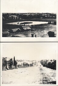 Bendigo Historical Society Inc.
Photograph - WES HARRY COLLECTION: BENDIGO ASYLUM AND LOWER DAM, (a)1876, (b) 1872
(a) Photograph taken from the Camp Hill State School Tower, looking north across the lower dam of Rosalind Park to the Bendigo Asylum ( Ann Caudle Centre) in the background, Photograph also shows the house where Wes Harry was born (27/02/1902). (b) Photograph of Mitchell Street Sandhurst, taken from about Mollison Street and with the Masonic Hall in the background. Two of the businesses pictured are C.H. Hoffmeyer on the left hand side and John Patterson's Drapery on the right.(a) C. Nobleton, (b) N. J. Caireplace, streetscape, mitchell street, bendigo, camp hill, lower dam, bendigo asylum, wes harry, mitchell street , c. h. hoffmeyer, john patterson, c. nobleton, n. j. caire