Showing 55225 items
matching documents-maps
-
 Greensborough Historical Society
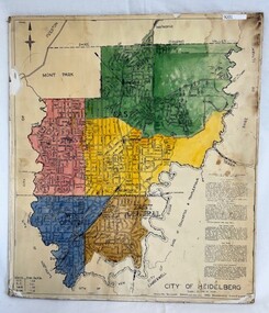
Poster - Map, City of Heidelberg, 1965c
Map of the City of Heidelberg sowing municipal boundaries and Wards are coloured. Scale 20 chains to 1 inch.An example of hard copy plans from the 1960s. Mainly from the Shire of Diamond Valley era (1964-1994).Colour map, pasted on card and laminated.Stamped and handwritten Council permissions, dates and other details. city of heidelberg -
 Clunes Museum
Document - FOLDER
FOLDER OF OLD SHIRE MAPS AND DOCUMENTS TALBOT AND CLUNES SHIRE, ETC, ETC.local history, folder, shire of talbot and clunes -
Tatura Irrigation & Wartime Camps Museum
Buttons
Issued to Sister Kathleen Heaphy of Australian Army Nursing service. Sister Heaphy was attached, for part of her service, to 28 Camp Hospital Internment camp 1.4 round identical brass buttons with a metal shank crown and map of Australia and wording around the circumference. 2 of the buttons have split pins through the shank.Australian Military Forces and a crown and map of Australia. Stokes and Sons Melbourneaustralian army nursing service, sister kathleen heaphy, 28 camp hospital internment camp 1, brass buttons -
 Tatura Irrigation & Wartime Camps Museum
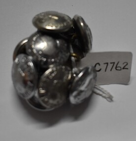
Buttons, 1049's
Issued to Sister Kathleen Heaphy of Australian Army Nursing service. Sister Heaphy was attached, for part of her service, to 28 Camp Hospital Internment camp 1.10 identical round silver metal buttons with a metal shank crown and map of Australia and wording around the circumference. 2 have split pins through the shank.Australian Military Forces and a crown and map of Australia. Stokes and Sons Melbourneaustralian army nursing service, 28 camp hospital internment camp 1, silver metal buttons -
 Marysville & District Historical Society
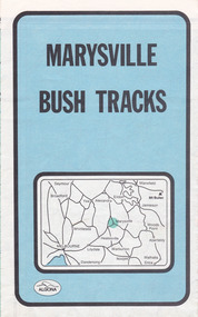
Map (Item) - Bush tracks map, John Siseman et al, MARYSVILLE BUSH TRACKS, 1987
A fold out map of the bush tracks in and around Marysville with information regarding each track. This map was published by Pindari Publications and distributed by Algona Publications. The track notes were compiled by John Siseman in 1987. The map was drawn by Glenn van der Knijff.A fold out map of the bush tracks in and around Marysville with information regarding each track.marysville, victoria, australia, map, bush tracks, pindari publications, algona publications, john siseman, gleen van der knijff, lady talbot forest drive, beauty spot walk, michaeldene track, steavenson falls, tree fern gully walk, trestle track, phantom falls, marysville town walk, marysville lookouts round walk, keppel falls, the beeches round walk, cumberland scenic reserve, cambarville, lake mountain, lake mountain walking track -
 Bendigo Military Museum
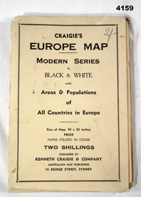
Map - MAP of EUROPE, Craigie"s Europe Map, 1939
... Maps ...The map features the areas and populations of all European countries as per 1939. Part of the collection re Frederick Gardner Davey DFC No 410533 RAAF. Refer Cat No 3536P for his service details.Folded map in black and white. Coloured British and German flags are pinned to countries on the map.On the front cover in pencil, “2/-“. (2 schillings)maps, europe -
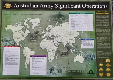 Lara RSL Sub Branch
Map - Areas in Which Australian Soldiers Have Served - World War 1 and World War 2 and Other Theatres (2 Off), Australian Army Significant Operations Map. (2 Off)
This map shows the areas in which Australian soldiers have served.Map of World showing Australian Armed Forces Theatre of Operations (Map)Rectangular in shape with a glossy front. (2 Off)Australian Army Significant Operationsaustralian army significant operations -
 Vision Australia
Photograph - Image, Ron Bruce reading Sydney Train map, 1971?
... Maps ...Ron Bruce reading a Braille map of Sydney's railway network.B/W photograph of man reading braille map1/71016 M&O -historicalroyal blind society of nsw, ron bruce, maps -
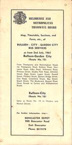 Melbourne Tram Museum
Map - Map, Timetable, Sections, and Fares, etc., of BULLEEN - CITY - GARDEN CITY BUS SERVICES
Map of the MMTB Bulleen - City - Garden City bus routes. Map, timetable & fares for Bulleen to City bus routemmtb, buses, doncaster, city -
![Map, Plan showing proposed deviation of the road through McKenzie's Flat to Bacchus Marsh. [Undated]](/media/collectors/5e461d8021ea67224c82f2a1/items/677d22f37f2053f3e5d500dc/item-media/677d25247f2053f3e5d50950/item-fit-380x285.jpg) Bacchus Marsh & District Historical Society
Bacchus Marsh & District Historical SocietyMap, Plan showing proposed deviation of the road through McKenzie's Flat to Bacchus Marsh. [Undated]
The date of this map or plan is uncertain. McKenzie's Flat is a bushland picnic area on the Lerderderg River in the Lerderderg State Park close to Bacchus Marsh. The proposed road deviation shown on this map is very close to a sharp bend in the Lerderderg River which shows an island in the centre of that bend. The name of a landholder, J.B. Perry is shown on the map close to the area of the road deviation.The land shown is identified as within the Parish of Merrimu.Single page map showing a proposed deviation of the road from McKenzie's Flat to Bacchus Marsh. Scale: 5 chains to 1 inch. Part of a set of maps which are pasted into a bound volume containing 76 maps or plans in total. High resolution digital image stored on BMDHS computer network. mckenzies flat bacchus marsh, bacchus marsh roads and streets -
 Melbourne Tram Museum
Legal record, Melbourne & Metropolitan Tramways Board (MMTB), "Agreement Melbourne and Metropolitan Tramways Board with A.N. Colquhoun", May. 1948
Bound Document, two large ruled grey folded sheets with containing various schedules and letters typed onto foolscap (folio) or quarto sheets. Titled "Agreement Melbourne and Metropolitan Tramways Board with A.N. Colquhoun "signed and sealed on 18th May 1945. Bound on left hand side with green ribbon. Gave Archibald Norman Colquhoun the right to advertising on the inside of tramcars and buses and on the rear of tickets for five years. Gave details of the contract, minimum payments, rebates and conditions of the contract. Schedule A - two pages - space available in tramcars Schedule B - two pages - buses ditto Schedule C - passenger check tickets / annum - some 350million - one page Schedule D - actual tendered document, 15/4/1948 - one page Schedule E - the Specification for the tender - five pages Schedule F - Letter signed by A.N. Colquhoun, on The Reilly Advertising Co. letterhead of which has was the Managing Director giving his credentials. Schedule G - supporting letter on The Reilly Advertising Co letterhead. Schedule H - Letter from the Commercial Bank of Australia Ltd - supporting Mr A.N. Colquhoun. Schedule I - letter from MMTB advising A.N. Colquhoun of his successful bid. Schedule J - Draft agreement in tender document - five pages - signed 15/4/1948."996/7" in top left hand corner of document and stamped "Treasurer"trams, tramways, tickets, advertisements, tramcars, buses, contracts, legal agreements -
 Kiewa Valley Historical Society
Maps - Educational x 10 and Kiewa Scheme x1
... Maps ...Maps were used to teach children geography, the explorers, the minerals, the world etc. The school bought and stored the maps so that they were available for use. This predated electronic devices. The KHE Works map was hand drawn showing lots of detail.These maps were used by the Bogong Primary School. The Kiewa Hydro Electric Works was built by the SECV and produced hydro power. This map may have been used by pupils as well as workers on the Works. Large coloured maps on canvas, with a wooden beam along the top and bottom. Each one has a cord attached to the top so that the map may be hung up on a wall. Some are made by Chas. H. Scally & Co., Baronia Ave., Wollstonecraft, N.S.W. The Kiewa Hydro Electric Works map is pinkish and shows Rocky Valley Dam, Lake Guy and Mt Beauty pondage in dark blue.maps, educational maps, geography, primary school, kiewa hydro electric works -
 Greensborough Historical Society
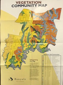
Maps, Vegetation Community Map, 2000c
... Maps ...Map and table of indigenous vegetation 'communities' in Banyule. Map & table, printed in colour both sides, folded to A4banyule city council, flora, vegetation, gum trees -
 Greensborough Historical Society
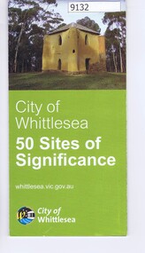
Pamphlet - Map, City of Whittlesea, City of Whittlesea, 50 Sites of Significance
Pamphlet of historical places in Whittlesea with map and imagesColour pamphlet with text, fold out map and coloured imageswhittlesea, historic sites whittlesea -
 Greensborough Historical Society
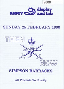
Booklet, Simpson Barracks, Then and now: Army display and fair 1990, 25/02/1990
Display and fair programme describing events with map of locations, held at Simpson Army Barracks 25/02/1990.8 page booklet with programme and map.Paperaustralian army, watsonia army barracks, simpson army barracks -
 City of Kingston
Pamphlet - Colour, Arthur Tuckett & Son, Auctioneers and Subdivisional Specialists, Auction of Station Estate, Moorabbin, 1923
Sales plan for land in the suburb of Moorabbin, bounded by Railway Crescent, South Road, Jasper Road and Pattersons Road.The developing urban area of Moorabbin within the City of Kingston. This land sale pamphlet illustrates the subdivision of land within the municipality and the changing demographic of the district as new houses are constructed.Colour pamphlet advertising an auction of the Station Estate Moorabbin. Incorporates details of the shopping facilities, proximity to the railway line, variety of schools and churches in the area, and a sales plan for home sites and shop fronts. Incorporates a map of the estate bordered by Pattersons Road, Japer Road, South Road and Railway Crescent. Handwritten in grey pencil top right front page: Station Estate / late [indecipherable] Handwritten in red pencil on subdivision map: x [on majority of properties marked on the map] Handwritten in grey pencil on subdivision map: additional subdivisions drawn in and large lines drawn across the mapmoorabbin, land sales, estate -
 Peterborough History Group
Map - Map of the town, Government Printer, Township of Peterborough
... maps ...Map donated by Barry Jenkins and assume that updated names were written on the map by him. Good information pertaining to the history of each allotment. Significant as it shows the names of the owners of each allotment in 1931 and handwritten notes of more recent owners.27/6/1931 paper map of the township of Peterborough including names of the landowners at that time.Handwritten landowner names over the original printed names.peterborough, old maps, maps -
Port Melbourne Historical & Preservation Society
Photograph - Woolsheds between Beacon and Barak Roads, Port Melbourne, Don Hossack, 1947
Donated by Don Hossack who took the photograph when he was 16 years old and working at the woolsheds. He recalls that bags of oats and barley were stored here.Photo (10 x 12" glossy black and white print) of the wool sheds between Beacon and Barak Roads. Shows north easternmost sheds and rail line. The wool sheds were built by the Americans during World War II and taken down again in the 1950s . Map (hand drawn) on rear shows location of photograph.map (hand drawn) of location of photographtransport - railways, built environment - industrial, war - world war ii -
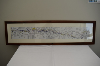 Dandenong/Cranbourne RSL Sub Branch
Map - Burma - Siam Railway
Is of Historical significance. This map was put together by T.R.Beaton on the 15th February 2002. He used old railway and road maps to show the route and it took him over 15 months to put together. T.R. Beaton was Manager/Curator of Australian Government Memorial Museum built above " Hellfire Pass " or Konyu Cutting.Framed picture map of the Burma _ Siam Railway. -
 Greensborough Historical Society
Map, Greensborough c 1980s, 1980s
Map of Greensborough and surrounds showing bus routes servicing Eltham College.Map of Greensborough and surrounds, black print with colour markings."Bundoora Retirement Village" marked in red pen at E20greensborough - maps, eltham college, bus routes, public transport -
 Bacchus Marsh & District Historical Society
Map, Bullengarook Parish, County of Bourke
An undated parish plan map for the parish of Bullegarook. This parish area is close to the Bacchus Marsh district and borders some of the areas contained within the former Bacchus Marsh Shire and present day Moorabool Shire.A single page paper map showing the parish plan map for Bullengarook. This parish area contains the locality of Bullengarook and parts of the Wombat State Forest and is close to the town of Gisborne. A cadastral map showing land ownership. The map is not dated but a very similar map held by the State Library of Victoria is estimated to date from about 1927. The map is pasted into a bound volume containing 76 maps or plans in total. High resolution digital image stored on BMDHS computer network. bullengarook parish maps -
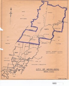 Greensborough Historical Society
Map, City of Heidelberg, City of Heidelberg, 1962, 02/02/1962
Map of City of Heidelberg showing boundaries of its six wards; North Ward is highlighted, covering Watsonia, Greensborough, part Bundoora, St Helena, Plenty, Yarrambat and Diamond Creek.Blue print mapCity of Heidelberg Scale: 1" to 1 ml. G.M.H. 2.2.62city of heidelberg, heidelberg - maps -
Clunes Museum
Map
... maps ...MAP DATED JULY 21ST,1873MAP OF CLUNES WATER SUPPLY, TOWNSHIP OF CLUNES, SHOWING SYSTEM OF DISTRIBUTION.TOWNSHIP OF CLUNESlocal history, document, maps, clunes water -
Whitehorse Historical Society Inc.
Pamphlet, Schwerkolt Cottage Mitcham
A pamphlet issued by City of NunawadingA pamphlet issued by City of Nunawading on Schwerkolt Cottage with photographs and location map.A pamphlet issued by City of Nunawading schwerkolt cottage, city of nunawading -
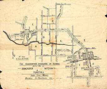 Whitehorse Historical Society Inc.
Map - Fire Underwriter's Association Sketch Map, Fire Underwriter's Association of Victoria, Doncaster, Mitcham and Tunstall, 29/4/1932
Shetch map of Doncaster, Mitcham and Tunstall. Scale 1inch = 40 chainsA sketch map of Doncaster, Mitcham and Tunstall by the Fire Underwriters' Association of Victoria.non-fictionShetch map of Doncaster, Mitcham and Tunstall. Scale 1inch = 40 chainsmap, doncaster, mitcham, tunstall -
Creswick Campus Historical Collection - University of Melbourne
Document - Photocopies of John La Gerche letterbooks and Ron Hateley's 2007 book drafts
Research documents related to La Gerche collected by Ron Hately . Some duplication of catalogue item 1200 in two ring binders and one orange folder (one blue, one black). Several loose documents and 11 CDS.Documents -
Hume City Civic Collection
Map, Sunbury Township 1857
This is a reprint of a 1857 map of the township of Sunbury in the County of Bourke produced by the Public Records Office by courtesy of the Surveyor General in 1978.This is a reprint of a 1857 map of the township of Sunbury.sunbury, shire of bulla, sunbury township, 1850s -
Creswick Campus Historical Collection - University of Melbourne
Document
Documents relating to the Nepal - Australia Forestry Project ResourcesDocuments -
Creswick Campus Historical Collection - University of Melbourne
Ephemera
Box of various unsorted documents and display materials FCVDocuments