Showing 3566 items matching "environments"
-
 Kiewa Valley Historical Society
Relay Protection Instrument, Circa 1950's
This protection relay apparatus (a large electrical fuse), which permits the easy monitoring and disconnection of faulty electrical apparatus connected to the large SEC Victoria Hydro Scheme's electrical power producing generators. These generators are powered by the hydro force of "stored" water at a higher altitude. The establishment of both the NSW and Victorian Hydro Schemes was achieved from the early 1900's to the 1960's. At this point in time the need for additional power sources to quench both an industrial and domestic demand for electricity was purely an economic and not and environmental (carbon reduction) factor. This hydro scheme was instigated by "the Government of the day" as a bold move and was the major force of the World War II refugee and "technical" workforce inclusion of skilled and unskilled migration into the Australian environment. Although this mass "invasion" of workers with families was thought of in some circles as intrusive, the expansion of population post war years and its integration into the Australian rural sector, produced the multi- lingual multi-cultural diversity of later years.This protection relay is very significant to the Kiewa Valley as its use was introduced during the Kiewa Hydro Scheme. Although only a small apparatus it was part of the explosion of human resources into the valley. This influx of population transformed the region from that of a basically quiet rural region to one which evolved into both an industrial and a larger residential community. This evolution in the valley created a change, not only in the "physical" landscape but also the socio-economic expansion which permitted other "tourist" based industries into the valley.This protection relay unit has a black painted metal shell with four copper enclosed "prongs" fastened to the rear of the housing(from a bake-lite plate) . Between these "prongs" are four "empty" points allowing additional "screw on" bases. The front glass enclosed meter and recorder allows for the identification and automatic disconnection of any faulty equipment connected to the main power generator. This equipment acts similarly to a modern day circuit breaker found on the electrical circuit boards of residential homes.On the top section of the front panel "ASEA" to the left "Made in Sweden" and to the right "Frabrique en Suede" below this "RIS" below this a graph and next to it two columns of numbers and a pointer for each setkiewa hydro electricity scheme, victorian state electricity commission, relays, generators -
 Kiewa Valley Historical Society
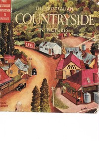
Book - Reference Countryside, The Australian Countryside in Pictures, circa 1950s
This book is a "snapshot" in time (1950s) detailing life in Australia covering a time when a "man's word and handshake" were his moral and quasi legal bond, and the now relative defunct saying "smoko" (having a "time out" from work for a cigarette and tea or coffee). The book spans an era where the male was still the "head" of the family even though for a majority of families the women took on the many "male only" roles during the World War II period. This shift in the leadership of the family hierarchy is mentioned, so ever slightly, (not to offend the still predominant macho male image) in both rural and city environments. The effects of the war, and later the push for women's emancipation and equality in both family, social, workplace and political areas of life, since this book was published, is now finally resolved. However there are still some sections of the recent migrate population where this male dominance is causing a few problems.The significance of this book is not only because it was donated by Mrs C. Roper ( from the Roper Family, a pioneer Kiewa Valley and surrounding Region family - originally beef cattle graziers) but also a Kiewa Valley resident and family, experiencing the shift in the social and economical life of post World War II rural Australia. The strong heritage link to this region of many families still residing within its boundaries, is a clear affirmation of the bond that the Kiewa Valley and its Regions have upon family unity. This unity within the rural environment is something that is attracting more and more families from sometimes alienating city life.This printed coloured sketched, or painted paper sleeve of the book is freely wrapped over a dark red hard cover. Into the front of the cover is pressed a standing pose of a farmer with long sleeves rolled up over his elbows. Behind him and to the right are what appears to be three sacks of wheat and next to him is a merino sheep. To the left and down are two dogs one with a fox in its jaws. The book contains 240 pages, 300 illustrations in gravure and 25 pictures in full colour. The inside fly leaf is a colour photograph of a rural scene with dirt road running in the centre and to the left a farm house and a five bay open storage barnOn the tittle page is a signature "C Roper"country life, australian "outback", rural industries, life on the land, swag-man of the bush -
 Kiewa Valley Historical Society
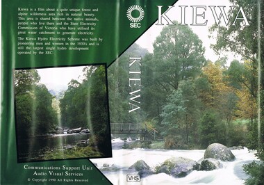
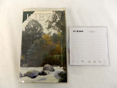
VHS Tape - Kiewa Hydro Electricity Scheme x2, Kiewa, Circa 1990
This VHS was produced by the State Electricity Commission of Victoria, to show the pristine state of the Kiewa River and Valley post the completion of the Kiewa Hydro Electricity Scheme (Circa 1950s), The late 1970s on wards was the beginning of deeper social scrutineering by pro environmental groups such as the Australian Wilderness Society (1976) and the Greens (political Party), before, during and after the construction phases of any man made structures in forest/bush areas which may or could damage or adversely affect the natural flora and fauna of sites. This promotional VHS, which was produced in the 1990s, was to project that unlike the Tasmanian State Electricity Commission (Franklin Dam issue), the Victorian State Electricity Commission acted in a way to protect the environment to the maximum level possible. With the passage of time since, and the issue of the global push to minimise carbon pollution, and as an alternative to coal fired power stations, the use of hydro electricity can now be seen as a highly efficient alternative to "coal powered" electricity. This VHS is a snap shot in time (1990) when the Kiewa Valley was still relatively under populated and holiday houses owned by city bound workers was still relatively insignificant. As more and more holiday makers retire to a small but friendly region(Kiewa Valley and Mount Beauty) the increase in visitor numbers will affect the local rural bush scene more and more. The changes that will occur (in time) can be measured against the scenes presented in this video. The additional resources provided by the State Electricity Commission of Victoria of "alpine bush" fire control and management, together with an ongoing educational scheme for school children in learning about what constitutes the Alpine country's unique environment, are a very important offshoot, benefitting to both the communities within the Kiewa Valley and regional Victoria.This VHS tape is stored within its own plastic cover which has a front side covered by a coloured photograph(both front and back cover) of the Kiewa River, just to the north east of the Mount Beauty township. The VHS tape is nestled within a formed inner structure which not only prevents the tape from moving to and fro but also unnecessary intrusion of foreign particles.Front cover "KIEWA" on the spine top circle with lines projecting out and below this "SEC". Middle of spine "KIEWA" and bottom of spine "VHS"secv, kiewa valley, dale-bromley, cy-duff, chris- harding, michael-glucz, forestation education, wilderness photography, nature film. -
 Royal Australian and New Zealand College of Obstetricians & Gynaecologists (RANZCOG)
Infant feeding bottle, 'Agee Pyrex Feeder', Crown Crystal Glass, c. 1961-63
Small feeding bottles were used to feed milk to newborns or juice to older infants. Crown Crystal Glass were an Australian glass manufacturer, who were the Australian vendors for Pyrex from 1926, importing from the UK. In 1961, Crown Crystal Glass began manufacturing their own Pyrex, under the name Agee Pyrex (until 1963), Crown Agee Pyrex (late 1960s), Crown Pyrex (1970s), Crown Ovenware (1970s) and Pyrex Ovenware (late 1970s until early 1980s). Source: That Retro Piece, 'PYREX | Australian', https://thatretropiece.com/collections/pyrex-australian "The use of pyrex bottles became more prevalent in Australia in the second half of the 20th century and baby’s bottles made of pyrex were popular as they were easily sterilised in the home environment." Source: Warrnambool and District Historical Society Inc., 'Bottle, The Perfect Agee Feeding Bottle, Mid 20th century', https://victoriancollections.net.au/items/592fe71ad0cdd520341b3954Small clear glass bottle with a short narrow neck. Imprinted with calibrations for ounces (0-4) and millilitres (0-120). Embossed on side of bottle: "Agee/ PYREX/ Feeder".infant feeding, infant care -
 Bayside Gallery - Bayside City Council Art & Heritage Collection
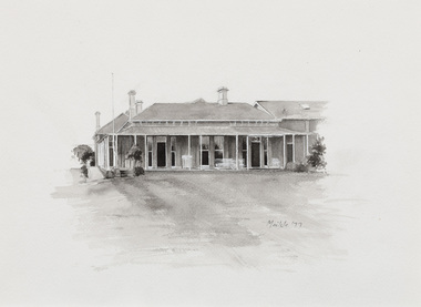
Work on paper - ink and watercolour, Annette Meikle, Band Rotunda, 1977
In 1977, artist Annette Meikle undertook a commission to illustrate a book recording stories of places and people in the Bayside area. It was published in 1978 as Sandringham Sketchbook, with text by Elizabeth Waters. The sketches were intended to record remaining examples of Bayside’s early architecture and environment, as well as reflect newer architectural changes. Meikle went on to donate 22 of these sketches to Bayside City Council in 2003. Built in 1926, the Band Rotunda was a gift to the people of Sandringham by local doctor and former soldier Thomas Garnet Leary. On Sunday afternoons throughout the inter-war years, brass bands such as the military uniformed 46th Battalion Brass Band and the popular Sandringham Boys Band would play. The canopied top storey comfortably held twenty five performers with enough room for their large instruments. Large crowds would picnic along the foreshore listening to the performances. The drinking fountain pictured under the rotunda has since been removed.Annette Meikle, Band Rotunda 1977, ink and watercolour, 33.8 x 23.5 cm. Bayside City Council Art and Heritage Collection. Donated by the artist, 2003annette meikle, sandringham sketchbook, elizabeth waters, band rotunda, sandringham, thomas garnet leary, foreshore -
 National Wool Museum
Taxidermy Sheep, Booka, c1980
The ‘Wanganella’ merino sheep stud was established by the Peppin brothers in the Riverina in 1861. The introduction of a single French ‘Rambouillet’ Merino ram, called Emperor, is now widely acknowledged as one of the most important events in the development of the Peppin stud. As many as 70% of today’s Australian Merinos are said to be directly descended from the Peppin-developed sheep. Its heavy fleece falls in the mid-range of Merino wool qualities (20 to 23 microns) and is protected from the excesses of the environment by a comparatively high content of natural wool grease, which can be seen in the creamy colour of Booka’s wool. Fred Peppin said [of the sheep breed] "We were satisfied with the type of wool that the country would grow, instead of endeavouring to produce what the climate and soil continually fight against. Thus we developed all its good natural tendencies and after that the flock had a character of its own.”Peppin merino stud. Has a large body and long legs. Two horns protruding from its skull.sheep, wanganella -
 Glenelg Shire Council Cultural Collection
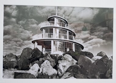
Photograph, John Wilkins, Photographer, Corkscrew, n.d
From the Port of Portland website: The original corkscrew was built as a gift to the Portland Harbour Trust by the contractors who constructed the port. It was designed in 1960 and fabricated shortly after the completion of the Main Breakwater. The corkscrew was built as an observatory, with the observation deck approximately 13 metres above sea level. Its original design life was less than 25 years. The original structure was dilapidated, extremely unsafe and in danger of collapse. Understanding the historical and community importance of the original structure, in 2016 Port of Portland began the process of designing and building a replacement. The new corkscrew is a similar size and has been based on the same spiral shape of the original structure. The corkscrew has been constructed using mild steel, heavily coated in marine grade paint (similar to what is used on ships). Heavy duty plastic has been used for the walkway section which will withstand the harsh elements of the marine environment.Photograph of the Portland Corkscrew in the 1980s. Image is in black and white. The corkscrew is in front of a sky which is dotted with fluffy clouds. To the front of the Corkscrew are large rocks. The building is a spiral with glass windows. There is a white metal fence around it and a white pole at the top which reaches to the top of the image.Bottom right: J WILKINSportland, seafront, maritime, portland landmark, corkscrew, port of portland, portland photography, photography -
 The Beechworth Burke Museum
Geological specimen - Ventifact (wind- or ice-shaped) pebble
Ventifacts are sand-blasted rocks that are typically faceted and often display parallel grooves carved by wind-blown sand. They are useful indicators of wind direction and strength in environments such as deserts, mountains, and coastal areas because they are usually not hidden by later sediment, soil or vegetation cover. In Antarctica ventifaction is strongly related to the composition or type of rock. Ventifacts are important because they provide evidence for abraders such as sand, dust or snow and ice crystals, and offer a unique understanding of past wind processes that are effective in the reconstruction of past wind flow conditions and can provides clues to weather and climate changes in the past. Interestingly ventifacts have also been found on the surface of Mars. They were a threat to the NASA rover due to the sharp angles of the facets, created by the Martian wind over the course of millions of years. These Martian ventifacts act like weathervanes for past wind and weather patterns on the red planet in a similar manner to those found on earth.The Geological Survey of Victoria was instigated in response to the Victorian Gold Rush which began around 1851 in the Beechworth, Castlemaine, Daylesford, Bendigo and Ballarat areas. The survey was conducted by Alfred Richard Cecil Selwyn from his arrival in December 1852 until his resignation in 1869and during this time he trained many notable geologists, e.g. Aplin, Wilkinson, Daintree, who went on to other State survey senior positions. This specimen was among those donated to the Burke Museum in 1868.A hand-sized solid mineral specimen in shades of dark and light browns with light lines visible in all configurations and a groove on configuration 2.light lines visible in all configurations and a groove on configuration 2burke museum, beechworth, geological, geological specimen, ventifact, antarctic region, antarctic, alfred richard cecil selwyn, alfred selwyn, wind direction, wind strength, abraders, wind flow, climate change, reconstruction of wind flow conditions, weather change, mars -
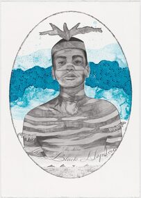 Merri-bek City Council
Lithograph, Megan Cope, Black Napoleon (Eulope), 2019
Working across installation, video and painting, Quandamooka artist Megan Cope investigates issues relating to colonial histories, the environment and mapping practices. Black Napoleon (Eulope) is part of a series of lithographs that highlights what Cope sees as ‘just one of the many stories of powerful and clever people defying Empire’ at the turn of the 19th century in Australia. The Black Napoleon series was produced as part of the Australian Print Workshop’s French Connections project. The project aimed to produce new work responding to the National Archive in Paris, with a focus on cultural materials relating to early exploration of Australia and the Pacific. It was important to Cope that she did not simply repeat the material of the archive, which was collected and conserved within a colonial framework. Instead, Cope’s work addresses Eulope’s sovereignty and role in resisting invasion. Eulope was a Quandamooka man named after Napoleon Buonaparte because of his leadership in battles against British forces, which invaded Stradbroke Island in the early 1800s. -
 Wooragee Landcare Group
Photograph, 20 June 2004
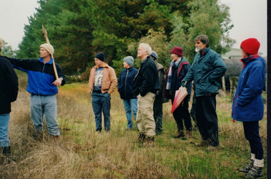
Photo shows, (L-R): Luke Bayley; Ray Henderson; Chris Robinson; Ann Henderson; Lesley Finedon, assessing successful stream side rehabilitation at Bev DeJong and Bob Dunnett's place during a paddock demonstration and tree planting field day, called 'Really Successful Tree Planting!' run by Wooragee Landcare on Sunday 20th June 2004. Maintaining and reforesting native trees, shrubs and grasses are really important for a variety of reasons, including creating native habitat and food for birds and other animals, shade, biodiversity, visual appeal, cooling, shade for urban areas, sequestering carbon and conservation among other considerations. The planting must be consistent with the particular needs of the environment, such as trees or shrubs which would naturally occur and are native to the area. Tree planting demonstrations such as this one run by the Landcare Group ensures that the projects are being managed consistently with an overarching commitment to land protection and management and the best methods for best outcomes are employed.This photograph is significant as it provides evidence of a project undertaken by the Wooragee Landcare Group to educate themselves and members of the public on successful techniques needed to plant and maintain trees for replanting in the Wooragee area. The Wooragee Landcare Group has been instrumental in the co-ordination of programs relating to biodiversity protection in the local area, providing great assistance to landholders.Landscape coloured photograph printed on gloss paper.Reverse: WAN NA 0ANA2N0 NNN-1 1636/ [PRINTED] (No.23)/936/wooragee landcare, wooragee landcare group, beechworth, landcare group, wooragee, tree planting, successful tree planting, demonstration, paddock demonstration, tree planting field day, really successful tree planting, land protection and management, land management, native trees, conservation -
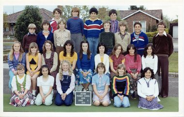 Broadmeadows Historical Society & Museum
Photograph - Class Photograph, Jacana Primary School: Grade 6, 1979, 1979
This 1979 group photograph of Grade 6 students and their teacher at Jacana Primary School offers a valuable window into the everyday rhythms of school life in Melbourne’s northern suburbs during a time of notable social and urban transformation. Established in 1959, Jacana Primary served as a key educational and social institution until its closure in the early 2000s. Beyond its academic role, the school fostered a strong sense of place, belonging, and shared experience among its students and staff. The image reflects Jacana Primary’s commitment to creating inclusive and supportive learning environments. It also subtly documents the growing cultural diversity of the Jacana area in the late 20th century, as suburban development brought together families from a range of backgrounds. As part of the school’s visual archive, this photograph contributes to a broader understanding of how public schools helped shape community identity, promote social cohesion, and influence the lives of generations of children and families.This 1979 group photograph of Grade 6 students and their teacher at Jacana Primary School is a historically significant artifact that documents the educational and social landscape of Melbourne’s northern suburbs during a period of rapid urban and demographic change. As a visual record of a public school community, the image reflects the values, diversity, and everyday experiences of students and educators in the late 20th century. Jacana Primary School, established in 1959 and closed in the early 2000s, played a foundational role in shaping the identity and cohesion of the Jacana community. The photograph captures not only the individuals present but also the inclusive and supportive environment that the school fostered. It offers insight into the evolving cultural fabric of the suburb, as families from varied backgrounds came together through shared educational experiences. The image is significant for its contribution to understanding how public schools functioned as social anchors—promoting belonging, continuity, and collective memory. It serves as a testament to the enduring impact of local education on community development and the lives of generations of children and families.Colour Photograph on Matte Paper, with white borderBack: Top Left Corner: (White label): PH-5012/ (Blue Label): PH-5599, Centre (in pencil) J.P.S., Manufacturers Mark; this paper/Manufactured/ by kodakjacana primary school, education, photograph, group photograph, 1979, class photograph, grade 6 -
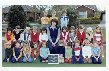 Broadmeadows Historical Society & Museum
Photograph - Class Photograph, Jacana Primary School: Grade Prep, 1979, 1979
This 1979 group photograph of Grade Prep students and their teacher at Jacana Primary School provides a meaningful glimpse into the rhythms of early school life in Melbourne’s northern suburbs during a period of significant social and urban change. Founded in 1959, Jacana Primary served as a foundational institution for the local community until its closure in the early 2000s, offering more than education—it fostered a sense of place, belonging, and shared experience. The image reflects the school’s commitment to nurturing inclusive and supportive environments for young learners. It also highlights the cultural diversity emerging in Jacana during the late 20th century, a time when suburban expansion brought together families from varied backgrounds. As part of the school’s visual archive, this photograph contributes to a broader understanding of how public schools shaped community identity, supported social cohesion, and played a vital role in the lives of generations of children and families. This 1979 group photograph of Grade Prep students and their teacher at Jacana Primary School is a historically significant record of early childhood education in Melbourne’s northern suburbs during a period of suburban expansion and social change. Established in 1959, Jacana Primary played a central role in the community for over four decades, providing not only foundational learning but also a space for connection, inclusion, and shared identity. The image captures the essence of the school’s values—belonging, diversity, and friendship—while offering insight into the demographic and cultural landscape of Jacana in the late 20th century. As part of the school’s visual archive, it contributes to a broader understanding of how public education shaped local identity and fostered enduring community bonds across generations. The photograph stands as a testament to the legacy of Jacana Primary and its impact on the lives of students, families, and educators.Colour Photograph on Matte Paper, with white borderBack; Top Left Corner: (White label): PH-5007/ (Blue Label): PH-5594, Centre (in pencil) J.P.S., Manufacturers Mark; this paper/Manufactured/ by kodakjacana primary school, education, photograph, group photograph, grade prep, 1979, class photograph -
 Broadmeadows Historical Society & Museum
Photograph - Class Photograph, Jacana Primary School: Grade 5/6P, 1991, 1991
This 1991 group photograph of Grade 5/6 students and their teacher at Jacana Primary School provides a vivid snapshot of suburban school life in Melbourne during a time of notable social and urban transformation. Established in 1959, Jacana Primary served as a vital educational and community hub until its closure in the early 2000s. More than a place of learning, the school fostered a strong sense of identity, belonging, and shared experience among its students and staff. The image reflects the school’s commitment to nurturing inclusive and supportive environments for young learners. It also subtly documents the growing cultural diversity of Jacana in the late 20th century, as suburban development brought together families from a wide range of backgrounds. As part of the school’s visual archive, this photograph contributes to a broader understanding of how public education helped shape community identity, promote social cohesion, and influence the lives of generations of children and families.This 1991 class photograph of Grade 5/6 students and their teacher at Jacana Primary School is a historically significant artifact that captures a moment in time within a vibrant and evolving suburban community. Taken during a period of considerable social and urban change in Melbourne’s northern suburbs, the image reflects the school’s enduring role as a centre of education, inclusion, and community connection. Jacana Primary School, established in 1959 and closed in the early 2000s, was more than an academic institution—it was a place where children from diverse backgrounds came together, forming lasting relationships and shared memories. The photograph documents the increasing cultural diversity of the Jacana area in the late 20th century, offering insight into how public schools adapted to and reflected broader societal shifts. As part of the school’s visual archive, this image contributes to the historical narrative of public education in Victoria. It highlights the importance of schools as social anchors, fostering identity, cohesion, and continuity across generations. Its preservation ensures that the legacy of Jacana Primary School—and the community it served—remains visible and valued. Colour Photograph on Satin PaperBack: Top Left Corner: (Blue Label): PH-5500, Centre (in pencil) jacana primary school, education, photograph, group photograph, class photograph, andrew martins, karen marks, gunduz tabag, jayson sharman, jodi carroll, freda nguyen, houssein houssein, ross coats, andrew jenkins, debbie miller, tien huynh, lisa schewtschuk, alan stewart, salina leung, carrie lewis, brett chapman, peita anderson, danny borland, belinda norman, rebecca horton, mark layton, vicki bell, nahed elwohamed, shar-rena fitzgerald, mr. b. o'dea, mr. g. payne, grade 5/6p, 1991 -
 Federation University Art Collection
Painting - Acrylic on Linen, 'Tingari Cycle' by Walala Tjapaltjarri
Walala Tjapaltjarri (b. c1960) Language: Pintupi Region: Kiwirrkuru In late 1984 Walala Tjapaltjarri and several other members of the Pintupi Tribe walked out of the remote wilderness of the Gibson Desert in Western Australia and made contact for the first time with European society. Described as 'The Lost Tribe', he and his family created international headlines. Until that day in 1984, Walala and his family lived the traditional and nomadic life of a hunter-gatherer society. Their intimate knowledge of the land, its flora and fauna and waterholes allowed them to survive, as their ancestors had for thousands of years. It is this sacred landscape, and its significant sites, that Walala so strikingly describes in his paintings. His style is generally highlighted by a series of rectangles set against a monochrome background. He paints the Tingari Cycle (a series of sacred and secret mythological song cycles) which are associated with the artist's many dreaming sites - they are Wilkinkarra, Maruwa, Tarrku, Njami and Yarrawangu, to name a few. These Dreamings are the locations of significant rockholes, sandhills, sacred mountains and water soakages in the Gibson Desert. (http://www.kateowengallery.com/artists/Wal90/Walala-Tjapaltjarri.htm, accessed 18 May 2015) Walala Tjapaltjarri started painting in 1997. His earliest works were in a classical Tingari style usually reserved for body painting, ground painting and the decoration of traditional artifacts. Within a couple of months his painting had evolved into his own innovative style of work, including the abstraction of classical Pintupi designs which resulted in a highly graphic language to speak of his country and ceremonial sites. The rectangles so prominent in his paintings form both a physical and spiritual map establishing Walala as a discerning draughtsman for his ancient country. (http://www.kateowengallery.com/artists/Wal90/Walala-Tjapaltjarri.htm, accessed 18 May 2015) This item is part of the Federation University Art Collection. The Art Collection features over 1000 works and was listed as a 'Ballarat Treasure' in 2007.Tingari Cycle - During the Tjukurrpa (Creation Era) Tingari ancestors beings gathered at a series of sites for Malliera (Initiation) Ceremonies. They travelled vast stretches of the country, performing rituals at specific sites that in turn created the diverse natural features of the environment. The Tingari men were accompanied by novices and usually followed by Tingari Women. The creation stories and rituals are venerated in the song cycles and ceremonies of today, forming part of the teachings of the post initiatory youths, whilst also providing explanations for contemporary customs. Walala Tjapaltjarri uses a highly personalised and minimal style to represent aspects of the sacred Tingari Cycle, an epic journey of Ancestors of the TJukurrpa (Creation Era). He paints aspects of the Tingari Cycle which are associated with the artist's many sacred sites - such as Wilkinkarra, Maruwa, Tarrku, Njami and Yarrawangu, to name a few. These are locations of significant rockholes, sandhills, sacred mountains and water soakages in the Gibson Desert. (http://www.kateowengallery.com/artists/Wal90/Walala-Tjapaltjarri.htm, accessed 18 May 2015)art, artwork, walala tjapaltjarri, aboriginal, dreaming, creation era, acrylic on linen, pintupi, kiwirrkuru, tingari, wilkinkarra, tarrku, njami, yarrawangu -
 Eltham District Historical Society Inc
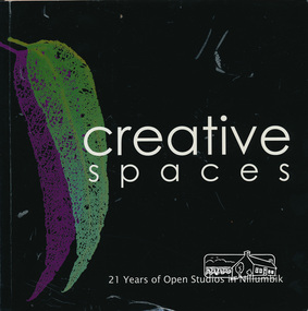
Book, Creative Spaces : 21 years of Open Studios in Nillumbik, 2008
Published for the Nillumbik Artists' Open Studio Program. Text edited by Tony Summers and Elizabeth Vercoe. All images by Tony Summers, Upfront Pictures unless otherwise credited. Contents: Nillumbik Artists' Open Studios, Nillumbik: an historic and artistic meander, Open Studio: a reflection, Open Studios: a historic reflection, the artists, the studios, Linda MacAulay, Chris and Mary-Lou Pittard, Linda De Toma, Peter Accadia, Wendy Hicks, Stephanie Mew, Piers Brown, Jane Annois, The Naughty See Monkey, Ona Henderson and Sydd Tunn, Robina and Tony Summers, Peter Oyston, Elizabeth Vercoe, Judy Racz, Veronia Holland, Shaaron Smith, Margaret Summerton, Kim Tarpey, Judy Trembath, Dena Ashbolt, The Bladessin Press, Rob Hayley. The Nillumbik Artists' Studios Program was created in the 1980s by the Shire of Eltham and continues to operate throughout the Shire of Nillumbik in 2018. The program offers the rare opportunity to visit studios and talk to artists about their work in their own working environment.Softcover bound book. Text with colour photographs. Includes profiles of artists from the Shire of Nillumbik. 95 pagesnillumbik artists' open studios, linda macaulay, chris pittard, mary-lou pittard, linda detoma, peter accadia, wendy hicks,, stephanie mew, piers brown, jane annois, the naughty see monkey, ona henderson, syd tunn, ronina summers, tony summers, peter oyston, elizabeth vercoe, judy racz, veronia holland, shaaron smith, margaret summerton, kim tarpey, ev hales, judy trembath, dena ashbolt, baldessin press, rob hayley -
Kiewa Valley Historical Society
Polisher Floor, Hoover Appliances, Meadowbank
This appliance was a time saving method of cleaning floors. It appeared at a time (after World War II) when the domestic pressures faced by mothers and domestic staff was on the increase. The necessary "working parents" was through necessity becoming part of the "typical" family environment. It was the start of the ever increasing demand, from an economical reason, for both parents to work outside their property. Historically the period of the 1950s was one of extreme changes. It was an era where established role models were under pressure from an ever increasing demand for new and advancing consumerism. Communication levels via radio, newspapers and television was expanding at an ever increasing rate. Relatively isolated rural areas were opening up (post war) to foreign ideologies of consumerism. The basic restraints of "this will be alright mate, she'll do" was under a slow but effective take over. "I can get this done faster by this new whiz bang gadget that I saw on the TV last night!" was the new way to live by.This item is very significant in that it demonstrates the new consumerism at its infant stage of the social changes occurring due to greater communication levels between the rural Australian communities and other advancing communities world wide. The Kiewa Valley residents (mainly from the intermingling of rural and post World War II refugees working at the construction of the Victorian Hydro electricity installations, resulted in this rural area becoming integrated to new ways of living (both socially and economically). Once the attitude of "we have always done it this way mate!" was challenged and overcome, the acceptance of new time saving "gadgets" which started to pour in from foreign markets, the relative isolation of the Kiewa Valley (being mainly psychological entrenched), was over.This hoover electric floor scrubber and polisher has a main base containing two brushes (can be replaced with polishing pads). The two brushes/pads are fastened or removed from the base unit by pulling/pushing the heads from the small hexagonal shaft on the bottom of the machine motor. A pressure sensitive wire is inlaid at the brush/pad end to hold the brush/pad unit onto the shaft. The discs body and main body covering the electric motor are made from sturdy plastic. The rest of the appliance materials i.e. upright handle and the u framed attaching arm are made from lightweight powder coated steel. A small (350mm) red coloured foot switch protrudes from the back of the motor to release the the upright handle from the storage position to the action position.There are two fork shaped brackets on the rear of the handle, for securing the 6.5 metre long electrical cord and plug. There is no on/off switch on the appliance. A small stainless steel "u" framed clip (for hanging the appliance in the vertical position) for cupboard storage. Within the circle of the cleaning brush is stamped "1 above S.A.B.351" and on the opposite side P/No: 5023792". On the main plastic head of the brush discs are "TO CLEAN" and under this "USE ONLY WARM(underlined) WATER AND SOAP" on the opposite side, and within a circle is the Hoover Trademark. On the front of the blue coloured plastic dome covering the electric motor is (on a raised domed shaped plaque (on a red background) Hoover in slanted print from left to right(in a diagonal level)domestic appliances, floor cleaning, electric floor scrubbers and polishers -
 Kiewa Valley Historical Society
DVD - Kiewa Hydro Electricity Scheme, KIEWA, Circa 1990
This DVD is a digital reproduction of a VHS produced by the State Electricity Commission of Victoria, to show the pristine state of the Kiewa River and Valley post the completion of the Kiewa Hydro Electricity Scheme (Circa 1950s), The late 1970s on wards was the beginning of deeper social scrutineering by pro environmental groups such as the Australian Wilderness Society (1976) and the Greens (political Party), before, during and after the construction phases of any man made structures in forest/bush areas which may or could damage or adversely affect the natural flora and fauna of sites. This promotional VHS, which was produced in the 1990s, was to project that unlike the Tasmanian State Electricity Commission (Franklin Dam issue), the Victorian State Electricity Commission acted in a way to protect the environment to the maximum level possible. With the passage of time since, and the issue of the global push to minimise carbon pollution, and as an alternative to coal fired power stations, the use of hydro electricity can now be seen as a highly efficient alternative to "coal powered" electricity. This item provids a snap shot in time (1990) when the Kiewa Valley was still relatively under populated and holiday houses owned by city bound workers was still relatively insignificant. As more and more holiday makers retire to a small but friendly region(Kiewa Valley and Mount Beauty) the increase in visitor numbers will affect the local rural bush scene more and more. The changes that will occur (in time) can be measured against the scenes presented in this video. The additional resources provided by the State Electricity Commission of Victoria to "alpine bush" fire control and management, together with an ongoing educational scheme for school children in learning about what constitutes the Alpine country's unique environment, are a very important offshoot, benefitting to both the communities within the Kiewa Valley and regional Victoria. The DVD is nestled within a formed inner structure (case), which not only prevents the disc from moving to and fro but also unnecessary intrusion of foreign particles.This DVD is a TDK data/video recordable single sided 4.7 GB disc.It is a 1-16x speed."KIEWA" on disc.secv, kiewa valley, dale-bromley, cy-duff, chris- harding, michael-glucz, forestation education, wilderness photography, nature film. -
 Orbost & District Historical Society
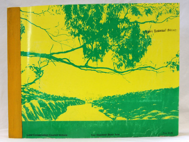
book, Report on the East Gippsland Study Area, June 1974
In 1961 Bruce Evans was elected to the Victorian Legislative Assembly as the member for Gippsland East. He was the party's deputy leader from 1964 to 1970 and its whip from 1970 until his retirement in 1992. "The Land Conservation Council was established by the Land Conservation Act 1970. As one of its three functions, it makes recommendations to the Minister for Planning and Environment with respect to the use of public land, in order to provide for the balanced use of land in Victoria. This report contains the Council’s final recommendations concerning the use of public land in the East Gippsland study area, the boundaries of which correspond to those of the Shire of Orbost. The recommendations in the text are grouped under major headings, such as Parks, State Forest, and so on. " The Council met on seven occasions during the year, and also made visits of inspection to each study area. The Chairman visited Shire Councils in study areas to explain the role and the functions of the Land Conservation Council and to invite submissions on the use of public land in these areas. This is the fourth annual report by the council. This is a useful research tool.A large book 236 pp book with a yellow / gold cover with a green bush scene . The binding is orange. It contains folded maps and information on public land use in East Gippsland.inside - "With Compliments - Bruce Evans, M.P."east-gippsland-study-area conservation public-land-use -
Glen Eira Historical Society
Article - CAULFIELD RAILWAY STATION
This file contains four items: 1/Press cutting from Caulfield Contact, November 1991 (brief report, with photograph of Caulfield Station passengers boarding the steam engine K163 bound for Frankston on Public Transport Open Day). 2/Five pages (stapled together) of photo copied recommendations and assessment by Andrew Ward, March 1995, relating to the history, condition and conservation of the Caulfield Railway Station complex (includes four photocopied photographs). 3/Six pages (stapled together) of material from Heritage Victoria, to B. Evans, Environment Offices, Bayside Trains, 05/03/1999 (two sheets), with enclosure (4 sheets) relating to the cultural heritage significance of the Caulfield Railway Station complex (includes one photocopied photograph). 4/Photocopy of postcard (gelatin silver photograph) of ‘Three new railway lines, train going to Oakleigh [at Caulfield Railway Station]’ c1915, from State Library of Victoria (print dated 12/06/2013).caulfield railway station, b. evans, steam engines, railway stations, railway buildings, ray tonkin, heritage victoria, andrew ward -
 City of Moorabbin Historical Society (Operating the Box Cottage Museum)
Photograph, Black & White Gulliver's House, Marian Lodge, Methodist Childrens Home Cheltemham, c1935
The Methodist Children's Home was originally the home of Mr Gulliver a chemist. It became the centre of a farm at the Home. When the Home was sold to the Catholic Church 1953 it was renamed 'Marian Lodge'. The Methodist Children's Home in Cheltenham was founded c1880 to provide housing for neglected children from the inner city. The Founders aimed to provide regular nourishment, a stable environment and integrate the children into the local community thereby improving their education and lives. However new settlers to Cheltenham area who were seeking a healthier and more respectable lifestyle for their families were not happy to share Church and School with the Home's Children. ( see 00561) 1950's saw a new direction for the support of children and families in poor and difficult situations . The new Methodist Burwood Homes Facility opened in 1951 and children were transferred from Cheltenham in 1952. The land was sold to the St John of God, Catholic Order in1953 who maintained an orphanage until Myer Pty Ltd bought the site in 1967 and constructed the Southland Shopping Centre c1892-1953 The Methodist Children's Home Cheltenham was founded to provide safe accommodation and education for neglected children from the inner city slums. The St John of God Order purchased the Home 1953 and the land was sold to Myer Pty Ltd. who built Southland Shopping Centre 1967 Black & White photograph showing a farm house that was originally owned by Mr Gulliver, a chemist and then the Methodist Children's Home was established 1892. Named Marian Lodge after the St John of God Catholic Order purchased the property in 1953 Back Hand written information st john of god home cheltenham 1953-1967, marian lodge, mr gulliver, pharmacy, methodist childrens home cheltenham 1892-1953, myer southland 1967, city of moorabbin, county of bourke, moorabbin roads board, parish of moorabbin, shire of moorabbin, henry dendy's special survey 1841, were j.b.; bent thomas, o'shannassy john, king richard, charman stephen, highett william, ormond francis, maynard dennis, cheltenham state school no.84, methodist chapel cheltenham, methodist school cheltenham, beaumaris west state school, meeres frederick, meeres walter, education, early settlers, -
 Emerging Writers' Festival
2004 Festival Program, The Melbourne Emerging Writers' Festival 2004 Program
The first Emerging Writers’ Festival was held at the Victoria Hotel in Little Collins Street in January, 2004. The inaugural festival developed out of Express Media's Make It Up zine fair. It brought together the offerings of 68 writers from across Australia in a two-day series of panels, readings, performances and workshops. Express Media ‘s Artistic Director Richard Watts was the driving force behind the ground breaking initiative that was to become the Emerging Writers’ Festival. It was clear to him through the success and the demand of the Make It Up zine fair, which had its origins in 2000, that writing and writers were in the process of radical change and needed a new environment to grow. In response, Express Media formed a partnership with the Victorian Writers’ Centre and held the first Emerging Writers’ Festival with the tagline, the best Australian writers you haven’t heard of yet. The beginnings were humble but the foundations strong. In those early years the festival found its feet, its independence and a loyal and passionate audience.An eight page, stapled program for the 2004 Emerging Writers' Festival printed in black, white and three shades of orange."Featuring the best Australian writers / you haven't heard of (yet) including new, young and / emerging poets, zinesters, short story / writers, spoken word performers, novelists, / screenplay writers / and playwrights, and a range of panels, / readings, workshops as well as an / independent publishers' trade fair."2004 emerging writers' festival, richard watts, express media, literary programming, the wheeler centre, emerging writers', literary, festival, melbourne -
 Bayside Gallery - Bayside City Council Art & Heritage Collection
Work on paper - ink and watercolour, Annette Meikle, Sandringham Club, 1977
In 1977, artist Annette Meikle undertook a commission to illustrate a book recording stories of places and people in the Bayside area. It was published in 1978 as Sandringham Sketchbook, with text by Elizabeth Waters. The sketches were intended to record remaining examples of Bayside’s early architecture and environment, as well as reflect newer architectural changes. Meikle went on to donate 22 of these sketches to Bayside City Council in 2003. In the mid 1870s wealthy solicitor David Abbot bought a large block on the corner of Bamfield Street and Beach Road and built an imposing family home with a stately tower. It featured rare Hawthorn Blacks – hand-made bricks of brown-red with streaks of charcoal black. For many years the home was the most prominent in the district. In 1922 ‘Coggeshall’ was subdivided, and the house was sold to the Sandringham Club, a gentleman’s club that had formed in 1913 and required more space for its growing membership. Members enjoyed lawn tennis courts, a bowling green and a cricket green, as well as a large billiard room. The Sandringham Club still owns ‘Coggeshall’.Annette Meikle, Sandringham Club 1977, ink and watercolour, 25.7 x 35.7 cm. Bayside City Council Art and Heritage Collection. Donated by the artist, 2003annette meikle, sandringham sketchbook, elizabeth waters, sandringham, sandringham club, gentleman’s club, coggeshall, david abbot, historic house -
 Kew Historical Society Inc
Plan - Subdivision Plan, J R Mathers & McMillan, Plan of Subdivision of Part of Crown Portion 83 at Kew : LP6669, 1923-1939
In 1888, in the section of Park Hill Road between Belmont Avenue and Normanby Road there was only one street running between Park Hill Road and Cotham Road. This was Park Road, later to be named Adeney Avenue. Subsequent 20th century subdivisions created the ‘through roads’ of Cecil Street, Wimba Avenue, Florence Avenue, Marshall Avenue, Uvadale Road, and Barrington Avenue. This subdivision represents an attempt by auctioneers, rather than town planners to create an urban environment from larger residential allotments or in many cases farmland. Existing streets such as Parkhill and Normanby Roads provided a convenient starting point for the surveyors, but the Road named ‘Street Street’ indicates the role of the private surveyor in creating streets. Given that a number of allotments are listed as sold on the plan, the street is presumably Cecil Street. Even those lots that had been sold do not quite match the dimensions of the blocks in this parcel of land today, indicating that either further subdivisions or boundary alterations occurred.Subdivision plans are historically important documents used as evidence for the growth of suburbs in Australia. They frequently provide information about when the land was sold as well as evidence relating to surveyors and real estate and financial agents. The numerous subdivision plans in the Kew Historical Society's collection represent working documents, ranging from the initial sketches made in planning a subdivision to printed plans on which auctioneers or agents listed the prices for which individual lots were sold. In a number of cases, the reverse of a subdivision plan in the collection includes a photograph of a house that was also for sale by the agent. These photographs provide significant heritage information relating house design and decoration, fencing and household gardens.The photograph may also be aesthetically significant depending on the importance of the photographic atelier.Hand-drawn subdivision plan of 19 lots facing Parkhill Road, Normanby Road, and an unnamed street [now Cecil Street] in Kew.Estate Agent notes in ink indicate those lots which had sold.subdivision plans - kew, parkhill road - kew, cecil street - kew, normanby road - kew, cecil street -kew, parkhill road - kew, normanby road - kew, crown portion 83 - kew -
 Phillip Island Conservation Society Inc.
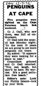
Work on paper - Photocopy of newspaper cutting, Wonthaggi Sentinel, or South Gippsland Sentinel Times, "PENGUINS/AT CAPE"
Cr J Gall was a councilor on the Borough of Wonthaggi Council. The Borough included Cape Paterson, where Cr Gall saw 5 little penguins on the beach. He described them as looking for somewhere to nest – that is, to dig burrows in the coast adjoining the Cape Paterson sandy beach. At that stage, the Wonthaggi state coal mine had been closed for 4 years and Wonthaggi had more emphasis on attracting different industries. There was little interest in flora and fauna of the area at that stage. Cr Gall’s unusual sighting of the Little Penguins possibly nesting at Cape Paterson attracted derision from the other councillors, and also a sarcastic Editor's Note from the newspaper's editor - none of which was not surprising for that era. The Borough of Wonthaggi was later amalgamated with the shires of Phillip Island and Bass, plus other areas of a couple of others local shires in 1994 to form Bass Coast Shire Council, which quickly moved to a heavy emphasis on flora, fauna and the tourism industry related to the environment generally.The article clearly demonstrates the disinterested if not dismissive attitude of the Borough of Wonthaggi councillors and the local newspaper editor at the time towards observations of flora and fauna. However, the article is also an interesting record of 5 Little Penguins being sighted at a beach where they were not known to have previously been seen.Photocopy of Single column newspaper article, black print on white paper. Article has curved line border design on top, sides. Cut off in copy at bottom edge. Five paragraphs in main article, and 1 paragraph at bottom marked: Editor's noteSEN 13 - 7 - 72 (South Gippsland Sentinel Times newspaper, 13th July, 1972)little penguins, fairy penguins, eudyptula minor, penguin behaviour, borough of wonthaggi, cr j gall -
 Melbourne Legacy
Document - Document, report, Staff Organisation Legacy House Present and Future. 20/7/1990, 1990
Legacy staff numbers when this document was written in 1990 were 28 full time staff and 5 part time. In 1982 there were 31 full time and 1 part time. The report discusses increasing the hours of a clerk/typist, not re-appointing a person to replace The Senior Pensions Advocate and a new appointment with computer skills. Wages increased by 53.3%. The wage increase was in line with award rates. Salaries rose by 51.8% from June1983 to April 1990. The report also discusses staff leave, work environment, staff morale and adequacy of office equipment. The future (3-5 years) was discussed in regard to pensions, welfare, housing accommodation for widows and handicapped dependants and fund raising. Location to be checked TBA There were a number of suggestions as to how to maintain current activities and not employ extra staff. The question was asked " Should we now in 1990 be encouraging our Executive Officer to make greater input on our decision making and be given greater resposibility"?Melbourne Legacy has been continually discussing and updating its programe and procedures to maintain its relevance.White foolscap paper with black type, 5 pages about staff organisation.staff, planning -
 Eltham District Historical Society Inc
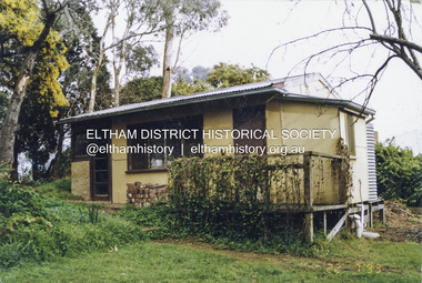
Photograph - Colour Print, Alan Marshall's bungalow, 13 Park West Road, Eltham, 22 July 1993
From 1955 Alan Marshall's home was a bungalow at the rear of his sister's house at Eltham. The first bungalow burnt down. Its replacement shown here still stands. In March 2020 the property was sold. It was last sold previously in November 1982. No mention was made in the advertising regarding the heritage protected bungalow in the rear yard and advertising material presented it as having future potential to develop STCA (Subject To Council Approval). Concerned local members of the community alerted to EDHS to the pending upcoming sale and Council was also alerted to the sale and the potential risk presented to the heritage protected bungalow. In 2021 an updated amendment, C133nill, was made to the Nillumbik Planning Scheme in response to a planning application to develop the property following its sale. The Minster of Planning approved and gazetted the Amendment. Gazettal occurred on 25th November 2021. A copy of the gazetted Amendment is available on website of the Department of Environment, Land, Water and Planning at www.planning.vic.gov.au/schemes-and-amendments/browse-amendments. It was last updated March 2022.Colour photo print 10 x 15 cm, originally stuck down on corflute for displayeltham, alan marshall, alan marshall bungalow, heritage assessment, heritage protection overlay, houses, nillumbik shire council, park west road, heritage overlay ho147 -
 Wooragee Landcare Group
Photograph, circa April 2003
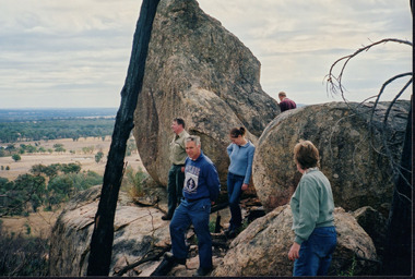
This photograph was taken in the Mount Pilot Chiltern National Park. It was taken during a search for the tiger quoll conducted by a team of volunteers from the Wooragee Landcare Group. The tiger quoll is also known as the spotted-tail quoll and is found in the national park. The 2003 bushfires caused worry for the safety of the tiger quoll, hence the need for a search for it. Mount Pilot Chiltern National Park is located near Chiltern in Victoria. It's most notable landmarks include Mt Pilot and Woolshed Falls. It also has many mines from the Gold Rush in the late 1800s. It is home to much flora and fauna, including the tiger quoll. The park is also home to the box-ironbark forest that once was present in most of north-eastern Victoria. The park is a large tourist destination as in there are many bushwalks and other attractions for visitors. In 2003, bushfires raged through Mount Pilot National Park and destroyed much of the environment. Some of this damage can be seen in the burnt trees in the picture. This photograph represents the work that goes into protecting a important species like the tiger quoll and there has been much work done to preserve it. This photograph was taken when the Wooragee Landcare group went to ensure the survival of this species, highlighting how the tiger quoll is being protected. This photograph also demonstrates the significance of Mount Pilot Chiltern National Park. The park has many special flora and fauna that can only be found in this area. For example, the box-ironbark forest and the tiger quoll. The forest used to stretch over much of north-eastern Victoria and is therefore reminiscent of what that area of Victoria was once like. This park is historical for this reason but it is also historical through it being once goldfields from the Gold Rush in the 1800s.Landscape coloured photograph printed on gloss paperReverse: WAN NA 0ANA2N0 NNN- 1 1636 / [PRINTED] (No.8) / 922mount pilot, mount pilot chiltern national park, chiltern, victoria, landmark, woolshed falls, gold rush, tiger quoll, flora, fauna, spotted tail quoll, marsupial, andy murray, andy murray quolls, carnivorous marsupial, forests, rainforests, coastal heathlands, woodlands, photograph, species, wooragee, wooragee landcare group, wooragee landcare, bushfires, identification, search, dna, droppings, box ironbark forest, ironbark, box iron bark -
 Wooragee Landcare Group
Photograph, 20th June 2004
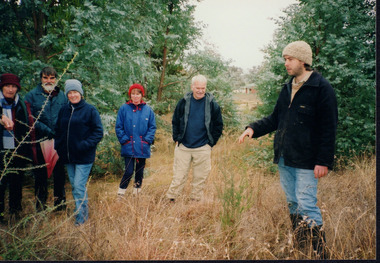
Photo shows (L-R) Bob Dunnett; Tony Prowse; Mary Prowse; Ray Henderson; unknown; Lesley Finedon; unknown; unknown assessing successful stream side rehabilitation at Bev DeJong and Bob Dunnett's place during a paddock demonstration and tree planting field day, called 'Really Successful Tree Planting!' run by Wooragee Landcare on Sunday 20th June 2004. Maintaining and reforesting native trees, shrubs and grasses are really important for a variety of reasons, including creating native habitat and food for birds and other animals, shade, biodiversity, visual appeal, cooling, shade for urban areas, sequestering carbon and conservation among other considerations. The planting must be consistent with the particular needs of the environment, such as trees or shrubs which would naturally occur and are native to the area. Tree planting demonstrations such as this one run by the Landcare Group ensures that the projects are being managed consistently with an overarching commitment to land protection and management and the best methods for best outcomes are employed. This photograph is significant as it provides evidence of a project undertaken by the Wooragee Landcare Group to educate themselves and members of the public on successful techniques needed to plant and maintain trees for replanting in the Wooragee area. The Wooragee Landcare Group has been instrumental in the co-ordination of programs relating to biodiversity protection in the local area, providing great assistance to landholders.Landscape coloured photograph printed on gloss paperReverse: WAN NA 0ANA2N0 NNN+ 1 1636 / [PRINTED] (No.19) / 933wooragee landcare, wooragee landcare group, beechworth, landcare group, wooragee, tree planting, successful tree planting, demonstration, paddock demonstration, tree planting field day, really successful tree planting, land protection and management, land management, native trees, conservation -
 Wooragee Landcare Group
Photograph, 20th June 2004
Photo shows, (L-R): Lesley Finedon; unknown; Mary Prowse; Ann Henderson; Ray Henderson; Luke Bayley (North East CMA), assessing successful stream side rehabilitation at Bev DeJong and Bob Dunnett's place during a paddock demonstration and tree planting field day, called 'Really Successful Tree Planting!' run by Wooragee Landcare on Sunday 20th June 2004. Maintaining and reforesting native trees, shrubs and grasses are really important for a variety of reasons, including creating native habitat and food for birds and other animals, shade, biodiversity, visual appeal, cooling, shade for urban areas, sequestering carbon and conservation among other considerations. The planting must be consistent with the particular needs of the environment, such as trees or shrubs which would naturally occur and are native to the area. Tree planting demonstrations such as this one run by the Landcare Group ensures that the projects are being managed consistently with an overarching commitment to land protection and management and the best methods for best outcomes are employed.This photograph is significant as it provides evidence of a project undertaken by the Wooragee Landcare Group to educate themselves and members of the public on successful techniques needed to plant and maintain trees for replanting in the Wooragee area. The Wooragee Landcare Group has been instrumental in the co-ordination of programs relating to biodiversity protection in the local area, providing great assistance to landholders.WAN NA 0ANAON0 ANN+ 1 1636 / [PRINTED] (No.20) / 934wooragee landcare, wooragee landcare group, beechworth, landcare group, wooragee, tree planting, successful tree planting, demonstration, paddock demonstration, tree planting field day, really successful tree planting, land protection and management, land management, native trees, conservation -
 Ringwood and District Historical Society
Newspaper - Clipping, Norwood High School, Ringwood, Victoria
November 1987 advertisement inviting enrolment enquiries for the following year.Norwood has been established for 29 years and offers an outstanding traditional and broad curriculum in a caring and academic environment. • Student population approximately 1,000 (including 150 Year 12). • Languages: French, Latin, Italian & Indonesian. • Orchestra and Instrumental Training. • Drama Productions. • Extensive Physical Education and Sporting Programme. • Wide Range of V.C.E. Group 1 and Group 11 subjects. • School Uniform. • International Exchange Students. • School Chaplain. • Prefects and S.R.C. • Country Property at Gooram in the Strathbogie Ranges. • Modern Facilities Currently being further upgraded. Advertisement invites Interested parents to visit the School and/or request a Prospectus, and includes contact details for the Principal on 870 5399 for more information.