Showing 1101 items
matching information map
-
 Ballarat Tramway Museum
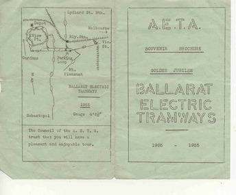
Ephemera - Tour Notes, Australian Electric Traction Association (AETA), "AETA Souvenir Brochure Golden Jubilee" Ballarat 1955, Aug. 1955
Yields information about a Australian Electric Traction Association tour to Ballarat, Golden Jubilee Tour, August 1955 and Ballarat tramcars.An 8 page, duplicated souvenir brochure for AETA tour of Ballarat Trams, on 20/8/55 with brief history, itinerary, map, tram car notes. Gives details of the itinerary for the trip using a 280HP Rail car trip with the forward portion via North Geelong. Duplicated using the Gestetner process. Note the knowledge of the time, with horse tram bodies being reused to form some of the early ESCo. trams. Second copy from donation of the Tom Murray Estate added 25-11-2016 and 3rd copy from Keith Kings papers added 19-3-2017. A copy of this document ex Charles Craig collection was replaced by a better condition one ex Tom Murray - 25-11-2016. Record revised and updated for this replacement. Handle with care - both copies.secv, ballarat tramways, 1955, 50 years of electric trams, aeta -
 Ballarat Tramway Museum
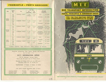
Ephemera - Timetable and map, MTT Perth, "MTT Bus Transport Information 1962" - Perth, 1962
Colour map of Perth bus routes and trolley bus routes on soft card or heavy paper. At time of the 1962 British Empire and Commonwealth Games. Title "MTT Bus Transport Information 1962" - Perth.mtt, perth, bus routes, timetables -
 Ballarat Tramway Museum
Ephemera - Tour Notes, Australian Electric Traction Association (AETA), "AETA Easter 1958, tour notes, Ballarat", Apr. 1958
Yields information about a Australian Electric Traction Association tour to Ballarat, Bendigo and Geelong Tour, Easter 1958 tramcars with maps.A eight page booklet tour notes for AETA's 4th Annual Easter Convention in Melbourne and tour to Ballarat, Sat. 5/4/1958 with brief history, itinerary, map, Geelong map, tram car notes and Bendigo. Duplicated by Gestener process. Copy to be provided if loaned.secv, ballarat, geelong, aeta, bendigo, provincial tramways -
 Ballarat Tramway Museum
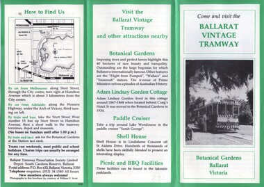
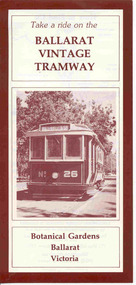
Pamphlet, William. F. Scott, Ballarat Vintage Tramway, Jan. 1985
Yields information about how the BTPS promoted the tramway, with the Design by the printer and William F Scott.Printed 6 page fold out pamphlet on Ballarat Vintage Tramway, Featuring 4 black and white photos, 2 maps; one of old Ballarat system, and one part of Lake Wendouree with green boarders and some type face in green ink. Prepared by W.Scott for BTPS in 1984/85. 2nd copy added 1/1/2012trams, tramways, btps, ballarat vintage tramway, botanical gardens -
 Ballarat Tramway Museum
Pamphlet, Ballarat Tramway Preservation Society (BTPS), Ballarat Vintage Tramway, Jul. 2007
Yields information about how the BTPS promoted the tramway, with the Design by the printer.294.1 - Double side pamphlet advertising Tramway and BTPS, featuring tram 26 on one side and location map and details on reverse. Printed in dark red colour. 2nd copy added 6/5/06 and images added 294.2 - as above, but without ACN Number and red in colour on heavier paper. 2nd copy added 1/10/06 and images updated.trams, tramways, btps, ballarat vintage tramway, botanical gardens -
 Ballarat Tramway Museum
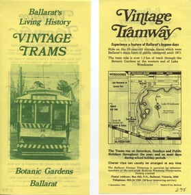
Pamphlet, Ballarat Tramway Preservation Society (BTPS), "Ballarat' Living History- Vintage Trams", Sep. 1984
Yields information about how the BTPS promoted the tramway, with the Design by the printer and the BTPS.Double side paper advertising BTPS with photo of tram 26 (front on prior to reconstruction) printed in green ink on one side, and map and details printed in black ink on reverse side.trams, tramways, btps, ballarat vintage tramway, botanical gardens -
 Ballarat Tramway Museum
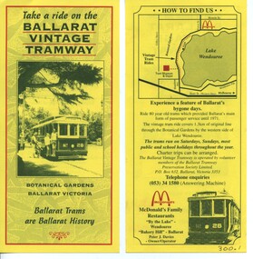
Pamphlet, Ballarat Tramway Preservation Society(BTPS) and Ballarat Tramway Museum, Ballarat Vintage Tramway, 1994
Yields information about how the BTPS promoted the tramway, with the Design by the printer and the BTPS.Printed single sheet pamphlet, advertising tramway at BTPS/BTM featuring tram 26 on side, map and details on reverse. Printed in red and black on yellow paper with McDonalds Logo 300.1 - BTPS Name 300.2 - BTM Nametrams, tramways, btps, btm, ballarat vintage tramway, botanical gardens -
 Ballarat Tramway Museum
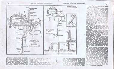
Document - Photocopy, p8/9 of 12/62 Electric Traction, 1970s
Yields information about Ballarat Horse Trams and early ESCo operations through a magazine that featured electric traction operations and information in Australia.Photocopy of p8 & p9 of December 1962 "Electric Traction" fearing map of Ballarat trams in 1904 and 1962 (by Ken McCarthy) and notes on horse trams and the Electric Supply Co. of Victoria. Image of item added 2/11/13trams, tramways, horse trams, esco, map -
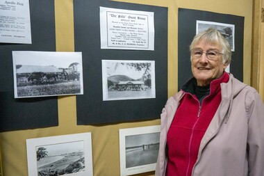
 Apollo Bay Museum
Audio - Norma Begely Oral History Interview April 2023, Apollo Bay
Local Otways residents (Gadubanud Country) were interviewed by artist/researcher Amy Tsilemanis for the 2023 storytelling project Heart Maps, a collaboration with the Apollo Bay Museum and Historical Society. Themes include memories of communication technologies, entertainments, school, work, community, and life near the ocean. More information here: https://amytsilemanis.com.au/portfolio/heart-maps In this interview: teaching, Apollo Bay School, Waratah Caravan Park, 1960s, 1970s, OtwaysMP3 Audio file apollo bay, teaching, caravan park -
 Apollo Bay Museum
Audio - Bill Hurley Fraser Oral History Interview Apollo Bay May 2023
Local Otways residents (Gadubanud Country) were interviewed by artist/researcher Amy Tsilemanis for the 2023 storytelling project Heart Maps, a collaboration with the Apollo Bay Museum and Historical Society. Themes include memories of communication technologies, entertainments, school, work, community, and life near the ocean. More information here: https://amytsilemanis.com.au/portfolio/heart-mapsapollo bay, fishing, seafood -
 Apollo Bay Museum
Audio - Russell Frost Oral History Interview, Apollo Bay, April 2023
Local Otways residents (Gadubanud Country) were interviewed by artist/researcher Amy Tsilemanis for the 2023 storytelling project Heart Maps, a collaboration with the Apollo Bay Museum and Historical Society. Themes include memories of communication technologies, entertainments, school, work, community, and life near the ocean. More information here: https://amytsilemanis.com.au/portfolio/heart-mapsapollo bay, fishing, seafood -
 Apollo Bay Museum
Audio - Val Flitton Oral History Interview Apollo Bay April 2023
Local Otways residents (Gadubanud Country) were interviewed by artist/researcher Amy Tsilemanis for the 2023 storytelling project Heart Maps, a collaboration with the Apollo Bay Museum and Historical Society. Themes include memories of communication technologies, entertainments, school, work, community, and life near the ocean. More information here: https://amytsilemanis.com.au/portfolio/heart-mapsapollo bay, nursing, ww2 -
 Apollo Bay Museum
Audio - Nellie O'Meara Oral History Interview Apollo Bay April 2023
Local Otways residents (Gadubanud Country) were interviewed by artist/researcher Amy Tsilemanis for the 2023 storytelling project Heart Maps, a collaboration with the Apollo Bay Museum and Historical Society. Themes include memories of communication technologies, entertainments, school, work, community, and life near the ocean. More information here: https://amytsilemanis.com.au/portfolio/heart-mapsapollo bay, tourism -
 Apollo Bay Museum
Audio - Bob Telford Oral History Interview Apollo Bay May 2023
Local Otways residents (Gadubanud Country) were interviewed by artist/researcher Amy Tsilemanis for the 2023 storytelling project Heart Maps, a collaboration with the Apollo Bay Museum and Historical Society. Themes include memories of communication technologies, entertainments, school, work, community, and life near the ocean. More information here: https://amytsilemanis.com.au/portfolio/heart-mapsapollo bay, community, radio, youth club -
 Apollo Bay Museum
Audio - Irene Newton Oral History Interview Apollo Bay May 2023
Local Otways residents (Gadubanud Country) were interviewed by artist/researcher Amy Tsilemanis for the 2023 storytelling project Heart Maps, a collaboration with the Apollo Bay Museum and Historical Society. Themes include memories of communication technologies, entertainments, school, work, community, and life near the ocean. More information here: https://amytsilemanis.com.au/portfolio/heart-mapsapollo bay -
 Apollo Bay Museum
Audio - John Marriner Oral History, Apollo Bay April 2023
Local Otways residents (Gadubanud Country) were interviewed by artist/researcher Amy Tsilemanis for the 2023 storytelling project Heart Maps, a collaboration with the Apollo Bay Museum and Historical Society. Themes include memories of communication technologies, entertainments, school, work, community, and life near the ocean. More information here: https://amytsilemanis.com.au/portfolio/heart-mapsapollo bay, hordern vale -
 Apollo Bay Museum
Audio - Val Cameron Oral History, Apollo Bay April 2023
Local Otways residents (Gadubanud Country) were interviewed by artist/researcher Amy Tsilemanis for the 2023 storytelling project Heart Maps, a collaboration with the Apollo Bay Museum and Historical Society. Themes include memories of communication technologies, entertainments, school, work, community, and life near the ocean. More information here: https://amytsilemanis.com.au/portfolio/heart-mapsapollo bay, hospital, nursing -
 Apollo Bay Museum
Audio - Olive and Gordon Currie Oral History, Apollo Bay April 2023
Local Otways residents (Gadubanud Country) were interviewed by artist/researcher Amy Tsilemanis for the 2023 storytelling project Heart Maps, a collaboration with the Apollo Bay Museum and Historical Society. Themes include memories of communication technologies, entertainments, school, work, community, and life near the ocean. More information here: https://amytsilemanis.com.au/portfolio/heart-mapsapollo bay, farming, killala rd -
 Apollo Bay Museum
Audio - Neville Fisk Oral History, Apollo Bay April 2023
Local Otways residents (Gadubanud Country) were interviewed by artist/researcher Amy Tsilemanis for the 2023 storytelling project Heart Maps, a collaboration with the Apollo Bay Museum and Historical Society. Themes include memories of communication technologies, entertainments, school, work, community, and life near the ocean. More information here: https://amytsilemanis.com.au/portfolio/heart-mapsapollo bay, fishing -
 Apollo Bay Museum
Audio - Yvonne Francis Oral History Interview Apollo Bay May 2023
Local Otways residents (Gadubanud Country) were interviewed by artist/researcher Amy Tsilemanis for the 2023 storytelling project Heart Maps, a collaboration with the Apollo Bay Museum and Historical Society. Themes include memories of communication technologies, entertainments, school, work, community, and life near the ocean. More information here: https://amytsilemanis.com.au/portfolio/heart-mapsapollo bay, community radio -
 Apollo Bay Museum
Audio - Bruce Costin John Berry Sylvia Jones Oral History Interview Apollo Bay May 2023
Local Otways residents (Gadubanud Country) were interviewed by artist/researcher Amy Tsilemanis for the 2023 storytelling project Heart Maps, a collaboration with the Apollo Bay Museum and Historical Society. Themes include memories of communication technologies, entertainments, school, work, community, and life near the ocean. More information here: https://amytsilemanis.com.au/portfolio/heart-mapsapollo bay, pubs -
 Apollo Bay Museum
Audio - John Verey Oral History, Apollo Bay April 2023
Local Otways residents (Gadubanud Country) were interviewed by artist/researcher Amy Tsilemanis for the 2023 storytelling project Heart Maps, a collaboration with the Apollo Bay Museum and Historical Society. Themes include memories of communication technologies, entertainments, school, work, community, and life near the ocean. More information here: https://amytsilemanis.com.au/portfolio/heart-mapsapollo bay, golf course, surf lifesaving club -
 Kew Historical Society Inc
Plan, Melbourne & Metropolitan Board of Works : Borough of Kew : Detail Plan No.1576, 1904
The Melbourne and Metropolitan Board of Works (MMBW) plans were produced from the 1890s to the 1950s. They were crucial to the design and development of Melbourne's sewerage and drainage system. The plans, at a scale of 40 feet to 1 inch (1:480), provide a detailed historical record of Melbourne streetscapes and environmental features. Each plan covers one or two street blocks (roughly six streets), showing details of buildings, including garden layouts and ownership boundaries, and features such as laneways, drains, bridges, parks, municipal boundaries and other prominent landmarks as they existed at the time each plan was produced. (Source: State Library of Victoria)This plan forms part of a large group of MMBW plans and maps that was donated to the Society by the Mr Poulter, City Engineer of the City of Kew in 1989. Within this collection, thirty-five hand-coloured plans, backed with linen, are of statewide significance as they include annotations that provide details of construction materials used in buildings in the first decade of the 20th century as well as additional information about land ownership and usage. The copies in the Public Record Office Victoria and the State Library of Victoria are monochrome versions which do not denote building materials so that the maps in this collection are invaluable and unique tools for researchers and heritage consultants. A number of the plans are not held in the collection of the State Library of Victoria so they have the additional attribute of rarity.Original survey plan, issued by the MMBW to a contractor with responsibility for constructing sewers in the area identified on the plan within the Borough of Kew. The plan was at some stage hand-coloured, possibly by the contractor, but more likely by officers working in the Engineering Department of the Borough and later Town, then City of Kew. The hand-coloured sections of buildings on the plan were used to denote masonry or brick constructions (pink), weatherboard constructions (yellow), and public buildings (grey). Development in the 20th century has irreparably altered that part of Kew represented in this plan. In the block bounded by Cotham Road, Charles Street, Wellington Street and Gellibrand; just one house standing in 1903 remains. This block included two of the most historic houses in Kew: ‘Ordsall’ (later ‘Southesk’) and ‘Madford’ (previously ‘Elm Lodge’). Ordsall was the home of the second chairman of Kew, John Halfey. It contained some of the most significant interior murals in Kew, created for Halfey by artists working for Cullen & Co. It was demolished in 1960 to make way for the Kew Civic Centre. Elm Lodge had been built for William Siddeley in ca. 1864. Arthur Septimus King purchased it in 1874. The lower paddocks of Madford were sold in 1905 by his wife to the Borough of Kew and, after landscaping by George and Thomas Pockett, opened as the Alexandra Gardens in 1908. Elm Lodge/Madford was in 1922 to become St. Anthony’s Home for Little Children before its subsequent demolition in the 1980s.melbourne and metropolitan board of works, detail plans, maps - borough of kew, mmbw 1576, cartography -
 Kew Historical Society Inc
Plan, Borough of Kew Detail Plan No.1577, 1904
The Melbourne and Metropolitan Board of Works (MMBW) plans were produced from the 1890s to the 1950s. They were crucial to the design and development of Melbourne's sewerage and drainage system. The plans, at a scale of 40 feet to 1 inch (1:480), provide a detailed historical record of Melbourne streetscapes and environmental features. Each plan covers one or two street blocks (roughly six streets), showing details of buildings, including garden layouts and ownership boundaries, and features such as laneways, drains, bridges, parks, municipal boundaries and other prominent landmarks as they existed at the time each plan was produced. (Source: State Library of Victoria)This plan forms part of a large group of MMBW plans and maps that was donated to the Society by the Mr Poulter, City Engineer of the City of Kew in 1989. Within this collection, thirty-five hand-coloured plans, backed with linen, are of statewide significance as they include annotations that provide details of construction materials used in buildings in the first decade of the 20th century as well as additional information about land ownership and usage. The copies in the Public Record Office Victoria and the State Library of Victoria are monochrome versions which do not denote building materials so that the maps in this collection are invaluable and unique tools for researchers and heritage consultants. A number of the plans are not held in the collection of the State Library of Victoria so they have the additional attribute of rarity.Original survey plan, issued by the MMBW to a contractor with responsibility for constructing sewers in the area identified on the plan within the Borough of Kew. The plan was at some stage hand-coloured, possibly by the contractor, but more likely by officers working in the Engineering Department of the Borough and later Town, then City of Kew. The hand-coloured sections of buildings on the plan were used to denote masonry or brick constructions (pink), weatherboard constructions (yellow), and public buildings (grey). MMBW Plan No.1577 includes some of the most significant houses in Kew: Herbert Henty’s ‘Roxeth’ (now part of Trinity Grammar), ‘Butleigh Wooton’, ‘Bokara’ and ‘Harrow’. It also includes the streets that have since changed their names. That part of College Parade linked to Glenferrie Road is now named College Place, College Parade now extends further north, and Charles Street did not yet reach Barkers Road. Roxeth is one of a number of Henty houses in Kew. Herbert Henty made his home here and was elected a member of Kew Municipal Council in 1864 and mayor in 1868-69. Walter Henry Serle, of Harrow served in the First World War. He was awarded the Military Medal ‘’For conspicuous bravery and devotion to duty. On 29th September near BELLICOURT he showed the greatest bravery and determination when his platoon was attacked by enemy bombing parties. It was due largely to his personal efforts that all the attacks were repulsed. Until wounded, his utter disregard of personal safety and boldness in dealing with the attacks were the means of saving the situation and were an inspiring example to his men.’melbourne and metropolitan board of works, detail plans, maps - borough of kew, mmbw 1577, cartography -
 Kew Historical Society Inc
Plan, Melbourne & Metropolitan Board of Works : Borough of Kew : Detail Plan No.1578, 1904
The Melbourne and Metropolitan Board of Works (MMBW) plans were produced from the 1890s to the 1950s. They were crucial to the design and development of Melbourne's sewerage and drainage system. The plans, at a scale of 40 feet to 1 inch (1:480), provide a detailed historical record of Melbourne streetscapes and environmental features. Each plan covers one or two street blocks (roughly six streets), showing details of buildings, including garden layouts and ownership boundaries, and features such as laneways, drains, bridges, parks, municipal boundaries and other prominent landmarks as they existed at the time each plan was produced. (Source: State Library of Victoria). This plan forms part of a large group of MMBW plans and maps that was donated to the Society by the Mr Poulter, City Engineer of the City of Kew in 1989. Within this collection, thirty-five hand-coloured plans, backed with linen, are of statewide significance as they include annotations that provide details of construction materials used in buildings in the first decade of the 20th century as well as additional information about land ownership and usage. The copies in the Public Record Office Victoria and the State Library of Victoria are monochrome versions which do not denote building materials so that the maps in this collection are invaluable and unique tools for researchers and heritage consultants. A number of the plans are not held in the collection of the State Library of Victoria so they have the additional attribute of rarity.Original survey plan, issued by the MMBW to a contractor with responsibility for constructing sewers in the area identified on the plan within the Borough of Kew. The plan was at some stage hand-coloured, possibly by the contractor, but more likely by officers working in the Engineering Department of the Borough and later Town, then City of Kew. The hand-coloured sections of buildings on the plan were used to denote masonry or brick constructions (pink), weatherboard constructions (yellow), and public buildings (grey). MMBW Plan No.1578 is significant in that it defines the extent of two private schools: Xavier College and Kew High School (now part of Trinity Grammar) by 1904. In relation to the latter, the plan clarifies which buildings the High School operated from behind the mansion ‘Molina’. Established in 1902, Trinity Grammar was to later lease and subsequently buy Molina (now ‘Merritt House’) and ‘Elsinore’ (now ‘Roberts House’). Xavier College had been established in 1872. This 1904 plan delineates the West Wing and the Great Hall (built in 1890).melbourne and metropolitan board of works, detail plans, maps - borough of kew, mmbw 1578, cartography -
 Kew Historical Society Inc
Plan, Melbourne & Metropolitan Board of Works. Borough of Kew Detail Plan No.1579, 1904
The Melbourne and Metropolitan Board of Works (MMBW) plans were produced from the 1890s to the 1950s. They were crucial to the design and development of Melbourne's sewerage and drainage system. The plans, at a scale of 40 feet to 1 inch (1:480), provide a detailed historical record of Melbourne streetscapes and environmental features. Each plan covers one or two street blocks (roughly six streets), showing details of buildings, including garden layouts and ownership boundaries, and features such as laneways, drains, bridges, parks, municipal boundaries and other prominent landmarks as they existed at the time each plan was produced. (Source: State Library of Victoria). This plan forms part of a large group of MMBW plans and maps that was donated to the Society by the Mr Poulter, City Engineer of the City of Kew in 1989. Within this collection, thirty-five hand-coloured plans, backed with linen, are of statewide significance as they include annotations that provide details of construction materials used in buildings in the first decade of the 20th century as well as additional information about land ownership and usage. The copies in the Public Record Office Victoria and the State Library of Victoria are monochrome versions which do not denote building materials so that the maps in this collection are invaluable and unique tools for researchers and heritage consultants. A number of the plans are not held in the collection of the State Library of Victoria so they have the additional attribute of rarity.Original survey plan, issued by the MMBW to a contractor with responsibility for constructing sewers in the area identified on the plan within the Borough of Kew. The plan was at some stage hand-coloured, possibly by the contractor, but more likely by officers working in the Engineering Department of the Borough and later Town, then City of Kew. The hand-coloured sections of buildings on the plan were used to denote masonry or brick constructions (pink), weatherboard constructions (yellow), and public buildings (grey). While MMBW Plan No.1579 does not include many buildings, those that it does show are significant to Kew’s history. These include the ‘Kew [Railway] Station’ in Denmark Street and the ‘Recreation Hall’ and rear courts off Wellington Street. The plan shows the outline of the Recreation Hall, constructed in 1880, at the rear of which is listed a bowling green, two tennis courts, a ‘skittle alley’ and a pavilion. When the Hall was first built, the Kew Cricket Club occupied an adjacent ground, however in 1885 this was acquired by the State Government as the future location of the Kew Railway Station. The Plan also shows a single oval at Xavier College. This oval was completed in 1883. One of the current ovals conforms to this oval’s original shape and position in the school grounds.melbourne and metropolitan board of works, detail plans, maps - borough of kew, mmbw 1579, cartography -
 Kew Historical Society Inc
Plan, Melbourne and Metropolitan Board of Works, Borough of Kew : Detail Plan No.1580, 1904
The Melbourne and Metropolitan Board of Works (MMBW) plans were produced from the 1890s to the 1950s. They were crucial to the design and development of Melbourne's sewerage and drainage system. The plans, at a scale of 40 feet to 1 inch (1:480), provide a detailed historical record of Melbourne streetscapes and environmental features. Each plan covers one or two street blocks (roughly six streets), showing details of buildings, including garden layouts and ownership boundaries, and features such as laneways, drains, bridges, parks, municipal boundaries and other prominent landmarks as they existed at the time each plan was produced. (Source: State Library of Victoria)This plan forms part of a large group of MMBW plans and maps that was donated to the Society by the Mr Poulter, City Engineer of the City of Kew in 1989. Within this collection, thirty-five hand-coloured plans, backed with linen, are of statewide significance as they include annotations that provide details of construction materials used in buildings in the first decade of the 20th century as well as additional information about land ownership and usage. The copies in the Public Record Office Victoria and the State Library of Victoria are monochrome versions which do not denote building materials so that the maps in this collection are invaluable and unique tools for researchers and heritage consultants. A number of the plans are not held in the collection of the State Library of Victoria so they have the additional attribute of rarity.Original survey plan, issued by the MMBW to a contractor with responsibility for constructing sewers in the area identified on the plan within the Borough of Kew. The plan was at some stage hand-coloured, possibly by the contractor, but more likely by officers working in the Engineering Department of the Borough and later Town, then City of Kew. The hand-coloured sections of buildings on the plan were used to denote masonry or brick constructions (pink), weatherboard constructions (yellow), and public buildings (grey). The area represented in this detail plan has undergone significant change during the 20th century. The widening of High Street in the 1930s and 1950s involved the shops on the south side of High Street being demolished and later rebuilt to fit the widened street. Another significant loss was the mansion ‘Drayton’ fronting Wellington Street, owned at this stage by Susannah Fenton. Her family name would later to be given to Fenton Way, which was to be built over the grounds of the house following its demolition. The plan of the garden is particularly interesting, containing a batten dome fronting Wellington Street, an ornamental pond, a fountain and a brick and glass conservatory. The notes by the plumbing contractor on this plan are particularly detailed. Pink borders delineate the ownership of the varying parcels of land. Some of the better known owners listed include the real estate agent Cr. Henry de Castres Kellett (bt) and John Padbury, the funeral director. This particular plan provides a clear view of the configuration of the Kew Junction in 1903 and the commercial buildings that surrounded it.melbourne and metropolitan board of works, detail plans, maps - borough of kew, mmbw 1580, cartography -
 Kew Historical Society Inc
Plan, Melbourne & Metropolitan Board of Works : Borough of Kew : Detail Plan No.1581, 1904
The Melbourne and Metropolitan Board of Works (MMBW) plans were produced from the 1890s to the 1950s. They were crucial to the design and development of Melbourne's sewerage and drainage system. The plans, at a scale of 40 feet to 1 inch (1:480), provide a detailed historical record of Melbourne streetscapes and environmental features. Each plan covers one or two street blocks (roughly six streets), showing details of buildings, including garden layouts and ownership boundaries, and features such as laneways, drains, bridges, parks, municipal boundaries and other prominent landmarks as they existed at the time each plan was produced. (Source: State Library of Victoria)This plan forms part of a large group of MMBW plans and maps that was donated to the Society by the Mr Poulter, City Engineer of the City of Kew in 1989. Within this collection, thirty-five hand-coloured plans, backed with linen, are of statewide significance as they include annotations that provide details of construction materials used in buildings in the first decade of the 20th century as well as additional information about land ownership and usage. The copies in the Public Record Office Victoria and the State Library of Victoria are monochrome versions which do not denote building materials so that the maps in this collection are invaluable and unique tools for researchers and heritage consultants. A number of the plans are not held in the collection of the State Library of Victoria so they have the additional attribute of rarity.Original survey plan, issued by the MMBW to a contractor with responsibility for constructing sewers in the area identified on the plan within the Borough of Kew. The plan was at some stage hand-coloured, possibly by the contractor, but more likely by officers working in the Engineering Department of the Borough and later Town, then City of Kew. The hand-coloured sections of buildings on the plan were used to denote masonry or brick constructions (pink), weatherboard constructions (yellow), and public buildings (grey). The streets and built structures in this plan were surveyed in 1903 and released to contractors in 1904. In addition to the designation of building types by colour, the plan includes detailed descriptions of land use and ownership. While many buildings remain from this period, a number of the buildings represented have been demolished including the original Kew Town Hall, and the Congregational and Roman Catholic churches in Walpole Street. While the mansion ‘Illapa’ in Princess Street is still extant – now part of ‘Rylands’ – the neighbouring mansion ‘Elsmere’ was demolished some decades ago. Rivalling Illapa and Elsmere in size were two mansions in Walpole Street, one named on the plan as ‘Gnarlbine’. Over time, Kew Junction and the south side of High Street have been reconfigured and widened, so that the commercial buildings on the corner of Princess and High Street no longer exist. A surprising feature of this part of central Kew to the northwest of Kew Junction is the amount of vacant land. In a number of cases, this land is noted by the contractor as used for vegetable gardens.melbourne and metropolitan board of works, detail plans, maps - borough of kew, mmbw 1581, cartography -
 Kew Historical Society Inc
Plan, Melbourne & Metropolitan Board of Works : Borough of Kew : Detail Plan No.1582, 1904
The Melbourne and Metropolitan Board of Works (MMBW) plans were produced from the 1890s to the 1950s. They were crucial to the design and development of Melbourne's sewerage and drainage system. The plans, at a scale of 40 feet to 1 inch (1:480), provide a detailed historical record of Melbourne streetscapes and environmental features. Each plan covers one or two street blocks (roughly six streets), showing details of buildings, including garden layouts and ownership boundaries, and features such as laneways, drains, bridges, parks, municipal boundaries and other prominent landmarks as they existed at the time each plan was produced. (Source: State Library of Victoria)This plan forms part of a large group of MMBW plans and maps that was donated to the Society by the Mr Poulter, City Engineer of the City of Kew in 1989. Within this collection, thirty-five hand-coloured plans, backed with linen, are of statewide significance as they include annotations that provide details of construction materials used in buildings in the first decade of the 20th century as well as additional information about land ownership and usage. The copies in the Public Record Office Victoria and the State Library of Victoria are monochrome versions which do not denote building materials so that the maps in this collection are invaluable and unique tools for researchers and heritage consultants. A number of the plans are not held in the collection of the State Library of Victoria so they have the additional attribute of rarity.Original survey plan, issued by the MMBW to a contractor with responsibility for constructing sewers in the area identified on the plan within the Borough of Kew. The plan was at some stage hand-coloured, possibly by the contractor, but more likely by officers working in the Engineering Department of the Borough and later Town, then City of Kew. The hand-coloured sections of buildings on the plan were used to denote masonry or brick constructions (pink), weatherboard constructions (yellow), and public buildings (grey). Public buildings, coloured grey on the Plan 1582 include the police station and post office, churches and schools. The earliest church school, Common School No.356 was located at the rear of the Congregational Church in Peel Street. It was constructed in 1859. The first buildings of Kew Primary School No.1075 on the other side of Peel Street were constructed in 1871. The school in 1903 only occupied a small fraction of its current site. In 1903, where the rear playground is now located, were two weatherboard and one brick villa. Trinity Grammar School was founded in 1902 and opened in the Parish Hall at the rear of Holy Trinity Anglican Church. It was not to move to its current site until 1906. The outline of the building housing the Kew Fire Brigade in the centre of the north side of Walton Street is shown but not named on the plan. Further down Pakington Street stood the two-storey Italianate mansion ‘Overton’. The home of Stanford Chapman, it was to be featured in the Imperial Institute series of bromide photographs of Victoria, Vol. 1: Homes and scenery. It was later to become a boarding house before it was later demolished.melbourne and metropolitan board of works, detail plans, maps - borough of kew, mmbw 1582, cartography -
 Kew Historical Society Inc
Plan, Melbourne & Metropolitan Board of Works : Borough of Kew : Detail Plan No.1585, 1904
The Melbourne and Metropolitan Board of Works (MMBW) plans were produced from the 1890s to the 1950s. They were crucial to the design and development of Melbourne's sewerage and drainage system. The plans, at a scale of 40 feet to 1 inch (1:480), provide a detailed historical record of Melbourne streetscapes and environmental features. Each plan covers one or two street blocks (roughly six streets), showing details of buildings, including garden layouts and ownership boundaries, and features such as laneways, drains, bridges, parks, municipal boundaries and other prominent landmarks as they existed at the time each plan was produced. (Source: State Library of Victoria)This plan forms part of a large group of MMBW plans and maps that was donated to the Society by the Mr Poulter, City Engineer of the City of Kew in 1989. Within this collection, thirty-five hand-coloured plans, backed with linen, are of statewide significance as they include annotations that provide details of construction materials used in buildings in the first decade of the 20th century as well as additional information about land ownership and usage. The copies in the Public Record Office Victoria and the State Library of Victoria are monochrome versions which do not denote building materials so that the maps in this collection are invaluable and unique tools for researchers and heritage consultants. A number of the plans are not held in the collection of the State Library of Victoria so they have the additional attribute of rarity.Original survey plan, issued by the MMBW to a contractor with responsibility for constructing sewers in the area identified on the plan within the Borough of Kew. The plan was at some stage hand-coloured, possibly by the contractor, but more likely by officers working in the Engineering Department of the Borough and later Town, then City of Kew. The hand-coloured sections of buildings on the plan were used to denote masonry or brick constructions (pink), weatherboard constructions (yellow), and public buildings (grey). This plan, which covers parts of High Street, Pakington Street and Derby Street is dominated by two historic Kew mansions: ‘Konetta’ and ‘Ramornie’. Ramornie was constructed in 1890 for James Maitland Campbell, three times Mayor of Kew. Sold in 1940, it became a boarding house known as ‘The Towers’. Now a private residence again, it has only one of its three balconies remaining. The location of the missing two balconies can be seen on the plan. In 1903, the grounds of Ramornie included a large tennis court fronting Pakington Street. The rear of the property is shown as extending to Cobden Street. One of Kew’s oldest hotels, the Prospect Hill Hotel on the corner of High and Cobden Street was established in 1858. The outline of the hotel shown on the plan represents the second building on the site. During the 19th century it was often used for electoral meetings. The Prospect Hill Hotel was to be redeveloped again in 1928, by the local architect Robert McIntyre. Since the 1980s, the hotel has been a live music venue, the home of the Melbourne Jazz Club, a restaurant and a liquor outlet.melbourne and metropolitan board of works, detail plans, maps - borough of kew, mmbw 1585, cartography