Showing 749 items matching "land grant"
-
 Federation University Historical Collection
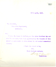
Letter - Letterbook, Ballarat School of Mines Letterbook, 1915 to 1916, 1916
... land...leipson...h.s. lawson...a. levy...scarsdale gold mines...w.k. moss...fred martell...e.j. mcconnen...read murphy...h. morris...leongatha...maurice claude...j. middleton...j.c. molley...e. merlin...e.f. pitman...p. pringle...rumble...dr robin...edgar richard...g. remfry...g. robertson...james rich...a. ross...d. l. stirling...s. stretch...c. skilbeck...r. strachan...w.k. thomson...grant...Barker Library (top floor) Mount Helen goldfields The letter book related to outward letters from the Ballarat School of Mines. ballarat school of mines correspondence murphy vaughan victor greenhalgh irvine coulter lancelot austin l.s.g.p. austin adcock james bickett bickett tunbridge tucker desnoy phillips edgar mcconnon revill tinworth r.o. buchanan john dulfer stanley westcott wolfram assay anzac medallion beaufort house ballarat eight hours' anniversary last chance mine evan walker norman carmichael doney thomas doolan harold wakeling bowman james early garry eason abrams bennett duthie harry fern hetherington hutchinson collyeer colom carew-smyth ponsonby carew-smyth donald clark george swinburne bev syliva hestor darby joy winifred barry judd c.c. campbell cathcart centrel gold mining co adcockbawden benevolent asylum ditchburn doctor spring doepel and chandler eureka tile company pitfield edwads pyrites works embling fleay c.e. fenner mount rowan gower greenhalgh c. hosking murtoa c.a. hoadley harold herbert jolly kenny kelsall kerr architect a.m. lilburne lemmon andrew land leipson h.s. lawson a. levy scarsdale gold mines w.k. moss fred martell e.j. mcconnen read murphy h. morris leongatha maurice claude j. middleton j.c. molley e. merlin e.f. pitman p. pringle rumble dr robin edgar richard g. remfry g. robertson james rich a. ross d. l. stirling s. stretch c. skilbeck r. strachan w.k. thomson grant taylor j.h. tundbury v.e. reeves tin mining co. hobart vernon hilda wardle daylesford waller whitloa w. watson b. whitington j.b. robinson k. hamilton photography j.m. sutherland j.h. scullin scholarship w.h. wesley gundagai a.t. o'meara associated smelters port pirrie assayer telegraphy t. williams d.l. stirling edward finnis norman tinworth j.y. mcdonald h.s. summers geology homeward bound bon accord gmc e.t. vane a.d. dunstan maughan cox g.s. richards westcott w.l. carroll turnbull l. vernon s. nightingale cathcart central gold mining company cathcart a.j. moffit v.e. reevesr. mcmillan w. nankervis w.h. clutterbuck j.m. wesley e. dooley olive mckillop dana street primary school shelter shed ballarat junior technical school british nationality and aliens act war relief fund s. hylton bravo queensland molasses co ethel merlin a.e. poulton commercial winifred joy c. adcock lancelot st.g.p. austin herbert p. bennett a. bray fonald clark walter collyer o.f. colom g.e. desnoy f.w.r. doney brian h. duthie a. gordon g.m. hetherington kath hutchinson baryr judd j. kean john y. mcdonald j. murray a.f. phillips c.c. phillips john mck. sutherland bev sylvia r.e. tunbridge miachel vaughan p. vawdey h.j. vernon harold g. wakeling pharmacy board pharmacy r. cutter ballarat technical art school building dalgety & co. h.s.w. lawson a.h. powell australian institute of engineers eight hours' anniversary committee silberberg beckman's thermometer Miss Abrams Business College A bound leatherbound book with marble endpapers. ...The letter book related to outward letters from the Ballarat School of Mines.A bound leatherbound book with marble endpapers. The contents are copies of outward letters from the Ballarat School of Mines from July 1915 to May 1916. Page 807 relates to the Ballarat Eight Hours' Anniversary Committee (J. Kean) Page 906 - Letter from L. Austin (Ballarat School of Mines Registrar) concerning the appointment of Winifred Joy and Hestor Darby as assistants to Miss Abrams to the Ballarat School of Mines Senior Commercial Classes. ballarat school of mines, correspondence, murphy, vaughan, victor greenhalgh, irvine coulter, lancelot austin, l.s.g.p. austin, adcock, james bickett, bickett, tunbridge, tucker, desnoy, phillips, edgar mcconnon, revill tinworth, r.o. buchanan, john dulfer, stanley westcott, wolfram, assay, anzac medallion, beaufort house, ballarat eight hours' anniversary, last chance mine, evan walker, norman carmichael, doney, thomas doolan, harold wakeling, bowman, james early, garry eason, abrams, bennett, duthie, harry fern, hetherington, hutchinson, collyeer, colom, carew-smyth, ponsonby carew-smyth, donald clark, george swinburne, bev syliva, hestor darby, joy winifred, barry judd, c.c. campbell, cathcart centrel gold mining co, adcockbawden, benevolent asylum, ditchburn, doctor spring, doepel and chandler, eureka tile company, pitfield, edwads pyrites works, embling, fleay, c.e. fenner, mount rowan, gower, greenhalgh, c. hosking, murtoa, c.a. hoadley, harold herbert, jolly, kenny, kelsall, kerr, architect, a.m. lilburne, lemmon, andrew land, leipson, h.s. lawson, a. levy, scarsdale gold mines, w.k. moss, fred martell, e.j. mcconnen, read murphy, h. morris, leongatha, maurice claude, j. middleton, j.c. molley, e. merlin, e.f. pitman, p. pringle, rumble, dr robin, edgar richard, g. remfry, g. robertson, james rich, a. ross, d. l. stirling, s. stretch, c. skilbeck, r. strachan, w.k. thomson, grant taylor, j.h. tundbury, v.e. reeves, tin mining co. hobart, vernon, hilda wardle, daylesford, waller, whitloa, w. watson, b. whitington, j.b. robinson, k. hamilton, photography, j.m. sutherland, j.h. scullin, scholarship, w.h. wesley, gundagai, a.t. o'meara, associated smelters port pirrie, assayer, telegraphy, t. williams, d.l. stirling, edward finnis, norman tinworth, j.y. mcdonald, h.s. summers, geology, homeward bound bon accord gmc, e.t. vane, a.d. dunstan, maughan, cox, g.s. richards, westcott, w.l. carroll, turnbull, l. vernon, s. nightingale, cathcart central gold mining company cathcart, a.j. moffit, v.e. reevesr. mcmillan, w. nankervis, w.h. clutterbuck, j.m. wesley, e. dooley, olive mckillop, dana street primary school shelter shed, ballarat junior technical school, british nationality and aliens act, war relief fund, s. hylton bravo, queensland molasses co, ethel merlin, a.e. poulton, commercial, winifred joy, c. adcock, lancelot st.g.p. austin, herbert p. bennett, a. bray, fonald clark, walter collyer, o.f. colom, g.e. desnoy, f.w.r. doney, brian h. duthie, a. gordon, g.m. hetherington, kath hutchinson, baryr judd, j. kean, john y. mcdonald, j. murray, a.f. phillips, c.c. phillips, john mck. sutherland, bev sylvia, r.e. tunbridge, miachel vaughan, p. vawdey, h.j. vernon, harold g. wakeling, pharmacy board, pharmacy, r. cutter, ballarat technical art school building, dalgety & co., h.s.w. lawson, a.h. powell, australian institute of engineers, eight hours' anniversary committee, silberberg, beckman's thermometer, miss abrams business college -
 Federation University Historical Collection
Documents - Reports, Unidentified Large Cat Sightings in Maryborough
... grant...elliott...anderson...stone...irvine...douglas...stewart...long...mythical...myth...folklore...australian mythical animals collection...david waldron...Land...Australian Animal Folklore Collection cat ferral cat puma mountain lion Maryborough Maryborough Victoria DS Saunders bryan walters bernie Mall peter chapple. graham george Australian Cougar felid pamela Parker alan Foskett Daisy Hill panther john dix ray elliott dennis wiley police sightings graham hunt Brian Douglas Stuart Mill graeme grant A. venes avoca julie hobbs greg gallagher taltarni moonambel fred beach majorca Michael rayner Chateau Remy John Robb Wayne Irvine Brian anderson Peter Davies talbot Joyce Davies Tom Davies Len farthing Barry rinaldi Edward stone brian Stone Judith tranter Alan Poole Shane Long Jim Smith Lloyd Forge Carisbrook Murray Henderson Doug Grose John Higgins footprint Cast Australian dasyurids felis concolor lioness lion Shane Long Wareek koo-jar hill american troops betley cat daisy hill cat phelan road cat amherst cat john higgin angus Reynolds betley Tiger tim clark walters cougar catcher identification chart David Towler bob carr rare fauna research society lancefield cat bernie mace robert pattison Bryan de lacy romsey murray henderson brian collinson neil grummett grummett kenneth Lamont Lamont foskett hobbs rinaldi poole forge henderson grant elliott anderson stone irvine douglas stewart long mythical myth folklore australian mythical animals collection david waldron Land Protection d.s. saunders judith henke ravenswood wedderburn feral cat laanecoorie shellbourne barru rinaldi lan poole dorothy smith amherst cemetery graham grant maryborough advertiser Central victorian cat st arnaud Kyneton Shane one Wareek lack of fossil evidence koo-jat hill cougar hill plaster casts lummis goldsborough Ian Lummis Hamilton Swan hill wodonga A number of A4 printouts relating to large cat sightings in the Maryborough (Vic) area, many reported by the Marlborough Advertiser. ...The folder or correspondence is the result of a Freedom of Informaition request made to the Department of Primary Industries in 2011. The folder was collected for research being conducted by David Waldron. John Higgins, managing editor of the Maryborough Advertiser was interested in sightings of what some suggested to be a puma or mountain lion in Central Victoria. A number of A4 printouts relating to large cat sightings in the Maryborough (Vic) area, many reported by the Marlborough Advertiser. The large cat referred to is often referred to as a Puma or Mountain Lion. (.7) Profile of Central Victorian Cat Australian Animal Folklore Collectionaustralian animal folklore collection, cat, ferral cat, puma, mountain lion, maryborough, maryborough victoria, ds saunders, bryan walters, bernie mall, peter chapple. graham george, australian cougar, felid, pamela parker, alan foskett, daisy hill, panther, john dix, ray elliott, dennis wiley, police sightings, graham hunt, brian douglas, stuart mill, graeme grant, a. venes, avoca, julie hobbs, greg gallagher, taltarni, moonambel, fred beach, majorca, michael rayner, chateau remy, john robb, wayne irvine, brian anderson, peter davies, talbot, joyce davies, tom davies, len farthing, barry rinaldi, edward stone, brian stone, judith tranter, alan poole, shane long, jim smith, lloyd forge, carisbrook, murray henderson, doug grose, john higgins, footprint cast, australian dasyurids, felis concolor, lioness, lion, shane long, wareek, koo-jar hill, american troops, betley cat, daisy hill cat, phelan road cat, amherst cat, john higgin, angus reynolds, betley tiger, tim clark, walters cougar catcher, identification chart, david towler, bob carr, rare fauna research society, lancefield cat, bernie mace, robert pattison, bryan de lacy, romsey, murray henderson, brian collinson, neil grummett, grummett, kenneth lamont, lamont, foskett, hobbs, rinaldi, poole, forge, henderson, grant, elliott, anderson, stone, irvine, douglas, stewart, long, mythical, myth, folklore, australian mythical animals collection, david waldron, land protection, d.s. saunders, judith henke, ravenswood, wedderburn, feral cat, laanecoorie, shellbourne, barru rinaldi, lan poole, dorothy smith, amherst cemetery, graham grant, maryborough advertiser, central victorian cat, st arnaud, kyneton, shane one wareek, lack of fossil evidence, koo-jat hill, cougar hill, plaster casts, lummis, goldsborough, ian lummis, hamilton, swan hill, wodonga -
 Federation University Historical Collection
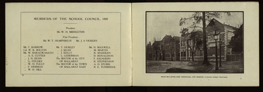
Booklet, The Ballarat School of Mines and Industries 1870-1920 Jubilee Booklet, 1920 (estimated)
... land. In these circumstances the suggestions to found a School of Mines met with ready acceptance. The late Mr James M. Bickett had the honor of bringing forward the proposition at a meeting of the Ballarat Mining Board in October, 1869. it was agreed to, and the Government, having been approached for assistance, granted a lease of the old Supreme Court buildings at a nominal reantal. ...land. In these circumstances the suggestions to found a School of Mines met with ready acceptance. The late Mr James M. Bickett had the honor of bringing forward the proposition at a meeting of the Ballarat Mining Board in October, 1869. it was agreed to, and the Government, having been approached for assistance, granted a lease of the old Supreme Court buildings at a nominal reantal. ...The first school of Mines in Australia was established at Ballarat in 1870. At the time of its jubilee (1930) the following people were members of the School Council: W.H. Middleton (President), W.T. Humphreys (VP), J.S. Vickery (VP), F. Barrow, Col. W.K. Bolton, William Baragwanath, A.E. Cutter, J.N. Dunn, G. Fitches, W.H. Fleay, F. Herman. W.D. Hill, T. Hurley, K. Kean. J. Kelly, L. Lederman, Mayor of Ballarat, Mayour of Ballarat East, D. Maxwell, M. Martin, R. Maddern, D. Ronaldson, F. Saunders, R. Stephenson, A.O. Stubbs, R.E. Tunbridge. The School Staff in 1920 comprised: Herbert H. Smith, Walter Rowbotham, Reginald L. Cutter, M.C. Young, Hilda Wardle, M. Wiliamson, P.S. Richards, L.H. Archibald, J. Woods, Ken Moss, W. Kenneth, Mrs McIlvena. B. Robinson, S. Rowe, E. Hope-Jones, Miss Abrams, L.St.G.P. Austin, Alfred Mica Smith, J.R. Pound, Herbert R. Murphy, N.H. Junner, Maurice Copland, L.H. Archibald, E.J.A. McConnon, Newton King, D.m. Hull, T.R. Gordon, John M. Sutherland, T.K. Jebb, Dick Richards, C. Tonkin, A.W. Steane, J. Paterson, H.W. Malin, R.V. Maddison, S.M. Mayo, F.A. King, W.H. Steane, T.R. Gordon, T.A. Williams, H. Waldron, G. Black, E.J. McConnon, R.V. Duncan. R. Cutter, E.G. Vawdrey, Hilda WardleWhite stapled booklet - landscape format - 20pp + soft covers with blue writing. Includes an historical sketch of the Ballarat School of Mines. Contains images of the school from around 1920. The history outlined in the booklet follows: 'Ballarat has helped to influence the life and destinies of Australia in many ways, the recital of which would perhaps prove tedious to the citizens of less favoured localities! However, it can be said, without much fear of contradiction, that only less known thought Australia than its fame as a gold field is the reputation won for it by its school of Mines, ... Ballarat was still quite a new place when the School was founded, but a very propserous and popular place all the same, with a go-ahead lot of citizens brim full of the spirit of enterprise which seemsto animate mining populations generally. Money was plentiful, and they launched out into ventures, which later, were to develop and take the place of the gold mines, while what is more to the point, they understood the value of education. the old digging days were passing away. So far as Ballarat itself was concerned the day of the cradle and tin dish had already passed into an antiquity "as dead and distant as the age of the Tubal Caon," said dir redmond Barry on declaring the School open. Mining had become a serious business, and the mining engineer, the metallurgist, and the geologist had become a power in the land. In these circumstances the suggestions to found a School of Mines met with ready acceptance. The late Mr James M. Bickett had the honor of bringing forward the proposition at a meeting of the Ballarat Mining Board in October, 1869. it was agreed to, and the Government, having been approached for assistance, granted a lease of the old Supreme Court buildings at a nominal reantal. A modest sum, including 100 pounds from the Borough Council of Ballarat West, was subscribed by a number of sympathisers, and on the 26th October, 1870, the inaugural address was delivered by Sir Redmond Barry, the first President of the School. Classes were commenced on the 23rd January, 1871. The students at first were mostly adults. They were chiefly men emloyed at the mines, who had the wisdom and energy to devote their spare time to study, and, though their attendance was somewhat irregular, they made very good progress. Old prints which have been preserved show them at work at furnaces, big bearded men of the old-fashioned type of miner. It is interesting to note that among those who gave evidence and encouragement was Sir Roderick Murchison, who many years before had advised Cornish miners to emigrate to Australia to search for gold, and who in 1848 was in possession of gold ore sent from this country. Sir Roderick sent a parcel of books for the library, and gave useful advice as to the curriculum which should be adopted. The Museum, which now contains a most valuable collection of minerals, was one of the first things attended to, and the reports presented to the Council from time to time speak of additions being made from all parts of the world. New equipment was constantly being added to the School, a good deal of assay work was done, and some specimens were sent from the East Indies for examination as far back as 1873. By this time there was a difficulty in providing accomodation for the students who wished to enrol, and the number of instructors had grown from two to four. In 1882 the first building was being erected on what was then part of the gaol reserve. A little more than ten years afterwards a buildnig formerly serving as a Methodist Church was absorbed, while later on, the demand for accomodation increasing, the attack upon the gaol was renewed. The School continued to grow in reputation and size, and became the science centre of the district, and in 1889 a learge new building was opened by Sir Alexander Peacock. Students came from over seas as well as from all the States of Australia, and after going through their courses they took with them the name and fame of the old School to all parts of the globe. School of Mines boys have played a great part in developing the mining fields of Western Australia, South Australia, and africa, while old students who have made a name in their profession are constantly dropping in to see how the old place is getting along. It was not to be expected, however, that the Ballarat School would be left without rivals, its very success inspiring competition. Mining Schools were started in other parts of Australia, and, at the same time, Victoria ceased to hold first place as a mining state. On the other hand there was a great advance in manufacturing, and the demand for technicaly trained men became a great and as insistent as ever it had been for trained mining men. The Council was quick to adapt the school to the new conditions, and the result is seen in the institution, which is one of Ballarat's proudest possession. Instruction is given in all branches of technical work, and the classes are filled with students who are building up for Ballarat a reputation as an industrial centre, which promises to equal that which it formerly held as a mining town. Owing to its bracing climate, its abundant opportunities for recreations, and its accessibilty, Ballarat as a city is an ideal place for educational purposed, and is yearly becoming more and more appreciated throughout the State. The chairman of one of Ballarat's biggests industries claims that the workman can do twice the day's work here that he can do in Melbourne. he was a little enthusiastic over it, perhaps, but it is a well-known fact that the healthy and invigourating Ballarat climate is conducive to both physical and mental activity, and the records of the School provide ample proof of it. One of the most interesting and successful branches of the School of Mines and Industries - if the name be enlarged with the enlargement of its scope - is the Technical Art School. "The City of Statues" has from its earliest days been a stronghold of art. Art schools have flourised here, and in 1905 the Education Department came to the conclusion that the best thing to do with them was to place them under the management of the School of Mines Council. A magnificent new Technical Art School was built at a cost of some 12,000 pounds on the site of the old Supreme Court building, and was formally opened on the 23rd July, 1915. The results have not only been justified but surpassed all anticipations. The most comprehensive list of subjects is taught, and this list is constantly added to. Students have flocked to the art School, which may be said to occupy a unique position in Australia, and its record of success is really astonishing. Its students supply art teachers for the newer schools that are being built, and many occupy leading positinos in important business houses. So well is its reputation known that orders are constantly being received, not only from Victoria, but from other States, for honor boards and challenge shields to be designed and made. The most recent addition to the School of Mines and Industries is the Junior Technical School, for which a new building is now being erected on a portion of the gaol site, transferred to the School of Mines Counci by the Government. At the present moment temporary quarters are being occupied. Some students after passing through the Junior School go straight to employment, continuing perhaps to attend the evening trade classes, while others move on to the senior School. In a review of the work of the School of Mines mention must be made of a series of industrial research carried out under supervision of the Principal. One in particular, regarding the suitability of the local ores for the manufacture of pigments attracted much attention, while the experiemtns on the manufacture of white potery from Victorian clayes were considered of sufficient importance by the Federal Advisory Council of Science and Industry to warrant the appointment of a special investigator. The results of these have been most encouraging, and may have far-reaching consequences. The vocational training of returned soldiers also should not be overlooked. The work was taken in hand from the first, before the Repatriation Department gave assistance, and now with the help of the department of the School has become one of the largest vocational training centres in Victoria outside of Melbourne. The soldiers, trained in a variety of occupations, have made remarkable progress, and already considerable numbers have found employment in local workshops and factories. To sum up, the School is divided into the following departments, each well staffed and equipped: - The School of Mines, science, and Engineering; the Techncial Art School, the Boys' Junior Technical School, the Girl's Preparatory Technical Classes, Trade Classes, and the Commercial School. The school of Mines, science and Engineering, comprises the following branches: - Mining, Metallurgy, Geology, Electrical Engineering, Civil Engineering, Mechanical Engineering, Applied Chemistry, and Pharmacy. Battery treatments, Cyanide Testing, Smelting, Assays, and Clay Testing from a regular part of the School's work. Students gaining qualifications obtain concession in their courses at the university, should they proceed there to continue their studies. The technical Art school curriculum includes training in all branches of pictorial and applied art, an Architectural Diploma Course, a Draughtman's Course, technical Art teachers' Course, Photography,Ticket Writing, Art Metal Work, Woodcarving, Needlework, and Leather work. The Trade Classes give instruction in Telephone Mechanics, telegraphy, Carpentry, Cabinet Making, Plumbing, Blacksmithing, Fitting, Electric Wiring, and Printing. Numerous Scholarships are offered every year, and altogether students will find few places to equal the Ballarat School of Mines and Industries as a training place for their life's work. One of the first in the continent to be established, its Jubilee finds it still in the front rank, keeping pace with the times, and offering to the youths of this country the means of taking advantage of Australia's teeming opportunities. william, battery, smith, herbert, drawing from the antique, ballarat school of mines botanical gardens, ballarat school of mines, redmond barry, alfred mica smith, james bickett, museum, dick richards, ballarat junior technical school, s m b, ballarat school of mines and industries, ballarat technical art school, model mine, james m bickett, j m bickett, roderick murchison, vocational training rooms, wesley church, methodist church, alexander peacock, lathes, repatriation, repatriatin department, war service, school council, baragwanath, gold mining, mining laboratory, plaster cast, r.w. richards, anniversary, jubilee -
 Federation University Historical Collection
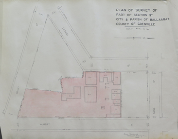
Plan, Plan of Survey of Part of Section 9A City & Parish of Ballarat County of Grenville (Albert Street frontage), 1932
... .1) Plan of SMB showing Albert, Grant, Lydiard and Dana streets, on paper with colored highlights undertaken by Ballarat School of Mines student George Murrowood in 1932 .2) Hand written page by George Murrowood, of technical description of land surveying Grade II 1932...John Trade Building was built on the Albert Street Frontage. ballarat school of mines surveying george murrowood albert street alumni m.b. john building architectural plan .1) Plan of SMB showing Albert, Grant, Lydiard and Dana streets, on paper with colored highlights undertaken by Ballarat School of Mines student George Murrowood in 1932 .2) Hand written page by George Murrowood, of technical description of land surveying Grade II 1932 Plan of Survey of Part of Section 9A City & Parish of Ballarat County of Grenville (Albert Street frontage) Plan Plan George Murrowood ...The M.B. John Trade Building was built on the Albert Street Frontage..1) Plan of SMB showing Albert, Grant, Lydiard and Dana streets, on paper with colored highlights undertaken by Ballarat School of Mines student George Murrowood in 1932 .2) Hand written page by George Murrowood, of technical description of land surveying Grade II 1932ballarat school of mines, surveying, george murrowood, albert street, alumni, m.b. john building, architectural plan -
 Federation University Historical Collection
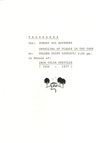
Document - Documents, Golden Point - Mount Pleasant Progress Association Establishment
... Topics include: Pearce's Park; removal of elms, names and addresses of members, Sovereign Hill realignment; Sovereign Hill Lookout; membership form; Golden Point Historic Mines Direction Indicator; Ballarat Observatory; Nerrina Tip; Yarrowee Creek; Mine Capping (Sovereign Mine); tree planting (Sovereign Hill Lookout); Magpie Street Park; Hill Street; Yarrowee Flora Park; Barkly Street; South Street Bluestone Gutter; Ballarat Goldfields; Eastern baths site; Grant Street; Flooding; Aboriginal Advancement League; Sunnyside Woollen Mill; Chinese Garden; Golden Point Primary School closure; Ballarat West Goldfields; Sovereign Hill Land Title and Management Revision; Wainwright; Street; Llanberris; Yuille's Station Park...Topics include: Pearce's Park; removal of elms, names and addresses of members, Sovereign Hill realignment; Sovereign Hill Lookout; membership form; Golden Point Historic Mines Direction Indicator; Ballarat Observatory; Nerrina Tip; Yarrowee Creek; Mine Capping (Sovereign Mine); tree planting (Sovereign Hill Lookout); Magpie Street Park; Hill Street; Yarrowee Flora Park; Barkly Street; South Street Bluestone Gutter; Ballarat Goldfields; Eastern baths site; Grant Street; Flooding; Aboriginal Advancement League; Sunnyside Woollen Mill; Chinese Garden; Golden Point Primary School closure; Ballarat West Goldfields; Sovereign Hill Land Title and Management Revision; Wainwright; Street; Llanberris; Yuille's Station Park Golden Point - Mount Pleasant Progress Association Establishment Document Documents ...The Golden Point - Mt Pleasant Progress Association was established on Wednesday 6 April 1983. Membership was open to any person or organisation in the area generally bounded by Bridge mall and Skipton Street, Elsworth Street and main Road. annual family or organisation membership was $2.00. Mara Gluyas served as secretary of the Golden Point - Mt Pleasant Progress Association from 1983 to 1994. Ian McKinnon was the President from 1983 to 1992. Kerry Daniels was the President in 1994.A small white cardboard box with purple lid of A4 documents relating to the establishment of the Golden Point - Mt Pleasant Progress Association. The documents include the original constitution and minutes. Topics include: Pearce's Park; removal of elms, names and addresses of members, Sovereign Hill realignment; Sovereign Hill Lookout; membership form; Golden Point Historic Mines Direction Indicator; Ballarat Observatory; Nerrina Tip; Yarrowee Creek; Mine Capping (Sovereign Mine); tree planting (Sovereign Hill Lookout); Magpie Street Park; Hill Street; Yarrowee Flora Park; Barkly Street; South Street Bluestone Gutter; Ballarat Goldfields; Eastern baths site; Grant Street; Flooding; Aboriginal Advancement League; Sunnyside Woollen Mill; Chinese Garden; Golden Point Primary School closure; Ballarat West Goldfields; Sovereign Hill Land Title and Management Revision; Wainwright; Street; Llanberris; Yuille's Station Parkgolden point, mount pleasant, mt pleasant, ian mckinnno, mara gluyas, peter hiscock, frank williams, geoff howard, leigh gillett, sovereign hill, kerry daniels, norm strange; graeme kent; george netherway; keith rash; ian mckinnon, albert graham, bryan crebbin, jim humphreys. wid radbourn, heath martin, janet dore, alex mills park -
 Federation University Historical Collection
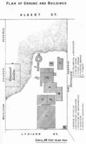
Book - Annual Report 1880, The School of Mines Ballaarat Annual Report, 9 February, 1880, 1880
... The School of Mines Annual Report, 9 February, 1881, Additional Examination Statute 1880, Balance Sheet, Certificates Granted by Council, Donations and Fees - carriage of, Extracts from Visitors' Book, Fees, Form of Bequest, Honorary Correspondents, Life Governors, Mining and Mineral Contributions Invited - Paper of Particulars, Museum - open to visitors, Office Bearers, Obituary, Report of the Lecturer in Mathematics, Report of the Lecturer in Mining-Land- and Engineering-Surveying, Report of the Lecturer in Mechanical Engineering, Report of the Lecturer in Telegraphy, Report of the Curator of the Museum (with Plans), Report of the Superintendent of Laboratories, Subjects and Lecturers, Subjects and Examiners, Statement of Receipts and Expenditure for the year 1880, Subscriptions and Donations from 1 January to 31 December 1880, The Lal-Lal Iron Ore Deposits - (with Section and Plan)...Barker Library (top floor) Mount Helen goldfields The School of Mines Annual Report, 9 February, 1881, Additional Examination Statute 1880, Balance Sheet, Certificates Granted by Council, Donations and Fees - carriage of, Extracts from Visitors' Book, Fees, Form of Bequest, Honorary Correspondents, Life Governors, Mining and Mineral Contributions Invited - Paper of Particulars, Museum - open to visitors, Office Bearers, Obituary, Report of the Lecturer in Mathematics, Report of the Lecturer in Mining-Land- and Engineering-Surveying, Report of the Lecturer in Mechanical Engineering, Report of the Lecturer in Telegraphy, Report of the Curator of the Museum (with Plans), Report of the Superintendent of Laboratories, Subjects and Lecturers, Subjects and Examiners, Statement of Receipts and Expenditure for the year 1880, Subscriptions and Donations from 1 January to 31 December 1880, The Lal-Lal Iron Ore Deposits - (with Section and Plan) the school of mines annual report additional examination statute 1880 balance sheet certificates granted by council donations and fees - carriage of extracts from visitors' book fees form of bequest honorary correspondents life governors mining and mineral contributions invited-paper of particulars museum open to visitors office bearers obituary report of the lecturer in mathematics report of the lecturer in mining-land and engineering-surveying report of the lecturer in mechanical engineering report of the lecturer in telegraphy report of the curator of the museum (with plans) report of the superintendent of laboratories subjects and lecturers subjects and examiners statement of receipts and expenditure for the year 1880 subscriptions and donations from 1 january to 31 december 1880 the lal-lal iron ore deposits-(with section and plan) obituary - sir redmond barry - arthur leahy - jacob upfold - john day mr james oddie dr. r. f. hudson john victor chas. wm. thomas w. h. shaw walter d. campbell ferdinand m. krause joseph flude geo. perry w. hy. barnard examination statute his excellency sir wm. f. drummond jervois charles h. pearson t. brodribb professor pepper james mitchell robert adam wm. lant carperter h. b. de la poer wall w. h. brokenshire arthur parker henry parkinson c. davies simon richards c. v. gorton c. r. blackett david jones wilberforce dyke ferdinand krause ballarat school of mines museum ballarat school of mines museum plan lal lal ore deposits moorabool river William Land Carpenter William jervois William Henry TBarnard Pale green booklet of 70 pages, Annual Report 1880. ...The School of Mines Annual Report, 9 February, 1881, Additional Examination Statute 1880, Balance Sheet, Certificates Granted by Council, Donations and Fees - carriage of, Extracts from Visitors' Book, Fees, Form of Bequest, Honorary Correspondents, Life Governors, Mining and Mineral Contributions Invited - Paper of Particulars, Museum - open to visitors, Office Bearers, Obituary, Report of the Lecturer in Mathematics, Report of the Lecturer in Mining-Land- and Engineering-Surveying, Report of the Lecturer in Mechanical Engineering, Report of the Lecturer in Telegraphy, Report of the Curator of the Museum (with Plans), Report of the Superintendent of Laboratories, Subjects and Lecturers, Subjects and Examiners, Statement of Receipts and Expenditure for the year 1880, Subscriptions and Donations from 1 January to 31 December 1880, The Lal-Lal Iron Ore Deposits - (with Section and Plan)Pale green booklet of 70 pages, Annual Report 1880. Image of Guage Test Tower, Image of The School of Mines, Plan of Ground and Buildings - Albert Street, The School of Mines Ballaarat - The Museum - Plan of Groundfloor, Image of the Lal-Lal Iron Ore Deposits, Moorabool Riverthe school of mines, annual report, additional examination statute 1880, balance sheet, certificates granted by council, donations and fees - carriage of, extracts from visitors' book, fees, form of bequest, honorary correspondents, life governors, mining and mineral contributions invited-paper of particulars, museum open to visitors, office bearers, obituary, report of the lecturer in mathematics, report of the lecturer in mining-land and engineering-surveying, report of the lecturer in mechanical engineering, report of the lecturer in telegraphy, report of the curator of the museum (with plans), report of the superintendent of laboratories, subjects and lecturers, subjects and examiners, statement of receipts and expenditure for the year 1880, subscriptions and donations from 1 january to 31 december 1880, the lal-lal iron ore deposits-(with section and plan), obituary - sir redmond barry - arthur leahy - jacob upfold - john day, mr james oddie, dr. r. f. hudson, john victor, chas. wm. thomas, w. h. shaw, walter d. campbell, ferdinand m. krause, joseph flude, geo. perry, w. hy. barnard, examination statute, his excellency sir wm. f. drummond jervois, charles h. pearson, t. brodribb, professor pepper, james mitchell, robert adam, wm. lant carperter, h. b. de la poer wall, w. h. brokenshire, arthur parker, henry parkinson, c. davies, simon richards, c. v. gorton, c. r. blackett, david jones, wilberforce dyke, ferdinand krause, ballarat school of mines museum, ballarat school of mines museum plan, lal lal ore deposits, moorabool river, william land carpenter, william jervois, william henry tbarnard -
 Federation University Historical Collection
Letter - Correspondence, Inwards correspondence to the Ballarat School of Mines, 1908, 07/01908
... land surveying...j. brittain...g. fitzgerald...hamilton...cochran and co...wynne-grant...It is a predecessor institution of Federation University Australia. ballarat school of mines frederick martell ballarat fine art gallery j.a. powell art gallery of ballarat gallery association charles j. morris ballarat fine art public gallery association telegram c.h. clark l. ditchburn alumni examinations w.g. taylor london bank of australia limited bealiba thomas r. lyle jessie chalmers signor steffani arundel orchard w.f. coltman e.e. hobson j.t. mooney queanbeyan p.e. marmion willaim m. robertson assay e.e. brook lloyd copper mines h.b. silberberg & co. education department melbourne c. james w. west haddon warragul bakers reef gold mning company letterhead victorian portland cement works d. mitchell electric lighting and traction co. australia ltd austral otis engineering comapny ltd melbourne glass bottle works company cuming, smith & co. pty ltd excursions metropolitan gas company jaques bros manufacturing engineers victoria iron works a. victor leggo co leggo's metallurgical works melbourne hydraulic power company limited mount lyell mining and railway coy ltd victorian railways telegraph land surveying j. brittain g. fitzgerald hamilton cochran and co wynne-grant antimony reduction company mt egerton and gordons mining co e. hogan e.c. connell a.d. galoway metallurgy h.b. silberberg Specific Gravity Balance and Weights Union Bank of Australia (Ballarat) Bullarto Bush Inn, Bullarto W. ...The Ballarat School of Mines was the first school of Mines in Australasia, and was established in 1870. It is a predecessor institution of Federation University Australia.Correspondence to the Ballarat School of Mines for the month of July 1908. Letter 162 Ballarat Fine Art Public Gallery Association 19 Lydiard Street North Ballarat, 26th June 1908 Sir, I am directed to inform you that at a meeting of the Council of the above held last evening, your previously acknowledged letter of 11th June 1908, addressted to "E. [Stoer?] Esq, President Late Technical Art School Committee", was received and referred to a committee for its report thereon, cousi directions of which was made are the Order of the Day for the Councils next Ordinary Monthly Meeting. I am, Sir, Your Obedient Servant, J.A. Powell Secretary F.J. Martell Esq Director The Ballarat School of Mines Ballarat ballarat school of mines, frederick martell, ballarat fine art gallery, j.a. powell, art gallery of ballarat, gallery association, charles j. morris, ballarat fine art public gallery association, telegram, c.h. clark, l. ditchburn, alumni, examinations, w.g. taylor, london bank of australia limited, bealiba, thomas r. lyle, jessie chalmers, signor steffani, arundel orchard, w.f. coltman, e.e. hobson, j.t. mooney, queanbeyan, p.e. marmion, willaim m. robertson, assay, e.e. brook, lloyd copper mines, h.b. silberberg & co., education department melbourne, c. james, w. west, haddon, warragul, bakers reef gold mning company, letterhead, victorian portland cement works, d. mitchell, electric lighting and traction co. australia ltd, austral otis engineering comapny ltd, melbourne glass bottle works company, cuming, smith & co. pty ltd, excursions, metropolitan gas company, jaques bros manufacturing engineers, victoria iron works, a. victor leggo co, leggo's metallurgical works, melbourne hydraulic power company limited, mount lyell mining and railway coy ltd, victorian railways, telegraph, land surveying, j. brittain, g. fitzgerald, hamilton, cochran and co, wynne-grant antimony reduction company, mt egerton and gordons mining co, e. hogan, e.c. connell, a.d. galoway, metallurgy, h.b. silberberg, specific gravity balance and weights, union bank of australia (ballarat), bullarto, bush inn, bullarto, w. harrington, prospective student, book donaton from smithsonian institution, e. la t. armstrong, department of mines and forests, melbourne, snake valley, r. hall-jones, c. calaby, clementston, thomas ramsay, w.d. thompson, longmans, green and co, selwyn chase, missionary exhibition, aboriginal court of the missionary exhibition, examination results, leslie coulter, hnery j. saw, thomas ramsay, virgil tucker, leslie c. blick, thomas r. williams, oliver w. williams, thomas r. williams, leo m. seward, david w. bonar, louis w.g. buchner, leo m. seward, albert j. robin, james a. chambers, james d. brokenshire, william kingston, edgar c. hurdsfield, virgil tucker, oliver w. williams, william g. sides, herbert hawkesworth, colin c. corrie, henry j. saw, thomas h. trengrove, thomas r. prigdeon, harold b. herbert, viola p. jackson, lionel s. davies, stanley w. tompkins, arthur m. lilburne -
 Federation University Historical Collection
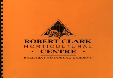
Booklet, Robert Clark Horticultural Centre: Ballarat Botanical Gardens, c1993
... "The 250 acres of land to the west of Yuilles Swamp (Lake Wendouree) was permanently granted to The Corporation of the City of Ballaarat by the State Government on the 23rd December 1857 for the purposes of a 'Botanical Garden for the recreation, education and enjoyment of the community." ...Barker Library (top floor) Mount Helen goldfields "The 250 acres of land to the west of Yuilles Swamp (Lake Wendouree) was permanently granted to The Corporation of the City of Ballaarat by the State Government on the 23rd December 1857 for the purposes of a 'Botanical Garden for the recreation, education and enjoyment of the community." ..."The 250 acres of land to the west of Yuilles Swamp (Lake Wendouree) was permanently granted to The Corporation of the City of Ballaarat by the State Government on the 23rd December 1857 for the purposes of a 'Botanical Garden for the recreation, education and enjoyment of the community." The Robert Clark Horticultural Centre was opened in 1995.Large format spiral bound booklet with yellow cover. Bordered pages with writing or coloured photographsyuilles swamp, lake wendouree, corporation of the city of ballaarat, botanical gardens, recreation, education, horticulture, robert clark, ballarat botanical gardens, robert clark centre, robert clark horticultural centre -
 Narre Warren and District Family History Group
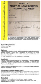
CD, W.A. Genealogical Society, Inc, Convict ticket-of-leave register, Toodyay Acc. 721/30, 2004
... land. At the end of their sentences, ex-convicts or 'expirees' were given their freedom, although those with life or long-term sentences were often granted Conditional Pardons, which conferred most of the benefits of freedom but did not allow them to return to England. ...Convict ticket-of-leave register, Toodyay Acc. 721/30 The Swan River Colony, founded in 1829, as a free settlement needed an injection of capital and an increase in population if it was to thrive. In late 1849 a petition signed by prominent settlers, requesting that male convicts be sent to the Swan River, was submitted to the colonial office. This request was welcomed and transportation officially began to Western Australia in 1850. The first convict ship, the Scindian, arrived at Fremantle on June 1 carrying 75 convicts and a small group of Enrolled Pensioner Guards and their families. Eighteen years later the last convict transport, the Hougoumont, arrived with 280 convicts, mostly Irish political prisoners, making a total of nearly 10,000 convicts arriving in the colony. This availability of cheap labour resulted in many convicts being granted their 'ticket-of-leave' before their sentences had expired, which allowed private settlers to employ them. To facilitate the distribution of working men throughout the settlement, hiring depots were established in key town and country areas. Ticket-of-leave men could not leave their assigned district without permission; had to carry their 'ticket' with them at all times and produce it to any official on demand; as well as lodge an official form with the local magistrate on January 1 and July 1 every year which detailed residence, employer and rate of pay. On the positive side, ticket of leave men were able to choose their own employer and even work for themselves. They could also marry with permission of the authorities and even own land. At the end of their sentences, ex-convicts or 'expirees' were given their freedom, although those with life or long-term sentences were often granted Conditional Pardons, which conferred most of the benefits of freedom but did not allow them to return to England. The movement of convicts around the colony is preserved in the many surviving convict registers which are now kept in the State Records Office of WA . These registers list the names of employers and the dates convicts were employed, and detail the rates of pay and any brushes the convict had with authorities. Many of the employers were themselves 'ticket-of-leave' men, expirees or conditional pardon men. One of the convict hiring depots was at Toodyay and two registers from this institution for the period 1862 to 1870 have been archived in the State Records Office at Accession Number 721, volumes 30 and 31. The impact these men had on the infant colony can best be guessed from the statistical data available from official records. In 1850 there were only 5,000 residents in the colony, but at the end of the convict period the number had risen to 25,000. While some convicts emigrated to other parts of Australia after receiving their conditional pardons, the majority stayed in Western Australia. Some had their families join them from the United Kingdom, while others married the young women who came out on the 'Bride Ships'. Over the years family historians' research into their forebears' convict origins have shown the profound influence these men have had on the development of the State of Western Australia and the districts in which they worked, settled and raised their families.1 optical discnon-fictionConvict ticket-of-leave register, Toodyay Acc. 721/30 The Swan River Colony, founded in 1829, as a free settlement needed an injection of capital and an increase in population if it was to thrive. In late 1849 a petition signed by prominent settlers, requesting that male convicts be sent to the Swan River, was submitted to the colonial office. This request was welcomed and transportation officially began to Western Australia in 1850. The first convict ship, the Scindian, arrived at Fremantle on June 1 carrying 75 convicts and a small group of Enrolled Pensioner Guards and their families. Eighteen years later the last convict transport, the Hougoumont, arrived with 280 convicts, mostly Irish political prisoners, making a total of nearly 10,000 convicts arriving in the colony. This availability of cheap labour resulted in many convicts being granted their 'ticket-of-leave' before their sentences had expired, which allowed private settlers to employ them. To facilitate the distribution of working men throughout the settlement, hiring depots were established in key town and country areas. Ticket-of-leave men could not leave their assigned district without permission; had to carry their 'ticket' with them at all times and produce it to any official on demand; as well as lodge an official form with the local magistrate on January 1 and July 1 every year which detailed residence, employer and rate of pay. On the positive side, ticket of leave men were able to choose their own employer and even work for themselves. They could also marry with permission of the authorities and even own land. At the end of their sentences, ex-convicts or 'expirees' were given their freedom, although those with life or long-term sentences were often granted Conditional Pardons, which conferred most of the benefits of freedom but did not allow them to return to England. The movement of convicts around the colony is preserved in the many surviving convict registers which are now kept in the State Records Office of WA . These registers list the names of employers and the dates convicts were employed, and detail the rates of pay and any brushes the convict had with authorities. Many of the employers were themselves 'ticket-of-leave' men, expirees or conditional pardon men. One of the convict hiring depots was at Toodyay and two registers from this institution for the period 1862 to 1870 have been archived in the State Records Office at Accession Number 721, volumes 30 and 31. The impact these men had on the infant colony can best be guessed from the statistical data available from official records. In 1850 there were only 5,000 residents in the colony, but at the end of the convict period the number had risen to 25,000. While some convicts emigrated to other parts of Australia after receiving their conditional pardons, the majority stayed in Western Australia. Some had their families join them from the United Kingdom, while others married the young women who came out on the 'Bride Ships'. Over the years family historians' research into their forebears' convict origins have shown the profound influence these men have had on the development of the State of Western Australia and the districts in which they worked, settled and raised their families.western australia, convicts western australia, toodyay registers -
 Ballarat Tramway Museum
Map, Electric Supply Co. of Vic (ESCo), Ballarat Electoral Map - ESCo, 1900
... granted to company. Dated 19/2/1901 and signed by the Postmaster-General. Shows the order area being parts of the City of Ballaarat, Sebastopol and Ballarat East. Shows the street names, boundaries, principal power line routes, land...granted to company. Dated 19/2/1901 and signed by the Postmaster-General. Shows the order area being parts of the City of Ballaarat, Sebastopol and Ballarat East. Shows the street names, boundaries, principal power line routes, land ...Document prepared by the Electric Supply Co of Victoria, as part of an order under the Electric Light and Power Act 1896, section 5 of order No. 17 granted to company. Dated 19/2/1901 and signed by the Postmaster-General. Shows the order area being parts of the City of Ballaarat, Sebastopol and Ballarat East. Shows the street names, boundaries, principal power line routes, land reserves, parks, mine locations, railways and Lake Wendouree. Signed by R L Williams Town Clerk City of Ballarat, J R Hall for the Borough of Sebastopol, and John Gent for the Town of Ballarat EastYields information about the power supply to the Ballarat area.Cloth backed paper map, coloured and marked up as exhibit 17.Notes in ink including the signature of Benjamin Deakin 24/9/00 and certified by the three involved municipal Town Clerks.ballarat power supply, esco, electric supply co of victoria, city of ballaarat, east ballarat, sebastopol, orders, power lines, power supply -
 Ringwood and District Historical Society
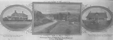
Flyer, Strip of images used for Ringwood Heights Estate land sale promotion - 1924
... Land on left of road and down to Mullum Creek. Sold by T. Grant. 97 lots, 1st March 1924. ...Land on left of road and down to Mullum Creek. Sold by T. Grant. 97 lots, 1st March 1924. ...Strip of 3 views apparently part of a land sale advertisement.(2 copies)Typed on rear of photographs: "Ringwood Heights Estate. Land on left of road and down to Mullum Creek. Sold by T. Grant. 97 lots, 1st March 1924. J.B. McAlpin, agent. No deposit, £1 per month." -
 Vision Australia
Administrative record - Text, Royal Victorian Institute for the Blind annual report 1928, 1928
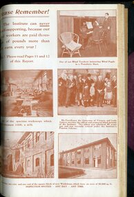
... Finlayson, to perpetuate the loss of Lady Brunton (a vocal supporter of the Institute) her husband Lord Brunton invested 350 pounds for the purpose of establishing the "Lady Brunton Memorial Prize Fund for Educational Purposes", a Girl Guide and Brownie troop were formed during the year, George Findlay received his degree in Music, many pupils completed their Pianoforte examination at the University Conservatorium with Honours, over 14,000 people attended Concert Party performances in Ballarat and Bendigo and nearly 3000 people packed into Melbourne Town Hall, thanks to the Advance Agent (R Reid), Manager (Alf Broadway) and volunteer Stage Manager (W Sewell) who helped our artists put together their momentous events, piano tuners continue to see a demand for their services under the skilled tuition of Alex Johnson, request for amended legislation so that people can train as masseurs, a hostel for males will be completed in a few months time and the womens hostel is proving invaluable to young women and female adult workers, free Wireless Sets distributed have had their licences renewed and batteries replaced with many letters of appreciation coming in from families who have seen a world of change for those who can now listen to the wider world, grant of two acres of land for use as a sporting ground by the St Kilda Council, new rowing shed and club house to be built at Albert Park so that all blind people can avail themselves of this pastime, visiting cricket teams from New South Wales and Adelaide at a social evening, continued work with homecraft workers, concert in Ormond Hall for Tramways Board and employees to thank them for free passes and the passing of pupil Mavis Thompson....Finlayson, to perpetuate the loss of Lady Brunton (a vocal supporter of the Institute) her husband Lord Brunton invested 350 pounds for the purpose of establishing the "Lady Brunton Memorial Prize Fund for Educational Purposes", a Girl Guide and Brownie troop were formed during the year, George Findlay received his degree in Music, many pupils completed their Pianoforte examination at the University Conservatorium with Honours, over 14,000 people attended Concert Party performances in Ballarat and Bendigo and nearly 3000 people packed into Melbourne Town Hall, thanks to the Advance Agent (R Reid), Manager (Alf Broadway) and volunteer Stage Manager (W Sewell) who helped our artists put together their momentous events, piano tuners continue to see a demand for their services under the skilled tuition of Alex Johnson, request for amended legislation so that people can train as masseurs, a hostel for males will be completed in a few months time and the womens hostel is proving invaluable to young women and female adult workers, free Wireless Sets distributed have had their licences renewed and batteries replaced with many letters of appreciation coming in from families who have seen a world of change for those who can now listen to the wider world, grant of two acres of land for use as a sporting ground by the St Kilda Council, new rowing shed and club house to be built at Albert Park so that all blind people can avail themselves of this pastime, visiting cricket teams from New South Wales and Adelaide at a social evening, continued work with homecraft workers, concert in Ormond Hall for Tramways Board and employees to thank them for free passes and the passing of pupil Mavis Thompson. ...Articles in this annual report include: dismay at continued amount of Government financial support has been capped for over 30 years despite increased costs, visits by Lady Stonehave, Lord and Lady Somers, the reduction in sale prices due to overwhelming competition with machinery made goods, resignation of M.A. Tanswell and appointment of H.E. Finlayson, to perpetuate the loss of Lady Brunton (a vocal supporter of the Institute) her husband Lord Brunton invested 350 pounds for the purpose of establishing the "Lady Brunton Memorial Prize Fund for Educational Purposes", a Girl Guide and Brownie troop were formed during the year, George Findlay received his degree in Music, many pupils completed their Pianoforte examination at the University Conservatorium with Honours, over 14,000 people attended Concert Party performances in Ballarat and Bendigo and nearly 3000 people packed into Melbourne Town Hall, thanks to the Advance Agent (R Reid), Manager (Alf Broadway) and volunteer Stage Manager (W Sewell) who helped our artists put together their momentous events, piano tuners continue to see a demand for their services under the skilled tuition of Alex Johnson, request for amended legislation so that people can train as masseurs, a hostel for males will be completed in a few months time and the womens hostel is proving invaluable to young women and female adult workers, free Wireless Sets distributed have had their licences renewed and batteries replaced with many letters of appreciation coming in from families who have seen a world of change for those who can now listen to the wider world, grant of two acres of land for use as a sporting ground by the St Kilda Council, new rowing shed and club house to be built at Albert Park so that all blind people can avail themselves of this pastime, visiting cricket teams from New South Wales and Adelaide at a social evening, continued work with homecraft workers, concert in Ormond Hall for Tramways Board and employees to thank them for free passes and the passing of pupil Mavis Thompson.1 volume bound with illustrations.royal victorian institute for the blind, annual report, j tanswell, harry finlayson, lady brunton, lord brunton, girl guides, brownies, george findlay, r reid, alf broadway, w sewell, alex johnson, raleigh street hostel, rowing, cricket, mavis thompson -
 Ringwood and District Historical Society
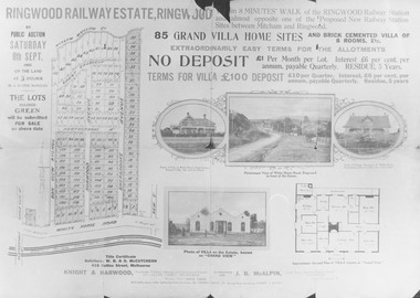
Flyer, Land Sale Brochure, Ringwood Railway Estate, Ringwood. 1923
... Grant Crescent. For additional details of the Ringwood Railway Estate, Ringwood see VC5183. Black and white copy of printed brochure advertising 85 Residential Lots for sale by Public Auction, Saturday, 8th September, 1923. Land ...Black and white copy of printed brochure advertising 85 Residential Lots for sale by Public Auction, Saturday, 8th September, 1923.Subdivision includes Bon View Avenue, Burwood Avenue, Sherbrooke Avenue, Heatherbrae Avenue, Grant Crescent. For additional details of the Ringwood Railway Estate, Ringwood see VC5183. -
 Wangaratta RSL Sub Branch
Photograph, c1940
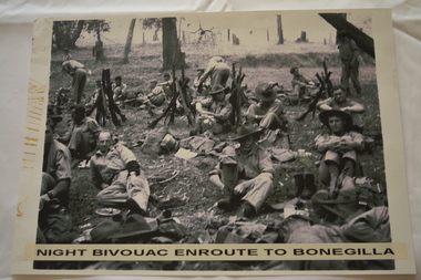
... The Unit was granted the Freedom of the City by the Rural City of Wangaratta in 1990 and one of the first, if not the first, to receive this type of honour. 2/24th battalion wangaratta Night bivouac enroute to Bonegilla Reproduced black and white photograph of unknown soldiers sitting on the ground in bush land. ...In July 1940, the 2/24th Battalion was formed in Wangaratta. On the 27th September, after weeks of hard training the Battalion marched out to Bonegilla to continue training prior to overseas deployment to the Middle East in November, 1940. This image depicts soldiers resting during the 60 mile march.The 2/24th Battalion was an infantry battalion of the Australian Army, which served during World War II .A unit of all-volunteers, it was formed in July 1940 from primarily Victorian volunteers and was known as "Wangaratta's Own" because of the time the battalion spent in the town during its formative period prior to deployment overseas. It served in North Africa in 1941–1942 as part of the 26th Brigade, which was assigned to the 7th Division, before being reassigned to the 9th Division. In early 1943, the battalion returned to Australia and later took part in campaigns against the Japanese in New Guinea in 1943–1944 and Borneo in 1945, before being disbanded in 1946. The 2/24th suffered the highest number of casualties of any 2nd AIF infantry battalion. The Unit was granted the Freedom of the City by the Rural City of Wangaratta in 1990 and one of the first, if not the first, to receive this type of honour.Reproduced black and white photograph of unknown soldiers sitting on the ground in bush land. Night bivouac enroute to Bonegilla2/24th battalion, wangaratta -
 Merri-bek City Council
Painting - Oil on linen, Renee Cosgrave, Learning Whakapapa (Māori Land Court Archives), 2023
... land and waters, and specifically draw from sites of personal significance to her whānau/family. Cosgrave also references her engagement in learning about her Whakapapa (genealogy) through the title of the work, which acts as a reminder of her ongoing engagement with her culture. Artist biography Renee Cosgrave (b. 1986) lives and works in Naarm/Melbourne on Wurundjeri Woi-wurrung Country. She’s from Aotearoa/New Zealand of Irish, Māori (Ngāti Tūwharetoa iwi) and Scottish ancestry. Renee’s practice explores abstract painting and speaks to concepts of whakapapa (genealogy). Renee was awarded the MECCA M-Power National Gallery of Victoria Arts Mentoring Grant ... -
 City of Melbourne Libraries
Photograph, Bull, Hugh Jones, 1897-1993, Vice-regal visit to zoo: Governor (Lord Huntingfield) meets the cockatoos
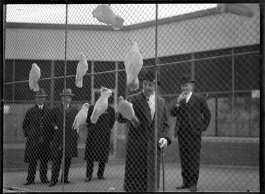
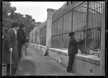
... The Victorian Government granted 32 acres (13 hectares) of land to the Zoological Society at the southern end of Richmond Paddock on the opposite bank to the Botanical Gardens. ...The Victorian Government granted 32 acres (13 hectares) of land to the Zoological Society at the southern end of Richmond Paddock on the opposite bank to the Botanical Gardens. ...A group of five men dressed in hats and overcoats look at caged cockatoos. Research by project volunteer, Fiona Collyer: On 25 June 1934, new Victorian Governor, His Excellency Lord Huntingfield and his wife Lady Huntingfield made an official visit to the Melbourne Zoological Gardens in order to grant his patronage to the Royal Zoological and Acclimatisation Society. The zoo director, Mr. Andrew Wilkie, introduced them to the cockatoos in the flight aviary. The Argus newspaper reported the visit in the following morning’s issue: "Birds' Greeting To Governor. Visit to Zoological Gardens. "A Very Important Society." "Cheery shouts of "Hullo!" and requests for drinks greeted His Excellency the Governor (Lord Huntingfield) on one of his official visits yesterday morning. Lady Huntingfield, who accompanied him, was asked loudly for a kiss. They were inspecting the huge cockatoo aviary at the Zoological Gardens after Lord Huntingfield had granted his patronage to the Royal Zoological and Acclimatisation Society. Both obviously enjoyed the democratic experience. It was explained to them that most of the cockatoos had been presented by residents of flats, whose neighbours objected to the noise of the birds, while others were protected birds which had been surrendered. Lord Huntingfield recalled that he had taken two Australian cockatoos to England when he left Australia in his youth. One, a galah, had lived in England for many years." In 1929, the Zoo built a commodious new flight aviary at the cost of several thousand pounds and Zoo director, Mr Andrew Wilkie, sent out an appeal published in newspapers Australia-wide for donations of parrots from all states. Many of the parrot species he wanted were protected and a special permit needed for their capture, however Mr Wilkie guaranteed he would obtain authority from the Fisheries and Game Department and that the cost of transit would be borne by the Zoo. The wanted birds were "Parrots - Black-tailed, Rock Pebbler, King, Superb, Grass (all kinds), Swamp or Ground, Mallee or Ringneck" and "Cockatoo[s] - Black, Pink or Major Mitchell, Gang-Gang". The Zoo asked that the birds be sent in boxes large enough to prevent overcrowding, contain food and water and the Zoo notified on the type and number of birds in transit. All boxes were to be addressed to 'The Zoo, Melbourne'. A letter from a reader appeared in the Weekly Times newspaper's popular "Camp-fire Circle" page for "Young Australians", 11 May 1929: "Dear Pal, I am much interested in your page, especially the nature notes. I have a pet parrot, but I don’t like to see it shut up in a cage, so I am giving it to the Melbourne Zoo. It can whistle 'Pretty Joey' and 'What's the Matter with Father' and is just learning to whistle for the dog... Wishing you and the Camp-fire Circle success." - Murray Holmes (Gorae, Vic.) The fate of this talented parrot is unknown, however in 1932, this young naturist, T Murray Holmes, 1912-1947, collected for the first time a type specimen, blue star sun orchid from Gorae (near Portland, Victoria), and it was named in his honour, Thelymitra holmesii. Murray was described by orchid collector W H Nicholls as "a youthful and energetic orchidologist, who added much to our knowledge of the orchids of south-western Victoria." Murray Holmes enlisted in the army in 1941 and fought in the Middle East before being sent to Java. In 1942 he was captured by the Japanese and became a prisoner of war for three years, working on the notorious Thai-Burma railway. Murray's health was undermined though ill treatment and starvation and he returned to Australia after the war, broken and sick. He died aged 35 in 1947. He was intensely interested in the flora and fauna of the Gorae area to the end. Murray's parents received over 200 tributes of respect for their son - too many to answer personally so they put a notice in the Portland Guardian thanking "all kind friends and relatives for letters, cards, floral tributes and personal expressions of sympathy received in their recent sad bereavement - the lamented death of their loved son, Murray." Andrew Arthur Wellesley Wilkie, 1853-1948, was Director of the Melbourne Zoo from 1923 to 1936 and was associated with the zoo for 70 years. He first worked as a horticultural assistant to Government botanist Baron Ferdinand von Mueller at the Botanical Gardens at the age of 13, along with his older brother David. One of Andrew’s jobs was to capture moths for the National Herbarium. In 1857, a group of prominent Melburnians assembled at St. Patrick’s Hall to form the Zoological Society of Victoria, with the aim of introducing animals and plants from overseas. It was conceived, “For the purposes of science and for that of affording the public the advantages of studying the habits of the animal creation in properly arranged zoological gardens.” The Victorian Government granted 32 acres (13 hectares) of land to the Zoological Society at the southern end of Richmond Paddock on the opposite bank to the Botanical Gardens. (This is where AAMI Stadium and Collingwood Football Club now stand.) In 1861, the Zoological Society of Victoria was renamed The Acclimatisation Society of Victoria. Unfortunately the Yarra River frontage was damp, swampy and subject to flooding, so the animals were briefly housed at the Botanical Gardens until in 1862, the City of Melbourne donated 55 acres (22 hectares) of land at Royal Park for the fledgling zoo. Baron von Mueller secured employment at Royal Park for Andrew and David and they helped to lay out the gardens, plant trees and take care of a collection of deer, pheasants, hares and partridges. Initially the zoo was used for the acclimatisation of animals recovering from the long voyage to Australia and for breeding them for sport. In 1872, the zoo bought two lions, a leopard and a cheetah that had been seized from circus showmen Keith and Phillips when they were unable to pay the bill of butcher Mr T K Bennet of Bourke Street. The first zoo director, Mr. Albert Le Souef, negotiated with captains of ships to buy animals at overseas ports they visited and soon a multitude of exotic species arrived, including a ten-year-old Indian elephant in 1878. In 1923, after being head keeper for some years, Andrew was appointed director of the zoo. By 1933, the zoo had 110 different species of animals, 200 species of birds and 72 species of reptiles under Andrew’s care. He had personally planted all but six trees and laid out the garden beds. As director he lobbied authorities for funds to build more humane enclosures for the animals. In June 1928, Table Talk magazine wrote of Andrew Wilkie: “Up at the Zoo there is a humble gentleman who is a lion among the lions, who knows the proper specific to employ when the boa constrictor has chilblains, and who is a friend and confidant of Queenie the elephant. His fount of zoological lore has never been plumbed. It is bottomless, like his good fellowship and geniality. Every day he may be seen somewhere in the grounds of that growing sanctuary for the strange and arresting fauna and creeping things of the world, and I assure you as one who is privy to his passion that that area and its inhabitants are rarely out of his thoughts.” Andrew retired from the zoo in 1936 at the age of 83 and in 1948 died at his home in Brunswick aged 94. He and his wife Josephine had six children. The Victorian Acclimatisation Society was founded in 1861 by Edward Wilson, 1813-1878, then owner and editor of The Argus newspaper. He said that Australian indigenous animals were practically useless, providing only “a little sport and an occasional meal”. The Society believed that Australia’s plants and animals were vastly inferior to those in Europe. They wanted to introduce and acclimatise to Victoria “all innoxious animals, birds, fishes, insects and vegetables, whether useful or ornamental” for sport and for the table, and to spread indigenous animals and plants from the colony around the world. Their motto was “if it lives, we want it”. The Society was primarily responsible for introducing sparrows, starlings, sambar and hog deer, ostriches, brown trout, blackberries, and carp to the Murray River. They released the European songbirds, thrush and blackbird to quell the homesickness of British settlers. The Society also sent Australian animals like platypus, echidnas, kangaroos and koalas to Europe for scientific and novelty purposes. Thomas Austin, a wealthy sheep farmer of Barwon Park, Winchelsea (property now owned by the National Trust) was a member and in 1859 he introduced hares, blackbirds, thrushes and partridges onto his property. He is probably best known for introducing 24 breeding rabbits onto his estate as game for shooting parties. Thomas quipped, “The introduction of a few rabbits could do little harm and might provide a touch of home, in addition to a spot of hunting." In 2022, genomic data confirmed that Australia’s feral rabbit population is entirely descended from these rabbits. Biological control has brought the rabbit population down from an estimated high of 10 billion rabbits in the 1920s to approximately 200 million today, inhabiting 70% of Australian landmass (5.3 million square kilometres). In 1872, the Acclimatisation Society was renamed The Zoological and Acclimatisation Society of Victoria and they focused on importing exotic animals for display purposes to the zoo. In 1937, the Royal Acclimatisation Society of Victoria was recreated as the Zoological Board of Victoria with a focus on research of native animals threatened with extinction. In an editorial for The Argus newspaper, 16 March 1856, Edward Wilson lamented: "...this country has been shamelessly stolen from the blacks. Had they been like the New Zealanders or the North American Indians, we should have bought their land, and supplied them with the means of living when we took it... In less than twenty years we have nearly swept them off the face of the earth. We have shot them down like dogs. In the guise of friendship we have issued corrosion sublimate in their damper, and consigned whole tribes to the agonies of an excruciating death. We have made them drunkards, and infected them with disease which has rotted the bones of their adults, and made such few children as are born amongst them a sorrow and a torture from the very instant of their birth. We have made them outcasts on their own land, and are rapidly consigning them to entire annihilation. There are but a few of them left, comparatively. This is what we would do for that few. We would feed and clothe every one of them.” [Note: this last sentence is italicized in the original newspaper article text]. Lord Huntingfield, (William Charles Arcedeckne Vanneck) 1883-1969, Governor of Victoria 1934-1939, was a British Conservative Party politician and the first ever Australian-born Governor of an Australian state (although he was always considered British). He was patron of the Royal Zoological and Acclimatisation Society of Victoria and was acting Governor-General for six months during the absence of Lord Gowie in 1938. Lady Huntingfield (née Margaret Eleanor Crosby) 1884-1943, his American-born wife showed great interest in social welfare and the advancement of women and children. She was president of the City Newsboys Society and Patroness of the Girls Friendly Society. In 1937, rose breeder Alister Clark named a yellow hybrid tea rose for her. In 1940, the City of Melbourne opened the Lady Huntingfield Free Kindergarten in North Melbourne, now the Lady Huntingfield Early Learning and Family Services Centre. Lady Huntingfield died in London in 1943 after her house was bombed during a German airstrike. The Lady Huntingfield Memorial Scholarship was established after the City of Melbourne raised £1000 in a public appeal conducted in her memory for students undertaking a Social Work degree at the University of Melbourne. It is awarded annually to this day. The Queen Victoria Hospital named a bed in her honour. References: Prominent Personalities ANDREW WILKIE (1928, June 7). Table Talk (Melbourne, Vic. : 1885 - 1939), p. 15. Retrieved August 29, 2024, from http://nla.gov.au/nla.news-article146562949 BIRDS' GREETING TO GOVERNOR (1934, June 26). The Argus (Melbourne, Vic. : 1848 - 1957), p. 6. Retrieved August 19, 2024, from http://nla.gov.au/nla.news-article10950051 Zoo Appealing For Parrots And Cockatoos To Fill Aviary For Children’s Instruction (1929, April 11). The Sun News-Pictorial (Melbourne, Vic. : 1922 - 1954; 1956), p. 31. Retrieved August 23, 2024, from http://nla.gov.au/nla.news-article275757361 LETTERS FROM READERS (1929, May 11). Weekly Times (Melbourne, Vic. : 1869 - 1954), p. 50. Retrieved October 6, 2024, from http://nla.gov.au/nla.news-article223183144 Correspondence. (1929, April 18). Corryong Courier (Vic. : 1894 - 1945), p. 6. Retrieved August 30, 2024, from http://nla.gov.au/nla.news-article269039262 'Edward Wilson (journalist)', Wikipedia, https://en.wikipedia.org/wiki/Edward_Wilson_(journalist) 'Thomas Austin (pastoralist)', Wikipedia, https://en.wikipedia.org/wiki/Thomas_Austin_(pastoralist) 'The Acclimatisation Society was driven by misguided ideals about 'fixing nature' in Australia', ABC News, https://www.abc.net.au/news/2022-11-04/acclimatisation-society-introduced-species-history-listen/101588262? utm_source=abc_news_app&utm_medium=content_shared&utm_campaign=abc_news_app&utm_content=safari Touching Canine Devotion. (1942, September 21). Portland Guardian (Vic. : 1876 - 1953), p. 1 (EVENING). Retrieved October 6, 2024, from http://nla.gov.au/nla.news-article64381989 OBITUARY (1947, August 11). Portland Guardian (Vic. : 1876 - 1953), p. 2 (EVENING). Retrieved August 26, 2024, from http://nla.gov.au/nla.news-article64412155 Family Notices (1947, September 11). Portland Guardian (Vic. : 1876 - 1953), p. 2 (EVENING). Retrieved October 10, 2024, from http://nla.gov.au/nla.news-article64412476 'Thelymitra holmesii', Wikipedia, https://en.wikipedia.org/wiki/Thelymitra_holmesii THE ABORIGINES. (1856, March 16). The Argus (Melbourne, Vic. : 1848 - 1957), p. 4. Retrieved September 28, 2024, from http://nla.gov.au/nla.news-article4833244Photographer notations on slide: "Vice Regal visit to zoo B42".zoos, governors, 1930-1939, cockatoos -
 City of Melbourne Libraries
Photograph, Bull, Hugh Jones, 1897-1993, Vice-regal visit to Zoo: Lord Huntingfield greets the King of the Beasts
... The Victorian Government granted 32 acres (13 hectares) of land to the Zoological Society at the southern end of Richmond Paddock on the opposite bank to the Botanical Gardens. ...The Victorian Government granted 32 acres (13 hectares) of land to the Zoological Society at the southern end of Richmond Paddock on the opposite bank to the Botanical Gardens. ...Photographer notations on slide: "Vice Regal visit to zoo B42" Published: The Age, Tuesday 26 June 1934, page 11. Published title: VICE-ROYALTY GREETS THE KING OF THE BEASTS AT THE ZOO. Published caption: “Lord Huntingfield experienced a pleasant “induction ceremony” as Patron of the Royal Zoological and Acclimatisation Society yesterday, when he made a tour of the Zoological Gardens. The picture shows the Governor, accompanied by Lady Huntingfield, inspecting the King of the Beasts, who is submitting to a little playful treatment from the Director of the Gardens, Mr. Wilkie, while the Director whispers in his ear that a distinguished visitor has come to see him.” Trove article identifier: http://nla.gov.au/nla.news-article204818472 Description: A man wearing a hat and suit strokes a caged lion, observed by a man in a hat, scarf and overcoat who is leaning on a walking stick, and a woman in a hat and coat, holding a handbag. They stand behind a protective rail. Research by project volunteer, Fiona Collyer: Andrew Arthur Wellesley Wilkie, 1853-1948, was Director of the Melbourne Zoo from 1923 to 1936 and was associated with the zoo for 70 years. He first worked as a horticultural assistant to Government botanist Baron Ferdinand von Mueller at the Botanical Gardens at the age of 13, along with his older brother David. One of Andrew’s jobs was to capture moths for the National Herbarium. In 1857, a group of prominent Melburnians assembled at St. Patrick’s Hall to form the Zoological Society of Victoria, with the aim of introducing animals and plants from overseas. It was conceived, “For the purposes of science and for that of affording the public the advantages of studying the habits of the animal creation in properly arranged zoological gardens.” The Victorian Government granted 32 acres (13 hectares) of land to the Zoological Society at the southern end of Richmond Paddock on the opposite bank to the Botanical Gardens. (This is where AAMI Stadium and Collingwood Football Club now stand.) In 1861, the Zoological Society of Victoria was renamed The Acclimatisation Society of Victoria. Unfortunately the Yarra River frontage was damp, swampy and subject to flooding, so the animals were briefly housed at the Botanical Gardens until in 1862, the City of Melbourne donated 55 acres (22 hectares) of land at Royal Park for the fledgling zoo. Baron von Mueller secured employment at Royal Park for Andrew and David and they helped to lay out the gardens, plant trees and take care of a collection of deer, pheasants, hares and partridges. Initially the zoo was used for the acclimatisation of animals recovering from the long voyage to Australia and for breeding them for sport. In 1872, the zoo bought two lions, a leopard and a cheetah that had been seized from circus showmen Keith and Phillips when they were unable to pay the bill of butcher Mr T K Bennet of Bourke Street. The first zoo director, Mr. Albert Le Souef, negotiated with captains of ships to buy animals at overseas ports they visited and soon a multitude of exotic species arrived, including a ten-year-old Indian elephant in 1878. In 1923, after being head keeper for some years, Andrew was appointed director of the zoo. By 1933, the zoo had 110 different species of animals, 200 species of birds and 72 species of reptiles under Andrew’s care. He had personally planted all but six trees and laid out the garden beds. As director he lobbied authorities for funds to build more humane enclosures for the animals. In June 1928, Table Talk magazine wrote of Andrew Wilkie: “Up at the Zoo there is a humble gentleman who is a lion among the lions, who knows the proper specific to employ when the boa constrictor has chilblains, and who is a friend and confidant of Queenie the elephant. His fount of zoological lore has never been plumbed. It is bottomless, like his good fellowship and geniality. Every day he may be seen somewhere in the grounds of that growing sanctuary for the strange and arresting fauna and creeping things of the world, and I assure you as one who is privy to his passion that that area and its inhabitants are rarely out of his thoughts.” Andrew retired from the zoo in 1936 at the age of 83 and in 1948 died at his home in Brunswick aged 94. He and his wife Josephine had six children. Roy, aged 28 in 1934, was a former Wirth’s circus lion who had been left at the zoo at 10 years of age. Andrew visited Roy every day on his rounds and the pair formed a close and affectionate bond. Wireless Weekly magazine in February 1933 reported, “Roy was delighted to see Mr Wilkie, and in a docile manner, approached the bars of his cage and had his head vigorously rubbed by the director, who daily carries out this act of kindness.” As reported in The Herald on 27 October 1936, “Mr Wilkie has also found the old lion docile. He has not shown the animal any particular favouritism, but the lion has shown him a faithfulness that none of the keepers can claim. When Mr Wilkie approaches the bars the lion rolls over and lets the director stroke him and pull his tail. He gets very excited if Mr Wilkie passes without climbing over the protecting rail for a little game.” A 1930 newsreel film shows Andrew stroking Roy’s mane through the bars and the blissed out big cat lying on his back while lifting his chin for a rub. Another newsreel film from the time shows Andrew stroking a lioness and playfully pulling her tail. The Victorian Acclimatisation Society was founded in 1861 by Edward Wilson, 1813-1878, then owner and editor of The Argus newspaper. He said that Australian indigenous animals were practically useless, providing only “a little sport and an occasional meal”. The Society believed that Australia’s plants and animals were vastly inferior to those in Europe. They wanted to introduce and acclimatise to Victoria “all innoxious animals, birds, fishes, insects and vegetables, whether useful or ornamental” for sport and for the table, and to spread indigenous animals and plants from the colony around the world. Their motto was “if it lives, we want it”. The Society was primarily responsible for introducing sparrows, starlings, sambar and hog deer, ostriches, brown trout, blackberries, and carp to the Murray River. They released the European songbirds, thrush and blackbird to quell the homesickness of British settlers. The Society also sent Australian animals like platypus, echidnas, kangaroos and koalas to Europe for scientific and novelty purposes. Thomas Austin, a wealthy sheep farmer of Barwon Park, Winchelsea (property now owned by the National Trust) was a member and in 1859 he introduced hares, blackbirds, thrushes and partridges onto his property. He is probably best known for introducing 24 breeding rabbits onto his estate as game for shooting parties. Thomas quipped, “The introduction of a few rabbits could do little harm and might provide a touch of home, in addition to a spot of hunting." In 2022, genomic data confirmed that Australia’s feral rabbit population is entirely descended from these rabbits. Biological control has brought the rabbit population down from an estimated high of 10 billion rabbits in the 1920s to approximately 200 million today, inhabiting 70% of Australian landmass (5.3 million square kilometres). In 1872, the Acclimatisation Society was renamed The Zoological and Acclimatisation Society of Victoria and they focused on importing exotic animals for display purposes to the zoo. In 1937, the Royal Acclimatisation Society of Victoria was recreated as the Zoological Board of Victoria with a focus on research of native animals threatened with extinction. In an editorial for The Argus newspaper, 16 March 1856, Edward Wilson lamented: "…this country has been shamelessly stolen from the blacks. Had they been like the New Zealanders or the North American Indians, we should have bought their land, and supplied them with the means of living when we took it... In less than twenty years we have nearly swept them off the face of the earth. We have shot them down like dogs. In the guise of friendship we have issued corrosion sublimate in their damper, and consigned whole tribes to the agonies of an excruciating death. We have made them drunkards, and infected them with disease which has rotted the bones of their adults, and made such few children as are born amongst them a sorrow and a torture from the very instant of their birth. We have made them outcasts on their own land, and are rapidly consigning them to entire annihilation. There are but a few of them left, comparatively. This is what we would do for that few. We would feed and clothe every one of them.” [Note: this last sentence is italicized in the original newspaper article text]. Lord Huntingfield, (William Charles Arcedeckne Vanneck) 1883-1969, Governor of Victoria 1934-1939, was a British Conservative Party politician and the first ever Australian-born Governor of an Australian state (although he was always considered British). He was patron of the Royal Zoological and Acclimatisation Society of Victoria and was acting Governor-General for six months during the absence of Lord Gowie in 1938. Lady Huntingfield (née Margaret Eleanor Crosby) 1884-1943, his American-born wife showed great interest in social welfare and the advancement of women and children. She was president of the City Newsboys Society and Patroness of the Girls Friendly Society. In 1937, rose breeder Alister Clark named a yellow hybrid tea rose for her. In 1940, the City of Melbourne opened the Lady Huntingfield Free Kindergarten in North Melbourne, now the Lady Huntingfield Early Learning and Family Services Centre. Lady Huntingfield died in London in 1943 after her house was bombed during a German airstrike. The Lady Huntingfield Memorial Scholarship was established after the City of Melbourne raised £1000 in a public appeal conducted in her memory for students undertaking a Social Work degree at the University of Melbourne. It is awarded annually to this day. The Queen Victoria Hospital named a bed in her honour. References: VICE-ROYALTY GREETS THE KING OF BEASTS AT THE ZOO. (1934, June 26). The Age (Melbourne, Vic. : 1854 - 1954), p. 11. Retrieved August 18, 2024, from http://nla.gov.au/nla.news-article204818472 Prominent Personalities ANDREW WILKIE (1928, June 7). Table Talk (Melbourne, Vic. : 1885 - 1939), p. 15. Retrieved August 29, 2024, from http://nla.gov.au/nla.news-article146562949 'Thomas Austin (pastoralist)', Wikipedia, https://en.wikipedia.org/wiki/Thomas_Austin_(pastoralist) 'Edward Wilson (journalist)', Wikipedia, https://en.wikipedia.org/wiki/Edward_Wilson_(journalist) THE WOMAN'S WORLD (1934, June 26). The Herald (Melbourne, Vic. : 1861 - 1954), p. 14. Retrieved August 19, 2024, from http://nla.gov.au/nla.news-article243164806 MR. WILKIE CAN PULL THE OLD LION'S TAIL (1936, October 27). The Herald (Melbourne, Vic. : 1861 - 1954), p. 4. Retrieved August 18, 2024, from http://nla.gov.au/nla.news-article248551307 Director Of Zoo Will Retire Tomorrow--With White Kitten (1936, December 30). The Herald (Melbourne, Vic. : 1861 - 1954), p. 8. Retrieved August 18, 2024, from http://nla.gov.au/nla.news-article244655203 LIGHT CAR CLUB IN CARICATURE (1931, August 25). The Sun News-Pictorial (Melbourne, Vic. : 1922 - 1954; 1956), p. 24. Retrieved August 19, 2024, from http://nla.gov.au/nla.news-article276250310 'The Acclimatisation Society was driven by misguided ideals about 'fixing nature' in Australia', ABC News, https://www.abc.net.au/news/2022-11-04/acclimatisation-society-introduced-species-history-listen/101588262?utm_source=abc_news_app&utm_medium=content_shared&utm_campaign=abc_news_app&utm_content=safari 'Dr Andrew Wilkie Director Of Melbourne Zoo, With Lion (1930) Video', Pond5 Inc., https://www.pond5.com/stock-footage/item/155691351-dr-andrew-wilkie-director-melbourne-zoo-lion-1930 'Kodak Cinegraph Compilation No 12', ACMI Collection, YouTube.com [Zoo footage at 8.33 minutes, Mr Wilkie at 11.04 minutes], https://www.youtube.com/watch?v=OZZqgSNsP0k THE ABORIGINES. (1856, March 16). The Argus (Melbourne, Vic. : 1848 - 1957), p. 4. Retrieved September 28, 2024, from http://nla.gov.au/nla.news-article4833244Photographer notations on slide: "Vice Regal visit to zoo B42".1930-1939, melbourne zoo, animals, hunting, wildlife, royal park, gardens -
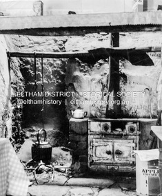 Eltham District Historical Society Inc
Photograph - Black and White Print, George W. Bell, Detail, Kitchen, Birch Cottage, Yarra Glen Road, Smiths Gully, Aug 1969
... land but was unable to because it was part of the creek reserve. The documents show that the house existed at that time. Birch died in 1932 and his daughter Honor Mary Birch was granted a permit to occupy the residence. ...land but was unable to because it was part of the creek reserve. The documents show that the house existed at that time. Birch died in 1932 and his daughter Honor Mary Birch was granted a permit to occupy the residence. ...EDHS Newsletter No. 182, September 2008 In the late 1970s when our Society was the Shire of Eltham Historical Society, an offer was made to the Society regarding use of an old cottage at Christmas Hills. For various reasons the offer ultimately lapsed The cottage sat beside Watsons Creek just outside the then Shire of Eltham but following municipal restructuring it now lies within the Shire of Nillumbik. At that time some research on the cottage was carried out for the Society by Keith Chappel as part of a larger research project that he was doing. Keith's notes were taken from Lands Department records and showed that house is the subject of a permissive occupancy of Crown land comprising the creek reserve. In 1903 a Miners Right of one acre in area was granted to Edwin Samuel Birch. In 1907 Birch applied to purchase this land but was unable to because it was part of the creek reserve. The documents show that the house existed at that time. Birch died in 1932 and his daughter Honor Mary Birch was granted a permit to occupy the residence. The future of the cottage remains precarious because of its location on Crown land. In 2007 the Andrew Ross Museum began a campaign to ensure that it is preserved. It included a video presentation on the history of the cottage under the title of "This Old House- Birch Cottage". Black and white photograph Also digital scan file from original negativeWilliams Cottage Panton Hill 1969 Not to be reproduced without permission G.W. Bell Photographer Elthamhouses, cottage, early settlers, yarra glen road, smiths gully, williams cottage, watsons creek, christmas hills, birch cottage, edwin samuel birch, honor mary birch, bronny handfield collection -
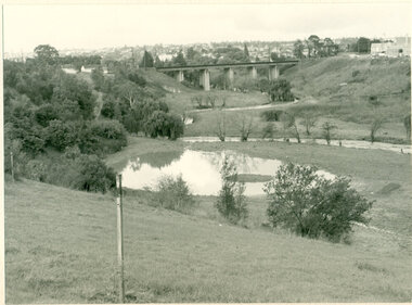 Darebin Parklands Association
Rockbeare Park and Darebin Creek, August 1974, 1974
... grant for this work to take place. Darebin Parklands Association stormed the meeting to get this decision reversed, and the wetlands were never filled in. B&W photograph. Shows wetlands and Darebin Creek. Albion Reid land ...In 1972 Ivanhoe Progress Association planned to fill in the wetlands because they felt it bred mosquitos, and they obtained a grant for this work to take place. Darebin Parklands Association stormed the meeting to get this decision reversed, and the wetlands were never filled in.B&W photograph. Shows wetlands and Darebin Creek. Albion Reid land on fore bank. View from the north with panorama of Kew in the distance This item and all other Darebin Parklands Association archival material is now held by State Library Victoria (Accession No: YMS 13746). Please contact State Library Victoria if access is required. -
 Geoffrey Kaye Museum of Anaesthetic History
Book, Longman, Brown, Green and Longmans, Physical Description of New South Wales and Van Diemen's Land. Accompanied by a geological map, sections, and diagrams, and figures of the organic remains, 1845
... Strzelecki Van Diemen's Land Wilson, Gwen Pugh, William Launceston Green and Longmans [front title page, two black ink stamps that have bled through to the next page] W R.PUGH [front title page, black ink, cursive writing] H Grant \ 5 May 1910 [front title page, pencil, cursive writing, written around Pugh's stamp] Purchased from \ (unrecognizable script) [front title page, previous owner's name was rubbed out and consequently tore the page making the entry unreadable] [Inner back cover, bottom LHS, blue stamp] BOUND BY \ WESTLEYS & \ CLARK \ LONDON [Inner front cover, bottom LHS, black and purple ink] P65 \ 76 \ 78 \ 98 \ 163 \ 164 \ 217 Tan coloured cloth book with an embossed circular motif on the centre of the front and back cover. ...Dr. Gwen Wilson, Emeritus historian, gifted this book at ANZCA's first independent Annual Scientific Meeting held in Launceston in 1994. Dr Wilson presented this gift after her speech about the life of William Russ Pugh and his significant contribution to anaesthesia in Australia. It is unclear as to how the book came into Dr Wilson's possession. Published in London, 1845, for Longman, Brown, Green and Longmans, this book was formally owned by general practitioner Dr William Russ Pugh, being the first medical practitioner in Australia to administer ether anaesthetic on 7 June 1847, in Launceston. The author of the book, P E De Strzelecki acknowledges Pugh for his assistance during his stay in Launceston and for allowing him the use of his laboratory for the analysis of the soils and minerals that were subsequently reported in this book (Page 131). Tan coloured cloth book with an embossed circular motif on the centre of the front and back cover. The same embossed motif is repeated four times along the spine of the book. An embossed design of small, four petal flowers borders the edge of the front and back cover. The title of the book 'Strzelecki's New South Wales and Van Diemen's Land' is printed in gold on the spine. The cloth has come unstuck at various places around the spine and a small section is missing from the base of the spine. The cover is worn and has numerous dark stains possibly from mould. The book contains 19 engraved and lithographed plates. This includes a handcoloured octavo folding, geological map, bound as a frontispiece, depicting the NSW coast down to Gippsland and Tasmania, a fold out single colour geological cross section of the Newcastle Coal Basin, 14 plates illustrating shellfish and flora and three tinted lithographs. Single page maps at the back illustrate wind patterns around Australia. [front title page, two black ink stamps that have bled through to the next page] W R.PUGH [front title page, black ink, cursive writing] H Grant \ 5 May 1910 [front title page, pencil, cursive writing, written around Pugh's stamp] Purchased from \ (unrecognizable script) [front title page, previous owner's name was rubbed out and consequently tore the page making the entry unreadable] [Inner back cover, bottom LHS, blue stamp] BOUND BY \ WESTLEYS & \ CLARK \ LONDON [Inner front cover, bottom LHS, black and purple ink] P65 \ 76 \ 78 \ 98 \ 163 \ 164 \ 217strzelecki, van diemen's land, wilson, gwen, pugh, william, launceston, green and longmans -
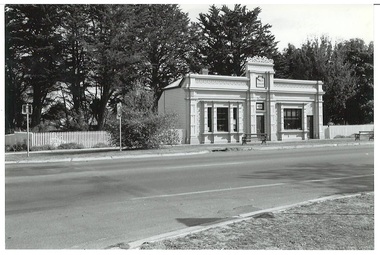 Buninyong & District Historical Society
Photograph - Black and white photograph, Former Free Library Warrenheip Street Buninyong, 9 April 1994
... Built in 1861 on land made available by Mr. Robert Allen. Grant received through municipal council and State Government. ...Buninyong & District Historical Society Old Court House, Buninyong Town Hall 313 Learmonth Street Buninyong goldfields Built in 1861 on land made available by Mr. Robert Allen. Grant received through municipal council and State Government. ...Built in 1861 on land made available by Mr. Robert Allen. Grant received through municipal council and State Government. Building functioned as a library until 1926. Taken over by Buninyong Cemetery Trust and eventually fell into serious disrepair. Restored in the 1980s after great community effort, dedication and financial contributions.An important early building in the township noted for its unusual and individual classical facade of Oregon pine. Placed on Historical Buildings Register.Black and white photograph of Former Free Library built in1861. Warrenheip streetscape of former free library, currently Buninyong Information Centre, Eastern facade fully visible and Southern weatherboard side. Mature pine trees visible to the side and rear of building. Reading room on left of entrance door and former shop and residence on right.free library, information centre, mr. robert allen, buninyong cemetery trust, mechanics institutes -
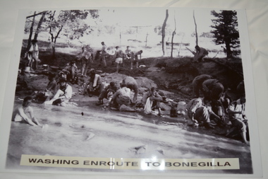 Wangaratta RSL Sub Branch
Photograph, c1940
... The Unit was granted the Freedom of the City by the Rural City of Wangaratta in 1990 and one of the first, if not the first, to receive this type of honour. 2/24th battalion wangaratta Washing enroute to Bonegilla Reproduced black and white photograph of unknown soldiers bathing and sitting on a river bank in bush land. ...In July 1940, the 2/24th Battalion was formed in Wangaratta. On the 27th September, after weeks of hard training the Battalion marched out to Bonegilla to continue training prior to overseas deployment to the Middle East in November, 1940. This image depicts soldiers bathing and washing during the 60 mile march.The 2/24th Battalion was an infantry battalion of the Australian Army, which served during World War II .A unit of all-volunteers, it was formed in July 1940 from primarily Victorian volunteers and was known as "Wangaratta's Own" because of the time the battalion spent in the town during its formative period prior to deployment overseas. It served in North Africa in 1941–1942 as part of the 26th Brigade, which was assigned to the 7th Division, before being reassigned to the 9th Division. In early 1943, the battalion returned to Australia and later took part in campaigns against the Japanese in New Guinea in 1943–1944 and Borneo in 1945, before being disbanded in 1946. The 2/24th suffered the highest number of casualties of any 2nd AIF infantry battalion. The Unit was granted the Freedom of the City by the Rural City of Wangaratta in 1990 and one of the first, if not the first, to receive this type of honour.Reproduced black and white photograph of unknown soldiers bathing and sitting on a river bank in bush land. Washing enroute to Bonegilla2/24th battalion, wangaratta -
 Lakes Entrance Historical Society
Photograph, George Price Grant Metung, 1900 c
... Sepia toned photograph showing large Bullock team of George Price Grant of Metung moving a small building in Metung district four men visible one on right with an axe other with whips. Bare hill and a few dead trees in background showing early land improvement for agriculture Metung Victoria...Lakes Entrance Historical Society 4 Marine Parade Lakes Entrance gippsland Myrtle Fish collection daughter of George Price Grant Genealogy Settlers Sepia toned photograph showing large Bullock team of George Price Grant of Metung moving a small building in Metung district four men visible one on right with an axe other with whips. Bare hill and a few dead trees in background showing early land improvement for agriculture Metung Victoria George Price Grant Metung Photograph ...Myrtle Fish collection daughter of George Price GrantSepia toned photograph showing large Bullock team of George Price Grant of Metung moving a small building in Metung district four men visible one on right with an axe other with whips. Bare hill and a few dead trees in background showing early land improvement for agriculture Metung Victoria genealogy, settlers -
 Surrey Hills Historical Society Collection
Planning report, City of Boroondara, City of Boroondara planning report re 171 Union Road, Surrey Hills, 19/07/2004
... land diagonally opposite at 174 Union Road and had a purpose-built home / surgery constructed. Later the site was occupied by COR then a BP petrol station. union road redevelopment shops town planning A detailed proposal regarding the redevelopment of the petrol station site on the corner of Union Road and Montrose Street, Surrey Hills into a 2 storey office and shop building with basement parking and access from Montrose Street. It includes attachments showing plans, elevations and details regarding objectors. The application was granted ...171 Union Road was part of the Thomas Zeplin estate. It originally had a Victorian house on it built by the Zeplin family. This was leased by Dr Percy Liddle and then Dr James Landells Blakie. Dr Blakie purchased land diagonally opposite at 174 Union Road and had a purpose-built home / surgery constructed. Later the site was occupied by COR then a BP petrol station.A detailed proposal regarding the redevelopment of the petrol station site on the corner of Union Road and Montrose Street, Surrey Hills into a 2 storey office and shop building with basement parking and access from Montrose Street. It includes attachments showing plans, elevations and details regarding objectors. The application was granted subject to additional conditions being met. union road, redevelopment, shops, town planning -
 Victorian Aboriginal Corporation for Languages
Book, Wendy Baker, Searching land records in Victoria : an introduction, 1996
... Victorian Aboriginal Corporation for Languages 33 Saxon Street Brunswick melbourne genealogy Victorian history land tenure land grants maps, charts, photocopies of records Searching land records in Victoria : an introduction Book Wendy Baker ...maps, charts, photocopies of recordsgenealogy, victorian history, land tenure, land grants -
 Port Fairy Historical Society Museum and Archives
Photograph, Pt Fairy Hospital looking east 1890, 1890
... The land for this building was granted to the Benevolent Society by James Atkinson in 1850. ...Port Fairy Historical Society Museum and Archives 30 Gipps Street Port Fairy great-ocean-road The land for this building was granted to the Benevolent Society by James Atkinson in 1850. ...The land for this building was granted to the Benevolent Society by James Atkinson in 1850. Tenders were called for a new "Benevolent Asylum" in 1855, the foundation stone having been laid and by 1856 the first part of the Hospital was completedBlack and white photograph New addition to the hospital with i’ts bay windows. 5 women and two men posed to the sidehospital, health service, nurses, bay window -
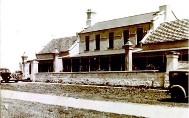 Port Fairy Historical Society Museum and Archives
Photograph
... The land for this building was granted to the Benevolent Society by James Atkinson in 1850. ...Port Fairy Historical Society Museum and Archives 30 Gipps Street Port Fairy great-ocean-road The land for this building was granted to the Benevolent Society by James Atkinson in 1850. ...The land for this building was granted to the Benevolent Society by James Atkinson in 1850. Tenders were being called for a new "Benevolent Asylum" in 1855, the foundation stone having been laid and by 1856 the first part of the Hospital was completed. this photograph shows there have been extensions to both sides of the hospital by this time 1920Black and white photograph of Exterior of hospital with verandah stone fence and gates two cars hospital, institution, villiers street, benevolent asylum, health service -
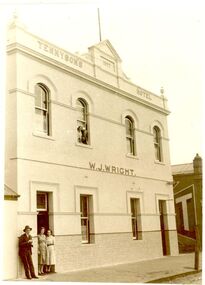 Port Fairy Historical Society Museum and Archives
Photograph
... The Bench wondered about creating a precedence of granting a license to a married woman, who was living with her husband, (licenses were only granted to the widows of licensees at that time), so the application was postponed for 14 days, but eventually Mrs Wall won her case. In 1882 Patrick Tennyson took over the lease of the Farmer’s Inn and applied to change the name to Tennyson’s Hotel. In 1885 he bought the freehold in the Great Land...The Bench wondered about creating a precedence of granting a license to a married woman, who was living with her husband, (licenses were only granted to the widows of licensees at that time), so the application was postponed for 14 days, but eventually Mrs Wall won her case. In 1882 Patrick Tennyson took over the lease of the Farmer’s Inn and applied to change the name to Tennyson’s Hotel. In 1885 he bought the freehold in the Great Land ...The small building on the left is the Farmers Inn, and was built about 1849, when James Brown became the first licensee. In 1854 John Walwyn Taylor moved from the Sally Ann to take over, and remained there until 1857, when he moved to his new hotel The Star of the West built on the old Sally Ann site. John Wall then became the new licensee of the Farmers Inn. In 1876 his wife Bridget made an application for the license to be transferred to her as “her husband suffered from rheumatism, and there were certain other reasons why the license should be transferred to her hands”. The Bench wondered about creating a precedence of granting a license to a married woman, who was living with her husband, (licenses were only granted to the widows of licensees at that time), so the application was postponed for 14 days, but eventually Mrs Wall won her case. In 1882 Patrick Tennyson took over the lease of the Farmer’s Inn and applied to change the name to Tennyson’s Hotel. In 1885 he bought the freehold in the Great Land Sale for £780. 12s. 8d., and in December, carried out extensive renovations. The local press reported that “the rooms were quite tasteful, the Billiard room commodious and well ventilated, and that the old hotel had not looked so good for years”. The double storied part of the hotel was added in 1893. Patrick Tennyson had a colourful career. He was born in Charlemont, County Armagh in 1846. When he was 21, he served as a papal guard at the Vatican for 2 years and then entered the Marist Brothers novitiate in Beauchamps. In 1872 he was one of three brothers to accompany Brother Ludovic to Sydney; he was then aged 23. After 5 years he withdrew from the Congregation and moved to Victoria, where he took up teaching, first at Rosedale near Sale, then at Crossley, by which time he was married to Anne White. They had eight children, three dying in infancy. Eight months after he took over the Farmers’ Inn, he was elected to the Borough Council, and served as Mayor in 1897. His great interest was sport, was Secretary of the Race Club for 20 years and supported the local Football Club by donating a silver cup for local competitions. Patrick Tennyson died in 1904. The hotel continued under various licensees until it burned down in 1977 under the name of “The Fishermen’s Arms”. Well known main street hotel no longer exists Sepia photograph of 2 story building with tiled wainscoting male and 2 females in doorway and 2 females in window upstairshotel, building, sackville street, patrick tennyson, w.j.wright -
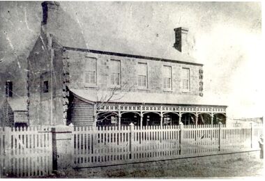 Port Fairy Historical Society Museum and Archives
Photograph
... The land for this building was granted to the Benevolent Society by James Atkinson in 1850. ...Port Fairy Historical Society Museum and Archives 30 Gipps Street Port Fairy great-ocean-road The land for this building was granted to the Benevolent Society by James Atkinson in 1850. ...The land for this building was granted to the Benevolent Society by James Atkinson in 1850. Tenders were being called for a new "Benevolent Asylum" in 1855, the foundation stone having been laid and by 1856 the first part of the Hospital was completed. This photo taken in 1860 shows the very first building made from local bluestone. The hospital is thought to be the first such building in VictoriaBlack and white photograph of Bluestone 2 story building with verandah and paling fencehospital, institution -
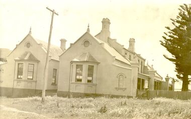 Port Fairy Historical Society Museum and Archives
Photograph
... The land for this building was granted to the Benevolent Society by James Atkinson in 1850. ...Port Fairy Historical Society Museum and Archives 30 Gipps Street Port Fairy great-ocean-road The land for this building was granted to the Benevolent Society by James Atkinson in 1850. ...The land for this building was granted to the Benevolent Society by James Atkinson in 1850. Tenders were being called for a new "Benevolent Asylum" in 1855, the foundation stone having been laid and by 1856 the first part of the Hospital was completed. These extensions probably carried out 1930's?????Black and white photograph of Right side of hospital new extension with bay windowshospital, institution, health service, extension, benevolent asylum, benevolent society