Showing 110319 items matching "roads"
-
 Melton City Libraries
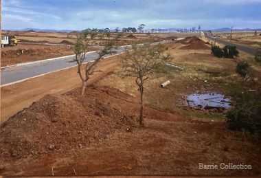
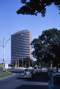
Photograph, West Melton-Coburns Road, 1969
Coburns Road - 19th c family descendents living in Melton. Coburn Primary School Cr George Coburn. 1930’s. December 1935 Shire President Cr Geo Coburn convened meeting to form the Bush Fire Brigade. Road construction of Service road and beginnings of West Melton subdivision. West Melton-Early Division View of Coburns Road. council, local significant events -
 Vision Australia
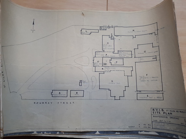
Plan - Image, RVIB Maintenance drawing, April 1963 - November 1966
A series of maintenance drawings were made or copied by an architectural firm. These plans include: 1 - St Kilda Road Property - a site map of the buildings and grounds with the names of the various areas added. 2 - St Kilda Road Central Building (copied from a RAAF drawing) showing rooms on the ground floor. 3 - St Kilda Road Central Building (copied from a RAAF drawing) showing rooms on the first floor. 4 - St Kilda Road Central Building roof plan. 5 - St Kilda Road Factories showing the layout on the ground floor. 6 - St Kilda Road Factories showing the layout on the first floor. 7 - St Kilda Road building showing all three floors of the building rented out to Alfred Hospital. 8 - St Kilda Road caretaker, factory, fundraising and rehabilitation training buildings. 9 - Raleigh Street, Prahran hostel layout for both girls and boys.9 pages of plans of buildings on St Kilda road siteVarious - see individual plansmyer house, royal victorian institute for the blind, plans, raleigh street hostel, alfred hospital -
 Whitehorse Historical Society Inc.
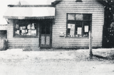
Photograph, Forest Hill Post Office
The first Post Mistress and Storekeeper was Catherine Peacock. The Building was located at259 Canterbury Road and was demolished in1950. The next Forest Hill Post Office was situated on the North West Corner of Canterbury and Springvale road.Copy of a Black & White photo of the Forest Hill Post Office, near the intersection of Springvale Road, c1926. and Canterbury road. In the 2000s it was the site of Swan Hardware.post offices, forest hill post office -
 Whitehorse Historical Society Inc.
Document, Mitcham Shopping Centre redevelopment, 1960s-1970s
Collection of papers relating to the Mitcham Chamber of Commerce proposal for redevelopment of Mitcham Shopping Centre.Collection of papers relating to the Mitcham Chamber of Commerce proposal for redevelopment of Mitcham Shopping Centre, in particular, parking, and reconstruction of Whitehorse Road by the Country Roads Board. Incl. correspondence, plans, news cuttings.Collection of papers relating to the Mitcham Chamber of Commerce proposal for redevelopment of Mitcham Shopping Centre.mitcham shopping centre, whitehorse road, mitcham, mitcham chamber of commerce, armstrong, raleigh edward, car parks, victoria. country roads board -
 Robin Boyd Foundation
Slide, Robin Boyd, 1965
Colour slide in a mount. BP House (1964), St Kilda Road, Melbourne, Australia. (Architect: Anthony B Armstrong.)Made in Australia / 5 / JAN 65M / B-P St Kilda Road 1964 (Handwritten)melbourne, robin boyd, slide -
 Robin Boyd Foundation
Slide, Robin Boyd, 1965
Colour slide in a mount. BP House (1964), St Kilda Road, Melbourne, Australia. (Architect: Anthony B Armstrong.)Made in Australia / 9 / JAN 65M / B-P St Kilda Road 1964 (Handwritten)melbourne, robin boyd, slide -
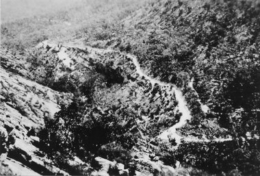
 Kiewa Valley Historical Society
Black and White photograph of Road Making Machinery, Kiewa Road Making 25/08/1938 No. 2, 25/08/1938
Construction of the main road from South Tawonga to the Bogong High Plains, to provide access to the construction sites for the new Kiewa Hydro Electric Scheme, was commenced early in 1938, the work being undertaken on behalf of the commission by the Country Roads Board. For the construction work, the Commission purchased three Caterpillar - model R07 - diesel crawler tractors equipped with Kay Brunerei (Brunner) hydraulically operated trailbuilders (angle dozers). This acquisition resulted from a visit to the United States of America in May, 1937 by the Construction Engineer ( Mr. C.H. Kernot) and Assistant Civil Engineer ( Mr. J.F. Douglas) where they saw this relatively new type of equipment in use. With the co-operation of the CRB, the Commission demonstrated the operation of these machines at Fishermen's Bend on 6th April, 1938. They were then sent to Kiewa where they commenced operation towards the end of the month. From South Tawonga, the route let immediately across the Western Branch of the Kiewa River necessitating the construction of a bridge 100 feet long. By the end of 1939, the excavation had been 'opened up' for a distance of 19 1/2 miles (approx. 31 km.) and of this length, 10 miles (approx. 16 km.) had been surfaced. (see KVHS 0328)The purchase of this type of mechanical equipment in road making was a huge investment, as prior to this most of the work would have been done manually with the use of picks and shovels. Not only were many months of hard manual labour saved, but a very significant amount of time in providing access to the proposed work sites for the new Kiewa Hydro Scheme. This photo is an excellent reminder of how primitive the early machinery was compared to the present but also represents the forward thinking of the State Electricity Commissions engineers in purchasing such innovative equipment.A black and white photograph of road making near Mt. Beauty in 1938. Mount Beauty hills can be seen in the background with cleared land for grazing in the fore ground.Hand printed in black ink at the top of the photograph is 'Kiewa Road Making 25/8/1938'. On the right hand corner has been printed the number 2. It has been printed on gloss Velox paper.road making, state electricity commission, caterpillar tractor, kiewa, secv -
 Eltham District Historical Society Inc
Slide, Southern alignment of Montpelier Drive looking north up Bonds Road, Lower Plenty, 18 July 1972, 1972
Water drainage work undertaken by Eltham Shire Council in Bonds Road, Lower Plenty outside the Martin property opposite Montpelier Drive, July 1972 The water is not able to enter the pit on the northern side of Montpelier. It then flows along and across Bonds Road.35 mm colour positive transparency Mount - Agfacolor Service (Blue)Bonds Road (Martin property) 12.10 pm 18.7.72bonds road, drainage works, eltham shire council, infrastructure, lower plenty, martin property, montpelier drive -
 Halls Gap & Grampians Historical Society
Photograph - Sepia, C 1930s
... Roads ...The Mt Victory Rd was originally called the Bluff Road After improvements and extension it was renamed at its opening by Lady Somers in Mar 1930Photo shows the newly formed Mt Victory Rd. with the bridle track above it Photo taken from the top of the Elephant's hideaccess routes, roads -
Whitehorse Historical Society Inc.
Newspaper - Articles, Central Road, Nunawading, 1953
Collection of Age and Reporter articles re native gums and wattlesCollection of Age and Reporter articles re native gums and wattles which were felled in Central Road, Nunawading for road widening which led to protests from angry residents.Collection of Age and Reporter articles re native gums and wattlescentral road., nunawading, roads and streets, native plants, moore, herbert, field, jean, uhl, wylie, alan -
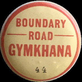 City of Moorabbin Historical Society (Operating the Box Cottage Museum)
Badge - Boundary Road - Gymkhana, ca. 1929
The Murrumbeena Branch of the Alfred Hospital Auxiliary held a grand charity gymkhana on 7 September, 1929 at the Central Speedway, Boundary Road, Bentleigh. It was a full racing program with several trotting events. There were also games and several well-stocked stalls. Early settler market gardeners were generous with their support for local hospitals and charitable associationsMetal Pin Boundary Road - GYMKHANA - 44alfred hospital auxillary, murrumbeena, boundary road, bentleigh, central speedway, pioneers, moorabbin -
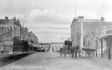 Surrey Hills Historical Society Collection
Work on paper - Photograph, Canterbury Road, near the corner of Union Road, 1911
J A Geer's grocery store operated from 1909-1912 on the site established by George Sim in 1884. He bought a house and added a shop where, in 1889, he established the first post office in the area. Prior to this residents had to go the Box Hill to collect mail. Date is approximate.This records one of the earliest businesses in Surrey Hills. To begin with, businesses developed along Canterbury Road rather than Union Road, in part because of the muddy nature of the land north of the railway line.Black and white photo taken from a postcard of Canterbury Road, near the corner of Union Road, looking west in 1906 or 1907. Two children play on the LHS of the street and there is a man on a horse and carriage, and a cart, on the RHS. Buildings on the RHS are the Surrey Family Hotel and J A Geer's grocery store; on the LHS is a row of double-storey terraces including Hansen's Terrace on Canterbury Road to the west of Union Road.On LHS within the original image is 'Canterbury Road, Surrey Hills'; on the rear in top LH corner in blue biro in Jocelyn Hall's handwriting "J H / spare"canterbury road, geer's grocery store, surrey family hotel, businesses, horse drawn vehicle, hansen's terrace, post card, mr j a geer -
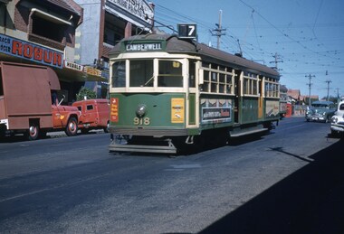 Melbourne Tram Museum
Slide, John Webster, 5/04/1960 12:00:00 AM
Colour slide, Kodak, white cardboard of tram SW6 918, in Burke Road, Gardiner after turning from Malvern Road, route 7, Camberwell. In the background are the shops since removed advertising Robur tea and the Herald and the Australasian Post. Slide dated 5-4-60.Hand writing on rear in ink "5-4-60 tram 918 Burke Road Gardiner Victoria"trams, tramways, sw6 class, camberwell, burke rd, route 7, gardiner, tram 918 -
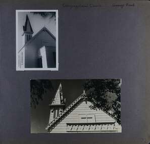 Glen Eira Historical Society
Album - Album page, Congregational Church, Grange Road, Circa 1972
This photograph is part of the Caulfield Historical Album 1972. This album was created in approximately 1972 as part of a project by the Caulfield Historical Society to assist in identifying buildings worthy of preservation. The album is related to a Survey the Caulfield Historical Society developed in collaboration with the National Trust of Australia (Victoria) and Caulfield City Council to identify historic buildings within the City of Caulfield that warranted the protection of a National Trust Classification. Principal photographer thought to be Trevor Hart, member of Caulfield Historical Society. Most photographs were taken between 1966-1972 with a small number of photographs being older and from unknown sources. All photographs are black and white except where stated, with 386 photographs over 198 pages. This church has since become the Greek Orthodox Church. From Victorian Heritage Database: Citation for Greek Orthodox Church HO84 https://vhd.heritagecouncil.vic.gov.au/places/43587 (as at 19/10/2020) The former Primitive Methodist, later Congregational, church at 152 Grange Road, Glenhuntly, is a small timber building, erected in 1885 (89?) in South Melbourne and relocated to Glenhuntly in 1909. It is a highly individual picturesque timber structure with distinctive spire and timber enrichment. It has aesthetic, historical and social significance. Its aesthetic value is derived from the choice of materials and picturesque Gothic Revival character showing American influence. Its historical value is derived from its survival as a rare example of a Primitive Methodist Church building whilst its social value hinges on its early roles as a place of worship for the Primitive Methodists in South Melbourne and the Congregationalists in Glenhuntly.Page 72 of Photograph Album with two photographs (one portrait and one landscape) of the upper exterior and tower of the Congregational Church on Grange RoadHand written: Congregational Church, Grange Road [top right] / 72 [bottom right] trevor hart, congregational church, grange road, gothic revival, carnegie, glen huntly, glenhuntly, greek orthodox church, primitive methodist church, spire, timber buildings -
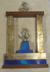 Geelong Cycling Club
Memorabilia - Trophy, 1983-1988
This trophy was important in the years 1983-1988 as it recorded the winners of the prestigious Road Race run by the Geelong West Cycling Club over those years. The 1985 winner - Don Wilson was a two time Australian Open Road Race champion and also represented Australia in the 1968 Olympic Games in Mexico in the cycling road race. This trophy records the winners of a Road Race run by the Geelong West Cycling Club during the years 1983-1988.Trophy for winner of the Penn Memorial Road Race. The trophy is in the shape of a gateway with one silver representation of a cyclist on the top of the gateway and another on a pedestal in the middle of the gateway. The two inner supports to the gate have a stylised decorative pattern on them in black, gold and red. On the left hand upright winners' names have been engraved. Additional engraving is at the base of the trophy."Geelong West Cycling Club/PENN MEMORIAL - ROAD RACE/IN HONOUR OF R.L. PENN(Senior) W.J. PENN/ Donated By The - Penn Families/1983 Z. Szalinski/1984 A. McPherson/1985 Don Wilson/1986 Ken Lewins/ 1987 Peter Wood/1988 Peter Cotter"geelong cycling club; geelong west cycling club; penn memorial road race; penn family; z. szalinsk; a. mcpherson; don wilson; ken lewins; peter wood; peter cotter; -
 Marysville & District Historical Society
Photograph (item) - Colour tinted photograph, Valentine Publishing Co. Pty. Ltd, The Road to Cumberland Valley, Marysville. No. 1, 1923-1963
An early colour tinted photograph of the intersection of the Buxton Marysville Road and the Marysville-Wood's Point Road.An early photograph of the Buxton Marysville Road and the Marysville-Wood's Point Road intersection. The Marysville-Buxton Road joins the Maroondah Highway which leads to Alexandra. The Marysville-Woods Point Road was originally part of the Yarra Track, constructed in the early 1860s to provide access between Healesville and the Woods Point Goldfields. Despite the steep terrain and engineering difficulties, the Yarra Track soon became a busy route used by pack horses, horse-drawn drays, and wagons. Today this sealed mountain road is a popular scenic drive between Marysville and Warburton. On the right of the photograph can be seen 'The Crossways Hotel' which is circa 1920 and one of the oldest buildings still standing in Marysville. 'The Crossways Hotel' survived the 2009 Black Saturday bushfires, through the efforts of the owner using buckets of water from the nearby Steavenson River. In the background can be seen the Poontawan Guest House which later became the Marysville Chalet Guest House which was on the site of the original Steavenson's Hotel. That guest house no longer exists and the Christ Church stands on the land where the guest house once stood. This photograph was published by the Valentine Publishing Co Pty. Ltd as a souvenir of Marysville.marysville, victoria, marysville chalet guest house, crossways hotel, christ church marysville, poontawan guest house, steavenson's hotel, valentine publishing co, souvenir, yarra track, wood's point road, mining, buxton-marysville road, marysville-wood's point road, maroondah highway, alexandra -
 Glen Eira Historical Society
Album - Album page, Heatherbrae, 73 Neerim Road, Circa 1972
This photograph is part of the Caulfield Historical Album 1972. This album was created in approximately 1972 as part of a project by the Caulfield Historical Society to assist in identifying buildings worthy of preservation. The album is related to a Survey the Caulfield Historical Society developed in collaboration with the National Trust of Australia (Victoria) and Caulfield City Council to identify historic buildings within the City of Caulfield that warranted the protection of a National Trust Classification. Principal photographer thought to be Trevor Hart, member of Caulfield Historical Society. Most photographs were taken between 1966-1972 with a small number of photographs being older and from unknown sources. All photographs are black and white except where stated, with 386 photographs over 198 pages.From Victorian Heritage Database citation for Heatherbrae HO46 https://vhd.heritagecouncil.vic.gov.au/places/120933 as at (28/10/2020) "Heatherbrae" at 73 Neerim Road, Glenhuntly, is a substantial Victorian residential complex made up of two principal construction stages (pre 1876 and c. 1890) and outbuildings including stables. It is aesthetically, historically and socially significant. Its aesthetic value is demonstrated by the manner in which the two periods of construction survive, the earliest being of greater architectural interest on account of its tower and facade treatment, the latter phase adopting a common villa form. The importance of the complex is heightened by its intact state and surviving outbuildings. "Heatherbrae's" historical significance lies in its link with locally known business man and Shire of Caulfield councillor, John Charles Holland. Its social value rests on its ability to demonstrate a past lifestyle. Page 143 of Photograph Album with 2 landscape photographs of Heatherbrae on Neerim Road - paving insignia and side view.Handwritten: "HEATHERBRAE" 73 NEERIM ROAD [top] / STABLE [under bottom photo] / 143 [bottom left]trevor hart, chimneys, cast iron columns, return verandah, garden, 1870's, neerim road, booran road, 1880's, 1890's, mansion, john c. holland, bluestone foundations, italianate, iron roofed balcony, cast iron balustrade, mosaic tiles, cast iron lookout, flagpole, george f griffiths, residential villa, caulfield, heatherbrae, victorian style, cast iron work, stables, outbuildings, john holland, george griffiths, councillors, mansions -
 Halls Gap & Grampians Historical Society
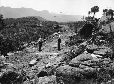
Photograph - B/W
... Roads ...Photo shows 2 men standing on rough formation of road to Mt William. One man is wearing a hard-hat, the other a felt hat.access routes, roads, access routes, mt william road -
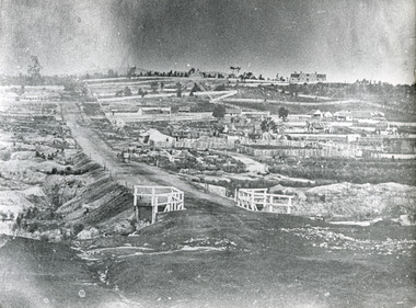 The Beechworth Burke Museum
Photograph, c.1863
Taken in Beechworth, this photograph depicts Albert road bisecting the Spring Creek Diggings. The foreground of the photograph features a small bridge, while in the background, right-hand-side, Benevolent Hospital can be seen. In the centre of the photograph can be seen a horse and cart travelling along the road. This photograph shows historical and research value in its depiction of Beechworth in the late 1800s. It features a key historical site, the Benevolent Hospital, as well providing a historical look at a street that operates in Beechworth in the present day.Black and white, rectangular photograph printed on matt photographic paper, unmountedReverse: PH 238 / 1997.2462 / Albert Road . 1863 . 1800s beechworth, 1860s beechworth, beechworth, spring creek, benevolent asylum, albert road -
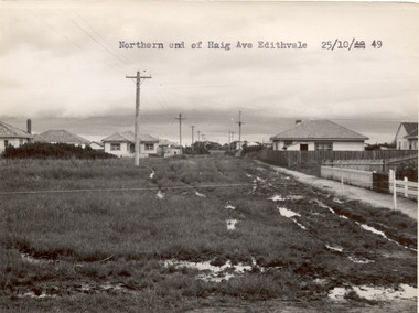 Chelsea & District Historical Society Inc
Photograph - Haig Avenue, Edithvale, 1949
This photo is one of a collection of photos taken during Alan Niemann's - Drainage-Road Making Scheme.Two black and white photo of the northern and southern ends of Haig Avenue, Edithvale. The road is unmade with grass growing on the road, is rutted with large puddles, houses line both sides and electricity poles are both side of the road. unmade street, aspendale, alan niemann, drainage-road making scheme, haig avenue, edithvale -
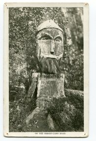 Orbost & District Historical Society
black and white photograph, 1920s
Pons asinorum was the name given to a wooden carving made by road worker Finlay Munro in the early 1920s at Boulder Creek, on the old Princess Highway, between Orbost and Cann River. The carved face was said to mock the supervising engineer after an argument about putting the road alignment across a swamp that required new bridges. The Italian workmen had advocated for a different route to avoid the need for building new bridges across the swamp. This photograph is from a set of thirteen black and white postcards in a fold-out format.This is a photograph of an iconic tourist attraction which records the woodworking skills of workers in the early 20th century. The carving is no longer there.A small black / white photograph of a face carved into a tree stump.on front at bottom - ON THE ORBOST CANN ROADwoodcarving pons-asinorum boulder-creek-east-gippsland princess-highway -
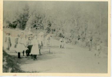 Mt Dandenong & District Historical Society Inc.
Photograph, School Sports Olinda 1909
View of school children from Olinda State school at the Sports on Mernda (now Coonara) Road in 1909. The descriptive text on the reverse of this photograph was hand written by John Lundy-Clarke.Olinda 1909 School sports on the (now) Coonara Road below the school. olinda, sports, sports carnival, mernda road, coonara road, olinda school, school, school children -
 Eltham District Historical Society Inc
Slide, West side of Bonds Road at culvert end wall, Lower Plenty, 18 July 1972, 1972
Water drainage work undertaken by Eltham Shire Council in Bonds Road, Lower Plenty outside the Martin property opposite Montpelier Drive, July 1972 Pitchers in foreground were part of the end wall which was eroded out due to water crossing the road and not going through the culvert. 35 mm colour positive transparency Mount - Agfacolor Service (Blue)Bonds Road (Martin property) 12.10 pm 18.7.72bonds road, drainage works, eltham shire council, infrastructure, lower plenty, martin property, montpelier drive -
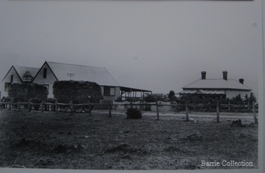 Melton City Libraries
Photograph, Chaff cutting and hay-pressing mills, 1909
In the early 1900’s Charles Ernest Barrie and his brother Ted were in partnership in a Chaff cutting and Ha y processing Mill on the corner of Station and Brooklyn road Melton South. By 1906 Charles Ernest and James Edwin were in partnership in the Station Road mill when a connecting rail line across Brooklyn Road for a siding was constructed to the Melton Railway Station. In 1911 the Mill’s letterhead shows C.E. BARRIE Hay Pressing and Chaff Cutting Mills. This Mill as sold to H S K Ward in 1916 and stood until 1977 when it burnt down in a spectacular fire.Owned by C.E Barrie. Buildings were on the west side of Station Road in Melton South, 100 metres north of Brooklyn Roadlocal identities, pioneer families, agriculture -
 St Kilda Historical Society
Photograph, c. 1970s?
stamped on back: Country Roads Board negaitve no. 75 3124Gblack and white photograph unmounted, good conditionH7 St Kilda road. When reproduced Pleas acknowldge Country Roads Board, Victoria Australia. Negative no. 75-3124G. Date: �., General Description:�.. -
 Bendigo Historical Society Inc.
Photograph - HARRIS COLLECTION: MALE PHOTO
Studio portrait man aged around 40 years. Beard & moustache. Written caption on reverse 'Capt. Riddie' 1896. Printed on reverse. Artist & Photographer A J Hilder 267 Barking Road Plaistow E. Same printed on front.A J Hilder 267 Barking Road Plaistow Essex.photograph, person, male -
Ringwood and District Historical Society
Land titles and plan, Victorian Titles Office, Titles and plans of Ringwood Land between Mullum Land and Wonga Rd. (Re Ann Jane Kennedy). 1907, 1-Oct-07
The documents pertaining to Ann Jane Kennedy inheriting the land from her late husband Samuel John Kennedy and the history of the transfers of land from Ann Jane Kennedy in 1907 until the title was cancelled in 1925 to James Melbourne Ross. The area was 10 acres between Mullum Mullum Road and Wonga Road retrieved from Titles Office.Ten pages of photocopied titles and plans of land in Ringwood between Mullum Road and Wonga Road, also transfer of original land. -
 Kew Historical Society Inc
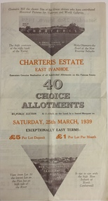
Plan - Subdivision Plan, Charteris Estate, East Ivanhoe, 1939
The Charteris Estate in Ivanhoe was sold in a number of sections. Copies of a subdivision plan of the first section is in the State Library of Victoria collection. This later section of the Charteris Estate includes lots in the Government Boulevard, Castella Street, McArthur Road, Burke Road North, Charteris Drive and Warncliff Road.Subdivision plans like that for the Charteris Estate are invaluable records for local historians identifying when lots in streets were promoted for sale.Four-fold brochure advertising the Charteris Estate in East Ivanhoe in 1939. Streets named on the plan include: the Government Boulevard, Castella Street, McArthur Road, Burke Road North, Charteris Drive and Warncliff Road. The brochure contains photos of Charterisville, the home of F De Castella Esq and also of attractive rolling hills. Annotations in pencilcharteris estate - east ivanhoe (vic), subdivision plans - east ivanhoe (vic) -
 Kew Historical Society Inc
Plan - Subdivision Plan, Charteris Estate, East Ivanhoe, 1939
The Charteris Estate in Ivanhoe was sold in a number of sections. Copies of a subdivision plan of the first section is in the State Library of Victoria collection. This later section of the Charteris Estate includes lots in the Government Boulevard, Castella Street, McArthur Road, Burke Road North, Charteris Drive and Warncliff Road.Subdivision plans like that for the Charteris Estate are invaluable records for local historians identifying when lots in streets were promoted for sale.Four-fold brochure advertising the Charteris Estate in East Ivanhoe in 1939. Streets named on the plan include: the Government Boulevard, Castella Street, McArthur Road, Burke Road North, Charteris Drive and Warncliff Road. The brochure contains photos of Charterisville, the home of F De Castella Esq and also of attractive rolling hills. Annotations in pencilcharteris estate - east ivanhoe (vic), subdivision plans - east ivanhoe (vic)