Showing 1812 items
matching shown
-
 Kiewa Valley Historical Society
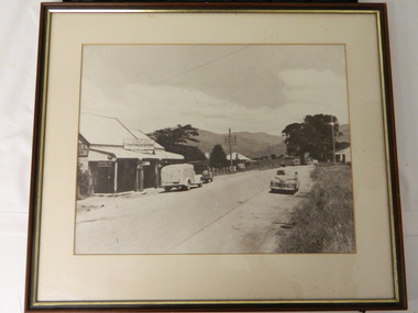
Photo - Tawonga Store
This photo was taken in the 1950's when Pearce Bros. owned the Tawonga Store. I.R.Northey's van is parked outside the store. Kodak photos are advertised. The Bakery existed. The road is sealed and telephone and electric wires are shown. The Pearce Bros owned the Tawonga Store in the 1950s when the population of the area in the Upper Kiewa Valley and High Plains was high due to the construction of the Kiewa Hydro Electric Scheme by the State Electricity Commission of Victoria.Sepia photo of Pearce Bros. Tawonga Store including a house next door, cars in the sealed street and part of the Bakery opposite. It has a slim wooden frame & white cardboard border. It has a clear glass cover. The back is lined with brown paper with a white cord across for hanging the photo.tawonga store. pearce bros. tawonga bakery. i.r.northey. -
 Greensborough Historical Society
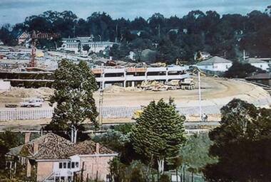
Photograph - Digital image, Greensborough Plaza under construction, 1977-1978
This view shows early construction phase of Greensborough Plaza in early 1978. Multi story carpark is shown from what is now The Circuit. The old Alwyn Farm house in the foreground were sporting clubrooms at the time.Digital copy of colour photographgreensborough plaza -
 Halls Gap & Grampians Historical Society
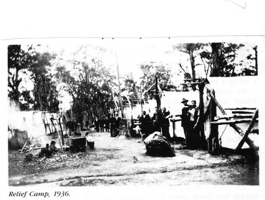
Photograph - Photocopy, C 1936
The relief workers as shown in the photograph were used in the Grampians for logging & road maintenance. After the Depression many hundreds of men worked on building and maintaining roads &: tracks. Some were employed by the Forest Commission of Victoria.people, road gang, structures, tents -
 Newcomb Secondary College Archives
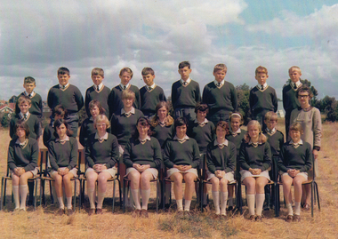
Photograph - Newcomb High School 1969 Class 1A, 1969 - Class 1A
Photograph shows one of three original classes, all of Form 1 students (approximately 12 years of age). The original summer uniform is worn by both girls and boys. Staff member shown is Rose O'Connell.Photograph, colour, of 3 rows of students, taken on the Newcomb Secondary College oval.newcomb secondary college, 1969, first class of students. -
 Lakes Entrance Regional Historical Society (operating as Lakes Entrance History Centre & Museum)
Photograph, Lakes Post Newspaper, 1/03/1996 12:00:00 AM
Also a black and white photograph taken at the same time at New Works Jetty another R I B shown in distance Nine members were involved in training 04877.1 10 x 15 cmBlack and white photograph of Cpl Amir Tito Mick Allen and Giz McKechnie of Australian Army training in a Rigid Inflatable boat on Cunninghame Arm Lakes Entrance Victoriamilitary history, people, r a a f, world war 1939 - 1945 -
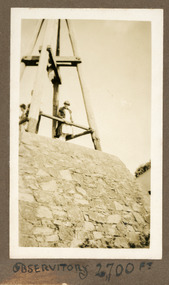 Mt Dandenong & District Historical Society Inc.
Photograph
The structure shown is the Mt Dandenong Observatory, also the Trig Point at the top of Mt Dandenong. It was a popular viewpoint and walking destination. The SkyHigh Restaurant now stands on this location. The photograph was taken by Ivy Child in the late 1920s.Sepia coloured photograph showing two people standing on top of a stone work structure below a wooden pyramid structure.Written below photograph in album - OBSERVITORY 2700FT.observatory, mt dandenong, trig point, ivy child -
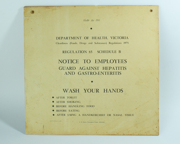 Vision Australia
Sign - Image, Wash Your Hands
These signs were printed and placed on to chip board for display in the kitchen area (as shown by the screw marks in the top corners). Brown marks and heat damage were most likely caused by their location in the kitchen at Ormond Hall.2 digital images of Department of Health Regulation 85 around cleanlinesssignage, ormond hall, royal victorian institute for the blind -
 Heidelberg Golf Club
Photograph - Framed Photograph, Pro-Am past winners 2017: Heidelberg Golf Club, 2017
Pro-Am past winners 2017: Heidelberg Golf Club Pro-Am sponsored by Get Wines Direct. Ladbroke PGA Pro-Am series. Winners shown on this photograph: 2017 winner Simon Hawkes.One of a set of framed photographs celebrating the winners of the Heidleberg Pro-Am.Colour photo and matt under glass in black timber frame.heidelberg golf club, heidelberg pro-am -
 Heidelberg Golf Club
Photograph - Framed Photograph, Pro-Am past winners 2018: Heidelberg Golf Club, 2018
Pro-Am past winners 2018: Heidelberg Golf Club Pro-Am sponsored by Get Wines Direct. Ladbroke PGA Pro-Am series. Winners shown on this photograph: 2018 winner Mathew Perry.One of a set of framed photographs celebrating the winners of the Heidleberg Pro-Am.Colour photo and matt under glass in black timber frame.heidelberg golf club, heidelberg pro-am -
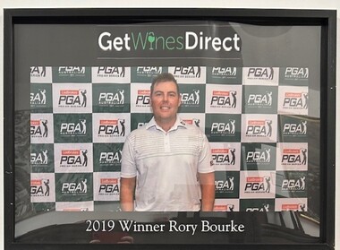 Heidelberg Golf Club
Photograph - Framed Photograph, Pro-Am past winners 2019: Heidelberg Golf Club, 2019
Pro-Am past winners 2019: Heidelberg Golf Club Pro-Am sponsored by Get Wines Direct. Ladbroke PGA Pro-Am series. Winners shown on this photograph: 2019 winner Rory Bourke.One of a set of framed photographs celebrating the winners of the Heidleberg Pro-Am.Colour photo and matt under glass in black timber frame.heidelberg golf club, heidelberg pro-am -
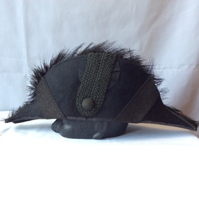 Hobsons Bay City Council
Bicorn Hat, Circa pre 1880
This hat was part of the ceremonial dress of Williamstown Mayors. It is evident in early photographs of Williamstown Mayors from circa 1880 to the 1920's. The hat is designed to be folded as is often shown carried under the arm in Mayoral portraits.The hat is significant as an example of Mayoral ceremonial dress and is documented in Mayoral portraits associated with Williamstown Council.Black beaver fur bicorn ceremonial hat with silk brocade and ostrich feather trim. Silk lined. -
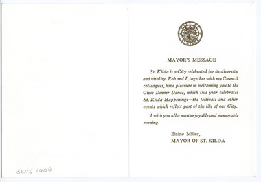 St Kilda Historical Society
Ephemera - Menu, Civic Dinner, late 1980s (est)
Menu for a civic dinner dance hosted by the City of St Kilda (Mayor Elaine Miller). No date is shown but it is estimated to be in the late 1980s. Elaine Miller served as Mayor in 1982-83, 1987-88 and 1988-89,Folded white card embossed on the front in gold, with St Kilda logo, and printed on the back in gold city of st kilda, civic dinners, st kilda mayor elaine miller -
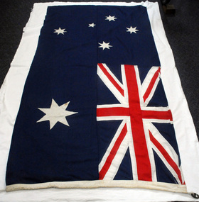 Orbost & District Historical Society
flag, 1960/1970's
This flag was used by St Joseph's School, Orbost at assemblies. St Joseph's Catholic School in Orbost was planned from 1913 when the town's population was increasing rapidly. It wasn't until 1923 that the school was built in Raymond Street next to St Colman's Church. Fifty-five students were initially enrolled and taught in two rooms. When the numbers increased to 170 work began on extensions which were completed in 1959. St Joseph's school had classes to Form 4 at one stage. Later on Form 2 was the highest level. However, after Nagle College at Bairnsdale built a new school on the Lindenow Road site, a Nagle College school bus ran from Orbost and the school was reduced to Grade 6. It was also about this time that the last of the St Joseph teaching nuns left Orbost. From 1969 to the early 1980s the secondary St Joseph students attended Orbost High School for the practical subjects of Woodwork and Home Economics. Today enrolments reflect the declining population of the district. This item is an example of an item used in an Orbost school in the second half of 20th century.A cloth Australian National Flag which has a blue background. The Union Jack is in the upper left corner. Below the Union Jack is a white Commonwealth Star. The Southern Cross is shown on the right hand side of the flag in white. There is a white rope and two metal clips inserted into the left hand pocket/seam.Inside a diamond is N.V. BRAND. Geo. PICKERS Co. P/L CANVASflag-australian st-joseph's-school-orbost heraldry -
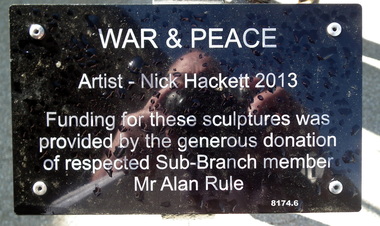 Bendigo Military Museum
Sculpture - WAR & PEACE FIGURES, Nick Hackett, C.2013
This display is situated on the RH side of the front entrance to the Bendigo District RSL in Havilah RoadSix metal sculptures representing the. Australian Army, Navy, Airforce, Women in the Forces over time during War & Peace. Consists of 4 figures standing, 1 kneeling with a child standing. Plaque black colour on a stand with white text re the Artist and Donor. The dimension shown is an average of the standing figures.As per the photo of the plaque.brsl, smirsl, bdrslinc, sculpture -
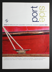 Mission to Seafarers Victoria
Journal, Port Side - Issue 3 Melbourne Port Corporation Community Newsletter Autumn 2003, 2003
Port Side is a local publication of eight-pages The front cover is white with a photo depicting part of a red, moored vessel. The third page, shown above, features a sketch of the Mission, two small photographs of the Mission buildings, the Mission logo and an article about the Mission to Seafarers and the Mission's Flying Angel Club.non-fictionmelbourne ports, mission to seafarers victoria -
 Bendigo Historical Society Inc.
Document - RAILWAYS COLLECTION: STEPHENSON LOCOMOTIVE NAMED BENDIGO
Railways collection Photocopied A4 re article on Stephenson locomotive named Bendigo extracted from The Australian Historical Railway Society Bulletin No. 487 - May 1978.The article has a photo of a Stephenson - built 2-4-0 Loco (see 6857) this photo is shown with the caption Contractors (Bruce & Cornish).magazine -
 Bendigo Historical Society Inc.
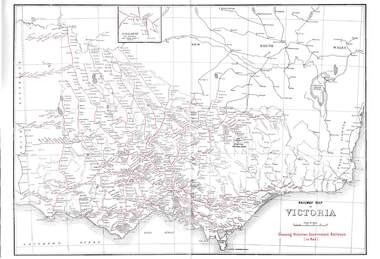
Map - RAILWAYS COLLECTION: 1946 RAILWAY MAP OF VICTORIA AUSTRALIA, 1946
Railways Collection-1946 glossy paper Railway Map of Victoria Australia Reproduced courtesy of V/Line by the Railway Museum North Williamstown Victoria 1988 price 3 pence. The maps shown are Railway Map of Suburban Lines Melbourne and Railways map of Victoria Showing Victorian Government Railways in red.map, victoria -
 Whitehorse Historical Society Inc.
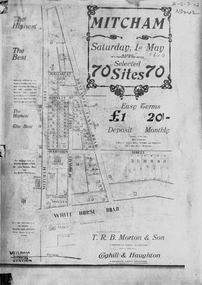
Document, Mitcham, ca 1920
Brochure for auction of 70 sites bounded by Mitcham, Doncaster East and Whitehorse Roads on 1 May ?1920.Brochure for auction of 70 sites bounded by Mitcham, Doncaster East and Whitehorse Roads on 1 May ?1920. Agents: T.R.B. Morton & Sons, Coghill & Haughton.|The home/hospital shown on brochure in Harrison Street near Mitcham Road owned by Dr Drake and later Dr Cochrane was called 'Coombe-Wood'Brochure for auction of 70 sites bounded by Mitcham, Doncaster East and Whitehorse Roads on 1 May ?1920.auctions, doncaster east road, mitcham, whitehorse road, mitcham road, mcdowall street, burnett street, t.r.b. morton & son, coghill & haughton, william street, harrison street, drake, francis, john, dr -
 Bayside Gallery - Bayside City Council Art & Heritage Collection
Photograph, Department of Crown Lands and Survey, Victoria, Brighton, Brighton East and Bentleigh, c. 1965-71
The Department of Crown Lands and Survey (1857-1983) was responsible for the administration of survey and mapping and the sale, occupation and management of crown land throughout its existence. This aerial photograph shows parts of Brighton, Brighton East and Bentleigh and was taken circa 1965-71.brighton, department of crown lands and survey, aerial photograph, bayside, port phillip bay, map, cartographic material, bentleigh, brighton east, dendy park, dendy street, centre road, nepean highway, south road, football -
 Kew Historical Society Inc
Photograph - Yarra Valley Floods: Kew East, 1916
Flooding of the Yarra Valley, including that section of the Yarra bordering Kew and Kew East in the north and west of the municipality, was a regular occurrence. Extreme flood events of the Yarra River are recorded to have occurred in 1891, 1901, 1916, 1923 and 1934. The Municipality of Kew's response to these floods was to enact planning decisions restricting residential development in flood prone areas following the floods of 1916, 1921 and 1934. While floods continued after the development of the Upper Yarra Reservoir (construction 1948-57), the regularity and extent of these inundations diminished. During the nineteenth century, the land abutting the south side of the Yarra in Kew was devoted to dairy farming. In the twentieth century, before and after the construction of the Eastern Freeway, much of this low-lying area was used as golf courses and public parks.One of a collection of photographs of flooding in the Kew section of the Yarra Valley which are in important research resource for the location and extent of flooding in the first half of the twentieth century. Flooding of the Yarra Valley at East Kew in 1916. The view is taken from a street (maybe Birdwood Avenue) intersecting with Kilby Road looking northeast across the flood waters to Ivanhoe and Heidelberg. The extensive flooded area shown in the photograph would have included remnant dairy farms and the Kew Golf Club. Verso: "Floods / Yarra River / East Kew / Kilby Road / 1917? / 87"yarra river, yarra valley, floods -- kew, kilby road -- kew (vic.), kew golf club -
 University of Melbourne, Burnley Campus Archives
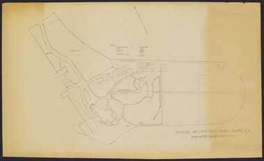
Plan - Sketch, School of Horticulture - Burnley, 1957
A,B,C,E paper copies, D, tracing paper copy of plan. Hand drawn sketch of central area of grounds. Figures given for acreage of ornamentals, crops and grazing although only 1 acreage is shown on plan. (E) has further annotation. Scale 1 inch:40 ft.burnley gardens, ornmental, crops, grazing, burnley school of horticulture -
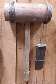 Mont De Lancey
Tool - Maul and Wedge, Unknown
Used in the 19th CenturyA large handmade wooden barrel shaped headed maul with two steel bands at each end and a wooden handle. It was used to split logs or timber particularly hardwoods using a wedge as shown in the media photo. The rectangular steel wedge has a pointed end which is damaged. It was used in the late 19th Century. mauls, striking tools, steel, wood, tools, splitting wedges, wooden mallet, woodworking tools -
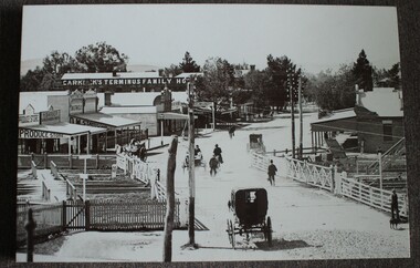 Wodonga & District Historical Society Inc
Photograph - Carkeek's Terminus Family Hotel, Wodonga, c1890
The Terminus Hotel, Wodonga was built by James Thompson Hatch in 1873, the same year the railway reached Wodonga from Melbourne. It was named due to its close proximity to the railway terminus. It was sold to Messrs George Day and Kenneth McLennan of Albury. It was first licenced to J.G. Morton in January 1874. Annie Allen, from Ireland, took over as licensee of the hotel containing 14 rooms in 1879, after she and her husband, George James Allen, purchased it. In 1887 they added a new wing on the south boundary of the property next to Peter McLean’s store at 81 Sydney Road. The architects for the new wing were Gordon and Gordon. A billiard room, a dining room, and 18 other rooms were added on the vacant block of land between the Hotel and the Bank of Victoria. A balcony 6 feet wide was added on the north side. Included in the plans was the latest patent elevator, later known as a dumb waiter. Allen died in 1889 aged 52, and Annie Allen continued to run the Terminus. She later married John G. Haldon and was licensee of the hotel until December 1898 when the licence was transferred to William Carkeek. Carkeek, from Cornwall, arrived in the colony around 1860 and is considered one of the founders of Tallangatta. In November 1903, the license was transferred to Daniel Crawford, then in 1906 it was transferred to Mr Stephen Carkeek. In 1916 it passed into the hands of Mr H. W. Allen of Rutherglen, son of Mr George James Allen. On 1st June 1998 the Terminus Hotel was destroyed by fire. Estimates of damage range from between a conservative $750,000 to as high as $2 million. The remains of the building were demolished in 1999.The Terminus Hotel was one of the earliest hotels in Wodonga with clear links to the establishment of the railway line. It was an important business and meeting place for social gatherings.A black and white image printed on canvas. The image includes Carkeek's Terminus Family Hotel in Sydney Road, now named High Street, Wodonga, Victoria. Other businesses shown include a produce store, D.M. Staveley Taylor, John Whan General Store. The railway track can be seen in the foregrounc.Across side of building "CARKEEK'S TERMINUS FAMILY HOTEL" On bottom left "High Street Wodonga 1890s"carkeek, terminus hotel, hotels wodonga -
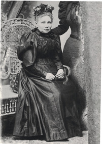 Linton and District Historical Society Inc
Photograph, Mrs. Nicol
Black and white copy of original photograph showing an older lady sitting on a decorative wicker bench, wearing a floral hat, dark dress with puff sleeves and high neckline. Dark embroidery on her bodice, her hands resting on her lap, with the side of another lady shown standing to her left.nicol family, portrait -
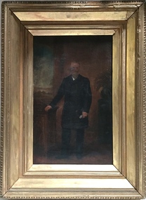 Kew Historical Society Inc
Painting - John Halfey, c.1882
John Halfey (1825-89) was born in Southport, Lancashire and migrated to Victoria in 1852. After finding gold at Sandhurst, and representing the latter in the Victorian Parliament, he moved to Melbourne to engage in various commercial pursuits, including directorships of insurance, mining and banking companies. A resident of Kew from the late 1850s, he was known for the hospitality provided at his house Ordsall (later Southesk) in Cotham Road. On 14 December 1860, Halfey chaired a public meeting calling for separation from the Boroondara Roads Board, which led, four days later, to the proclamation of Kew as a separate municipality. He was elected to the Council in 1861, replacing Cr. Oswin, and subsequently served as the second Chairman of the Municipality in 1862-1863. John Halfey became a trustee of Holy Trinity Church in Bulleen Road (now High Street) in 1862. He was to resign from Council after four years in 1865. Twenty-four years later in January 1889, he died aged 63 from a seizure, at his rooms at the Herald Office. He was interred in the Boroondara General Cemetery where his monument is the tallest in the Cemetery. Donated by Eileen Grigg, 2017Small, full-length portrait of John Halfey in an original gilded frame. The artist depicts him formally dressed in a frock coat beside an open window. He is shown holding a document or perhaps a pair of gloves. The painting is badly damaged with a hole in the area of his face that has been patched and repainted.john halfey, ordsall, chairman of kew, boroondara roads board, municipality of kew -
 Melbourne Tram Museum
Negative - Set of 8, Travis Jeffrey, Jun. 1960
1. B&W negative of tram 468 in Ballarat Rd Footscray. Tram has destination Explosives Factory. Driver stepping down from cab and passenger walking from tram to kerb. 2. B&W negative of tram 468 in Ballarat Rd at Gordon St Footscray. Tram has destination Railway Station. Tram shelter shown in front of Powell Hotel. 3. B&W negative of tram 468 in Gordon St Footscray. Tram has destination Railway Station. Tram is shown at corner of River St on wrong side of road, so appears to be ready for shunting. 4. B&W negative of tram 468 at Ordnance Factory West Maribyrnong. Tram has destination Ordnance Factory. W2 454 is in background. 5. B&W negative of tram 468 in River St Footscray. Tram has destination Explosives Factory. 6. B&W negative of tram 468 in Raleighs Rd West Maribyrnong. Tram has destination Explosives Factory. Tram is shunting. 7. B&W negative of tram 468 in Somerville Rd Footscray. Tram has destination Russell St. Tram is shown with driver and female conductor posing for photographer. 8. B&W negative of tram 468 at Ordnance Factory West Maribyrnong. Tram has destination Explosives Factory. 2nd unidentified Tram is shown in background. Female conductor walking the trolley pole around. NOTE: - dates are not as marked on some photo envelopes recorded below as the Footscray closed March 1961.1. Paper folder that contained the negative had "NR30A" written in red ink, "F9" written in pencil, "20A" written in blue ink, and date stamped 11 Jun 1960. On rear, dates stamped 26 Sep 1962 (twice). 2. Paper folder that contained the negative had "NR36A" written in red ink, "F8" in pencil, "26A" in blue ink, and date stamped 11 Jun 1960. On rear, dates stamped 26 Sep 1962 and 6 Oct 1962. 3. Paper folder that contained the negative had "NR47A" written in red ink, "F10" in pencil, "37A" in blue ink, and date stamped 23 Sep 1961. 4. Paper folder that contained the negative had "NR32A" written in red ink, "F14" in pencil, "22A" in blue ink, and date stamped 11 Jun 1960. On rear, dates stamped 26 Sep 1962 and 6 Oct 1962. 5. Paper folder that contained the negative had "NR54A" written in red ink, "F15" written in pencil, "44A" written in blue ink, and date stamped 28 Sep 1961. On rear, dates stamped 26 Sep 1962 and 6 Oct 1962. 6. Paper folder that contained the negative had "NR56A" written in red ink, "F13" in pencil, "46A" in blue ink, and date stamped 28 Sep 1961.2. 7. Paper folder that contained the negative had "NR64A" and "NR105A" written in red ink, "F11" in pencil, "64A" in green ink, and date stamped 1 Jan 1963. On rear, date stamped 26 Sep 1962. 8. Paper folder that contained the negative had "NR62A" written in red ink, "F12" in pencil, "52A" in blue ink, "damaged" in purple ink, and date stamped 11 Jun 1960.trams, tramways, x1 class, footscray, ballarat rd, gordon st, ordnance factory, somerville rd, trolley poles, crews, drivers, conductors, tram 468, tram 454 -
 Ringwood and District Historical Society
Flyer, Subdivisional Land Auction Sale Brochure, Grand Central Estate, Ringwood, Vic. - 1925
Douglas Street shown in the estate plan did not eventuate, but was developed as a public reserve. Refer also to Reg. No. 5149 for 1924 auction sale of land also titled Grand View Estate situated further north in Ringwood.Double sided multi-folded page advertising public auction sale on Saturday, 31st October, 1925, of residential allotments highlighting local facilities, services and layout of the estate. Includes panoramic view of Ringwood and other local photographic images.Subdivision includes Great Ryrie Street, Heathmont Road, Douglas Street, Garden Street, and Bellevue Avenue. Agents - Knight & Harwood, 315 Collins Street, Melbourne, Phone 10615, 10616 Central, in conjunction with J.B. McAlpin, Opposite Railway Station, Ringwood. Phone Ringwood 7. -
 City of Moorabbin Historical Society (Operating the Box Cottage Museum)
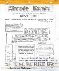
Flyer - Kinrade Estate, Bentleigh East
Kinrade Estate was not subdivided as shown in flyer. The land was purchased by Cyclone in 1950. Cyclone built a factory which manufactured wire material. This factory was closed in XXXX and a development firm purchased the land and subdivided the land into housing blocks.Example of the progress of the Municipality of MoorabbinAdvertising flyer for auction of real estate sales - plan of building blocks for saleleary avenue, charles street, peter leary, john joseph kinrade, tucker road, east boundary road, clover estate, kinrade estate, bentleigh, cyclone company, ardena court, bentleigh east -
 Port Melbourne Historical & Preservation Society
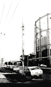
Photograph - Graham Street towards Albert Park, Reverend Donald LANGFORD, June 1973
Taken from the corner of Seisman Place looking towards Albert Park, the photograph was taken before the demolition of the gasometer shown on the on right. The original Albert Park High School can be seen behind the Pickles Street sign.B & W photograph of Graham Street, Port Melbourne looking towards Pickles Street.built environment - demolition, built environment - industrial, transport - roads, education - secondary schools, gasometer -
 Stawell Historical Society Inc
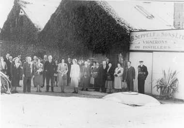
Photograph, Seppelts opening of new drive 1950
Photo of people at Seppelts & Sons cellars, Great Western. The official opening of the new drive which bears the name of Sir Dallas Brooks who is shown in the front row 4th from left. 13/4/1950winery, wine