Showing 10763 items
matching site
-
 Falls Creek Historical Society
Document - Application Of Rating - Account For Lodge Or Site
Bob (Herman) Hymans (a former member of the Royal Netherlands Navy) was born in Bloemendaal, Holland on 30th September 1922. During World War II he fought against the Japanese in the Dutch East Indies (now Indonesia) and was imprisoned in Changi and on the Burma Railway. After gaining qualifications as a Ski Instructor, Bob arrived in Falls Creek in July 1950. Working as an Instructor and Supervisor at Bogong Lodge, Bob decided his future was in accommodation. He was successful in negotiating an indenture for land from the State Electricity Commission (SEC). It took Bob two years to build his Grand Coeur Chalet but, tragically, it was burned down in August 1961. Bob also built the first Chairlift in Australia. This was a single chairlift and the structure was built from wooden electricity poles. He was constantly full of new ideas and proposals for the village. Bob Hymans died on 7th July 2007. This Collection of documents and letters tells the story of Bob's endeavours to develop Falls Creek into the ski village it is today.This item is significant because it documents actions taken by the Falls Creek Tourist Area Management Committee in their role overseeing the Tourist Area.A circular from the Management Committee accompany the rating notice for payments due no later than 31st October 1964falls creek tourist area management committee, falls creek administration, parking regulations falls creek -
 Falls Creek Historical Society
Document - Application For Lease Of Site Selected By S.E.C
Bob (Herman) Hymans (a former member of the Royal Netherlands Navy) was born in Bloemendaal, Holland on 30th September 1922. During World War II he fought against the Japanese in the Dutch East Indies (now Indonesia) and was imprisoned in Changi and on the Burma Railway. After gaining qualifications as a Ski Instructor, Bob arrived in Falls Creek in July 1950. Working as an Instructor and Supervisor at Bogong Lodge, Bob decided his future was in accommodation. He was successful in negotiating an indenture for land from the State Electricity Commission (SEC). It took Bob two years to build his Grand Coeur Chalet but, tragically, it was burned down in August 1961. Bob also built the first Chairlift in Australia. This was a single chairlift and the structure was built from wooden electricity poles. He was constantly full of new ideas and proposals for the village. Bob Hymans died on 7th July 2007. This Collection of documents and letters tells the story of Bob's endeavours to develop Falls Creek into the ski village it is today.This item is significant because it documents proposals put forward by Bob Hymans to develop facilities in the Falls Creek Tourist Area.A letter of application from Mr Hymans for the lease of land offered by the State Electricity Commission to develop a tourist hotel. His hotel would provide accommodation for 100 guests. It would contain a dining-room seating 140 and cater for guests and day-visitors. Other facilities included a lounge, public-bar and lounge-bar facilities. A private lounge for reception would also provide guest and convention facilities. His project was designed as a year-round resort hotel. As well as serving as a winter sports hotel, the plan featured indoor facilities including a heated swimming pool, squash courts, bowling alley and sauna bath. Stables, a tennis court and boats would also attract year-round tourism. The budgeted cost was £130,000 plus bowling alley equipment. He planned that construction would commence in October, 1963 and be completed in June, 1965.falls creek tourist area management committee, hymans' hotel plans, falls creek development -
 Ballarat Heritage Services
Photograph, General View of Canberra, the Federal Capital Site
Scene of Canberra, Australiacanberra -
 Ringwood and District Historical Society
Photograph, Maroondah Highway Central, Ringwood. Eastland car park on former site of Ringwood oval off Ringwood Street, c.1968
Black and white photographWritten on back of photograph, "Car park Eastland - soon after it started." -
 Buninyong & District Historical Society
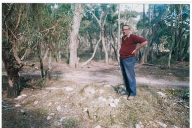
Photograph - Chinese graves, Misery Creek, Enfield, Chinese heritage site
Local history and evidence of Chinese heritageLocal history of Chinese miningGood condition with no blemishes or marksNonechinese grave sites, evidence of chinese mining activity in area, local mining history -
 Ballarat Heritage Services
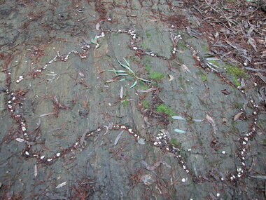
Photograph - School, Australia outlined in stone at the site of the Former Dry Diggings State School, 2004, 05/08/2004
This school opened as a common school in 1871 and was originally called Dry Diggings and it replaced Dry Diggings School (No.725), which closed in 1869. The first head teacher was Henry Humffray. There were 40 students when the school opened. The timber schoolhouse had a shingle roof and pine floor. It had been moved from Dry Diggings School. There were 77 students at the school in 1873. A house was built for the teacher in 1874. It had 4 rooms, a veranda, and a shingle roof. The school became a state school at some stage between 1873 and 1878.Four colour photographs showing a carved Australia into rock in the former Dry Diggings Primary School playground.dry diggings, education, schools, dry diggings state school, australia, rock art, henry humffray -
 Ringwood and District Historical Society
Photograph, Site of proposed lily pond at 'Quambee', North Ringwood, about 1912
Sepia photographWritten on back of photograph: "Future lily pond at 'Quambee', Nth Ringwood." -
 University of Melbourne, Burnley Campus Archives
Plan, City of Richmond Development of Old Burnley School Site, c. 1986
Plan for Park - area bounded by Madden Grove, Parkville, Stawell and Gibdon Streets Richmond. Scale 1:200. CP-72047186.richmond, burnley, burnley school, parks, golden square bicentennial park -
 Buninyong & District Historical Society
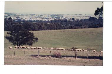
Photograph - Colour photograph of the site of the future B.I.A.E. at Mount Helen, Photograph shows the future site as an open paddock in 1968, with a herd of sheep and a distant view of Buninyong
Rural life landscape, future townscape.Slightly faded colour photographNonesite of what became federation univercity ., rural landscape -
Stawell Historical Society Inc
Archive, Register of Residents Area 21/8/1878 - 17/8/1882 and 1934 - 1936
Records of Residents. Site Occupier, Miners Right 1878-1882 & 1934-1936Large brown Ledger Book Red Leather Spine Cover.RS2 (Residence Site)local government -
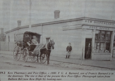 Kew Historical Society Inc
Print, FGA Barnard, Kew Pharmacy and Post Office, c.1880
The site of the current Kew Post Office was known as Barnard's corner. Large framed photographic enlargement of Barnard’s Post Office in Kew on the site of the Kew Post Office. The photograph is a copy of a photograph in F.G.A. Barnard's Jubilee History of Kew (1910)Annotation at base reads: 19.2 Kew Pharmacy and Post Office c .1880. F.G.A. Barnard, son of Francis Barnard is in the doorway. The site is that of the present Kew Post Office. Photograph taken from Bulleen Rd (now Kew High St) looking east.francis barnard, f.g.a. barnard, barnard’s post office, kew dispensary, pharmacies -- kew (vic.), post offices -- kew (vic.) -
Stawell Historical Society Inc
Archive, Register of Residents Area 12/1/1865 - 20/8/1878
Records of Residents. Site Occupier, Miners Right 12 Jan 1865 - 20 August 1878Large brown Ledger Book Red Leather Spine Cover, Crown on SpineRS1 (Residence Site)local government -
 Ringwood and District Historical Society
Newspaper, Scrapbook Clipping, Library Collection, Ringwood, Victoria
Newspaper Clipping from the ""Post", 24-1-96, P 1. "Hostel for school site", and P3 "New look likely for school site".A thirty bed aged nursing home facility will join the Ringwood Bowling Club at its new home on the former Norwood Primary School site in North Ringwood. Construction of both facilities commenced early in the new year, after the former bowling clib site was sold by Maroondah Council to Coles Myer on January 5 for over $5 million. -
Glenelg Shire Council Cultural Collection
Photograph - Photograph - Main Breakwater construction, Portland, 05/06/1659
Port of Portland Authority archivesFront: 5/6/59- Pencil Back: 5/6/59 - Pencilport of portland archives, main breakwater, construction, harbour development, site -
 Glenelg Shire Council Cultural Collection
Photograph - Photograph - wheat storage construction, Portland, c. 1970
Port of Portland Authority archivesFront: (no inscriptions) Back: Dragline on southern trench, wheat site/ June 11th (pencil, upper left)port of portland archives -
 Kew Historical Society Inc
Photograph - Historic re-enactment during the Festival of Kew, 1978
At the 1978 Festival of Kew, a number of organisations, including the City of Kew, the Kew Historical Society, Trinity Boys Grammar School and local Girl Guides participated in a re-enactment of the expedition of the party of Charles Grimes in surveying the Yarra River as far as Kew in February 1803. The location for the event was Yarra Bend Park near the Studley Park Boat House. The event was organised by the Kew Historical Society. The re-enactment was captured by a number of amateur photographers as well as by a photographer from the local Progress Press.Local communities select events to commemorate according to their shared history and values. Commemorations of colonial exploration were popular with local historical groups such as the Kew Historical Society in the twentieth century. In re-enacting events such as the Grimes survey of the Yarra, students from a local school were encouraged to take on specific roles, including play-acting individuals involved in the survey party as well as members of the local Wurundjeri People. The photographs, taken by amateur and professional photographers, represent a period in time when the dominant values were those shared by the descendants of European settlers in Victoria. Original colour photographic positive of the site where the re-enactment of Charles Grimes' survey party of 1803 took place during the Kew Festival of 1978.Annotated on reverse: "GRIMES LANDING SITE / 1978 / DONATED BY MRS DEAN"kew historical society, trinity grammar school, kew girl guides, city of kew, yarra river, charles grimes, collins expedition, wurundjeri people, yarra bend park, colonial surveys, historic re-enactments, festival of kew, kew festival -
Whitehorse Historical Society Inc.
Pamphlet, Creating a New Strathdon Community, 2001
Creating a New Strathdon Community.Creating a New Strathdon Community: A vision for the redevelopment of Strathdon's Jolimont Road site, contains Plans of Proposals for site development.Creating a New Strathdon Community.strathdon community, strathdon orchard, matheson, charles, matheson mary, aged people -
 Glenelg Shire Council Cultural Collection
Photograph - Photograph - wheat storage construction, c. 1970
Port of Portland Authority archivesFront: (no inscriptions) Back: Preliminary earthworks, wheat storage site/ June 4th (pencil, upper left)port of portland archives, wheat storage, portland harbour, construction -
 City of Moorabbin Historical Society (Operating the Box Cottage Museum)
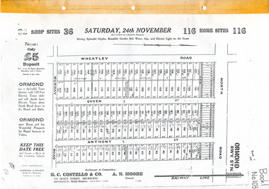
Flyer - Brennan's Estate, Ormond - H. C. Costello & Co, 1923 - 1924
Land sales in the Municipality of Moorabbin increased when the train line from the City to Frankston was electrified. Brennan's Real Estate, Ormond 116 home sites and 36 Shop sites was auctioned on three occasions in order to sell building lots that had failed to sell at the previous action.Example of the progress of the Municipality of MoorabbinAdvertising flyers for auction of real estate sales - plan of building blocks for saleBrennan's Real Estate, Ormond 116 home sites and 36 Shop sites was auction on three occasionsnorth road, wheatley road, queen street, anthony street, murray road, h. c. costello & co, a. n. moore, ormond, real estate, auctions -
 Kiewa Valley Historical Society
Plans - Southern Hydro - Bogong Power Development
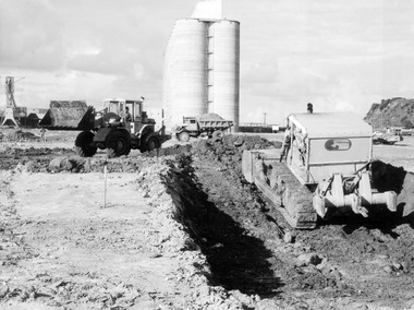
Southern Hydro owned the Kiewa Hydro Electric Scheme in May 2006 when these plans were created. The Site No. 1 and Site No. 2 are part of the Bogong Power Development Bogong Power Development is part of the Kiewa Hydro Electric SchemeLaminated A3 plans mostly black and white but with a little color and surrounded by a grid.(Also see KVHS 1439) 1. Tunnel and Civil works / Commissioners Lodge Site Plan 1: Site No. 1 / TBN /Water /Supply / Reservoir Site 2. Tunnel and Civil Works / Pedestrian Diversion Access Paths / and Tracks: Site No. 2 / Lake Guy Site / Bogong Victoriabogong power development, southern hydro 2006 -
Surrey Hills Historical Society Collection
Map, Contour map of Surrey Hills showing potential sites for the Telecom Tower
The PMG / Telecom / Telstra tower was built in 1961-1963 as a relay station to support television and radio links between city and regional broadcasting stations. The tower itself was 45 m in height with a 2 storey building for equipment and staff surrounded by garden. From the beginning it was opposed by local residents. The location is said to be the second highest site in Melbourne, sometimes described as Delaney's Hill.Two A3 photocopied sheets of a map showing part of Surrey Hills, roughly between Windsor Crescent and Belmont Street (north / south) and Standard Avenue and Balmoral Crescent (east / west). The map shows contour lines and house sites, 16 of which are numbered. One sheet has been inscribed in top RH corner with notes regarding the significance of the numbers."Contour map of potential sites / for the telecommunications tower which / was eventually sited at 2. / Jock Campbell OBE was our neighbour / at 4 Theodore St when we moved into / the area in 1984. He was responsible in his / job at the PMG in deciding on the /site of the tower - Note site 5 was / behind his (& our) house. / Jack ended his career as Deputy Director / of the PMG. He sat on international committees / after WW2 to decide the split of the electronic / spectrum for radio, TV etc. / His group developed a "mobile phone" using / fixed towers but the phone was a truck full of gear."contour map, telecom tower, maps, jock campbell, john duncan campbell -
 Mt Dandenong & District Historical Society Inc.
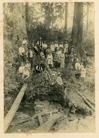
Photograph, Working Bee For Mt Dandenong School c1899, c1899
Photograph mounted on stiff cardboard showing a group of adults and children attending a working bee to clear a site for the Mt Dandenong State School which opened on April 23rd 1901 following the relocation of a building from Ringwood to the site. The original school operated from a rented building from 1897 that was opposite the present school site. NB: The attendees looked fairly well dressed for a working bee.Handwritten on back of photo: Working bee clearing site for Mt Dandenong State School years about 1899 - 1900 AD.mt dandenong school, working bee -
 Port of Echuca
Black and white postcard, Early 20th Century
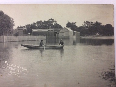
The gasworks in Anstruther St, allowed the streets of Echuca to be lit at night, therefore improving the safety of the citizens of the town. The gasworks were operational for many year providing cooking and lighting facilities to houses as well as to the streets. This picture shows the height of the flood in either 1906 or 1916? The Senior Citizens Club now stands on the site. The Central Kindergarten and Echuca Primary School are also nearby.This postcard is significant because it shows the height of the floods before the town levee banks had been built. It also shows the need for flood proofing the town. It also shows the size of the gasworks in the early 20th Century. The Senior Citizens Club is currently built on this site.A rectangular black and white postcard showing the gasworks in Anstruther Street, during a high flood, in either 1906 or 1916. The gasworks site is now the site of the Senior Citizens Club. A picket fence surrounds the gasworks and there are two men rowing a row boat passed the works in the flood water.On the front of the postcard in white hand writing are written the words 'Flood Water - Echuca.' On the back of the postcard the following words are printed. "W.Grimwood. Echuca. POST CARD. Correspondence. Address Only. Kodak Australia." Handwritten in pen are the words "Old Gasworks Anstruther Street. Now site Senior Citizens Club" Handwritten in pencil are the words "1906 or 1916"echuca gasworks., anstruther street, flooding, 1916, 1906, street lights, pullicino, j -
 Falls Creek Historical Society
Document - Hand-Written - Re Sites 4 & 4a. (Almost Indecipherable)
Bob (Herman) Hymans (a former member of the Royal Netherlands Navy) was born in Bloemendaal, Holland on 30th September 1922. During World War II he fought against the Japanese in the Dutch East Indies (now Indonesia) and was imprisoned in Changi and on the Burma Railway. After gaining qualifications as a Ski Instructor, Bob arrived in Falls Creek in July 1950. Working as an Instructor and Supervisor at Bogong Lodge, Bob decided his future was in accommodation. He was successful in negotiating an indenture for land from the State Electricity Commission (SEC). It took Bob two years to build his Grand Coeur Chalet but, tragically, it was burned down in August 1961. Bob also built the first Chairlift in Australia. This was a single chairlift and the structure was built from wooden electricity poles. He was constantly full of new ideas and proposals for the village. Bob Hymans died on 7th July 2007. This Collection of documents and letters tells the story of Bob's endeavours to develop Falls Creek into the ski village it is today.This item is significant because it documents proposals put forward by Bob Hymans to develop facilities in the Falls Creek Tourist Area.A response from Mr. Hymans in response to the release of information related to the design of the extension to Christie Street in Falls Creek. As a result he wished to apply for a long-term lease of each site. I am in receipt of a letter from the General Superintendent Kiewa of the 3rd of April 1964. It was to inform me that the creation of new sites divided (?) with a 50’ ski road between them in trees of Site 4. Consequently, I wish to apply through your Committee for long term leases for the two sites. Yours faithfully H. Hymansfalls creek tourist area management committee, bob hymans, falls creek administration -
Whitehorse Historical Society Inc.
Article, College Clean Up, 1/09/1993 12:00:00 AM
Old Orchard Primary School Community cleans up siteOld Orchard Primary School Community cleans up site of old Blackburn Secondary College in readiness for the Primary School's move to the site.Old Orchard Primary School Community cleans up site old orchard primary school, blackburn secondary college, atkinson, bruce, abbott, kevin, harris, margaret, nash mike -
Glenelg Shire Council Cultural Collection
Functional object - Brick fragments from the site of William Dutton's House, Portland, c. 1840
Brick fragments came from the site of Dutton's House. Made locally. Displayed at History House.Bricks from site of Dutton's house.william dutton, portland history, maritime, whaling, sealing -
Whitehorse Historical Society Inc.
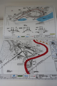
Article, Tunnel vision, 2005
Article on the progress of excavation works on Eastlink's Mullum Mullum Valley tunnel, and the visit of Premier Steve Bracks and Transport Minister Peter Batchelor to the site.Article on the progress of excavation works on Eastlink's Mullum Mullum Valley tunnel, and the visit of Premier Steve Bracks and Transport Minister Peter Batchelor to the site. Photos of site and visitors.Article on the progress of excavation works on Eastlink's Mullum Mullum Valley tunnel, and the visit of Premier Steve Bracks and Transport Minister Peter Batchelor to the site. eastern freeway extension, mullum mullum creek, eastlink -
 Northern District School of Nursing. Managed by Bendigo Historical Society Inc.
Photograph - Mayfort House
The Northern District School of Nursing opened in 1950 in to address the issues around nurse recruitment, training and education that had previously been hospital based. The residential school was to provide theoretical and in-house education and practical training over three years. The students would also receive practical hands-on training in the wards of associated hospitals. The Northern District School of Nursing operated from Lister House, Rowan Street, Bendigo. It was the first independent school of nursing in Victoria and continued until it closed in 1989.B&W photograph of Mayfort House, nurses' accommodation, 148 Wattle Street, Bendigo. Now demolished, site of present-day car park.Mayfort House, nurses' accommodation, 148 Wattle Street, Bendigo. Now demolished, site of present-day car park.ndsn, nursing -
 Kilmore Historical Society
Photograph, 69 Sydney Street, 1982
Was the site of Thomas Phillips' Forge8.5cm x 12.5cm coloured photograph of the construction of the Forge Restaurant at 69 Sydney Street. This was the site of the Thomas Phillips' Forge and is currently the site of Kilmore Palace Chinese Restaurant.restaurants, construction, construction sites -
 Ringwood and District Historical Society
Newspaper, Scrapbook Clipping, Library Collection, Ringwood, Victoria, `
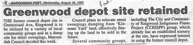
``Newspaper clipping from "The Post" 16-8-95 P 6 Greenwood depot site retainedThe former council depot site in Greenwood Ave, Ringwood is tio be utilised by a variety of local community groups and as a dump for street sweepings, Maroondah council decided this week. `