Showing 668 items matching "survey plan"
-
 Bendigo Historical Society Inc.
Document - Geological Survey of Victoria, Hustlers Line of Reef, Bendigo, April, 2014
Seven men were killed at the Great Extended Hustler's mine disaster on 2nd May 1914 by an explosion of dynamite occurring as the men were waiting at the plat to ascend the mine at the end of their shift. No blame was attached to anyone in the findings of the inquisition. It was unknown what caused the dynamite to explode. This document formed part of the research done at the time by Bendigo Historical Society, of the 100 years commemoration of the mine disaster, held at Hustler's Hill in 2014. Seven page photocopy of Department of Mines, Bulletin, Geological Survey of Victoria, Hustlers Line of Reef, Bendigo, No. 33 by H.S. Whitelaw. Includes plan of Hustlers Royal Reserve No. 2, (main shaft) showing location on Pall Mall, and location of Post Office and Law Courts; plan of location of Hustlers Royal Reserve No. 2 (Park Shaft) showing Jail (sic), Camp Hill State School, two 'lagoons' in between tennis court, croquet court and bowling green; a plan of the Great Extended Hustler's Shaft and two copied images of Hustler's Hill showing mining buildings, poppet heads and chimneys. Comet, K.K., Hustler's No. 1, Old Comet and United Hustler's and Redan Mines are shown in the images. great extended hustlers, goldmining, accident, quartz, mining, k.k. mine, comet mine, hustler's line of reef, old comet, united hustler's, redan -
 Bendigo Historical Society Inc.
Letter - MERLE HALL COLLECTION: ROSALIND PARK CREATIVE VILLAGE BENDIGO PROJECT LETTERS, 1995
MERLE HALL COLLECTION: ROSALIND PARK CREATIVE VILLAGE BENDIGO PROJECT LETTERS Merle Hall Collection: Rosalind Park Creative Village Bendigo Project Letters from Maery Hall (Gabriel). 6 December 1995 To: Merle Hall Arts Bendigo From Maery Hall Content: Outline of what is involved in the design and working of the project. Enclosed are three page of the design outline, one page of tool drawings, three sheets of sketches, photograph of small mosaic sketch using rocks I brought back from my last visit. The letter also contains: Materials, Tools, labour, other needs, Time, Costs and the Council’s role. 6 November 1995 To: Merle Hall Secretary Arts Bendigo From Maery Hall Content: Contains a rough sketch of the project. Note that the sketch is missing. 29 January 1997 To: Merle Hall Arts Bendigo From Maery Gabriel Content: Contains a drawing for the remaining pavement areas that I submitted before and measurements for the actual slabs for 22 square m. for the two. The result will be 2 (saddle reefs) in style. Also mentioned are two options for payment. Receipts also included for the last two payments and the saw. Thank you for sending the form of transfer for the saw. (Note the drawing is missing) 10 April 1997 To: Merle Hall Arts Bendigo From Maery Gabriel (artist in Mosaic) Content: Thank you for your letter of 9 March and further discussions on costs and layouts. 25 Feb 1997 To: Maery Gabrel, ‘Morningswood’ Peterson’s Road Ellinbank 3821 From Merle Hall Secretary Arts Bendigo Content: Apologies for the delay in not answering last letters and drawings. Mentions the need to meet with the Council to discuss the completion of the project and the need to enquire about funding from the Premier’s ‘community support fund’ 9 March 1997 To: Maery Gabrel From Merle Hall Secretary Arts Bendigo Content: Follow-up letter from 25 Feb 1997 concerning the last sections of the mosaic project. Outcome of meeting with Bernard Smith of the City of Greater Bendigo One local business sponsor prepared to donate a small amount towards completion of the project P.S. Sharon Hackett: the painter would love to receive her questionnaire from you. 22 Dec 1996 To: Maery Gabrel From Merle Hall Secretary Arts Bendigo Content: Enclosed is a form to cover transfer of ownership of the diamond saw as recommended by an adviser. P.S. the transfer is made out to ‘Hall’ - your name under our contracts. I’ve used your name for the address. 20 Dec 1996 To: Maery Gabrel From Merle Hall Secretary Arts Bendigo Content: Arts Bendigo Inc. of P.O. Box 563, Bendigo, 3552, agrees to the transfer of ownership to Maery Hall of ‘Morningswood’, Peterson’s Rd., Ellinbank, 3821 of one ‘Stubbie electric Bricksaw. Purchased from DEMBICON on May 25th, 1996 Diamond Blade for $1650, now valued at $1200 Part payment for the contractor of a mosaic pavement around the poppet lookout in Rosalind Park Bendigo. 30 Nov 1995 To: Maery Gabrel From Merle Hall Secretary Arts Bendigo Content: The enclosed survey sketches just arrived. Formal approval from the commissioners. Early next year the poppet head will be re-painted and have scaffolding there for a time but shouldn’t be a problem. 9 January 1996 To: Maery Gabrel From Merle Hall Secretary Arts Bendigo Content: Summary of discussions with the John Little V.A.C. and Roni Schell from ‘Future Connections’ re her DEET submission and Bernard King from the City and one of the Commisioners. A non-specific plan for being ‘contracted and not employed’ An expectation the ‘Future Connections’ would then offer you separate contract to conduct workshops for their clients and develop tutorials. 9 November 1995 To: Maery Hall From Merle Hall Secretary Arts Bendigo Content: Sketches enclosed for the poppet head site and comments on them from the City Council. 20 January 1997 From: Maery Gabiel Artist in Mosaic (formerly Maery Hall) To: Merle Hall Secretary Arts Bendigo Content: Receipt of $5000 plus one ‘Stubbie Electric Bricksaw, with stand, serial number 0002056 being payment under contract no. 2 for work on mosaic payments in Bendigo. 20 May 1996 List of Materials and equipment required for Mosaic and tools to be mademaery hall, arts bendigo -
 Bendigo Historical Society Inc.
Document - VICTORIA HILL - VICTORIA HILL AND NEW CHUM HILL
Typed notes on Victoria Hill and New Chum Hill. Notes give location, value of gold and plans for a mining museum.document, gold, victoria hill, victoria hill and new chum hill, john neil macartney, the age, the australasian, bendigo goldfields registry 1871, victoria reef quartz mine, north old chum, victoria consols, new chum and victoria, pioneer, lansell 222 mine, lazarus, barnet lazarus, mt. alvernia hospital, fortuna villa, george lansell, a. h. q. survey regiment, central red white and blue, hudsons, burrowes & sterry, b c v channel 8, bendigo and district tourist association, section 14 of the lands act 1958, mr a r richardson, cr t r flood, tourist association -
 Monbulk RSL Sub Branch
Book, Time-Life Books, The second front, 1977
... overlord Text and photographs survey the planning and execution ...Text and photographs survey the planning and execution of Operation Overlord, the Allied invasion of Germanoccupied Europe on June 6, 1944.Index, bib, ill, , maps, p.208.non-fictionText and photographs survey the planning and execution of Operation Overlord, the Allied invasion of Germanoccupied Europe on June 6, 1944.world war 1939-1945 - campaigns - western europe, operation overlord -
 University of Melbourne, Burnley Campus Archives
Plan, Plan of Richmond Park, 1872
... and Survey, 6th Sept. 1872. Plan of Richmond Park Plan ...Plan of Richmond Park L4461. Shows Horticultural Society's Garden without extra land used for Field Station (see 11.0363, but earlier). Surveyed and drawn by A.L. Martin, Authorized Surveyor. Photo-lithographed at the Department of Lands and Survey, 6th Sept. 1872.Handwritten notes on reverse and another railway line marked in pencil.railway lines, swan street, yarra river, richmond park, horticultural society, orchard -
 University of Melbourne, Burnley Campus Archives
Plan, Plan of Richmond Park, 1886-1948
(1) Black and white photographed copy of an original coloured plan. Plan of Richmond Park with Horticultural Society Gardens marked in. Includes additional land which became the Field Station. Original plan dated 31 August 1872, note of Crown Grant to the Board of Land & Works and Richmond City Council 1886; showing land, "Permanently Preserved for the Gardens". Stamp, "Department of Lands and Survey Photographed at the Central Plan Office 1/1 Plate 7.12.48" (2) Also 2 photocopies, 1 reduced - possibly used in a publication1 photocopy has "Figure 1. Plan of Burnley Gardens circa 1863 [sic]gardens, richmond, horticultural society of victoria, richmond park, a.l. martin -
 Bendigo Military Museum
Photograph - Detachment - Army Survey Regiment, Bonegilla, Victoria, c1973
This is a set of six photographs of personnel from the Detachment - Army Survey Regiment taken in front of its main map production building at Bonegilla, Victoria in c1973. This cartographic map production sub-unit of the Army Survey Regiment operated in buildings owned by the School of Military Survey from 17th of June 1970 to the 30th of September 1985. A total of 800 topographic maps ranging in scale from 1:25,000 to 1: 250,000 scale were completed. A major focus of production in the 1970s was the cartographic completion of the Papua-New Guinea 1:100,000 map series and the Flexiflow quality control system was developed as a tool to coordinate production. The Flexiflow system comprised a series of job plans and charts linked to a task allocation to resource magnetic planning board. Using critical path analysis and task prioritisation, complex job planning was efficiently scheduled, and re-prioritisations readily made. Reproduction requirements were effectively coordinated by way of weekly courier to the Army Survey Regiment at Bendigo. Supervisors and technicians fully embraced the system as they could understand their role, others around them and the positive production achievements. WO1 Bill Boyd (who does not appear in this photograph) was the technical warrant officer for 11 years at the Detachment was awarded the OAM, the Order of Australia Medal for leading the development and the implementation of the Flexiflow system. By mid-1982, production of maps at these scales was undertaken digitally on Bendigo’s AUTOMAP 2 system and the Detachment reverted to production of small-scale large format RAAF aeronautical charts. Detachment personnel managed to produce 18 charts in the following two years, which was an impressive achievement for the staff, given major differences in format, specification and scales. Development of digital production of aeronautical charts in 1984-85 led to gradual reduction in production output and contracting out production was instigated to meet the shortfall and as a consequence the Detachment closed in September 1985. See pages 177 to 180 of Valerie Lovejoy’s book 'Mapmakers of Fortuna – A history of the Army Survey Regiment’ ISBN: 0-646-42120-4. for more information on the history of the Detachment at Bonegilla.This is a set of six photographs of the Detachment - Army Survey Regiment taken in front of the main map production building at Bonegilla, Victoria in c1973. The photographs were printed on photographic paper and are part of the Army Survey Regiment’s Collection. The photographic print and proofs were scanned at 600 dpi. .1) to .3) - Photo, black & white c1973. Back Row L to R: Peter Simpson, Chris Edwards, unidentified (x2), Colin Harden, Rowan Gillies, Bob Rowley OAM, Steve Hansen, Stu Thaxter. Centre Row L to R: Kevin Boehm, Dennis McCarthy, Peter Cross, unidentified, Brian Ryan, unidentified, Ian Marner, unidentified, Phil Smalley. Front Row L to R: Geoff Haynes, Bruce Wetzig, Dave Thompson, unidentified, OC Bob Roche, Ike Lever, John McCulloch, Dick Barwald, unidentified. .4) - Photo, black & white c1973. Back Row L to R: Peter Simpson, Chris Edwards, unidentified (x2), Colin Harden, Rowan Gillies, Bob Rowley OAM, Steve Hansen, Stu Thaxter. Centre Row L to R: Kevin Boehm, Dennis McCarthy, Peter Cross, unidentified, Brian Ryan, unidentified, Ian Marner, Phil Smalley, unidentified, Dick Barwald. Front Row L to R: Geoff Haynes, Bruce Wetzig, Dave Thompson, unidentified, OC Bob Roche, Ike Lever, John McCulloch, unidentified (x2). .5) - Photo, black & white c1973. Back Row L to R: Geoff Haynes, unidentified, John McCulloch, Bruce Wetzig. Front Row L to R: Dave Thompson, Ike Lever, unidentified. .6) - Photo, black & white c1973. L to R: OC Bob Roche, unidentified.There are no personnel annotated.royal australian survey corps, rasvy, army survey regiment, detachment - army survey regiment, army svy regt, asr -
 University of Melbourne, Burnley Campus Archives
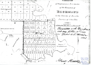
Plan - Photocopy, Sketch of the Proposed Boundaries of the Village of Richmond, 1843
Sketch of the proposed boundaries of the village of Richmond in the County of Bourke Parish of Jika-Jika. Handwritten on original: "Transmitted with Description and my letter No 43/150 Dated 11th November 1843 Robert Hoddle." Shows Burnley Gardens site as "Reserve. Survey Department." original in Central Plan Office, Department of Natural Resources and EnvironmentIn ink: From Central Plan Office Dept. Nat. Resources & Environmentrichmond, jika-jika, survey department, yarra river, robert hoddle -
 Bendigo Historical Society Inc.
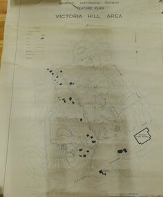
Map - VICTORIA HILL AREA
Contour plan of the Victoria Hill area, with all of the historical features marked and namedCompiled by AHQ Survey Regt. CMF increment May 1971map, reserves, mining, bendigo goldfield, victoria hill -
University of Melbourne, Burnley Campus Archives
Plan, Plan of the Melbourne Botanic Gardens, 1948
... . of Lands & Survey, Melbourne, March 1948. Plan of the Melbourne ...Partially coloured plan on a grid. Prepared from Field Notes of Survey by F.C. Ridoutt drawn and reproduced at the Dept. of Lands & Survey, Melbourne, March 1948.f.c. ridoutt, gardens, melbourne, royal botanic gardens melbourne -
 Bendigo Historical Society Inc.
Map - FRED COWIE COLLECTION: AERIAL MAPS OF HEATHCOTE/EPPALOCK, 28-9-1960
Map, Heathcote C2, Township of Heathcote, Melbourne Road through town branching off to Bendigo & Echuca. Aerial Survey of Victoria. Photo-map prepared by Department of Crown Lands and Survey from photographs taken in 1960. Copied photographically at the Central Plan Office.Fred Cowie,46 McIvor Rd,Bgo..Central Plan Officemap, heathcote, fred cowie -
 Bendigo Historical Society Inc.
Map - FRED COWIE COLLECTION: AERIAL MAPS OF HEATHCOTE/EPPALOCK, 28-9-60
Map, Heathcote C3, Aerial Survey of Victoria, Photo-map prepared by Department of Crown Lands and Survey from photographs taken in 1960.Copied photographically at the Central Plan Office. Date 28-9 60, C.P.O.Neg. No.21588.Campaspe River, Coliban River. Flower Hill. Fred Cowie,46 McIvor Rd.Bendigo (Not located 29.9.2022)Central Plan Office.map, heathcote, fred cowie -
 Bendigo Historical Society Inc.
Map - FRED COWIE COLLECTION: AERIAL MAPS OF HEATHCOTE/EPPALOCK, 28-9-60
Map, Heathcote C4, Aerial Survey of Victoria,Photo-map prepared by Department of Crown Lands and Survey from photographs taken in 1960. Copied photographically at the Central Plan Office.Date 28-9-60,C.P.O.Neg.No.21590.Scale 4 inches to 1 mile. Fred Cowie,46 McIvor Rd,Bgo..Central Plan Office.map, heathcote, fred cowie -
 Bendigo Historical Society Inc.
Map - HUSTLER'S REEF & HUSTLER'S REEF NO 1 MINES - PLAN OF THE HUSTLER'S REEF & HUSTLER'S REEF NO 1 MINES
... Survey of Victoria Plan of the Hustler's Reef & Hustler's Reef ...Plan of the Hustler's Reef & Hustler's Reef No 1 Mines on the Hustler's Line of Reefs, Bendigo Bulletin No 33, Plate No XIV. No 8 connecting No 10 (Hustler's Reef), No 11 connecting No 13 (Hustler's Reef), No 13 (Hustler's Reef No 1) connecting No 15 (Hustler's Reef) and No 10 Hustler's Reef No 1 rise to Comet Mine. Map shows different levels in relation to the two shafts, the lines of the Hustler's Line of Reefs and the Lightning Hill Line of Reefs, the approximate Boundary of Lease and the Comet Co., the adjoining lease. Table on the left shows the levels and their depths of the two mines. Signed by H A Whitelaw, Underground Survey Office, Bendigo, September 1913. Geological Survey of Victoria emblem. mining, parish map, hustler's reef & hustler's reef no 1 mines, hustler's line of reefs lightning hill line of reefs, comet co., h a whitelaw, underground survey office bendigo, geological survey of victoria -
 Bendigo Historical Society Inc.
Map - HUSTLER'S REEF & HUSTLER'S REEF NO 1 MINES - PLAN OF THE HUSTLER'S REEF & HUSTLER'S REEF NO 1 MINES
Plan of the Hustler's Reef & Hustler's Reef No 1 Mines on the Hustler's Line of Reefs Bulletin No 33, Plate No XVII. Two drawings with different levels on each for clarity. Shows depth and some geographical features. Geological Survey of Victoria emblem. Signed by H A Whitelaw Underground Survey Office Bendigo, September 1913. mining, parish map, hustler's reef & hustler's reef no 1 mines, hustler's line of reefs, geological survey of victoria, underground survey office bendigo, h a whitelaw -
 Bendigo Historical Society Inc.
Map - HUSTLER'S REEF & HUSTLER'S REEF NO 1 MINES - PLAN OF THE HUSTLER'S REEF & HUSTLER'S REEF NO 1 MINES
Plan of the Hustler's Reef & Hustler's Reef No 1 Mines on the Hustler's Line of Reefs Bulletin No 33, Plate No XV. Plan shows the two mines with depth of levels, geological features and levels in relation to the shaft. Geological Survey of Victoria emblem and signed by H A Whitelaw, Underground Survey Office Bendigo, September 1913. Note - The Lease Boundaries shown on this plan are only in their approximate relative positions to Nos 13, Intermediate and 14 Levels of the Hustler's Reef No 1 workings, and Nos 15, 16 and 17 Levels of the Hustler's Reef workings.mining, parish map, hustler's reef & hustler's reef no 1 mines, geological survey of victoria, underground survey office bendigo, h a whitelaw, hustler's line of reefs -
 Bendigo Historical Society Inc.
Map - HUSTLER'S REEF & HUSTLER'S REEF NO 1 MINES - PLAN OF THE HUSTLER'S REEF & HUSTLER'S REEF NO 1 MINES
... Office Bendigo Geographical Survey of Victoria Plan ...Plan of the Hustler's Reef & Hustler's Reef No 1 Mines on the Hustler's Line of Reefs, Bendigo Bulletin No 33, Plate No XVI. Plan shows the two shafts and the levels in relation to it. No 9 Level 896 feet 9 inches connecting No 10 Level at 867 feet 2 inches. Plan shows depth of levels and geographical features. Signed by H A Whitelaw, Underground Survey Office, Bendigo. Geographical Survey of Victoria emblem.mining, parish map, hustler's reef & hustler's reef no 1 mines, hustler's line of reefs, h a whitelaw, underground survey office bendigo, geographical survey of victoria -
 Bendigo Historical Society Inc.
Map - FORTUNA HUSTLER'S MINE - PLAN OF FORTUNA HUSTLER'S MINE
Map and plan of the Fortuna Hustler's Mine on the Hustler's Line of Reefs. Bulletin No 33, Plate No 1. Plan gives depth of the different levels. Bendigo Railway Station is on the map and also a number of the streets. Carpenter Street is called Cemetery Road. Also on the Hustler's Line of Reef is the Summer Hill Shaft. Shown is the Hustler's Royal Reserve No 2 Lease. Map has the Geological Survey of Victoria crest. It is signed by H Whit ? an Underground Survey Office Bendigo, September 1913. map, fortuna hustler's mine, hustler's royal reserve no 2 lease, summer hill shaft, hustler's line of reef -
 Bendigo Historical Society Inc.
Map - COMET MINE - LONGITUDINAL SECTION COMET MINE
Longitudinal section of the Comet Mine on the Hustler's Line of Reef Bulletin No 33, Plate No XXVI signed by H. S. Whitelaw, Underground Survey Office Bendigo, September 1913. Map shows datum lines, depths of levels, approximate boundaries and references to other plans. Note - Plates 4, 8, 13, 20, 26 and 31 form a Longitudinal Section from Fortuna Hustler's to Hustler's Consols Mine. Geological Survey of Victoriamining, parish map, hustler's line of reef, longitudinal section of comet mine bulletin no 33 plate no xxvi, h s whitelaw -
 Bendigo Historical Society Inc.
Map - COMET MINE - PLAN OF COMET MINE
... Geological Survey of Victoria Plan of the Comet Mine on the Hustler's ...Plan of the Comet Mine on the Hustler's Line of Reefs Bulletin No 33, Plate No XXIII. Map shows depths, Lightning Hill Anticline, Hustler's Anticline and approximate Lease Boundary. Signed by H. S. Whitelaw, Underground Survey Office Bendigo, September 1913. United Hustler's & Redan Co and Hustler's Reef Co also named on map. Geological Survey of Victoriamining, hustler's line of reefs, comet line plan belletin no 33 plate no xxiii, lightning hill anticline, hustler's anticline, united hustler's & redan co, hustler's reef co, h s whitelaw -
 Bendigo Historical Society Inc.
Map - COMET MINE - PLAN OF COMET MINE
... Bulletin No 33 Plate No XXIV Geological Survey of Victoria Plan ...Plan of the Comet Mine on the Hustler's Line of Reefs Bulletin No 33, Plate No XXIV signed by H S Whitelaw, Underground Survey Office Bendigo, September 1913. Upper and Lower Levels and approximate boundaries shown. Depths shown.Geological Survey of Victoriamining, parish map, hustler's line of reefs, comet mine plan bulletin no 33 plate no xxiv -
 Bendigo Historical Society Inc.
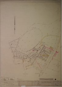
Plan - SANDHURST BOYS CENTRE COLLECTION: PART DETAIL SURVEY
Prepared by the Public Works Department for the Government of Victoria. Client is the Mental Health Department, Municipality is City of Bendigo. Site plan of area bounded by O'Dwyer St and Finn St, North Bendigo. Handwritten note on back - Update of whole centre 10/4/91. Details include: oval, tennis court, grandstand, area is bounded by an un-named watercourse. Also indicated are 14 nissen huts, 2 toilet blocks, 3 weatherboard buildings, 1 galvanised iron building,2 galvanised iron sheds (one new), residence, garage, fowl shed, and a carpark. bendigo, institutions, sandhurst boys centre, sandhurst boys centre site plan; -
 Bendigo Historical Society Inc.
Document - MARKS COLLECTION: PARISH PLAN OF WHITE HILLS
... Noone Department of Lands and Survey on the back--Plan of Land ...Sepia coloured map showing allotments in Parish of Sandhurst (White Hills) Written on LH side of map town and Suburban Lots White Hills Parish of Sandhurst. Scale is shown in chains. Surveyed by Horage Walker. Photo lithographed at the Department of Lands & Survey, Melbourne by J.Noone, Price 1/-. 6th. January 1865. Map shows Race Course Reserve at top of sheet, Municipal boundary is marked on LH side. Comments re vegetation throughout map. For example, poor soil timbered with Box scrub.on the back--Plan of Land White Hills Sandhurstbendigo, planning, white hills parish map, horage walker, j noone, department of lands and survey, -
 Bendigo Historical Society Inc.
Map - HUSTLER'S ROYAL RESERVE NO 2 MINE - PLAN OF THE HUSTLER'S ROYAL RESERVE NO 2 MINE
Plan of the Hustler's Royal Reserve No 2 Mine Bulletin No 33, Plate No V. Plan shows the Hustler's Royal Reserve No 2 (Main Shaft), Hustler's Royal Reserve No 2 (Park Shaft.), the Royal Hustler's, the Imperial Hustler's and the Extended Hustler's Freehold on the Hustler's Line of Reefs. Also mentioned is the Lightning Hill Line of Reefs. Map shows some of the levels, approximate boundary of lease and the boundary of Lease No 8892 and 8897. There are also street names and the locations of jail, lagoons, Post Office, Rosalind Park and the State School, High School and Continuation School. Geological Survey of Victoria emblem. H. Herman Director, W. Dickson, Secretary of Mines and The Hon. J. Drysdale Brown MLC, Minister of Mines. Signed by zh Whitdan, Underground Survey Office, Bendigo, September 1913.mining, parish map, hustler's royal reserve no 2 mine, royal hustler's, imperial hustler's, extended hustler's freehold, geological survey of victoria, h herman, w dickson, the hon j drysdale brown, h whitdan, hustler's line of reefs, lightning hill line of reefs -
 Bendigo Historical Society Inc.
Map - HUSTLER'S ROYAL RESERVE NO 2 MINE - PLAN OF THE HUSTLER'S ROYAL RESERVE NO 2 MINE
Plan of the Hustler's Royal Reserve No 2 Mine on the Hustler's Line of Reefs Bulletin No 33, Plate No VI. Boundary of Leases No 8898 and 8897 shown. Various levels shown and some geographical features. Geological Survey of Victoria emblem. H . Harman, Director, W. Dickson, Secretary for Mines and The Hon. J. Drysdale Brown, Minister of Mines and signed by H Whitdon, Underground Survey Office, Bendigo, September 1913. mining, parish map, hustler's royal reserve no 2 mine, hustler's line of reefs, geological survey of victoria, h herman, w dickson, the hon j drysdale brown mlc -
 Bendigo Historical Society Inc.
Map - UNITED HUSTLER'S & REDAN & K. K. MINES - PLAN OF THE UNITED HUSTLER'S & REDAN & K. K. MINES
... Geological Survey of Victoria H S Whitelaw Underground Survey Office ...Plan of the United Hustler's & Redan & K. K. Mines Bulletin No 33 Plate No XXXI. Shows depth of levels, Probable positions of reefs and natural surface with the poppet legs at the two shafts. Sill of shaft of the K. K. Mine 773.56 ft above Sea Level and sill of shaft of the United Hustler's & Redan Mine 745.62 above Sea Level. Also mentioned is the average amount of gold obtained per ton. Note on the top of page - Plates 4, 8, 13, 20, 26 & 31 form a Longitudinal Section from Fortuna Hustler's to Hustler's Consols Mine. Geological Survey of Victoria emblem and signed by H S Whitelaw, Underground Survey Office, Bendigo, September 1913. mining, parish map, united hustler's & redan & k. k. mines, geological survey of victoria, h s whitelaw, underground survey office bendigo -
 Bendigo Historical Society Inc.
Map - UNITED HUSTLER'S & REDAN & K. K. MINES - PLAN OF UNITED HUSTLER'S & REDAN & K. K. MINES
... Survey Office Plan of the United Hustler's & Redan & K. K. Mines ...Plan of the United Hustler's & Redan & K. K. Mines on the Hustler's Line of Reefs Bulletin No 33 Plate No XXVII. Plan shows depth of levels, Long Gully, Hustler's Line of Reefs, Lightning Hill Line of Reefs and approximate Boundary of Lease. Also mentions Comet Co. Geological Survey of Victoria emblem and signed by H S Whitelaw, Underground Survey Office Bendigo September 1913.mining, parish map, united hustler's & redan & k. k. mines, long gully, hustler's line of reefs, lightning hill line of reefs, comet co, h s whitelaw, geological survey of victoria, underground survey office -
 Bendigo Historical Society Inc.
Map - UNITED HUSTLER'S & REDAN & K. K. MINES - PLAN OF UNITED HUSTLER'S & REDAN & K. K. MINES
Plan of the United Hustler's & Redan & K. K. Mines on the Hustler's Line of Reefs Bulletin No 33 Plate No XXVIII. Plan shows depth of levels, stone encountered and some geological features. Geological Survey of Victoria emblem and signed by H S Whitelaw, Underground Survey Office Bendigo, September 1913. mining, parish map, united hustler's & redan & k. k. mines, united hustler's and redan shaft, k. k. shaft, h s whitelaw -
Clunes Museum
Plan - TITLE PLAN, DEPARTMENT OF LANDS AND SURVEY, PARISH OF CLUNES - COUNTY OF TALBOT, 1959
.1 1 PAGE PLAN LISTING TITLES FOR THE PARISH OF CLUNES 1959 (3 COPIES) SHEET 1 SCALE: 1 INCH TO 40 CHAINS .2 1 PAGE PLAN LISTING TITLES FOR THE PARISH OF CLUNES 1959 SHEET 2 SCALE: 1 INCH TO 2 CHAINSBY AUTHORITY A C BROOKS GOVT. PRINTER, MELBOURNE PARISH OF CLUNESparish of clunes, title plans clunes -
Clunes Museum
Map - MAPS, A.C. BROOKS GOVERNMENT PRINTER MELBOURNE
.1 PARISH OF CLUNES, COUNTY OF TALBOT. (3 COPIES) (1) STAMP: DRAWING OFFICE RECORDS COPY, STATE ELECTRICITY COMMISSION OF VICTORIA. ELECTRICITY DEPARTMENT (THIS PLAN MUST NOT BE TAKEN FOR FIELD USE. PLEASE DO NOT DEFACE) C71 ON LEFT BOTTOM CORNER, CLUNES SHEET 1 (2) '19' HANDWRITTEN ON ALL FOUR CORNERS AND PLASTIC TAB FOR HANGING (3) PLASTIC TAB FOR HANGING .2 MAP BECKWORTH COUNTY OF TALBOT (3 COPIES) (1) IN RED: B-61. L.4855. THE ALLOTMENTS COLOURED BROWN ARE FREEHOLD (2) WITH PLASTIC TAB FOR HANGING (3) WITH PLASTIC TAB FOR HANGING. '14' HAND WRITTEN IN ALL 4 CORNERS AND VARIOUS PENCIL NOTATIONS ON THE MAP..1.2 DRAWN AND REPRODUCED AT THE DEPARTMENT OF LANDS & SURVEY MELBOURNE. PRICE 2/- .1 IN PENCIL ON BOTTOM ' 211 ' 20%parish of clunes, electricity supply department, beckworth