Showing 112624 items matching "tracks/roads"
-
 Marysville & District Historical Society
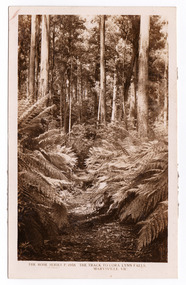
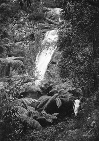
Postcard (item) - Black and white postcard, Rose Stereograph Company, The Track to Cora Lynn Falls, Marysville, Vic, 1913-1967
A postcard in a series produced by the Rose Stereograph Company in Victoria, Australia as a souvenir of Marysville.A black and white photograph of the track leading through the forest to the Cora Lynn Falls which is in the Cumberland Valley in Victoria. These falls are located on the Marysville-Wood's Point Road. Cambarville is notable for its giant mountain ash (Eucalyptus regnans) trees within the Cumberland Memorial Scenic Reserve, and relics from former sawmills and gold mining. The Big Culvert is located nearby on the Marysville-Woods Point Road, which was historically part of the Yarra Track. Cambarville was established as a timber mill town in the 1940s. Timber mill owners A Cameron and FJ Barton named Cambarville. They established the mill to salvage timber from trees destroyed in the 1939 bushfires. Cambarville was impacted by the 2009 Black Saturday bushfires and any remaining structures were destroyed. THE ROSE SERIES P. 4958/ COPYRIGHT/ THE TRACK TO CORA LYNN FALLS, MARYSVILLE, VIC. The reverse of postcard is illegible as it is covered by paper residue from when postcard was removed from an album. marysville, victoria, photograph, cora lynn falls, waterfalls, p. 4958, rose series postcard, rose stereograph company, souvenir, cambarville, marysville-wood's point road, eucalyptus regnans, cumberland memorial scenic reserve, mining, big culvert, yarra track, a cameron, fj barton, 1939 bushfires, 2009 black saturday bushfires, timber mills -
 Whitehorse Historical Society Inc.
Document, James Cowley Morgan Fisher, n.d
Document re James Cowley Morgan Fisher, Thomas Bowen and Charles Carter .Document re James Cowley Morgan Fisher, Thomas Bowen and Charles Carter and land at Dorset & Canterbury Road and LL Road (Boronia Road) and Canterbury Road.Document re James Cowley Morgan Fisher, Thomas Bowen and Charles Carter .fisher, james cowley morgan, bowen, thomas, carter, charles, l l vale road vermont, boronia road, vermont, vermont, dorset road, bayswater, canterbury road, vermont, bayswater -
 Ballarat Tramway Museum
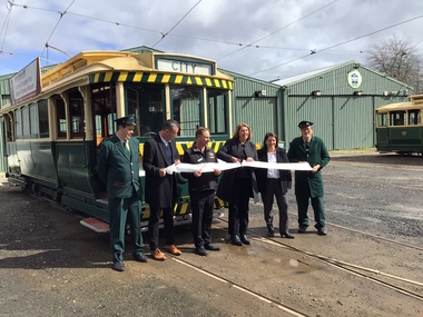
Photograph - Opening of the new track, Patricia Cameron, 10-9-2022
Digital image by Patricia Cameron at the time of the launch or opening of the relaid or replaced track in Wendouree Parade and depot extension. Has Sam Boon, Cr Daniel Maloney, BTM President Paul Mong, Catherine King MP, Juliana Addison MP and Len Millar - standing in front of tram 13. Catherine King - Minister for Infrastructure, Transport, Regional Development and Local GovernmentProvides information on the people involved at the time of the launch of the new replaced trackwork.Digital Image of the cutting of the ribbon to open the new track - 10 September 2022 btm, trackwork, opening, launch, tram 13, museum, depot -
 Puffing Billy Railway
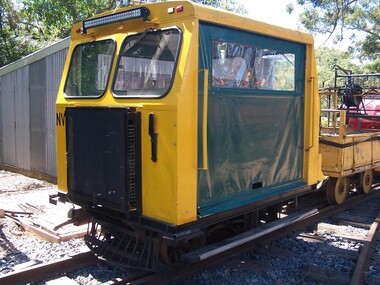
NVW 1, Motorised Trolly
NVW 1 - Track Patrol vehicle Rebuilt by Puffing Billy Volunteers given Number NVW 1 as it was built with a (VW) Volks wagon engine Was originally a trolley on the Australian Portland Cement Ltd at Fyansford Victoria Obtained by the Puffing Billy Preservation Society around 1968. Originally 3'6" ( 1067mm) before being rebuilt. Historic - Puffing Billy Track patrol - Rail Vehicle - NVW 1 NVW 1 - Track Patrol vehicle made of metal & steel with canvas vinyl blindsNVW 1puffing billy, nvw 1, trolley, trolly -
![Electric tramway construction in Riversdale Road [Surrey Hills]](/media/collectors/550653872162f11fb04854aa/items/661deb37344c8682d4fa54e0/item-media/661dec13344c8682d4fa98bd/item-fit-380x285.jpg) Kew Historical Society Inc
Kew Historical Society IncPhotograph - Electric tramway construction in Riversdale Road [Surrey Hills], E.J. Dower, 1916
Contextual or historic information One of a series of photographs, taken by Edgar James Dower in the second decade of the twentieth century. Born and raised in Olinda, his family later moved to Surrey Hills. He worked as an adult as a clerk in the city office of the Metropolitan Gas Company, and in his role as a 'collector', he was able to photograph scenes including the construction of tramlines and associated buildings in Kew, Hawthorn, Camberwell and Surrey Hills. Later he established a real estate agency with his brother - the E.J. Dower Real Estate Agency, Dandenong Office.The image is an historically significant record of the development of transport infrastructure which was used to connect Victorians in the first two decades of the twentieth century. This development resulted from increases in population and the consequent extension of Melbourne's suburbs. The photographs, both individually and collectively, richly detail the labour of workers and the tools and machinery used to create and extend Melbourne's tram network in the years preceding and during World War 1.Digital copy of an original mounted photograph of construction of the electric tramline in Riversdale Road, Surrey Hills.Annotated verso: "Showing the commencement of preparing for electric trams in Riversdale Road / Taken from the corner of Union Road, note Essex road on right with picket fencing"theme --- travelling by tram, theme -- connecting victorians by transport and communications, trams -- boroondara (vic.), tramlines -- surrey hills -
 Ringwood and District Historical Society
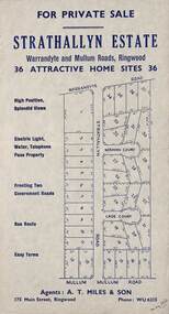
Flyer, Land Sale Advertisement - Strathallyn Estate, Ringwood, Victoria - circa 1950
Advertisement for private sale of 36 home sites in the Warrandyte Road and Mullum Mullum Road area of Ringwood, with map showing layout of subdivision and summary of local features and services. Handwritten notation indicates May, 1950.Subdivision includes Warrandyte Road, Strathallyn Road, Norman Court, Lade Court, and Mullum Mullum Road. Agents: A.T. Miles & Son, 175 Main Street, Ringwood, Phone WU6215. -
 Kew Historical Society Inc
Photograph - Street Works, Studley Park Road, March 1934
Studley Park Road, like most streets in Kew, was originally a dirt road. Street works during the Great Depression included bituminising major roads in the district. This photograph of Council works originated in the City of Kew Engineers Department as a record of works undertaken. It was given to the collection by a Mrs Fisher in 1998.Well provenanced photograph of Council-funded public works in Kew during the Great Depression. Original sepia monochrome positive of Council workers standing on and beside a dray in Studley Park Road, Kew while resurfacing of the street was taking place. The Kew Junction is just visible behind the men.Typed reverse: "B4 / Kew C.C. / Spreading premixed material on Studley Park Road with drag spreader, view from rear of machine, March 1934"roadworks -- kew (vic.), street works -- kew (vic.), public works kew (vic.), studley park road -- kew (vic.), city of kew -- engineers department, city of kew -- public works -- great depression -- 1930s -
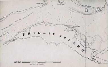 Phillip Island and District Historical Society Inc.
Photograph, Bryant West
One of a collection of over 400 photographs in an album commenced in 1960 and presented to the Phillip Island & Westernport Historical Society by the Shire of Phillip IslandPhotograph of a Map of Phillip Island. The first to show Fort Dumaresq, track to beach and beginning of road to South coast. local history, photography, photographs, exploration, maritime, documents, maps, phillip island, john jenner, bryant west -
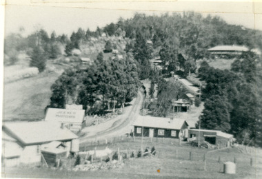
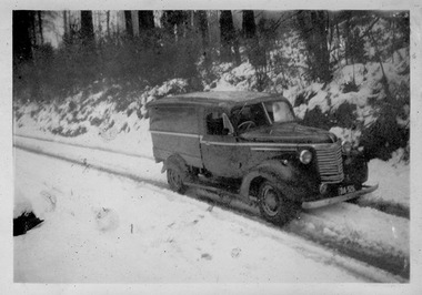 Marysville & District Historical Society
Photograph (Item) - Black and white photograph, c1950
A digital copy of a black and white photograph of one of Barton's Delivery fleet of vehicles from Marysville in Victoria, driving down a snow covered track.A digital copy of a black and white photograph of one of Barton's Delivery fleet of vehicles from Marysville in Victoria, driving down a snow covered track. Thomas John Barton was born in 1836 in Gloucestershire and after his father died in 1850 arrived in Melbourne in 1852 along with his mother, adult sisters, younger brothers, his uncle, his uncle's wife Suzanna and their family. Thomas tried gold mining at Woods Point but found it too difficult. He then partnered with Ewen Hugh Cameron to provide the miners with meat. In 1864 they purchased a plot of land in Marysville and set up a butchers/abattoirs and from there began their business of taking supplies to the miners at the nearby Woods Point and Jamieson goldfields. In 1865 the business was firmly established and Thomas married Selina Croker at Heidelberg and brought her back to Marysville. Their first home was 'The Chestnuts', which included the store, and was situated on the town side next to the Steavenson River. Sadly, in 1876 Selina died of complications after giving birth to their sixth child. Thomas was in need of a nanny to care for his six children, including the newborn baby, and so he employed Emily Ada Sparke, who is the eldest daughter of the local school teacher. Thomas and Emily subsequently marry in 1878 and they go on to have a further 10 children over the next several years. Thomas assisted in the establishment of the first school in Marysville in 1870 and remained a very active member of the community including as a Councillor for the Shire of Healesville, Shire President and he was also appointed as a Justice of the Peace. Thomas died in Carlton in 1911. After their father's death, his sons Fred and Frank took over the family business, which was then known as Barton Bros Store which continued to operate until sometime in the 1970's.marysville, victoria, barton's store, thomas john barton, ewen hugh cameron, woods point, jamieson, gold mining, goldfields, selina croker, the chestnuts, emily ada sparke, shire of healesville, fred barton, frank barton, barton bros store, francis adam barton, frederick john barton, photograph, barton's garage, barton bros stables, chevrolet van -
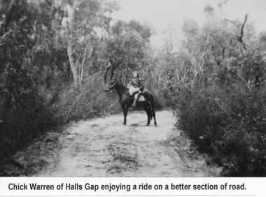 Halls Gap & Grampians Historical Society
Photograph - B/W
Young woman is Chick Anderson (nee Warren) riding on the Dunkeld Road. It is said that this was a better section of the road. Chick has told us she was 7yrs old when this photo was taken, c1934-5a young woman seated on a horse on a sandy track surrounded by thick bush.Chick Anderson on Dunkeld Rd 1934-35 written on backaccess routes, grampians/dunkeld rd, people, warren -
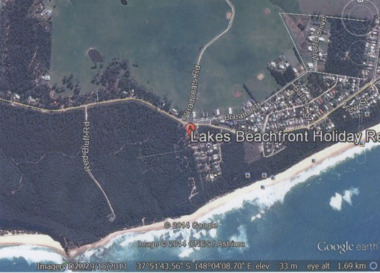 Lakes Entrance Historical Society
Photograph - Lake Tyers Beach, Google Earth, 2014
Colour photograph of Lakes Beachfront Holiday Resort showing Lake Tyers Beach Road, Barracouta Road and Salmon Road, walking track with ocean beach on Bass Strait in background, Bream Road in foreground, Lake Tyers Beach VictoriaLakes Beachfront Holiday Reocean, caravan parks -
 Mt Dandenong & District Historical Society Inc.
Photograph, Kalorama Gap in 1927, 1927
View of the Kalorama Gap (FiveWays) in 1927. Buildings shown are Jeeves' Garage, FiveWays Cafe, Nicholl's Store, Mountjoy. CRB Main Road, Ridge Road, Old Coach Road and barber's Road also visible. This photograph has a detailed inscription on the back handwritten by John Lundy-Clarke in 1974. The Kalorama Gap in 1927. Showing Jeeves Garage Fiveways Cafe Nicholls Store 'Mountjoy' C.R.B Main Rd Center Ridge Road Right of Center Old Coach Road lower right corner behind shed Barber's Road going left through clump of trees in center kalorama gap, kalorama, fiveways, fiveways cafe, jeeves, jeeves garage, garage, nicholls store, mountjoy, barbers road, old coach road, ridge road, main road, crb road -
 Glen Eira Historical Society
Album - Album page, Glen Eira Road, Circa 1972
This photograph is part of the Caulfield Historical Album 1972. This album was created in approximately 1972 as part of a project by the Caulfield Historical Society to assist in identifying buildings worthy of preservation. The album is related to a Survey the Caulfield Historical Society developed in collaboration with the National Trust of Australia (Victoria) and Caulfield City Council to identify historic buildings within the City of Caulfield that warranted the protection of a National Trust Classification. Principal photographer thought to be Trevor Hart, member of Caulfield Historical Society. Most photographs were taken between 1966-1972 with a small number of photographs being older and from unknown sources. All photographs are black and white except where stated, with 386 photographs over 198 pages. From Glen Eira Heritage Management Plan 1996 by Andrew Ward: Since 1990, valuable historic houses to have been demolished include "Noris", later "Quethiock", and "Koala" (1875) at 34 Balaclava Road, "Urandaline", later Samford private hospital at 510 Glen Eira Road, and No. 9 Lempriere Avenue. When the Caulfield Tramway Company opened its single line horse tramway along Glen Eira Road to Caulfield station in 1889, the eastern end of this road passed through open paddocks and alongside "Urandaline", a charming late Victorian villa residence with comer pinnacle roof, demolished in 1995.Page 59 of Photograph Album with five photographs, one portrait of the exterior of a house on Glen Eira Road, the other four are photos of sections of advertising materials for Urandaline Estate.Hand written: 508 Glen Eira Road [under top left photo] / 58 [bottom left] trevor hart, glen eira road, caulfield north, urandaline, urandaline estate, horse tram, land subdivision, real estate advertising, verandahs -
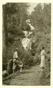
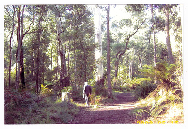 Marysville & District Historical Society
Photograph (item) - Colour photograph, 15-05-2008
A colour photograph of a man walking along the walking track that leads to Keppel Falls near Marysville in Victoria.A colour photograph of a man walking along the walking track that leads to Keppel Falls near Marysville in Victoria. Keppel Falls are named after the Keppel Family who were one of Marysville's earliest pioneering families. 2008 05 15walking track, marysville, victoria, photograph, keppel family, keppel falls, waterfalls -
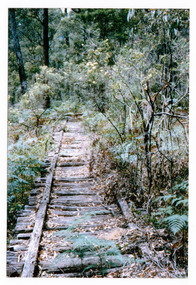 Marysville & District Historical Society
Photograph (item) - Colour photograph, 01-1964
A colour photograph of the timber tramway bridge along the Michaeldene Walking Track near Marysville in Victoria.A colour photograph of the timber tramway bridge along the Michaeldene Walking Track near Marysville in Victoria. The Michaeldene Trail to Taggerty River Lookout is a 4.3 kilometer lightly trafficked loop trail located near Marysville, Victoria. The track is one of several walking tracks located in and around Marysville in Victoria.MARYSVILLE JANUARY 1964timber tramway, michaeldene walking track, marysville, victoria, walking track -
Whitehorse Historical Society Inc.
Map, Nunawading Shire, 1892
Photocopy of an enlargement of map of Shire of Nunawading showing landowners in 1892.Photocopy of an enlargement of map of Shire of Nunawading showing landowners in 1892. Covers Middleborough Road to Ringwood boundary. One map (Blackburn) from north of Whitehorse Road to Highbury Road, 2nd map (Mitcham) Bulleen to south of Canterbury Road; 3rd map Whitehorse Road to Highbury Road.Photocopy of an enlargement of map of Shire of Nunawading showing landowners in 1892. maps, shire of nunawading, blackburn, blackburn south, nunawading, forest hill, vermont, mitcham, vermont south -
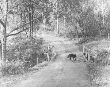 Ringwood and District Historical Society
Photograph, Deep Creek Road early 1900s
Black and white photograph of bend in unmade road. Bridge with black dog standing on bridge. Forest area on either side of road. (2 copies)Typed below photograph, "Deep Creek Road in early days". -
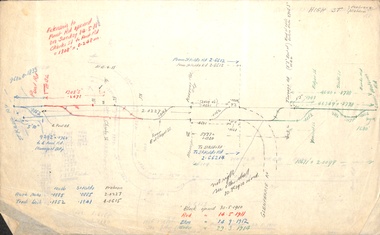 Melbourne Tram Museum
Document - Research Notes, H. S. McComb, Extracts of PMTT Minutes - track layouts, 1950's
Set of papers, handwritten concerning the development and timing of the "PMTT", Prahran and Malvern - 6 sheets. Prepared by H. S. McComb - gives layout of the PMTT system, primarily of Burke Road, sketches of track layout, opening dates, sketches of various junctions, bridges, track miles, junctions, reconciliation of track lengths from various sources of High St Malvern, extension to Punt Road and St Kilda Roads includes duplications and a Wattle Tree Road. Items 2041 to 2052 within box 72.3 in a brown folder marked "PMTT" in red pencil.trams, tramways, pmtt, malvern, routes, track, surveys, punt rd, high st, wattle tree rd, duplications -
 Marysville & District Historical Society
Photograph (item) - Black and white photograph, Unknown
An early black and white photograph which shows a man and a women standing on the track that leads to the base of Steavenson Falls in Marysville in Victoria.An early black and white photograph which shows a man and a women standing on the track that leads to the base of Steavenson Falls in Marysville in Victoria. The Steavenson Falls are named after the Victorian Assistant Commissioner of Roads and Bridges, John Steavenson who arrived in Victoria in the early 1860s.steavenson falls, marysville, victoria, waterfalls, john steavenson -
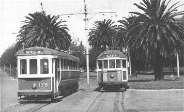 Melbourne Tram Museum
Photograph - T class tram 177 and W2 606 - Dandenong Road, c1960
The photograph shows T class tram 178 (Special) east bound in Dandenong Road, Windsor passing W2 class tram 606 (City Route 64) at the western end of the Reserved track. T178 was scrapped in 1961. Tram 606 has adverts for Strammit ceilings and Remy Martin Brandy.Yields information about the operation of a T class tram and W2 class trams c1960.Black and White Photograph with notes on rear.In ink on rear "T class 178 passing W2 class 606 at entrance to Dandenong Road Reservation, Windsor"tramways, trams, dandenong road, t class, tram 178, w2 class, tram 606 -
 Marysville & District Historical Society
Photograph (item) - Black and white photograph, Unknown
A black and white photograph which shows a woman walking along the track that leads to the base of Steavenson Falls.A black and white photograph which shows a woman walking along the track that leads to the base of Steavenson Falls. The Steavenson Falls is named after the Victorian Assistant Commissioner of Roads and Bridges, John Steavenson who arrived in Victoria in the early 1860s.steavenson falls, marysville, victoria, waterfalls -
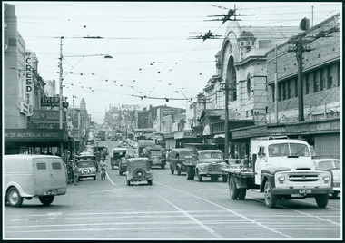 Camberwell Historical Society
Photograph, Camberwell, Victoria, view of Burke Road and stores, c. 1950
Print of photograph looking north up Burke Road, with Rivoli Cinema on the right. Inscription 'Camberwell, Victoria, view of Burke Road and stores c. 1950' Camberwell, Victoria, view of Burke Road and stores c. 1950camberwell -
Glenelg Shire Council Cultural Collection
Photograph - Photograph - Main Breakwater Construction, Jan-60
Port of Portland Authority ArchivesFront: 'Wharf Area: View N.5. showing transit shed under erection and rail tracks being laid. Note spray wall in background. Jan '60 - Typed on bottom of photoport of portland archives, portland harbour, transit shed -
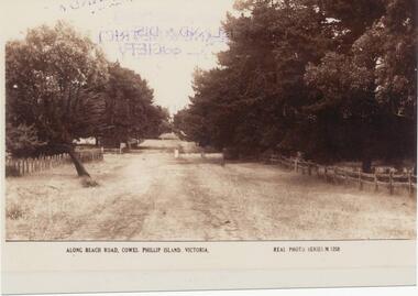 Phillip Island and District Historical Society Inc.
Photograph, Early 20th Century
One of 20 photographs/postcards donated by Mary KarneySepia photograph copy of a postcard. Beach Road, Cowes with fences and trees lining the road."Along Beach Road, Cowes, Phillip Island, Victoria." "Real Photo Series M 1258"beach road, cowes phillip island, cowes phillip island, mary karney -
 Ringwood and District Historical Society
Photograph, Deep Creek Road bridge early 1900s
Black and white photograph taken from unmade road. Road zigzags over bridge with wooden balustrades. Bushland setting. (3 copies)Typed below photograph, "Deep Creek Road bridge in the early days". -
 Melton City Libraries
Photograph, Wendy, Bon and Peter Barrie, c.1948
Sections of the property from the Ferris Rd to the Toolern Creek were compulsorily acquired for the construction of the Melton By Pass road to become the Western Freeway. The freeway plan divided the original 1911“Darlingsford” farm. The section of the Ferris Rd 70-acre paddock belonging to Bon became the Freeway and roundabout. The construction to the west passed over the paddocks and the internal track along the fences connecting the Barrie brothers to the original Homestead at the Toolern Creek. Wendy, Bon and Peter Barrie entering Ferris Road from houselocal identities -
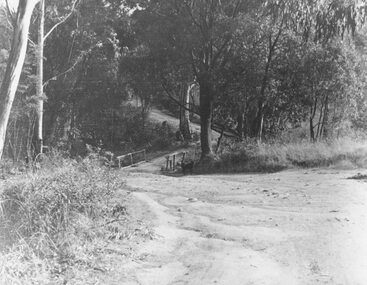
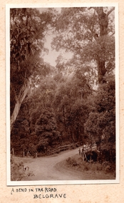 Southern Sherbrooke Historical Society Inc.
Photograph, A Bend In The Road, Belgrave, c. 1920s
Photo shows a bend in the road, Belgrave, most likely on Monbulk Road below Sherbrooke Forest. An unmade road crosses a small gully. A group of three or so young people are leaning over the bridge railing. The area is heavily treed. A BEND IN THE ROAD hand-wriiten in ink below the photo on the album page -
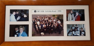 Vision Australia
Photograph (item) - Image, Staff at RVIB St Kilda Road - 1998
Five photographs of groups of staff members at RVIB. Image 1 - Maree Littlepage, Christine Harding, ?? Image 2 - ? and Sandie Mackevicius Image 3 - Group photograph in driveway: Blue letters: A - Chris Headland, B - Barbara Williams, C - Ramona Mandy, D - Barbara Royce, E – Tess Rousso, F – Robyn Gale, G – Peter Cronin, H – Chris Edwards, I – Glen Morrow, J – Graeme Craig, K – Barbara McKenzie, L – Marg Harvey, M – Judy Williams, N – Len Stephens, O – Nina Sutton, P – Sherry Cunningham, Q – Marissa Depitta, R – Uli Pfisterer, S – Rosemary, T – Maree Sheehan, U – Linda Rivette, V – Rachel Grealy, W – Fiona Pelusi, X – Maree Littlepage, Y – Danielle, Z – Sophie Tzoukalis. (Between Pelusi and Stephens, Christine Harding. Green letters: A – Emma Rogers-Wilson, B – Rory Fraser, C – Gary Stinchcombe, D – Alex Zolradkovic, E – Nicola Misso, F – Mary Barron, G – Barbara, H – Kathy Lazzaro, I – Linda Morris, J – Pam McAleese. Image 4 - ?? Image 5 - Robyn Gale, ??RVIB - St Kilda Road - 1998royal victorian institute for the blind, staff -
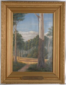 Glenelg Shire Council Cultural Collection
Painting, A Bush Track, n.d
CEMA Art Collection Previously located in History HouseThe painting illustrates a bush scene with a large gum tree in the foreground. To the left of the tree is a sunny track with long shadows formed by surrounding trees. On the track heading towards the viewer is a covered wagon drawn by a white horse. Behind the wagon is dense bush with tall trees and thick shrubs. Extending from the trees is a band of white clouds followed by light blue sky. The work is framed in a heavy, moulded, ornate, gilded frame with exposed canvas.Front: A.S.Murray (painted signature lower right) A Bush Track (plaque - lower centre on frame) Back: W.Hamer sticker Electoral Post Office sticker Hamilton Victoria stickerbush, landscape, australian -
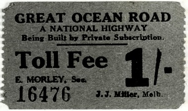 Lorne Historical Society
Photograph - Great Ocean Road Toll pass
Tolls were used on the Great Ocean Road from 192 until 19. . Toll gates were at Eastern View and Lorne. Money collected was used to help pay for the construction and maintenance of the road.The Great Ocean Road was built largely by returned serviceman from the First World . The road was built to link the coastal towns, provide better access, to foster tourism and employ the returned servicemen. Fewer private vehicles travelled the road then, most tourists came on coaches and buses. Tourists stayed in guesthouses and hotels. A laminated rectangular , beige , cardboard Great Ocean Road Passenger Service Annual Pass for 1936. Printing is in red lettering with black ink handwritingGreat Ocean Road Passenger Service/Annual Pass/For the year ending November 30th 1936 No 2/Issued to K Quicks Sedan Motors/Subject to compliance with Government Trust Regulations/For Passenger Vehicle Registered No 220529/For the Great Ocean Road Trust PTY LTD/ Date of Issued 3/12/35/ signature unclear/ Secretary/ This pass, which is for Driver and Vehicle only, must be carried by/ Driver, and produced to Toll Gate- keeper on demand, otherwise ordinary / Toll Fees are chargeable.great ocean road, great ocean road tolls