Showing 688 items matching "water into gold"
-
 Lions Club of Maldon Inc.
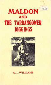
Book, A Concise History of Maldon and the Tarrangower Diggings, 1979
... Contents include early settlement, gold discovery in 1853, early water problems, public institutions. ...Contents include early settlement, gold discovery in 1853, early water problems, public institutions. ...Concise historical record of events rather than people. Contents include early settlement, gold discovery in 1853, early water problems, public institutions. Mention of Chinese on Tarrangower, and German and Italian settlers. Book of 86 Pagesmaldon, tarrangower, gold, victoria -
 Rutherglen Historical Society
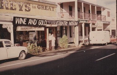
Image, January 1986
... Gold Country Museum. The building is located in Main Street Rutherglen next to the Poachers' Paradise Hotel. Below the banner is a shop sign "Hairdresser & Tobacconist" and another "Tourist Information". A man and woman are standing in front of the shop watering...Gold Country Museum. The building is located in Main Street Rutherglen next to the Poachers' Paradise Hotel. Below the banner is a shop sign "Hairdresser & Tobacconist" and another "Tourist Information". A man and woman are standing in front of the shop watering ...This shop, in Main Street Rutherglen, near Poachers Paradise pub (originally the Rutherglen Hotel), was owned and operated as a barber shop by Jack O'Keefe. This photograph was taken in 1986. The couple in front of the building are probably Jack O'Keeffe and his wife. At present (2019) part of this shop is again operating as a hairdressers, as Jack and the Fox.Colour photograph of the front of a shop with a banner below the veranda identifying it as the Wine and Gold Country Museum. The building is located in Main Street Rutherglen next to the Poachers' Paradise Hotel. Below the banner is a shop sign "Hairdresser & Tobacconist" and another "Tourist Information". A man and woman are standing in front of the shop watering the plants. Above the veranda is another sign indicating that some part of the shop was once used as a billiard parlor.Writen on the back of the photo: "January 1986"jack okeefe, barbers, hairdressers -
 Unions Ballarat
The astonishing history of Ballarat 1851-1855, Bradby, Doug, 2018
... gold. Chapter 6. The Monster Nuggets. Why Sarah Sands from Ballarat was introduced to Queen Victoria at Windsor Castle. Chapter 7. Settling Down on Ballarat. How and why some diggers settled permanently at Ballarat as miners. Mining in the year of Eureka. How the miners tackled the problems of shepherding and the mining consequences of the Eureka Stockade. Chapter 8. The Gravel Pits. How the miners of Ballarat Flat learnt to work ‘in the water...gold. Chapter 6. The Monster Nuggets. Why Sarah Sands from Ballarat was introduced to Queen Victoria at Windsor Castle. Chapter 7. Settling Down on Ballarat. How and why some diggers settled permanently at Ballarat as miners. Mining in the year of Eureka. How the miners tackled the problems of shepherding and the mining consequences of the Eureka Stockade. Chapter 8. The Gravel Pits. How the miners of Ballarat Flat learnt to work ‘in the water ...Chapters Chapter 1. 1848-50. The Discovery of Gold in the Port Phillip District. How a shepherd found Victoria’s first gold but failed to produce a goldrush. Chapter 2. The Discovery of Gold in Victoria. How a publican, a squatter, some more shepherds, a doctor, and an ex mailman, found the gold that produced the Victorian goldrush. Chapter 3. The Discovery of Gold at Ballarat. How the Ballarat gold field was discovered by Thomas Hiscock at Buninyong, and by old John Dunlop and young James Regan at Poverty Point, and by Old Tom Brown of Connor’s Party at Golden Point. Chapter 4. The Genesis of Ballarat. How the diggers arrived, mined, lived, and governed themselves at Ballarat. Chapter 5. The Exodus from Ballarat. Why the diggers left Ballarat when they had found less than 1% of Ballarat’s gold. Chapter 6. The Monster Nuggets. Why Sarah Sands from Ballarat was introduced to Queen Victoria at Windsor Castle. Chapter 7. Settling Down on Ballarat. How and why some diggers settled permanently at Ballarat as miners. Mining in the year of Eureka. How the miners tackled the problems of shepherding and the mining consequences of the Eureka Stockade. Chapter 8. The Gravel Pits. How the miners of Ballarat Flat learnt to work ‘in the water.’ Chapter 9. Towards the Tableland. What the miners did when they hit a ‘wall of rock.’Relevance to the history of Ballarat, gold mining, Sovereign Hill and the Eureka Stockade.Paperback book; 176 pages. Front cover: red background; illustration of miners in white; author's and illustrator's names and title. btlc, ballarat trades and labour council, ballarat trades hall, history - ballarat, history - gold mining, eureka stockade -
 Ballarat Heritage Services
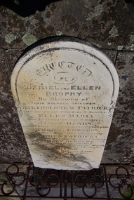
Photograph - Photograph - Colour, Clare Gervasoni, Brophy Gravestone at the Ballaarat Old Cemetery, 2013, 2013
... gold. With four Irish friends he set off for Bendigo on foot. Water was scarce on the track and they worked at a quarry near Keilor until the winter rains began. ...gold. With four Irish friends he set off for Bendigo on foot. Water was scarce on the track and they worked at a quarry near Keilor until the winter rains began. ...Daniel Brophy was born on 13 November 1832 at Castlecomer, County Kilkenny, Ireland. He was the youngest son of William Brophy, farmer, and his wife Margaret Purcell. In the Irish rebellion of 1798 the family estates had been confiscated. William Brophy escaped to Newfoundland returning after fourteen years and regained some of his property. Daniel Brophy was educated in local schools including a Quakers school. At 15 Daniel Brophy went with his family to Quebec in a migrant ship whose passengers were decimated by fever. His mother died on the voyage and his father soon after landing. Daniel found work in a shipyard but did not like it and entered a grocery warehouse. Brophy arrived at Melbourne in 1853 in search of gold. With four Irish friends he set off for Bendigo on foot. Water was scarce on the track and they worked at a quarry near Keilor until the winter rains began. The party was credited with the first discovery of payable gold at Taradale, but by 1855 they had moved to Ballarat. There Daniel Brophy proved himself a shrewd investor in many successful mining ventures. He started as the first sluice man in the Great Extended Mine and later became a director and chairman when it was renamed the Band of Hope and Albion; its total yield was about £3,000,000. Brophy also invested in a Ballarat hotel which he greatly enlarged and in landed property. An enthusiastic promoter of local industries, he became a director of the Phoenix Foundry Co. and of the Ballarat Woollen Mills. Brophy was an Irish Nationalist who first dug for gold at Bendigo and Taradale. He was a Knight of the Order of St George, mining manager, mining Investor and hotelkeeper. In 1859 he had married Ellen Mary Berkery; he was survived by five of their ten children.Colour photographs of the Brophy headstone in the Ballaarat Old Cemetery . ballaarat old cemetery, eureka stockade, daniel brophy, ellen brophy, bartholomew brophy, ellen maria brophy, james henry brophy, thomas edward brophy, mary berkery, daniel patrick brophy, william brophy, ellen berkery -
 Ballarat Heritage Services
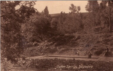
Photograph - Photograph - Black and White, Sutton Spring, Daylesford
... water pumps. The spring is named after the Sutton brothers of Cornwell, who discovered it while looking for alluvial gold along Wombat Creek in the 1850s. ...water pumps. The spring is named after the Sutton brothers of Cornwell, who discovered it while looking for alluvial gold along Wombat Creek in the 1850s. ...Emerging from the base of Wombat Creek Sutton Spring has two mineral water pumps. The spring is named after the Sutton brothers of Cornwell, who discovered it while looking for alluvial gold along Wombat Creek in the 1850s. By 1900, a trench had been dug to expose the spring, and a pipe had been driven through the spring eye. Sandstone rockwork encircled the trench. On 27 February 1907 the Sutton Mineral Spring Reserve was gazetted. By that time the trench had been enlarged and rendered, and a lean-to shelter had been built over the approach track. In 1927 Wombat Creek was rerouted allowing the land around the spring to be cleared and pipework repaired. Five bores were dug in 1929 and equipped with hand pumps. The bores were all shallower than 9.7 m. An attempt was made to replace one of these bores with a new bore, however it was not possible due to ground instability. These two bores are the oldest of all the mineral springs open to the public. Also in 1929 Council contemplated encouraging private enterprise to establish a ‘hydrobath’ similar to those in Europe, after mineral water had been discovered flowing from several other vents in sandstone and slate strata below the typical level of the creek. However, the option was not enacted although at the time to capture the flow another bore to a depth of 15m was sunk. In 1936 architect P. Scott Williams adopted a similar notion and examined the prospect of establishing a Hydropathic establishment above Sutton Springs, assuming a reliable mineral water supply could be found. That idea also lapsed. In October 1997 the Sutton Spring trench was restored to enable the public to again take mineral water at the spring. The restoration included clearing the sides of the creek and removing willow root growth. In 2002 a major overhaul of the trench and its underground works was undertaken and all plumbing replaced. This involved re-routing the creek through sandbagging, covering the spring eye with geofabric and then concrete. Unfortunately due to ongoing water quality issues, public access to take water from the trench was closed, however the trench can still be viewed.A mineral water spring at Daylesford is surrounded by a drystone wall. mineral water, sutton spring, daylesford, central springs, p. scott williams -
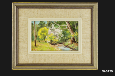 Whitehorse Historical Society Inc.
Painting - Yarran Dheren, Yarran Dheren '88, 1988
... Oil Painting of bush setting with water course and yellow wattle in flower and pink blossom tree in centre. Mounted in beige cotton fabric with inner beige plastic frame. Outer frame of brown wood with gold...Painting Yarran Dheren Reserve Signed by Barbara Rogalski Oil Painting of bush setting with water course and yellow wattle in flower and pink blossom tree in centre. Mounted in beige cotton fabric with inner beige plastic frame. Outer frame of brown wood with gold ...Painting of Yarran Dheren by Barbara Rogalski, a member of Whitehorse Historical Society. Painting is one of a set of 4.Oil Painting of bush setting with water course and yellow wattle in flower and pink blossom tree in centre. Mounted in beige cotton fabric with inner beige plastic frame. Outer frame of brown wood with gold trim. Painted at Yarran Dheren, Mitcham.Signed by Barbara Rogalskipainting, yarran dheren reserve -
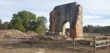 Ballarat Heritage Services
Photograph, Grand Duke Mine, Timor, Victoria, 04/05/2025
... water from this mine. When mining started at Timor in the late 1860s the ground here was very wet. If miners were to have any success in reaching the gold they had to remove the water from the ground. ...water from this mine. When mining started at Timor in the late 1860s the ground here was very wet. If miners were to have any success in reaching the gold they had to remove the water from the ground. ...Running through this reserve was one of Victoria's richest gold deep leads. From 1869 to 1896 this mine produced 216,000 ounces of gold, valued at over £885,000. The Timor area was mainly mined by the Duke and Timor Gold Mining Company, later known as Duchess of Timor, Duke, and Grand Duke. On 03 May 1869, at a traditional afternoon ceremony, the machinery was started and launched by the old process of 'giving it a name'. A baptismal ceremony was performed, with a Miss Eliza Watson dashing a bottle of champagne over the fly wheel on its first revolution and proclaiming its name to be 'The Galatea'. The mine here was renowned for the massive pumping engine it boasted. Imported from England, the massive Cornish pump was an improvement that was added in 1874. It had a 30 ton iron beam. The mine was the economic centre of this area, employing hundreds of men over its 27 years. At the height of its operation the company's proprietors boasted that nearly all the inhabitants of the nearby towns of Timor and Bowenvale depended on the mine for support. There were some tumultuous times at the mine, with periods of financial strife as well as accidents. When the pumps broke down in 1879 the mine flooded and remained out of action for two years. Mining was a dangerous occupation and a tragic accident in December 1883 claimed the lives of four men. As the ground here was so wet, pumping water out of the mine was crucial to safely reach the gold. It was this pumping engine, reported to be the largest of its kind in Australia, and comparable in size to just two others in the world, that was the key to the success of the Grand Duke mine. Many other smaller nearby mines also had their water pumped out. During the last seven years of the mine's operation it pumped out 2,000 gallons of water every minute, making this the longest and most continuous wet mine in the state. As well as the pump house and engine, there were four main shafts, 12 Cornish flue boilers, eight iron puddling machines and one battery of 20 heads. A massive pumping engine The arch before you is all that remains of the pump house that served to remove water from this mine. When mining started at Timor in the late 1860s the ground here was very wet. If miners were to have any success in reaching the gold they had to remove the water from the ground. To deal with this challenge the company imported a massive Cornish pumping engine from England to pump water out of the mine. It was reputed to be one of the best pumping engines in the world at the time. The engine generated 270 horsepower and its iron beam, weighing 30 tons, was the largest in Victoria. The beam of the large pumping engine see-sawed on this pump house wall to move the plunger or bucket in the pump up and down. The vertical cylinder was 80 inches in diameter with a stroke of 10 feet. The piston itself was eight inches in diameter and 17 feet high and the piston pump had a diameter of 22 inches. For such large engines a massive wall to support the beam was necessary. The piston operated on the downstroke and consequently the cylinder had to be anchored to a considerable foundation to overcome the weight of the pump rods in the shaft. The whole apparatus had to be contained in a tall building because of its vertical configuration. The pumping engine's building has beam walls six feet wide and over 26 feet long which rest on foundations 16 feet deep. The granite used to construct the arch was quarried at Mt Hooghly, some eight or nine kilometres away.Colour photographs of the Grand Duke Mine at Timor near Maryborough, Victoria.grand duke mine, timor, maryborough, mining, duke and timor gold mining company, duchess of timor -
Ballarat Heritage Services
Photograph - Photograph - Colour, Hepburn Springs Reserv, 2025, 12/12/2020
... gold mining activities. The extent of the reserve was increased to its present size in the early 20th century as a result of local pressure for protection of the mineral springs local pressure and on the recommendation of Dunn that a network of Mineral Springs Reserves of standard size be established throughout Victoria. hepburn springs locarno mineral water Hepburn Springs Reserve Locarno Spring Edna Walling Hepburn Springs Pavilion Colour photograph of Hepburn Springs Reserve and the encroaching weeds (broom, vinca, blackberry. . ...The Hepburn Mineral Springs Reserve is approximately 30 hectares of public land adjacent to Hepburn Springs township that includes the Hepburn Mineral Springs bathhouse. The reserve, which contains a series of mineral springs that have been in continuous public use for drinking and bathing since the mid-19th century, are the best known of the large concentration of more than 100 mineral springs in Victoria's Central Highlands first systematically inventoried by the Geological Survey of Victoria in 1910 under Director of E.J. Dunn (1904 - 1912). A reserve of 0.5 hectares was first created on the site in 1868 to protect the springs from surrounding gold mining activities. The extent of the reserve was increased to its present size in the early 20th century as a result of local pressure for protection of the mineral springs local pressure and on the recommendation of Dunn that a network of Mineral Springs Reserves of standard size be established throughout Victoria.Colour photograph of Hepburn Springs Reserve and the encroaching weeds (broom, vinca, blackberry. .hepburn springs, locarno, mineral water, hepburn springs reserve, locarno spring, edna walling, hepburn springs pavilion -
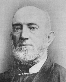 Ballarat Heritage Services
Photograph - Photograph - Colour, Clare Gervasoni, Daniel Brophy
... gold. With four Irish friends he set off for Bendigo on foot. Water was scarce on the track and they worked at a quarry near Keilor until the winter rains began. ...gold. With four Irish friends he set off for Bendigo on foot. Water was scarce on the track and they worked at a quarry near Keilor until the winter rains began. ...Daniel Brophy was born on 13 November 1832 at Castlecomer, County Kilkenny, Ireland. He was the youngest son of William Brophy, farmer, and his wife Margaret Purcell. In the Irish rebellion of 1798 the family estates had been confiscated. William Brophy escaped to Newfoundland returning after fourteen years and regained some of his property. Daniel Brophy was educated in local schools including a Quakers school. At 15 Daniel Brophy went with his family to Quebec in a migrant ship whose passengers were decimated by fever. His mother died on the voyage and his father soon after landing. Daniel found work in a shipyard but did not like it and entered a grocery warehouse. Brophy arrived at Melbourne in 1853 in search of gold. With four Irish friends he set off for Bendigo on foot. Water was scarce on the track and they worked at a quarry near Keilor until the winter rains began. The party was credited with the first discovery of payable gold at Taradale, but by 1855 they had moved to Ballarat. There Daniel Brophy proved himself a shrewd investor in many successful mining ventures. He started as the first sluice man in the Great Extended Mine and later became a director and chairman when it was renamed the Band of Hope and Albion; its total yield was about £3,000,000. Brophy also invested in a Ballarat hotel which he greatly enlarged and in landed property. An enthusiastic promoter of local industries, he became a director of the Phoenix Foundry Co. and of the Ballarat Woollen Mills. Brophy was an Irish Nationalist who first dug for gold at Bendigo and Taradale. He was a Knight of the Order of St George, mining manager, mining Investor and hotelkeeper. In 1859 he had married Ellen Mary Berkery; he was survived by five of their ten children.Black and white image of Daniel Brophy . ballaarat old cemetery, eureka stockade, daniel brophy, ellen brophy, bartholomew brophy, ellen maria brophy, james henry brophy, thomas edward brophy, mary berkery, daniel patrick brophy, william brophy, ellen berkery -
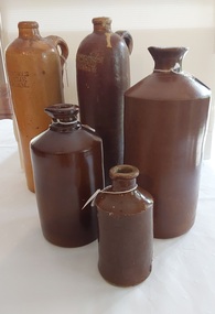 Mont De Lancey
Functional object - Bottles, Unknown
... In fact they actually contained "'Seltzer Spa water' or a form of Quinine Tonic, both supposed to be health drinks. These types of bottles first arrived in Australia with the Gold-seekers from Europe. ...In fact they actually contained "'Seltzer Spa water' or a form of Quinine Tonic, both supposed to be health drinks. These types of bottles first arrived in Australia with the Gold-seekers from Europe. ...These bottles were common in the late 1800's and 1900's. Bottle Nos 1 and 2 were made by Angus & Co, a Sydney company producing ink and gums (glue and clag) from about 1880 to 1920. Their products were sold in stoneware and glass containers in varying sizes. 1. Small pottery bottle referred to as a "Penny Ink" bottle, made by Angus & Co. The small bottle got its name because of the price of 1d. = 1 penny. This bottle is missing. Nos. 3 and 4 The two tall thin Erven Lucas bottles with handles at the top were usually referred to as "Dutch Gins". In fact they actually contained "'Seltzer Spa water' or a form of Quinine Tonic, both supposed to be health drinks. These types of bottles first arrived in Australia with the Gold-seekers from Europe. Early samples are somewhat crudely made. The potter would have formed the bottle with a young apprentice applying the handle, name stamp and the glaze prior to being fired in the kiln. There is evidence of fingerprints from these processes on both samples.A collection of five handmade rare stoneware bottles with a salt glaze: 1. Small pottery bottle referred to as a "Penny Ink" bottle, made by Angus & Co. The small bottle got its name because of the price of 1d. = 1 penny. This is missing. 2. Medium glazed brown pottery bottle with a pouring spout (Angus & Co Ink Commercial). 3. Medium glazed brown pottery bottle with a pouring spout (Bourne Denby). 4. Large glazed brown pottery bottle with a pouring spout (Bourne Denby). Sample is from England probably sold for 2/- or 2/6d. Two shillings or two shillings & sixpence. 5. and 6. Two tall thin brown pottery bottles, one with a broken cork stopper and one without a stopper with Erven Lucas Bols - Het Lootsje Amsterdam stamped at the top of both. They were usually referred to as "Dutch Gins". 6. Green/black bottle is a traditional Dutch Gin with tapering sides, which made it easy to remove from the mold after being blown by hand and the cork top was applied by an apprentice. This sample dates from approximately 1900. Earlier samples are very crude with later samples being machine made with embossing.(This bottle is missing, 13.10.2022). 2. 'Angus & Co Ink Commercial' 3 and 4. 'Bourne Denby' stamped inside an oval lined shape. 5. and 6.Erven Lucas Bols - Het Lootsje Amsterdambeverage bottles, bottles, storage containers, stoneware bottles -
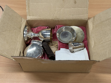 The 5th/6th Battalion Royal Victoria Regiment Historical Collection
Ceremonial object - Communion Kit- Rev J.J. Tresidder
... gold coloured appearence. On the base is a small raised silver cruisifix affixed by a screw. The Chalice was used asa a cup for holding water and wine, drunk from by all as a common cup, beginning and ending with the Priest. 5&6. ...gold coloured appearence. On the base is a small raised silver cruisifix affixed by a screw. The Chalice was used asa a cup for holding water and wine, drunk from by all as a common cup, beginning and ending with the Priest. 5&6. ...Catholic Chaplains Communion kit carried by Rev JJ Tresidder. Rev Tresidder served during the second world war as an Army Chaplian.Catholic Chaplians Communition kit, carried by WW2 chaplain VX117292 John Joseph Tressider. This is an example of the style of equipment, soldiers would have been offered communion from.Communion kit, consisting of 10 items. 1. A white linen Corporal with small red cross embroidered in its centre. This item was used during Mass/ communion/ Lords Supper to collect any host if it were to be dropped, especially after concecration. 2. Pyx. This is a flat circular dish with a hinged lid. On the side of the container is a small silver ball with a hole drilled through it to allow a string to be placed through and the Pyx to be worn around the priests neck. The Pyx is made of silver, and has a cross engraved on the lid. on the reverse " Rev. J.J.Tressider Catholic Chaplain" is enscribed. This item holds individual hosts ( bread) Following Concecration hosts are to be consumed or worn by the Priest and later to be distrubted as reserved sacrement. 3.Paten, a small silver dish, slightly bowing in the centre. There are no engraving on this item except for the makers stamps on the reverse. "T.G. Aunt & Co." " STG. Silver" Use for holding the Priests Host (Bread) representing the body of Christ, broken for all. 4. Chalice. Silver cup with flaired base.The inseide of the cup has a gold coloured appearence. On the base is a small raised silver cruisifix affixed by a screw. The Chalice was used asa a cup for holding water and wine, drunk from by all as a common cup, beginning and ending with the Priest. 5&6. Two silver Cruets. Each crust is a small silver jug with sloping sides with a small pinched lip for pouring. There are no handles and each cruet has the words " Catholic Chaplain" enscribed on its side. One of the cruets is used for adding a small amount of water to the chalice, representing Christs humanity, the outher is used to add a small amount of wine, representing the blood of Christ and divinity. 7. Lavabo Bowl. a small silver bowl with raised sides. The bowl has " Catholic Chaplain" inscribed in the base of the disg. The Lavabo bowl is used to wash the Priests hands prior to celebrating the Mass. 8. Ewer. A small silver water jug with a curled handle. The Ewer has 3 bands engraved arounf its middle and inside has a goldish tint. On its base is stamped "Albion Pla" "EPNS A" The Ewer is used to wash the priests hands prior to Mass. 9. Oil for the infirm- A small sliver canister that can be screwed to two similat canasters. The base has an internal screw thread to allow this to happen. The lid can be screwed on/ off and has an ornate cross enscribed on its top. The side of the canaster has a letter "I" incribed on it filling most of the canasters side. The canaster is believed to still contain the oil. The oil of the infirm is used outside of the mass in a service to administer the sacrement of the anointing of the sick. 10, Leather Oil Carry case, small, chocolate brown tubular carrying case with two snaps for closure on the side. the case has cardboard stiffening and a small amount of cottonwool to soak up any spilt oil. Case is used to carry upto three oil canasters. listed in descriptioncatholic church, 5/6rvr, chaplains kit -
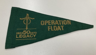 Melbourne Legacy
Flag, Operation Float 1973, 1973
... water or try sailing. This flag was from 1973, the 50th Anniversary year of Legacy. A record of the items and events provided to Junior Legatees. operation float junior legatee outing golden jubilee 50th anniversary Printed in yellow 'Operation Float 1923-1973 Legacy 50'. Small green cloth flag with yellow/gold ...Operation Float was an event run by Melbourne Legacy to take Junior legatees on an outing. It could have been to naval boats such as HMAS Cerberus or to a Yacht club. It gave the junior legatees the opportunity to see a naval boat in action, spend time on the water or try sailing. This flag was from 1973, the 50th Anniversary year of Legacy.A record of the items and events provided to Junior Legatees.Small green cloth flag with yellow/gold text on both sides.Printed in yellow 'Operation Float 1923-1973 Legacy 50'.operation float, junior legatee outing, golden jubilee, 50th anniversary -
Tarnagulla History Archive
Box of Donald Clark's Research Notes, Donald Clark's Research Notes, circa 1960s-2000s
... Within this set are multiple archival folders with the following subject matter: Hotels Gold, prospecting & mining Peace Picnic Street lighting Churches Cemetery Poems Shire of Bet Bet Chinese Clubs Police Transport Local businesses/premises Local people Post Offices Previous history work / previous history enquiries Back To Tarnagulla events Victoria Theatre / Entertainment Schools Water and waterways Early town Mapping and geography Photocopies of photos Miscellaneous Rail Link Centenary Newbridge Eddington Waanyarra Bet bet (town) Llanelly Murphy's Creek / Irishtown Laanecoorie Military Service Fire Brigade Tarnagulla Landmarks / Places of Interest Family Histories Births, Deaths, Marriage info Transcript of St. ...Within this set are multiple archival folders with the following subject matter: Hotels Gold, prospecting & mining Peace Picnic Street lighting Churches Cemetery Poems Shire of Bet Bet Chinese Clubs Police Transport Local businesses/premises Local people Post Offices Previous history work / previous history enquiries Back To Tarnagulla events Victoria Theatre / Entertainment Schools Water and waterways Early town Mapping and geography Photocopies of photos Miscellaneous Rail Link Centenary Newbridge Eddington Waanyarra Bet bet (town) Llanelly Murphy's Creek / Irishtown Laanecoorie Military Service Fire Brigade Tarnagulla Landmarks / Places of Interest Family Histories Births, Deaths, Marriage info Transcript of St. ...Donald Clark Collection. Blue-grey archive box containing research notes of Donald Clark. Within this set are multiple archival folders with the following subject matter: Hotels Gold, prospecting & mining Peace Picnic Street lighting Churches Cemetery Poems Shire of Bet Bet Chinese Clubs Police Transport Local businesses/premises Local people Post Offices Previous history work / previous history enquiries Back To Tarnagulla events Victoria Theatre / Entertainment Schools Water and waterways Early town Mapping and geography Photocopies of photos Miscellaneous Rail Link Centenary Newbridge Eddington Waanyarra Bet bet (town) Llanelly Murphy's Creek / Irishtown Laanecoorie Military Service Fire Brigade Tarnagulla Landmarks / Places of Interest Family Histories Births, Deaths, Marriage info Transcript of St. Saviour's Records A plastic pocket containing duplicate copies of local history images held elsewhere in the collection. The contents of these files were research notes compiled by Donald Clark from his local history research about Tarnagulla and district. tarnagulla & district, donald clark, research -
 Tarnagulla History Archive
Photograph, Gold panners, Tarnagulla, 19th Century
... A monochrome photograph depicting men panning for gold at a stream of water, probably at Sandy Creek (Tarnagulla). ...A monochrome photograph depicting men panning for gold at a stream of water, probably at Sandy Creek (Tarnagulla). ...Donald Clark Collection. A monochrome photograph depicting men panning for gold at a stream of water, probably at Sandy Creek (Tarnagulla). Copy photograph. -
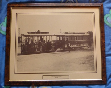 Melbourne Tram Museum
Print - Framed Print, "Cable Tram and Dummy - 1890 - 1900", 1900
... water tank in the background. Cable tram dummy is loaded with gentlemen and there is a paper boy in front of the trailer. Print mounted onto a wooden chip board and sealed with brown tape around the edges. Two screwed frame hanging supports on either side with one run of string between them. Frame - brown and gold...water tank in the background. Cable tram dummy is loaded with gentlemen and there is a paper boy in front of the trailer. Print mounted onto a wooden chip board and sealed with brown tape around the edges. Two screwed frame hanging supports on either side with one run of string between them. Frame - brown and gold ...Framed and glazed photograph of cable tram set, trailer or tram 233, at the Victoria St Terminus, c1900. Has a factory and water tank in the background. Cable tram dummy is loaded with gentlemen and there is a paper boy in front of the trailer. Print mounted onto a wooden chip board and sealed with brown tape around the edges. Two screwed frame hanging supports on either side with one run of string between them. Frame - brown and gold with a buff and black line framed around the photograph. Print has the title "Cable Tram and Dummy - 1890 - 1900". See item 9144 for a postcard of this photo.On rear in ink at the top - "Donated to Hawthorn Tram Museum Feb. 19th 2012 Ron Scholten"trams, tramways, melbourne, victoria st, cable trams, tram 233 -
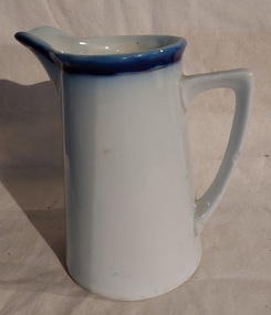 Mont De Lancey
Domestic object - Jug
... water jug in the family home. c.1925. Jugs Containers Domestic objects Kitchenware A medium sized ceramic white jug with a blue band around the top trimmed with a gold line on the rim. ...It was most likely used as a milk or water jug in the family home. c.1925.A medium sized ceramic white jug with a blue band around the top trimmed with a gold line on the rim. jugs, containers, domestic objects, kitchenware -
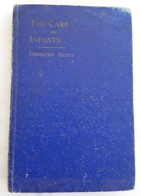 Mont De Lancey
Book, Mellin's Food Co. for Australia & New Zealand, Ltd, The Care of Infants, Unknown
... water and milk and became popular on both sides of the Atlantic. 'Edna L.M. Andrews' is written in blue ink on the top of the right endpaper at the front. A small blue hardcover book with the title printed in gold ...This book gives in-depth information for the care of infants and children from birth. Full details are accompanied by advice for all manner of a child's growth, health and development. Tables such as Suggested Times for Feeding Babies as well as Symptoms of Infectious Diseases of Childhood are included. Who complied this book is not noted, but there is a reference to Mellin's Food Company underneath the publisher on the title page. The recipes refer to Mellin's products too. Melli's Food was an infant food made of wheat flour and malt. It was with both water and milk and became popular on both sides of the Atlantic.A small blue hardcover book with the title printed in gold lettering at the top of the front cover -The Care of Infants. Coronation Edition is printed below. The title page has the title as well as - A Work for Mothers and Nurses in Australasia upon The Feeding and Management of Infants. The publisher details and 1911 are listed at the bottom. The Contents page lists 16 chapters including recipes for children and invalids at the back. There is an Index. Some charts are included. Pp. 112.non-fictionThis book gives in-depth information for the care of infants and children from birth. Full details are accompanied by advice for all manner of a child's growth, health and development. Tables such as Suggested Times for Feeding Babies as well as Symptoms of Infectious Diseases of Childhood are included. Who complied this book is not noted, but there is a reference to Mellin's Food Company underneath the publisher on the title page. The recipes refer to Mellin's products too. Melli's Food was an infant food made of wheat flour and malt. It was with both water and milk and became popular on both sides of the Atlantic.infants, babies, infant care -
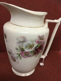 Mont De Lancey
Domestic object - Bedroom Jug, Unknown
... water for washing oneself. Many had a large basin underneath it too, but this one doesn't. Jugs Bedroom jugs Domestic object Functional object 2266 - 2 painted underneath the bottom of jug Large white porcelain bedroom jug with pink and white flowers and green leaves. Fine gold ...From the home of Mrs Wilms. Large jugs were used in bedrooms to contain water for washing oneself. Many had a large basin underneath it too, but this one doesn't.Large white porcelain bedroom jug with pink and white flowers and green leaves. Fine gold lines are around the top and bottom of the jug and on the ornate handle. Numbers 2266 - 2 are painted underneath the bottom of the jug.2266 - 2 painted underneath the bottom of jugjugs, bedroom jugs, domestic object, functional object -
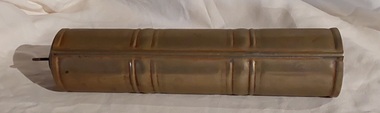 Mont De Lancey
Domestic object - Bed Warmer, Schrade, 1030's - 1950's
... A long vintage gold painted aluminium, cylindrical bed or foot warmer, with a removable brass screw stopper which has a looped handle on top. It has a pattern of four decorative bands around it. It would be filled with hot water...Bed warmers Hot water bottles Patent marks around the screw stopper: 'Schrade Trade Mark Regd Made in Gt. B' A long vintage gold painted aluminium, cylindrical bed or foot warmer, with a removable brass screw stopper which has a looped handle on top. ...1930's to 1950's Schrade 1.2 litre aluminium bed warmer, foot warmer, thermos bottle. It is a bed warmer with a very small opening, but the bottle works effectively on the principle of a thermos bottle. Holds water without leaking.A long vintage gold painted aluminium, cylindrical bed or foot warmer, with a removable brass screw stopper which has a looped handle on top. It has a pattern of four decorative bands around it. It would be filled with hot water, sealed with the stopper and wrapped in a towel or cloth to stop it burning your feet. Patent marks around the screw stopper: 'Schrade Trade Mark Regd Made in Gt. B'bed warmers, hot water bottles -
 Mont De Lancey
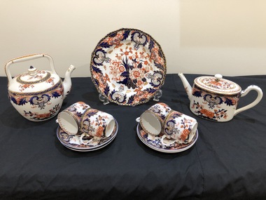
China Tea Set, Staffordshire
... gold trim. Pieces included - four teacups, four saucers, one round lidded teapot, one hanging plate one oval lidded water kettle. ...gold trim. Pieces included - four teacups, four saucers, one round lidded teapot, one hanging plate one oval lidded water kettle. ...From Robyn Johnston12 piece blue and orange floral Royal Staffordshire tea set with gold trim. Pieces included - four teacups, four saucers, one round lidded teapot, one hanging plate one oval lidded water kettle. All pieces are numbered on the base. Gold painted crown with Staffordshire name below. All pieces have 7500 number on base.tea sets -
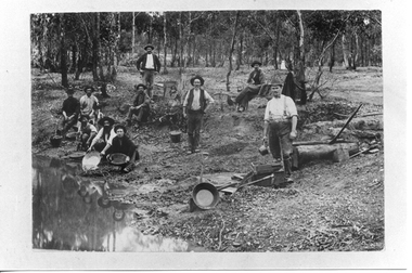
 Linton and District Historical Society Inc
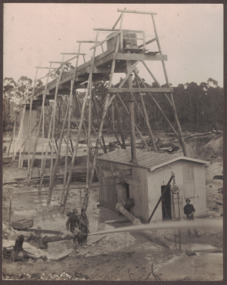
Photograph, Electro Hydraulic Dredge, Snake Valley, 1909
... These dredges were used for getting gold. The streams of water under high pressure just washed the hills and ground away. ...Between 1904 and 1911 the Electro Hydraulic Company sought to extract gold in an area north of Linton known as the Hard Hills. By blasting water from high-pressure hoses into the hillsides, soil containing gold was washed out for sluicing. ...These dredges were used for getting gold. The streams of water under high pressure just washed the hills and ground away. ...Electro hydraulic dredge Snake Valley 1909. J Mc Bennett, was an engineer back at the main base, at Dawson's dam on the Carngham Road, Between Linton and Snake Valley. These dredges were used for getting gold. The streams of water under high pressure just washed the hills and ground away. This dredge closed down early 1910. 200 H.P. motors were used and 10 in. pumps.Black and white image of three workmen, one beside mining building the other two at dredge pump outlet. Image mounted on dark brown card. Between 1904 and 1911 the Electro Hydraulic Company sought to extract gold in an area north of Linton known as the Hard Hills. By blasting water from high-pressure hoses into the hillsides, soil containing gold was washed out for sluicing. Two gravel pumps in Dawson's Dam pumped the wash through the sluices. Despite considerable investment in expensive equipment, the Company did not have a great deal of success, and the mining operation ceased in 1911.mining, gold, mining equipment, electro hydraulic dredge, dredging, sluicing, dawson's dam, snake valley, miners -
 Linton and District Historical Society Inc
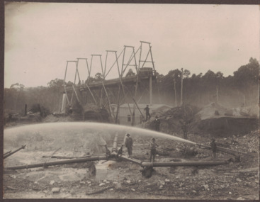
Photograph, Electro Hydraulic Dredge, Snake Valley, 1909
... These dredges were used for getting gold. The streams of water under high pressure just washed the hills and ground away. ...These dredges were used for getting gold. The streams of water under high pressure just washed the hills and ground away. ...Black and white image of workmen at electro hydraulic dredge Snake Valley mine site. Image has been mounted on dark brown card. Electro hydraulic dredge Snake Valley Victoria 1909. J.M.C. Bennett was an engineer back at the main base, at Dawson's Dam on the Carngham Road, bet Linton and Snake Valley. These dredges were used for getting gold. The streams of water under high pressure just washed the hills and ground away. This dredge closed down early 1910. 200 H.P. Motors were used and 10 in. pumps.electro hydraulic dredge, dredging, sluicing, mining, gold, miners, mining equipment, snake valley -
 Linton and District Historical Society Inc
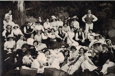
Photograph, Picnic at Dawson's Dam
... Water from the dam was used in 'sluicing' by the Electro Hydraulic Company - water was blasted from high pressure pumps onto hillsides some distance away, to wash out dirt containing gold. ...Water from the dam was used in 'sluicing' by the Electro Hydraulic Company - water was blasted from high pressure pumps onto hillsides some distance away, to wash out dirt containing gold. ...Dawson's Dam was between Linton and Snake Valley. Water from the dam was used in 'sluicing' by the Electro Hydraulic Company - water was blasted from high pressure pumps onto hillsides some distance away, to wash out dirt containing gold. Sluicing operations ceased around 1911 and the dam became a popular picnic spot.Large, framed, black and white photograph of a group of people sitting or lying down, with picnic baskets in bush setting."This photo is from the collection of Mrs Jessie Black (nee Walker) born Linton 11 July 1909. She said it was taken at Dawson's Dam near Linton, and was a picnic but we don't know of which group of people. The only person in it known to the family is the man in the hat, at front right, who was Daniel Hogan, Jessie's uncle, born 1886 in Linton. Given by Jill Wheeler, great niece of Daniel Hogan, October 2008."dawson's dam, picnics, jessie walker, daniel hogan, jill wheeler, jessie black -
Linton and District Historical Society Inc
Mining company registration form, Water Right for Devils Kitchen Gold Mining Company
... Water Right for Devils Kitchen Gold Mining Company ...Gold mining... Mining companies... Court of Mines... Registration forms... Shareholders... Water...The page is numbered "269" at the top left. Water Right for Devils Kitchen Gold Mining Company Mining company registration form ...The page lists information about water rights granted to the Devil's Kitchen GMC, which was operating at Springdallah - registration number (329), date of registration (2nd March 1863), location of the claim, nature of the water right, source of the water supply, site of dams and number of sluice heads, names of shareholders and their mining right numbers, and transfers of share ownership. This page also includes the registration of a mine operated by Curson and Partner at Dreamer's Hill (registration number 329/2). Very few details about this mine are recorded on the form, other than the names of the two business partners and location of the mine.A3 size photocopy of a page which has probably come from a register of mining companies, most likely maintained at the Smythesdale Court of Mines or another local Court of Mines. (The actual source of the document is not known.) The page is numbered "269" at the top left.gold mining, mining companies, court of mines, registration forms, shareholders, water rights, springdallah, dreamer's hill, devil's kitchen gold mining company, roger evans, henry orr, jas k. davies, arthur j. curson, john burke, documents and records, mining company registers -
Linton and District Historical Society Inc
Mining company registration form, Water Right for Lyndock Company
... Gold mining... Mining companies... Court of Mines... Registration forms... Shareholders... Water...The page lists information about water rights granted to the Lyndock Company, a gold mining company which was operating at Coffee Hill near Linton. ...Linton and District Historical Society Inc 69 Sussex Street Linton 3360 goldfields The page lists information about water rights granted to the Lyndock Company, a gold mining company which was operating at Coffee Hill near Linton. ...The page lists information about water rights granted to the Lyndock Company, a gold mining company which was operating at Coffee Hill near Linton. Information includes registration number (169), date of registration (16th January 1862), location of the claim, nature of the water right, source of the water supply, site of dams, names of shareholders and their mining right numbers.A3 size photocopy of a page which has probably come from a register of mining companies, most likely maintained at the Smythesdale Court of Mines or another local Court of Mines. (The actual source of the document is not known.) The page is numbered "19" at the top left.gold mining, mining companies, court of mines, registration forms, shareholders, water rights, coffee hill (linton), snake valley, smith's gully, james hill, samuel knight, george lowe, edward wenders (winders?), ambrose grose, henry pascoe, daniel mcintyre, john mayne, documents and records, mining company registers -
 Flagstaff Hill Maritime Museum and Village
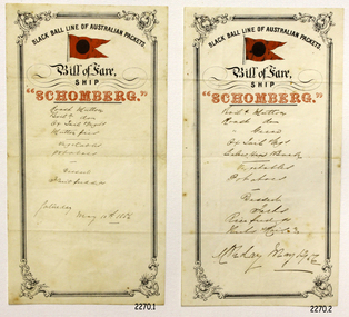
Document - Menu, Bill of Fare ship Schomberg, circa 1855 - May 12 1856
... water.” SCHOMBERG’s owners, the Black Ball Line (one of three companies by that name), commissioned the ship for their fleet of passenger liners. She was built by Alexander Hall of Aberdeen, UK at a cost of £43,103. She was constructed with 3 skins: one planked fore and aft, and two diagonally planked, fastened together with screw threaded trunnels (wooden rails). Her first class accommodation was luxurious: velvet pile carpets; large mirrors; rosewood; birds-eye maple; mahogany; soft furnishings of gold...water.” SCHOMBERG’s owners, the Black Ball Line (one of three companies by that name), commissioned the ship for their fleet of passenger liners. She was built by Alexander Hall of Aberdeen, UK at a cost of £43,103. She was constructed with 3 skins: one planked fore and aft, and two diagonally planked, fastened together with screw threaded trunnels (wooden rails). Her first class accommodation was luxurious: velvet pile carpets; large mirrors; rosewood; birds-eye maple; mahogany; soft furnishings of gold ...A “Bill of Fare” is a menu or list of food offered for a meal. This Bill of Fare from the sailing ship Schomberg is handwritten in pen in hard-to-read script on the printed pages specifically for the Schomberg ship, of the Black Ball Line of Australian Packets. (‘Packets’ were vessels that had a regular trade run of cargo, passengers and mail; the sailing ship Schomberg was designed for long voyages between England and Australia.) These menus posed a puzzle as they have the handwritten dates of, May 10 and 12, 1856, by which time the Schomberg had sunk (she sunk on December 26, 1855). The donor of these pages of Bill of Fare is a stamp collector from Melbourne. He came across the menus in a package that he bought in 1980 at a stamp auction in Tasmania. He decided to give the menus to Flagstaff Hill this year during his annual family holiday in Warrnambool. A 1981 newspaper article about this donation included an interview with Flagstaff Hill’s curator Mr Peter Ronald, who said that the stationery of these menus is genuine. He went on to say that there would have been much stationery printed for use on the Schomberg although she sank on her maiden voyage. These menus could have been written at a dated late because the surplus Schomberg stationery could have been used for menus on other ships. We will probably never be sure of the answer but none-the-less the pages are still connected to the Schomberg. Below is what we believe the menu consists of although some of the writing is indecipherable - - - - - - - - - - - - - - - - - - - - - - - - - - - - - - - - - - - - - (first menu) Roast Mutton Boiled Mutton? Ox Tail Mulligatawny? Or possibly Ox Tail Vegetables? Mutton Pies? ------------------------------- Vegetables Potatoes ---------------------------------- Dessert Fruit Puddings? Saturday May 10, 1856 - - - - - - - - - - - - - - - - - - - - - - - - - - - - - - - - - - - - AND - - - - - - - - - - - - - - - - - - - - - - - - - - - - - - - - - - - - (second menu) Boiled Mutton Roast Mutton? Roast Geese? Ox Tail?? Calves Head Broth? ------------------------------- Vegetables Potatoes ------------------------------- Dessert Tarts? Rice Pudding? ?...Maids?? Monday May 12, 1856 - - - - - - - - - - - - - - - - - - - - - - - - - - - - - - - - - - - - Background of “SCHOMBERG” When SCHOMBERG was launched in July, 1855, she was considered the “Noblest ship that ever floated on water.” SCHOMBERG’s owners, the Black Ball Line (one of three companies by that name), commissioned the ship for their fleet of passenger liners. She was built by Alexander Hall of Aberdeen, UK at a cost of £43,103. She was constructed with 3 skins: one planked fore and aft, and two diagonally planked, fastened together with screw threaded trunnels (wooden rails). Her first class accommodation was luxurious: velvet pile carpets; large mirrors; rosewood; birds-eye maple; mahogany; soft furnishings of gold satin damask; an oak-lined library; and a piano. Overall she had accommodation for 1000 passengers. SCHOMBERG’s 34 year old master, Captain James ‘Bully’ Forbes, had promised Melbourne in 60 days at the launch, "with or without the help of God." James Nicol Forbes was born in Aberdeen in 1821 and rose to fame with his record-breaking voyages on the famous Black Ball Line ships MARCO POLO and LIGHTNING. In 1852 in the MARCO POLO he made the record passage from London to Melbourne in 68 days. There were 53 deaths on the voyage but the great news was of the record passage by the master. In 1954 Captain Forbes took the clipper LIGHTNING to Melbourne in 76 days and back in 63 days, this was never beaten by a sailing ship. He often drove his crew and ship to breaking point to beat his own records. He cared little for the comfort of the passengers. On this, the SCHOMBERG’s maiden voyage, he was going to break records. SCHOMBERG departed Liverpool on her maiden voyage on 6 October 1855 flying the sign “Sixty Days to Melbourne”. She departed with 430 passengers and 3000 tons cargo including iron rails and equipment intended to build the Melbourne to Geelong Railway as well as a bridge over the Yarra from Melbourne to Hawthorn. She also carried a cow for fresh milk, pens for fowls and pigs, and 90,000 gallons of water for washing and drinking. SCHOMBERG also carried 17,000 letters and 31,800 newspapers. The ship and cargo was insured for $300,000, a fortune for the time. The winds were poor as she sailed across the equator, slowing SCHOMBERG’s journey considerably. Land was first sighted on Christmas Day, at Cape Bridgewater near Portland, and Captain Forbes followed the coastline towards Melbourne. Forbes was said to be playing cards when called by the Third Mate Henry Keen, who reported land about 3 miles off. Due in large part to Forbes regarding a card game as more important than his ship, SCHOMBERG eventually ran aground on a sand spit near Curdie's Inlet (about 56 km west of Cape Otway) on 26 December 1855, 78 days after leaving Liverpool. The sand spit and the currents were not marked on Forbes’s map. Overnight, the crew launched a lifeboat to find a safe place to land the ship’s passengers. The scouting party returned to SCHOMBERG and advised Forbes that it was best to wait until morning because the rough seas could easily overturn the small lifeboats. The ship’s Chief Officer spotted the steamer SS QUEEN at dawn and signalled it. The master of the SS QUEEN approached the stranded vessel and all of SCHOMBERG’s passengers and crew were able to disembark safely. The SCHOMBERG was lost and with her, Forbes’ reputation. The Black Ball Line’s Melbourne agent sent a steamer to retrieve the passengers’ baggage from the SCHOMBERG. Other steamers helped unload her cargo until the weather changed and prevented the salvage teams from accessing the ship. Later one plunderer found a case of Wellington boots, but alas, all were for the left foot! Local merchants Manifold & Bostock bought the wreck and cargo, but did not attempt to salvage the cargo still on board the ship. They eventually sold it on to a Melbourne businessman and two seafarers. In 1864 salvage efforts were abandoned after two men drowned when they tried to reach SCHOMBERG. Parts of the SCHOMBERG were washed ashore on the south island of New Zealand in 1870, nearly 15 years after the wreck. The wreck of the SCHOMBERG lies in almost 9 metres of water. Although the woodwork is mostly disintegrated, the shape of the ship can still be seen due to the remaining railway irons, girders and the ship’s frame. A variety of goods and materials can be seen surrounding the wreck, by divers. Flagstaff Hill holds many items salvaged from the SCHOMBERG including a ciborium (in which a diamond ring was concealed in concretion), communion set, ship fittings and equipment, personal effects, a lithograph, tickets and photograph from the SCHOMBERG. These Bills of Fare are significant due to their connection to Flagstaff Hill’s collection of artefacts from the Schomberg, which is significant for its association with the Victorian Heritage Registered shipwreck S612. The collection is primarily significant because of the relationship between the objects, as together they have a high potential to interpret the story of the Schomberg. The Schomberg collection is archaeologically significant as the remains of an international passenger ship. The shipwreck collection is historically significant for representing aspects of Victoria’s shipping history and its potential to interpret sub-theme 1.5 of Victoria’s Framework of Historical Themes (living with natural processes). The collection is also historically significant for its association with the shipwreck and the ship, which was designed to be fastest and most luxurious of its day. The Schomberg collection meets the following criteria for assessment: Criterion A: Importance to the course, or pattern, of Victoria’s cultural history. Criterion B: Possession of uncommon, rare or endangered aspects of Victoria’s cultural history. Criterion C: Potential to yield information that will contribute to an understanding of Victoria’s cultural history. Menu, or Bill of Fare, on cream coloured stationery from the sailing vessel “Schomberg”. Two rectangular pieces of paper, each bears the printed words “Black Ball Line of Australian Packets, Bill of Fare, Ship, Schomberg”, a printed symbol of the Black Ball line (a black ball on a red flag) and a decorative border. Both pages are handwritten, in similar but different sized writing, with a Bill of Fare and a date, Page (1) dated May 10th 1856 and (2) dated May 12th ’56, (Both dates are AFTER the Schomberg sank in December 26th 1855.) Both pages have three fold lines spaced across their width. To be used for the return voyage.Printed on the pages ““BLACK BALL LINE OF AUSTRALIAN PACKETS.” “Bill of Fare, / SHIP / “SCHOMBERG”.” Handwritten list of food, and on one page “Saturday May 10 1856” and on the other page “Monday May 12” warrnambool, peterborough, shipwrecked coast, shipwreck coast, flagstaff hill maritime museum, flagstaff hill maritime village, maritime museum, great ocean road, flagstaff hill, sailing ship schomberg, shipwreck schomberg, black ball line of australian packets, bill of fare schomberg, menu schomberg 1856, food mid-1800’s, food on ships mid-1800’s, menu, may 10, 1856, may 12, 1856 -
 Great Stupa of Universal Compassion
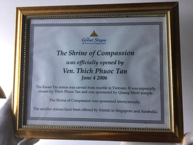
Certificate (item) - Framed certificate of the opening of Shrine of Compassion, 04/06/2006
... Depicted holding a vase containing sacred water, symbolising compassion and healing, she is believed to hear the cries of the world and respond with kindness and guidance. holy objects buddhist art statues The Great Stupa of Universal Compassion (logo); the text: "The Shrine of Compassion was officially opened by Ven. Thich Phuoc Tan June 4 2006". Printed certificate on paper, in a gold ...The certificate commemorates the official opening of the Shrine of Compassion, which houses the large statue of Kwan Yin carved from marble in Vietnam. The statue was especially chosen by Ven. Thich Phuoc Tan and sponsored by Quang Minh temple. The Shrine of Compassion is located in the Great Stupa's Peace Park. Kwan Yin (also known as Quan Yin or Guanyin) is revered as the Goddess of Mercy in Chinese Buddhist tradition. Depicted holding a vase containing sacred water, symbolising compassion and healing, she is believed to hear the cries of the world and respond with kindness and guidance.The Great Stupa of Universal Compassion (logo); the text: "The Shrine of Compassion was officially opened by Ven. Thich Phuoc Tan June 4 2006".holy objects, buddhist art, statues -
 Bendigo Historical Society Inc.
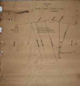
Plan - North Golden Fleece Lease, unknown
... Gold Mine Ramrod Reef Comet Reef Stafford Reef and Frying Pan Reef Map drawn on heavy paper, titled 'Section of North Golden Fleece lease'. Scale 80 ft to 1 inch. Written on plan in black print: 'This belt of country contains large bodies of auriferous quartz and at present is being operated on by the New Golden Fleece Company'. Reef lines marked on plan: Ramrod Reef, Comet Reef, Stafford Reef and Frying Pan Reef. The water ...Map drawn on heavy paper, titled 'Section of North Golden Fleece lease'. Scale 80 ft to 1 inch. Written on plan in black print: 'This belt of country contains large bodies of auriferous quartz and at present is being operated on by the New Golden Fleece Company'. Reef lines marked on plan: Ramrod Reef, Comet Reef, Stafford Reef and Frying Pan Reef. The water race, Albert shaft and open cut are marked at the surface level. This plan is part of the Margaret Roberts Collection. north golden fleece gold mine, gold mining, bendigo, lease holding, albert gold mine, ramrod reef, comet reef, stafford reef and frying pan reef -
 Bendigo Historical Society Inc.
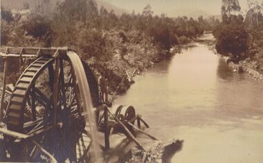
Photograph - PHOTO OF WATER WHEEL, 1900
... Sepia Toned Photograph, gold sluicing on the Ovens River near Germantown) Showing a man standing on a water wheel looking over a water course flanked by trees & shrubbery with mountains in the background. ...PHOTOGRAPH water wheel landscape Water Wheel Mining N.J. Caire Sepia Toned Photograph, gold sluicing on the Ovens River near Germantown) Showing a man standing on a water wheel looking over a water course flanked by trees & shrubbery with mountains in the background. ...Sepia Toned Photograph, gold sluicing on the Ovens River near Germantown) Showing a man standing on a water wheel looking over a water course flanked by trees & shrubbery with mountains in the background. Markings on rear Photo read 'N.J. Caire Landscape Photographer 4 Darling Street South Yarra Victoria'N.J. Cairephotograph, water wheel landscape, water wheel, mining -
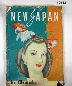 Bendigo Military Museum
Magazine - NEW JAPAN, Noburw Ozaki, 15 Dec 1947
... Two gold fish are above her with a water weed. The background colours are green and orange. ...Two gold fish are above her with a water weed. The background colours are green and orange. ...Item collected by "Alva Bennetts" during her deployment to BCOF - 1947-1949. Part of the Bennetts collection. See Cat 9726P for details of service for Alva Marie Bennetts, (VFX128835).Large format magazine. The front image is a painting showing a "Western" Lady with a green tinted face. Two gold fish are above her with a water weed. The background colours are green and orange. Internally is a mixture of written, post WW2 articles, advertising and photographs of occupation troops and Japanese people. It has 176 pages.alva bennetts, bennetts collection, bcof, japan, newspaper article