Showing 11430 items
matching maps
-
 Bendigo Historical Society Inc.
Document - J W SWATTON COLLECTION: MAP OF NEW SOUTH WALES
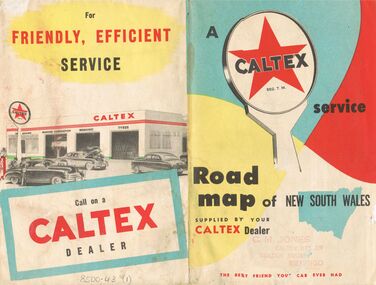
Two Road maps of New South Wales. C M Jones, Caltex Dealer, Golden Square, Bendigo stamped on the front. Map shows Sydney Outlet Roads, City of Sydney, City of canberra, Newcastle District, Motor tours Around Sydney, Routes to Brisbane, Road Map of New South Wales. It also lists the Principal Towns with Distances from Sydney and Interstate Road Mileages including Sydney to Melbourne via Hume Highway, Prince's Highway, via Canberra & Bombala. Also Sydney to Adelaide via Hume & Sturt Highways, Sydney to Brisbane via New England Highway, Pacific Highway via Toowoomba and Sydney to Adelaide via Western, Mid-Western and Sturt Highways.person, receipts, j w swatton, j w swatton collection, road map of new south wales, caltex, c m jones, e s sculley, clive barrass -
 Bendigo Historical Society Inc.
Book - STREET AND ROAD MAPS OF THE CITY OF BENDIGO BOROUGH OF EAGLEHAWK, c1980
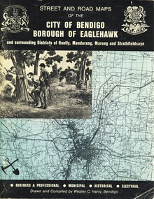
Street and Road Maps of the City of Bendigo Borough of Eaglehawk and surrounding Districts of Huntly, Mandurang, Marong and Strathfieldsaye, in color. Drawn and compiled by Wesley C Harry, Bendigo. Publisher: Cambridge Press, Bendigo. ISBN: 9598608.2.2. 68 pages. Photographs, Illustrations & maps. Photos include: Bendigo buildings, scenery mines, streetscapes, parades, pioneer leaders of Bendigo. Many advertisements throughout. List of Justices of the Peace, hospitals, homes for the aged, schools, churches. Page 58: Copy of ''Freedom of the City to the Australian Survey Regiment'' proclamation, 14th June 1970. Maps cover an area of some 169 sq. miles (43,772 hectares). Origin of the name Bendigo. Information on the five Wards of Bendigo, and their councilors. Revised Edition 1986Wesley C Harrybook, bendigo, bendigo & district maps, bendigo and districts map, buildings, streetscapes, historical pictures, advertisements, historical information, commisioners camp, sandhurst -
 Southern Sherbrooke Historical Society Inc.
Photograph - 9 hole golf course-Belgrave Heights 1930-1943 map
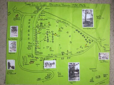
Hand drawn map of Belgrave Heights and its 9 hole golf course, between 1930 and 1943 created by Betty de Coite nee Woods, who holidayed in the area with her family. Map drawn in marker. Photographs attached, including a view of the golf course, Fern Glade Tracks, Lockwood Rd, the dam at Marama Rd corner, The Crescent, the path near the club house, and a wagon near golf course. These photos were taken by members of the Woods family. Map highlights Lockwood House at the corner of Lockwood Rd, the 9 hole golf course, and Sunnyside guesthouse. Club house at Lockwood Rd is later the site of the Convention Centre. Above club house is Fred and Ruby Cook's House. -
 Eltham District Historical Society Inc
Document - Property Binder, 810 Main Road, Eltham
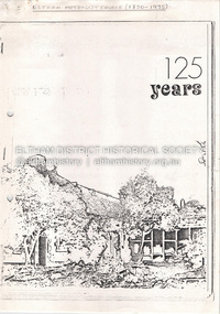
Photocopy publication: Eltham Methodist Church One Hundred and Twenty-Five Years 1850-1975, Chris Allan editor. History of early Eltham, railway, schools, churches by A Bird. Map of Eltham with sites of significant buildings. Maps church site. Plan of church. Reminiscences by Edna Bill, Val Gangell, Don Brown. Notes by Ken Eckersall, Peter Gray, Ron Hubery. Newspaper article: Lessons in history, Diamond Valley News, 2 August 2000. Newspaper article: Parents stop teachers, Diamond Valley News, 2 August 2000, State-wide preschool teachers strike and Hurstbridge pre-school.main road, eltham, eltham methodist church, eltham uniting church, josiah holloway, hurstbridge pre-school, kinglake national park, churches -
 Glen Eira Historical Society
Article - Howitt Family
Photocopied extract on ‘The Howitt Family of Barragunda’ from ‘Early Pioneer Families of Victoria and Riverina’ includes black photos of family. Handwritten family tree – source unknown. Two handwritten foolscap sheets with extracts from Caulfield Rate Books, 1857-1891 where Howitt is listed as owner of properties, records tenants, addresses, size of property and value. Typewritten notes on the biography of Dr. Godfrey Howitt, outlines qualifications, endowments, interest, membership, no map included – it says Foot Survey Map. Howitt, Alfred William, typed and handwritten notes, references to house. Notes on publications written by Howitts, and the roles they undertook.bakewell, millman william, howitt godfrey dr., howitt john henry, howitt richard, howitt phoebe, mrs. nee godfrey bakwell, howitt william, howitt edward, howitt charles ernest, howitt edith mary, howitt alfred william, burke and wills expedition, king john, ‘rosemont’ kooyong rd, melbourne university, pioneer, botanist, naturalist, squatters, doctors, crotonhurst rd, caulfield, kooyong rd west, balaclava rd west, eyre rd, hume rd, howitt thomas, tantum phoebe, boothby benjamin judge, botham mary, millman william, mcwilliams robert, blake arthur palmer, grice james, spretchley edward, mcnaughton goerge, campbell john a., serle w.h., howitt mary, mickle royal society of victoria, st. mary’s church of england caulfield, stables, slab huts, police magistrate, authors -
 Glen Eira Historical Society
Map - Cantala
Six pages of handwritten notes, undated and unattributed, detailing the history of the subdivision and demolition of Cantala, Dandenong Road, 40, Caulfield. The notes, which include a list of references, detail the main auction on 21/05/1938 and prices paid for the allotments. Also included in the file are photocopies of three auction posters for the 21/05/1938 auction in 32 allotments. Two of the posters are small and one of these includes a map (107mm x 110mm) of the Cantala Estate. The other poster is spread across three A4 pages and includes a map and plan (204mm x 110mm) of the allotments. There is an extra copy of the final page of this larger poster.miller septimus, miller helen m, mcintyre angus, miller n a, crouch h c, cantala, dandenong road, wiora, alma road, waiora road, findon avenue, cantala avenue, caulfield, caulfield north, st kilda east, yeo grosthwaite and co, abercromby and beatty pty ltd, mansions, land subdivision, house auctions, auctioneers, land sales, land values, architectural features, gardens, advertisements, racehorses, road construction and maintenance, surveyors, lawyers, minute books, trams -
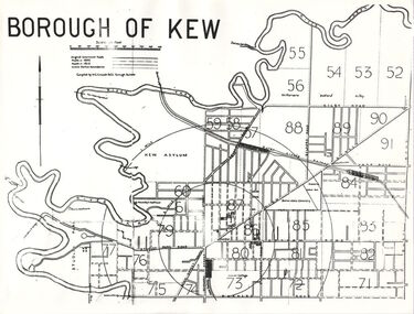 Kew Historical Society Inc
Plan, Borough of Kew, 1910
This work forms part of the collection assembled by the historian Dorothy Rogers, that was donated to the Kew Historical Society by her son John Rogers in 2015. The manuscripts, photographs, maps, and documents were sourced by her from both family and local collections or produced as references for her print publications. Many were directly used by Rogers in writing ‘Lovely Old Homes of Kew’ (1961) and 'A History of Kew' (1973), or the numerous articles on local history that she produced for suburban newspapers. Most of the photographs in the collection include detailed annotations in her hand. The overhead transparency is of a map produced by H.C. Crouch Borough Surveyor in 1910The Rogers Collection provides a comprehensive insight into the working habits of a historian in the 1960s and 1970s. Together it forms the largest privately-donated collection within the archives of the Kew Historical Society.An overhead transparency of a plan of Kew comparing the roads in 1860 with later roads constructed by 1910. Sections of the plan are marked with the location of particular buildings, farms or transport routes.Borough of Kewborough of kew, h.c. crouch -
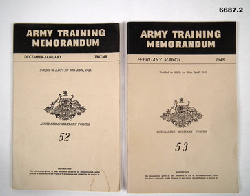 Bendigo Military Museum
Booklet - BOOKLETS, ARMY TRAINING MEMORANDUM No. 52 & 53, Aust Army, 1948
1. This is a cardboard covered booklet. Khaki coloured cover, black printing. It has the title at the top, khaki on a black bar. December - January 1947-48. No.52. It has the crest of Australia in the centre. Australian Military Forces. The booklet is fastened with 2 staples. Includes 60 pages, maps, photos and drawings. 2. Same type of booklet as No. 1, except now its February-March 1948, No.53. 66 pages with maps, drawings and photos.1. Inside the cover is - 333-T-2. 2. Inside the cover is - 333-T-3.passchendaele barracks trust, army information, amf -
 Kiewa Valley Historical Society
Leaflet - Kiewa, Welcome to Kiewa
The State Electricity Commission of Victoria constructed the Kiewa Hydro Electric Scheme from 1938 to 1961. The Scheme included three power stations, dams, tunnels and was becoming a popular tourist destination with Falls Creek Ski field within its boundaries.This leaflet was published by the SECV to ensure all visitors to the Kiewa Hydro Electric Scheme were made aware of safety measures with regard to their driving and to bush fires. These were necessary as the area was unique with driving on mountainous roads, changeable and extreme weather and the threat of bush fires. The gatehouse existed during construction, when the SECV was in charge, as a restriction to entry to the Scheme for SECV workers and those with permission to enter. The SECV controlled the area so in case of accident, the SECV was the body to contact not eg. the police.Small white and green leaflet made from one sheet of glossy paper and folded in half. Front cover has the title in the middle, the SECV emblem at the centre top and across the bottom is a message to read the inside pages which are safety messages for driving and bush fires. The back cover has a RACV road map of Kiewa and its 'works' including the Gatehouse which was the entrance to the scheme.The map also has an insert of the main roads & nearby cities. state electricity commission of victoria; kiewa hydro electric scheme; gatehouse; safety rules; kiewa -
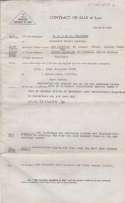 Bendigo Historical Society Inc.
Document - H. A. & S. R. WILKINSON COLLECTION: CONTRACT OF SALE
Contract of sale of land dated 10th December, 1952 between Mrs. A. Baggaley & Mr. A. Baggaley (vendor) and Mrs. A. M. Smyth (purchaser). Property: land delineated and coloured red on the map endorsed hereon part of allotment 23 section 3B Parish of Sandhurst City of Bendigo, land described in conveyance No. 619 book 495, together with all buildings thereon with a right of carriage way over the land coloured brown on the map. Price: 1,950 pounds.organization, business, h.a. & s.r wilkinson real estate -
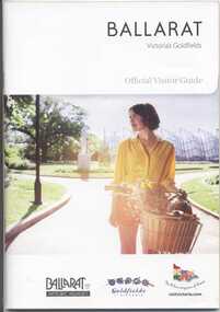 Ballarat Tramway Museum
Book, The Ballarat Visitor Information Centre, "Ballarat Victoria's goldfields Official Visitor Guide", 2012
Full colour, 100 page, book, A5 size titled "Ballarat Victoria's goldfields Official Visitor Guide", with an autumn view across Lake Wendouree. Gives details, maps accommodation listing, attractions etc of the Ballarat area. Page 13 detail the Ballarat Tramway Museum and the BTM advertisement on page 23. Inside rear cover is a fold out map of the district, city centre, Ballarat and Surrounds. Published 2012 by The Ballarat Visitor Information Centre. trams, tramways, ballarat, visitors, tourist guides, btm, gardens -
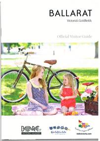 Ballarat Tramway Museum
Book, The Ballarat Visitor Information Centre, "Ballarat Victoria's goldfields Official Visitor Guide", 2014
Full colour, 92 page, book, A5 size titled "Ballarat Victoria's goldfields Official Visitor Guide", with a photo of a lady and child with a bicycle behind. Gives details, maps accommodation listing, attractions etc of the Ballarat area. Page 16 detail the Ballarat Tramway Museum. Inside rear cover is a fold out map of the district, city centre, Buninyong and Mt Helen and Ballarat and Surrounds. Published 2014 by The Ballarat Visitor Information Centre. trams, tramways, ballarat, visitors, tourist guides, btm, gardens -
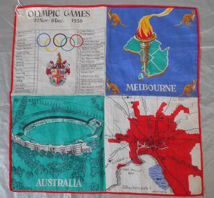 Bendigo Historical Society Inc.
Textile - 1956 Olympics Ladies' handkerchief
The 1956 Summer Olympics, officially known as the Games of the XVI Olympiad, were an international multi-sport event held in Melbourne, Victoria, Australia, from 22 November to 8 December 1956, with the exception of the equestrian events, which were held in Stockholm, Sweden, in June 1956. These Games were the first to be staged in the Southern Hemisphere and Oceania, as well as the first to be held outside Europe and North America. Handkerchief produced as a souvenir for the 1956 Melbourne Olympics. Synthetic fabric. The handkerchief s bordered in red thread and divided into four squares of contrasting colours. 1. A table of main events and ceremonies, Olympic rings and symbol. 2. Map of Australia (green) with an Olympic torch and kangaroos in each corner. 3 An image of the main stadium. caption "AUSTRALIA" in white on a green background. 4. Map of Melbourne in red with connecting road and rail links to other parts of Victoria. 1956 olympics, handkerchief -
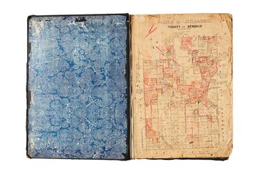 City of Greater Bendigo - Civic Collection
Administrative record - Land Sales, A. J. Mullet Government Printer, 1927
This type of album was created by agents auctioning and selling land.Large portfolio style album with black cloth cover bound with three large metal pins. Blue marbled pastedown endpapers. Seventy nine pages, seventy five with Department of Lands and Survey maps attached. No index page. Maps have handwritten notes and markings throughout in pencil and pen. Covers the Counties of Bendigo, Rodney, Gladstone and Talbot and Parishes of Kerang, Salisbury, Mandurang and Tarnagulla. Includes a hand written note on William Wallace & Co letterhead. city of bendigo commerce -
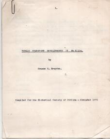 Melbourne Tram Museum
Document - Report, Graeme Breydon, "Public Transport Developments in St Kilda", Nov. 1970
Carbon copy of a report - 10 quarto pages + two heat sensitive copied maps titled "Public Transport Developments in St Kilda", prepared by Graeme Breydon Nov 1970 for the Historical Society of St Kilda. Looks at the development of tram transport, cable trams, railways, Hobson's Bay loop line, electrocution of the railways and tramways, some features e.g. shelters, developments and freeway proposals. Maps show rail and tramways on the eastern side of Melbourne.trams, tramways, city of st kilda, victorian railways, pmtt, vr, st kilda brighton, construction, railways, cable trams -
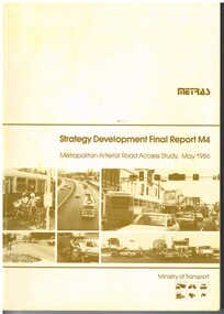 Melbourne Tram Museum
Document - Report, Ministry of Transport, "METRAS - Strategy Development Final Report M4 - Metropolitan Arterial Road Access Study, May. 1986
Report - 198 pages - perfect bound +card covers + fold out maps and charts, looks at the development of arterial roads in the various Melbourne regions, includes recommendations, funding, Punt Road, management. Has table of contents, diagrams and maps. Includes findings of the studies, issues with freight transport, improvement proposals. Little work on public transport as such. Title - "METRAS - Strategy Development Final Report M4 - Metropolitan Arterial Road Access Study - May 1986"has pen marks alongside some paragraphs or underneath headings in the recommendations section.trams, tramways, public transport, road transport, minister for transport -
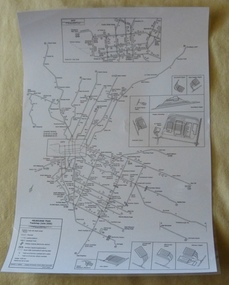 Melbourne Tram Museum
Poster, P. Sohns, "Melbourne Tram Track map (June 2006)", 2006
Poster - titled "Melbourne Tram Track map (June 2006)", line drawing on white paper, showing a detailed track map of junctions, depots, cross overs, route numbers, Preston Workshop, track out of service but overhead still in place, routes under construction of planning. Prepared by P. Sohns with Research by H. Waldron. Dated 8/4/2006. Has a detailed inserted of the city area. One unlaminated and one laminated copy held.trams, tramways, melbourne, map, tramways, depots, workshops, tram routes -
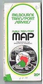 Melbourne Tram Museum
Map, Ministry of Transport, "Melbourne Transport Services Map - Tram, Train and Bus Services", 1975-1976
Fold out map (27 sections 9 across x 3 deep), coloured of Melbourne's Tram and Bus routes, route numbers, rail lines, detailed for the central part of Melbourne and insert section for Frankston. On rear description of routes, private bus routes and map of Melbourne metro lines. Has contact details for bookings and lost property etc. Priced 20c possible 1975-1976 - has 1041 and silver train on front cover.On front cover in ink "3" in top right hand corner and "4 G 33 " along bottom edge.trams, tramways, melbourne, map, tram & bus services, railways, mmtb, minister for transport -
 Bendigo Military Museum
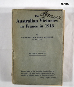
Book - FRANCE, ARMY WW1, Lieutenant General Sir John Monash, "THE AUSTRALIAN VICTORIES IN FRANCE IN 1918", First edition 1920, Second revised edition 1923. 1928
From the front cover; "Intense pride in the Australian Soldier glow in/ this book Sir John doubts whether there is any/ parallel in military history to their performance"/ Daily Graphic (London)." Part of the "William (Bill) THOMASON" Collection. Refer Cat. No. 4136P for more items.Soft cover book. Cover - cardboard, mid grey colour with dark blue colour print on front and back. Black colour print on spine. 336 pages - cut, plain, white colour paper. Illustrated - front end papers - black and red print map of a battle. Back end papers - black and red print map of a campaign. Handwritten signature - front cover and second page from front, price notation - top of page.Handwritten signature - black ink pens - illegible. Price notation - grey lead pencil - "$ 30c"publications, books, ww1, france, monash, william (bill) thomason -
 Bendigo Military Museum
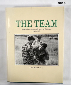
Book - VIETNAM, Ian McNEILL, "THE TEAM", 1984
From the Title page - "THE TEAM/ AUSTRALIAN ARMY ADVISERS/ IN VIETNAM 1962-1972" Part of the "William (Bill) THOMASON" Collection. Refer Cat No. 4136P for more items.Hardcover book with dust cover. Cover - cardboard, green colour buckram, gold colour print on spine. Dustcover - paper, green and black colour print on front and spine on cream colour background. Front illustration - black and white photograph of three soldiers. Flaps with black print information. 534 pages - cut, plain, white colour paper. Illustrated black and white photographs and maps. End papers - front and back - brown beige colour map.publications, books, vietnam, army, william (bill) thomason collection -
 Bendigo Historical Society Inc.
Map - K. K. MINE - TRANSVERSE SECTION K. K. MINE
Transverse Section of the K. K. Mine on the Hustler's Line of Reefs, Bulletin No 33, Plate No XXXII. Map shows the different levels and their depth. Also, the different types of stone encountered and geological features such as spurs and faults. Has drawing of the poppet legs at the top of the shaft and sill of shaft 773.56 ft above sea level. Map has Geological Survey of Victoria crest and signed by H S Whitelaw, Underground Survey Office Bendigo, September 1913. miners, fortuna hustler's mine, transverse section of k. k. mine, hustler's line of reefs, geological survey of victoria, h s whitelaw -
Glen Eira Historical Society
Document - Nithsdale
Photocopied copy of flyer for forthcoming subdivision of Caulfield Heights Estate on 27/10/1888. Includes locality plan and subdivisions. Photocopied copy of flyer for forthcoming sale of properties and mansion, Nithsdale on 18/09/1889, includes map of area.carriages and coaches, caulfield heights estate, caulfield north, maxwell grove, kambrook road, neerim road, blake street, bambra road, racecourse road, auctioneers, station street, glen eira road, paynes j., mansion, beauchamp brothers -
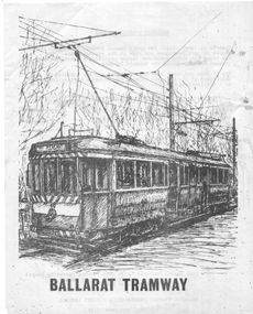 Ballarat Tramway Museum
Pamphlet - advertising the Museum, Ballarat Tramway Preservation Society (BTPS), 1975
Pamphlet advertising the Museum, with a sketch of tram 40, with the name "Ballarat Tourist Tramway" on the rear and giving visiting details and fares. Has a map on the rear showing the location and track along Wendouee Parade. See item 6296 for an earlier example. Yields information about BTPS Marketing c1975.Duplicated quarto sheet two sided on white paper.tramways, ballarat, btps, map, drawings, sketches, fares, operations -
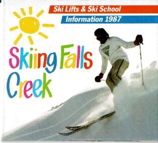 Falls Creek Historical Society
Booklet - Skiing Falls Creek, Information 1987
Part of a yearly marketing and information material promoting Falls Creek ski region for the winter holidays. This is a small fold out guide to ski lifts, tariffs, ski runs and a map of Falls Creek. It also includes basic safety instructions.This item is important as it documents seasonal activities at Falls Creek Alpine ResortA small fold out guide to ski lifts and Ski School at Falls Creekskiing, falls creek, school holidays, winter, falls creek marketing -
Tatura Irrigation & Wartime Camps Museum
Photographs, Girshik family, 1943
Photos taken within Camp 3. Nine photos of Camp 3 life, including the Girshik family and Monsignor Apostolic Delegate. Six photos including map of British entry into Persia & Helga Griffin addressing the Historical Society 2006.camp 3 -
 Orbost & District Historical Society
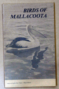
book, Birds of Mallacoota 1979, August 1979
This book was produced at the Mallacoota Central School. Bruce Pascoe wrote the introduction for the book. He was teaching at Mallacoota.This book is a valuable reference book which is used by ornithologists to compare recordings of bird sightings in Mallacoota.A small 52 pp book titled Birds of Mallacoota 1979. On the front cover is a photo of a pelican at Coull's Point, Mallacoota. The photo was taken by Wayne Stevens. The title is in black. It contains photographs and maps.book birds mallacoota pascoe-bruce -
 Orbost & District Historical Society
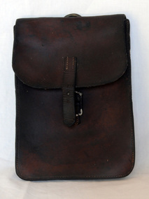
document bag, Early 20th century
A brown leather document/map bag. It is envelope style with a rusted silver coloured buckle. On the back is a silver coloured metal ring to attach to a saddle. The flap has a small strap to close the buckle.leather-case document-holder -
 Ringwood and District Historical Society
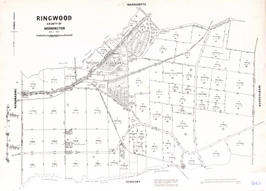
Map - Parish of Ringwood, County of Mornington, Victoria, Original Land Owners
Laminated Parish map of Ringwood detailing original Land Owners' names, property locations and acreages. Details reproduced in 1957 by the Department of Lands and Survey, Melbourne, from original surveys of varying dates. -
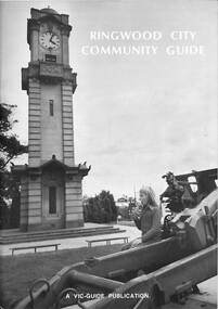 Ringwood and District Historical Society
Book, Ringwood City Community Guide (1976-77), 1976
Ringwood Community Guide containing Council editorial, brief history of Ringwood, local Community Services and Business Listings. Also includes a street directory map of Ringwood Municipality, and a 1976-1977 Calendar."First Edition". "Front cover photograph: Memorial Clock Tower erected in 1928."rinx -
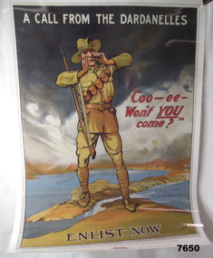 Bendigo Military Museum
Poster - ENLISTMENT POSTER, St. Leigh & Co. Ltd, Original WW1
A commemorative poster facsimile of an original WW1 Recruitment Poster issued in 1915 by Defence Department - Issued by Australian Geographic.Large hard paper poster. Symbolic image of Australian Soldier standing on a 3D image of the Dardenelles in Turkey. In colour showing map of that part of Turkey. Poster laminated with layer of clear plastic to protect it.On top says "A CALL FROM THE DARDENELLES" On bottom "ENLIST NOW" In middle "COO-EE - WON'T YOU COME"ww1, recruitment poster