Showing 23422 items
matching emu-creek
-
 Eltham District Historical Society Inc
Slide, Grand Parade, Eltham Community Festival, 17 Oct. 1981
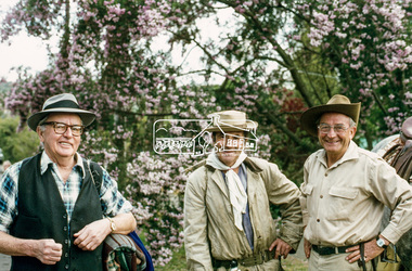
The 1981 Eltham Community Festival was held from 16th to 18th October, with the festival parade being held on Saturday 17th. In recent years the Society had participated in the parade and a display for the festival, winning prizes for the Society’s float in 1979, 1980 and again in 1981 with a prize for the best effort by a local group, donated by Bob Clarke's Menswear. Peter Quirke provided the use of his truck as a float. Peter had formerly operated his fruiterer's business at Research and Diamond Creek and in 1981 opened a shop in the Eltham Village Arcade. Joh Ebeli, with assistance from other members decorated the float. Members of the Victorian Folk Music Club accompanied the Society on the float and their music helped create the appropriate mood. A new feature of the Society’s 1981 parade entry was the inclusion of horse drawn vehicles owned and driven by the Hennel family of Hurstbridge, which added to a highly successful day. Society member and long-time Eltham resident, Jock Read also won an award for the “Best Eltham Theme.” Jock and his horse were a feature of Eltham parades for many years and he also established a local tradition in leading Anzac Day parades. 35 mm colour positive transparency (1 of 5) Mount - Agfachrome Agfa CS System black 8 dotseltham festival, parade, parade floats, pioneers of eltham, shire of eltham historical society, cecil street, garnet burges, jack hodson, jock read -
 Eltham District Historical Society Inc
Slide, Grand Parade, Eltham Community Festival, 17 Oct. 1981
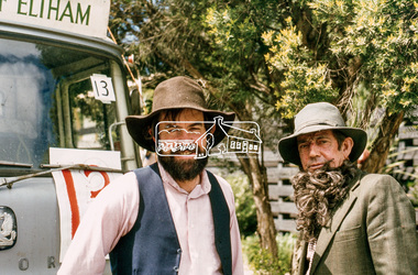
The 1981 Eltham Community Festival was held from 16th to 18th October, with the festival parade being held on Saturday 17th. In recent years the Society had participated in the parade and a display for the festival, winning prizes for the Society’s float in 1979, 1980 and again in 1981 with a prize for the best effort by a local group, donated by Bob Clarke's Menswear. Peter Quirke provided the use of his truck as a float. Peter had formerly operated his fruiterer's business at Research and Diamond Creek and in 1981 opened a shop in the Eltham Village Arcade. Joh Ebeli, with assistance from other members decorated the float. Members of the Victorian Folk Music Club accompanied the Society on the float and their music helped create the appropriate mood. A new feature of the Society’s 1981 parade entry was the inclusion of horse drawn vehicles owned and driven by the Hennel family of Hurstbridge, which added to a highly successful day. Society member and long-time Eltham resident, Jock Read also won an award for the “Best Eltham Theme.” Jock and his horse were a feature of Eltham parades for many years and he also established a local tradition in leading Anzac Day parades. 35 mm colour positive transparency (1 of 5) Mount - Agfachrome Agfa CS System black 8 dotseltham festival, parade, parade floats, pioneers of eltham, shire of eltham historical society, cecil street, russell yeoman, bruce ness -
 Eltham District Historical Society Inc
Slide, Grand Parade, Eltham Community Festival, 17 Oct. 1981
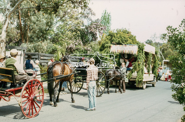
The 1981 Eltham Community Festival was held from 16th to 18th October, with the festival parade being held on Saturday 17th. In recent years the Society had participated in the parade and a display for the festival, winning prizes for the Society’s float in 1979, 1980 and again in 1981 with a prize for the best effort by a local group, donated by Bob Clarke's Menswear. Peter Quirke provided the use of his truck as a float. Peter had formerly operated his fruiterer's business at Research and Diamond Creek and in 1981 opened a shop in the Eltham Village Arcade. Joh Ebeli, with assistance from other members decorated the float. Members of the Victorian Folk Music Club accompanied the Society on the float and their music helped create the appropriate mood. A new feature of the Society’s 1981 parade entry was the inclusion of horse drawn vehicles owned and driven by the Hennel family of Hurstbridge, which added to a highly successful day. Society member and long-time Eltham resident, Jock Read also won an award for the “Best Eltham Theme.” Jock and his horse were a feature of Eltham parades for many years and he also established a local tradition in leading Anzac Day parades. 35 mm colour positive transparency (1 of 5) Mount - Agfachrome Agfa CS System black 8 dotseltham festival, parade, parade floats, pioneers of eltham, shire of eltham historical society, cecil street, victorian folk music club -
 Eltham District Historical Society Inc
Slide, Grand Parade, Eltham Community Festival, 17 Oct. 1981
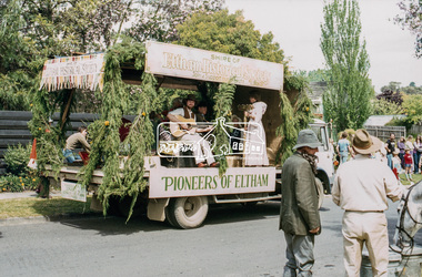
The 1981 Eltham Community Festival was held from 16th to 18th October, with the festival parade being held on Saturday 17th. In recent years the Society had participated in the parade and a display for the festival, winning prizes for the Society’s float in 1979, 1980 and again in 1981 with a prize for the best effort by a local group, donated by Bob Clarke's Menswear. Peter Quirke provided the use of his truck as a float. Peter had formerly operated his fruiterer's business at Research and Diamond Creek and in 1981 opened a shop in the Eltham Village Arcade. Joh Ebeli, with assistance from other members decorated the float. Members of the Victorian Folk Music Club accompanied the Society on the float and their music helped create the appropriate mood. A new feature of the Society’s 1981 parade entry was the inclusion of horse drawn vehicles owned and driven by the Hennel family of Hurstbridge, which added to a highly successful day. Society member and long-time Eltham resident, Jock Read also won an award for the “Best Eltham Theme.” Jock and his horse were a feature of Eltham parades for many years and he also established a local tradition in leading Anzac Day parades. 35 mm colour positive transparency (1 of 5) Mount - Agfachrome Agfa CS System black 8 dotseltham festival, parade, parade floats, pioneers of eltham, shire of eltham historical society, cecil street, victorian folk music club -
 Eltham District Historical Society Inc
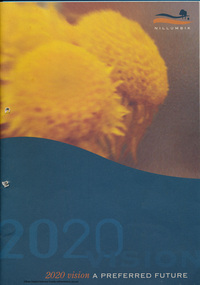
Booklet - Folder, 2020 Vision: a preferred future, 1984
Following council amalgamations, a series of community consultations were undertaken in 1995 to inform the development of a cohesive vision for the newly formed Shire of Nillumbik. A response to the new conditions which people of the Eltham/Diamond Creek/Greensborough and surrounding rural areas found themselves in as a result of the decision by the Victorian Government to amalgamate local governments into larger entities. The case for these reforms was strong, but the amalgamation process did disrupt some people's lives.The need to bring together the people within the new boundaries of Nillumbik was recognised by the Commissioners and the Chief Executive Officer of the Shire, who felt that a good way to begin was to develop a future vision for the Shire. It was decided that the people of the Shire should be asked what they wanted their future to be and a process of consultation was established through which people could express their views. Contents: Part One: Introduction, Nillumbik 1995 -what we thought, Nillumbik - thinking the future, Creatng a Nillumbik Community, Nillumbik's assets, Goals for Nillumbik 2020. Part Two: A sustainable society, population and density, the built environment, town and community centres, transport, agriculture, rural Nillumbik, Arts and cultural activity, the younger generation, Nillumbik's elders, planning for the disabled and health and well-being.40 pagesharry gilham collection, shire of nillumbik, vision, consultation, planning -
 Eltham District Historical Society Inc
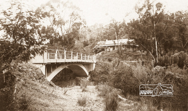
Photograph - Postcard, The Bridge, Hurstbridge, Vic
Arched Bridge (Monash Bridge) The Rose Series P. 4036 Reproduced in a brochure advertising the "Wattle Valley Estate" 7 minutes from the bridge. The new bridge designed by Sir John Monash over the Diamond Creek near Hurst's original home "Mia Mia" seen in the distance. The Wattle Valley Estate was first advertised in August 1925 as weekend building allotments by the Greater Melbourne Land and Development Company. Advertised from £28.10.0 or £60 per block. In August 1926, 30 picked allotments of 60x150 feet were put up for auction Saturday August 14, 1926 with frontages to Valley View Road and Fawkner Crescent advertised in the “Heart of the Glorious Wattle Country” and “Within 15 Minutes of the Newly Electrified Railway Station”. The Advertiser on August 13, 1926 in an article promoting the auction stated “the estate is regarded as one of the best in the district, and will be sold practically without reserve.” It is noted that an advertisement running in The Argus February 22, 1951 offered the remaining 16 blocks for sale at £12.10.0 or £200 the lot. By March 7, the remaining blocks were advertised at £17.10.0 The Wattle Valley Estate took over 20 years to sell and then people could not build on them.Digital file only Postcards scanned from the collection of Michael Aitken on loan to EDHS, 13 Feb 2018michael aitken collection, postcards, hurstbridge, monash bridge, bridge, diamond creek (creek), mia mia, shire of eltham pioneers photograph collection, wattle valley estate -
 Federation University Historical Collection
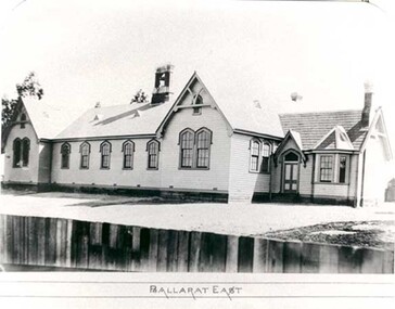
Photograph - Photograph - black and white, Ballarat East State School (No 1071)
The weatherboard Ballarat East State School SS 1071 was formerly known as Specimen Hill. According to 'Visions and Realisations' The Eureka gold lead opened in August 1852, running from Little Bendigo, south beneath Yarrowee Creek into Pennyweight flat, where it was joined 100 yards or so from the intersection of main and Eureka Streets by the Canadian Lead. State School 1071 was formerly known as Ballarat Common School No. 71, and was founded by the Free Presbyterian Church on Specimen Hill in Eureka Street, Ballarat on 01 January 1854. On 20 May 1869 the trustees of the Presbyterian School, Specimen Hill, Ballarat, consented to the transfer of the site to the Board of Education. On 01 September 1870, Specimen Hill, Ballarat, was vested in the Board and then became known as SS 1071. On 01 March 1879 the Minister, The Hon. William Collard Smith, and William Dobbie, Inspector of School Buildings, visited Ballarat to report on the buildings with a view to extensions and renovations. The minister issued instructions for the old wooden part of the school to be demolished, and brick additions to be erected, so that the whole premises would accommodate 350 students. (''Visions and Realisations: A Century of State Education in Victoria, Vol. 2'', Education Department of Victoria, 1973, p 729-730.)Black and white photograph of a weatherboard school with shingle roof known as Ballarat East (SS1071). The building has a brick chimney and bell tower. This school has Castlemaine flagging in the passages.ballarat east state school, education, st paul's school, specimen hill state school -
 Puffing Billy Railway
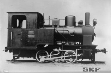
Steam Locomotive, Orenstein & Koppel 0-6-0 Well Tank 2'6" Gauge, 1931
Sub Nigel Gold Mines No. 3 Wheels: 0-6-0 WT Builder: Orenstein & Koppel Build Date: June 1931 Construction No.: 12331 Empty Weight: 10 tons 7 cwt Weight in working order: 12 I/2 tons Driver Diameter: Unknown Tractive Effort: Unknown Boiler Pressure: 185 lbs Cylinders: Unknown Fuel: Coal Gauge: 2 ft 6 in (760mm) Builders Number 12331 Used to haul gold bearing ore from mine to reduction works at the Sub Nigel Mine at Dunnattar, Transvaal, South Africa. It was the first locomotive fitted by roller bearings by SKF and featured in the SKF catalogue at the time. This interesting 0-6-0WT locomotive was built by Orenstein & Koppel in 1931 as their builder's number 12331, becoming No.3 in the locomotive fleet at the Sub Nigel Gold Mines Ltd, South Africa. No.3 was obtained by the Puffing Billy Preservation Society and imported to Australia in the early 1970s. It arrived at the museum on 30th Jan 1973. It has since been displayed at the Puffing Billy Museum, Menzies Creek. Details from http://www.australiansteam.com/ok12331.htm Donated by Gold Fields Property Co. Ltd South Africa in 1973.Historic - Industrial Narrow Gauge railway - Steam Locomotive with SKF Roller bearings - used at the Sub Nigel Mine at Dunnattar, Transvaal, South Africa.Steam Locomotive - Steel (Painted)The Sub Nigel Ltd / 12331puffing billy, steam, locomotive, orenstein, koppel, sub nigel mine, skf roller bearings, sub nigel no. 3 -
 Bendigo Historical Society Inc.
Book - Wells Family scrapbook
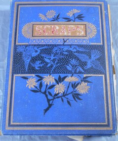
George Edwin Wells was born in Oxford in 1826. He served an apprenticeship as a coachbuilder and in 1841 he went to New Zealand. He was returning to England in 1848 when he changed his mind in Singapore and turned around and came to Melbourne. He operated a store with Mr W Gibbs and when gold as discovered they left their wives in Melbourne and went to the gold fields of Ballarat in 1851. At this time George was newly married to Catherine Kiely. In 1852 the two men were at the Golden Gully area of the Fryers Creek gold fields, they then move to Bendigo, initially to White Hills before settling in Long Gully. They then brought their patient wives, who had only had visits from their husbands, to Bendigo. George had several successful mining ventures in Bendigo. He died in 1898. One of his sons, Alfred, married Margaret Rotherham in NSW where he was living. Alfred died in 1911 leaving Margaret with a young family. She moved to Bendigo to be nearer to family support. Alfred and Margaret's daughter, Elma Winslade Wells 91904 - 19/1/1988) became a teacher and was posted to Camp Hill Primary School. She was also heavily involved in the Scout movement in the Bendigo area.Blue hardcover scrapbook belonging to the Wells family. (Elma Wells). The cover has gold, black and blue flowers and birds on it. The word "scraps" in red within a gold rectangular box completes the cover. Inside all the pages are filled with drawing and pictures of people, animals, flowers and landscapes. Also, various poems are transcribed on the pages. Newspaper cuttings are also glued to pages and in two yellow envelopes.Inside cover in pencil: The Wells Family scrap book donated to the Royal Historical Society Bendigo Branch by Miss Elma W. Wellsfamily history, wells family -
 Surrey Hills Historical Society Collection
Photograph, Surrey Hills Golf Club - the cutting in (now) Whitehorse Road, 1905, 1905
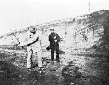
Reproduced by permission of Mr John Arnold from his book: "The Riversdale Golf Club - a history, 1892-1977." Copyright to book: Riversdale Golf Club. Surrey Hills Golf Club operated from 1892-1908 then moved and became Riversdale Golf Club. The game was played across paddocks from Trafalgar Street, Mont Albert to Whitehorse Road and down Victoria Crescent to where Box Hill TAFE is now located in Elgar Road. There were problems with cows eating the tee flags! The clubhouse still exists as 30 Trafalgar Street. The men are standing on what is now Whitehorse Road in the cutting which can still be seen near the Box Hill Motel. Walter John Carre Riddell: Born c1859; died 12 March 1930; unmarried. Father came from Riddell in Scotland and took up land at Riddell's Creek, near Gisborne. W J Carre Riddell was educated at Melbourne Grammar, graduated in law from Melbourne University in 1882 and practised law until 1907. MLA for West Bourke for 17 years. Chairman of MMBW from 1907 until retirement in 1927. Versatile sportsman. REF: Obituary in Trove - The Argus, 13 March, 1930, p8.The image is significant for its association with Walter John Carre Riddell who was a significant identity in early 20th century Melbourne. His was well-known for his sporting prowess. In early life he was a keen footballer, cricketer and tennis player. In his later years he took up golf. Was President of Royal Melbourne Golf Club and Chairman of the Victorian Golf Association. The 'coffin hole' was a notoriously difficult position to play out from.Black and white photo of 2 men, one swinging his golf club; the other carrying a golf bag and watching. They are dressed in suits and hats and are standing in a cutting, the face of which shows rock strata."W. J. Carre Riddell playing out of the coffin, 1905."sports grounds, surrey hills golf club, riversdale golf club, jon arnold, w j carre-riddell, walter john carre riddell -
 National Wool Museum
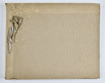
Album - Photo Album, 2 of 3, J W Allen, 1928-1929
This album is one of three albums compiled and owned by J W Allen, Secretary of New South Wales Grazier's, and is associated with the New South Wales Graziers Association world tour of sheep 1928-1929. This album contains photographs of travel, sheep, farms, stations, people and landscapes from around the world. Locations include Kenya, Kinangop, Naivasha, Elementeita, Lake Nakuru, Njoro, Namibia, Otjihavera, Mt Kenya, Isiolo, Yemen, Aden, Suez, River Jordan, Jerusalem, Hebron, Bethlehem, Beersheba, Galilee, Lake Tiberias, Mt Hermon, Canada, Mt Robson, Fraser River Canyon, British Columbia, Merrit, Canford, Alberta, Cardston, Pekisko Creek, Turner Valley, Calgary, Saskatoon, Manitoba, Winnipeg, Portage la Prairie, Niagara Falls, Quebec, Sainte-Anne-de-la-Pocatière and St Lawrence River. Properties depicted include Kenton Estates, Kekopey Ranch, Soysambu Ranch, Larmudiac, SX Ranch, Neilson's Ranch, EP Ranch and CX Ranch. The album was found in a clean out at the Great Southern Agricultural Research Institute and donated to the National Wool Museum, along with other related material such as photographs, glass lantern slides and ephemera.Photo album with card cover and silk string binding. Inside are twenty four pages of brown carded paper with black and white photos and hand written black text. A white piece of paper with hand written text has been added to the inside front page.new south wales graziers association, world tour, sheep, farm, rural, agriculture, ranch, travel, kenton estates, kekopey ranch, soysambu ranch, larmudiac, sx ranch, neilson's ranch, ep ranch, cx ranch, kenya, kinangop, naivasha, elementeita, lake nakuru, njoro, namibia, otjihavera, mt kenya, isiolo, yemen, aden, suez, river jordan, jerusalem, hebron, bethlehem, beersheba, galilee, lake tiberias, mt hermon, canada, mt robson, fraser river canyon, british columbia, merrit, canford, alberta, cardston, turner valley, pekisko creek, calgary, saskatoon, manitoba, winnipeg, portage la prairie, niagara falls, quebec, sainte-anne-de-la-pocatiere, st lawrence river -
 National Wool Museum
Photograph - Karakul Sheep, J W Allen, 1928-1929
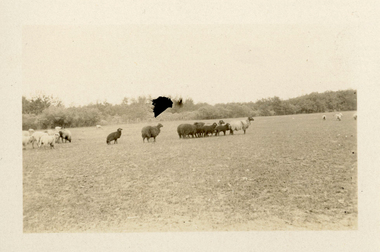
This photograph was found loose in the second of three albums compiled and owned by J W Allen, Secretary of New South Wales Grazier's, and is associated with the New South Wales Graziers Association world tour of sheep 1928-1929. The album contains photographs of travel, sheep, farms, stations, people and landscapes from around the world. Locations include Kenya, Kinangop, Naivasha, Elementeita, Lake Nakuru, Njoro, Namibia, Otjihavera, Mt Kenya, Isiolo, Yemen, Aden, Suez, River Jordan, Jerusalem, Hebron, Bethlehem, Beersheba, Galilee, Lake Tiberias, Mt Hermon, Canada, Mt Robson, Fraser River Canyon, British Columbia, Merrit, Canford, Alberta, Cardston, Pekisko Creek, Turner Valley, Calgary, Saskatoon, Manitoba, Winnipeg, Portage la Prairie, Niagara Falls, Quebec, Sainte-Anne-de-la-Pocatière and St Lawrence River. Properties depicted include Kenton Estates, Kekopey Ranch, Soysambu Ranch, Larmudiac, SX Ranch, Neilson's Ranch, EP Ranch and CX Ranch. The album was found in a clean out at the Great Southern Agricultural Research Institute and donated to the National Wool Museum, along with other related material such as photographs, glass lantern slides and ephemera.Black and white image showing sheep in a paddock.world tour, sheep, graziers, photograph, karakul, winnipeg, canada, manitoba, agriculture -
 National Wool Museum
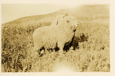
Photograph - 'Harvey' Ram at Neilson's Ranch, J W Allen, 1928-1929
This photograph was found loose in the second of three albums compiled and owned by J W Allen, Secretary of New South Wales Grazier's, and is associated with the New South Wales Graziers Association world tour of sheep 1928-1929. The album contains photographs of travel, sheep, farms, stations, people and landscapes from around the world. Locations include Kenya, Kinangop, Naivasha, Elementeita, Lake Nakuru, Njoro, Namibia, Otjihavera, Mt Kenya, Isiolo, Yemen, Aden, Suez, River Jordan, Jerusalem, Hebron, Bethlehem, Beersheba, Galilee, Lake Tiberias, Mt Hermon, Canada, Mt Robson, Fraser River Canyon, British Columbia, Merrit, Canford, Alberta, Cardston, Pekisko Creek, Turner Valley, Calgary, Saskatoon, Manitoba, Winnipeg, Portage la Prairie, Niagara Falls, Quebec, Sainte-Anne-de-la-Pocatière and St Lawrence River. Properties depicted include Kenton Estates, Kekopey Ranch, Soysambu Ranch, Larmudiac, SX Ranch, Neilson's Ranch, EP Ranch and CX Ranch. The album was found in a clean out at the Great Southern Agricultural Research Institute and donated to the National Wool Museum, along with other related material such as photographs, glass lantern slides and ephemera.Black and white image showing a man and a sheep in the foreground with mountains in the background.Back: [handwritten] Harvey ram / at Neilson’s / Harvey / Neilson’s ranch [printed] A 40world tour, sheep, graziers, photograph, canada, agriculture, cardtson, alberta -
 National Wool Museum
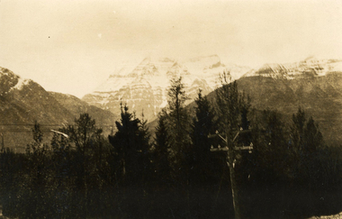
Photograph - Mount Robson, J W Allen, 1928-1929
This photograph was found loose in the second of three albums compiled and owned by J W Allen, Secretary of New South Wales Grazier's, and is associated with the New South Wales Graziers Association world tour of sheep 1928-1929. The album contains photographs of travel, sheep, farms, stations, people and landscapes from around the world. Locations include Kenya, Kinangop, Naivasha, Elementeita, Lake Nakuru, Njoro, Namibia, Otjihavera, Mt Kenya, Isiolo, Yemen, Aden, Suez, River Jordan, Jerusalem, Hebron, Bethlehem, Beersheba, Galilee, Lake Tiberias, Mt Hermon, Canada, Mt Robson, Fraser River Canyon, British Columbia, Merrit, Canford, Alberta, Cardston, Pekisko Creek, Turner Valley, Calgary, Saskatoon, Manitoba, Winnipeg, Portage la Prairie, Niagara Falls, Quebec, Sainte-Anne-de-la-Pocatière and St Lawrence River. Properties depicted include Kenton Estates, Kekopey Ranch, Soysambu Ranch, Larmudiac, SX Ranch, Neilson's Ranch, EP Ranch and CX Ranch. The album was found in a clean out at the Great Southern Agricultural Research Institute and donated to the National Wool Museum, along with other related material such as photographs, glass lantern slides and ephemera.Black and white image showing trees, power pole and power lines in the foreground and snow covered mountains in the background. world tour, sheep, graziers, photograph, canada, agriculture, british columbia, mount robson, mt robson -
 Falls Creek Historical Society
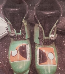
Equipment - SCOTT Ski Boots
The sport of skiing was revolutionized with a technical innovation from Ed Scott. His invention of the first tapered aluminium ski pole immediately replaced the sport's existing use of bamboo and steel. One of Ed Scott’s key associates was Charley French, a former aeronautical engineer who began working with him in Sun Valley, Idaho, USA in 1970. The first project that tackled together was to improve the design of ski boots. From there they progressed to ski goggles. This led to the design of goggles for motorcross. For Charley a natural progression led to the development of the aerodynamic handlebar and mountain bike suspension systems. In 1997, the SCOTT company introduced a technical winter sport apparel line and in 1998 was also producing skis. In 2009 their new Crusair quickly became the benchmark ski for the freeride mountaineering market. SCOTT continue to be innovators for the development of sports equipment and their designs are often worn by champions in skiing, cycling and athletics. These boots were donated by Julian Newton Brown. Stickers were attached to advertise his lodge at Falls Creek. The boots were lightweight allowing a lot of ankle flex, and good support when turning due to stiff cuffs. This type of boot was popular with free skiers.These boots are significant because they demonstrate a stage in the evolving technology of designs for the ski sport industry and also bear the sticker of Julian's Lodge, an iconic business in Falls Creek, Victoria.Lime green plastic, single clip racing boot.Sticker on front of both boots: Julian's Lodgeski equipment, ski boot design, scott ski products, julian's lodge, julian newton brown -
 Falls Creek Historical Society
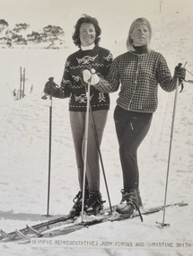
Photograph - Olympic Representatives Judy Forras and Christine Smith
Judith (Judy) Forras and Christine Smith both represented Australia at the 1964 Winter Olympics in Innsbruck. Judy was a National Ice-Skating champion before becoming an Olympic Alpine Skier. She had already won the Victorian skating title she met her future husband Ernest Forras, owner of the Kooroora Chalet and ski instructor at Mt. Buller. After having four children, Judy came back to skiing, winning every major State and National Title in all three disciplines, Slalom, Downhill and Giant Slalom, therefore gaining automatic selection to the Olympic team for Innsbruck in 1964. The only other Australian woman selected to that team was Christine Smith. She was born in Cooma NSW, Christine learned to ski at an early age. She won the 1961 NSW Junior Champion title before being selected in the Australian Team to ski against New Zealand. Christine gained selection for the 1962 St. Moritz Commonwealth Winter Games. In the 1964 Innsbruck Olympic Winter Games she placed 27th in the Downhill and 28th in the Slalom. Before departing for Innsbruck, members of the team including Ross Milne, completed some of their training at Falls Creek, Victoria where this photograph was taken.This image is significant because it represents two women who were pioneers in the Winter Olympic movement in Australia.A black and white image showing two female skiers, representatives of the Australian Winter Olympic team of 1964.winter olympics innsbruck, judy forras, christine smith -
 Falls Creek Historical Society
Photograph - Bogong Alpine Village 1940
The images in the Bogong Village Collection were displayed in Bogong Jack’s Tavern for over 20 years and were donated to the Falls Creek Museum by the Liz Krien & the Bogong Village Trust Board when the Tavern closed in 2021. In 1939, the State Electricity Commission of Victoria established a field headquarters at Bogong to house workers and their families for the Kiewa Hydroelectric Scheme which ran from the 1930s to the 1960s. The workmen's camp was originally started with tents and was called Junction Camp. By 1947, the village supported 300 workers and their families. It included 40 houses, a hostel for single staff, a post office, a police station, a medical centre, and a primary school. The staff hostel was known as Kiewa House. At the completion of the Scheme, in the 1960s, the village was opened to public/tourism use. In 1968 the Victorian Education Department acquired the camp buildings and four houses from the State Electricity Commission of Victoria to establish an Outdoor Education Centre which operated for over 50 years. The Kiewa Hydroelectric Scheme was privatized in the 1990s and sold to Southern Hydro, before being acquired by AGL in 2005. In 2023 the Grollo Group signed a 73 year sublease on Bogong Village and has plans for its redevelopment as a workers’ village.These images are significant because they capture the development of Bogong Village as an important element of the Kiewa Hydroelectric Scheme in Victoria.A collection of 10 black and white images capturing the development of Bogong Alpine Village. They depict development of the new village, the surrounding area and some staff members during 1940.bogong alpine village, bogong 1940, bogong high plains -
 Falls Creek Historical Society
Functional object - Peacock Hand Warmers
These mid-1960s Peacock and Gold brand lighter fuel hand warmers were used in Falls Creek to keep out the cold. The concept behind the hand warmer is that through combustion (ignition) of lighter fluid (light petrol distillate) it becomes a catalytic heater, relying on a catalysed chemical reaction to break down molecules and create heat. The devices could get quite hot, not hot enough to set paper on fire, but hot enough to give a nasty burn if sustained contact against your skin occurred. The construction of the device is very simple. There is very fine rolled wire mesh which fits on top of the reservoir body. After you fill the reservoir with lighter fluid, vapor pressure builds up. The device ignites by heating the grill with a match or lighter until it glows red. There is no open flame. The hand warmer also had a velvet bag to place it in after igniting to prevent direct skin contact. They were able to generate heat for up to a whole day. The Japanese company Yamato Shokai Ltd was founded in 1923 in the city of Osaka. Destroyed during air raids in 1945, the factory was rebuilt in 1946. They manufactured the Peacock brand pocket-warmer and sold it internationally.These items are significant because they were commonly used at Falls Creek.The pocket warmer is a small, relatively flat device with a tank at the bottom and a burner mechanism a t the top. "PEACOCK/MADE IN JAPAN" is engraved near the burner. The warmer fits into a metal case which features a series of ventilation holes in the shape of a peacock's tail. JAPANESE PAT. 237413.483177 MADE IN JAPANhand warmers, ski equipment 1960s -
 The Beechworth Burke Museum
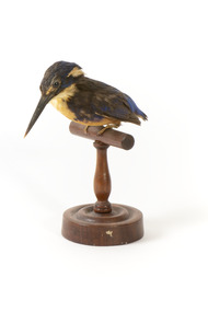
Animal specimen - Azure kingfisher, Trustees of the Australian Museum, 1860-1880
The Azure kingfisher can be located throughout northern and eastern Australia. It can also been found in parts of Indonesia, New Guinea and surrounding islands. This species frequents the Kimberley region in Western Australia and and the Top End of Queensland. In Victoria, it resides inland near the Murray-Darling Basin. These birds prefer to make their homes near bodies of water such as creeks and rivers. They live in areas with shady vegetation. This particular species of Kingfisher are known for their bright and contrasting colouring and tiny stature. They are the smallest kingfisher found in Australia. These birds feed on yabbies and small fish. This specimen is part of a collection of almost 200 animal specimens that were originally acquired as skins from various institutions across Australia, including the Australian Museum in Sydney and the National Museum of Victoria (known as Museums Victoria since 1983), as well as individuals such as amateur anthropologist Reynell Eveleigh Johns between 1860-1880. These skins were then mounted by members of the Burke Museum Committee and put-on display in the formal space of the Museum’s original exhibition hall where they continue to be on display. This display of taxidermy mounts initially served to instruct visitors to the Burke Museum of the natural world around them, today it serves as an insight into the collecting habits of the 19th century.This specimen is part of a significant and rare taxidermy mount collection in the Burke Museum. This collection is scientifically and culturally important for reminding us of how science continues to shape our understanding of the modern world. They demonstrate a capacity to hold evidence of how Australia’s fauna history existed in the past and are potentially important for future environmental research. This collection continues to be on display in the Museum and has become a key part to interpreting the collecting habits of the 19th century.The Azure kingfisher is stylised perched upon a wooden stand and has a paper identification tag attached to one of its legs. This bird has a combination of blue, yellow/orange and black plumage. The orange colour is located upon its chest while the royal blue is upon the rear of the bird on its back and head. The blue has faded in places due to age. The specimen is a diminutive bird species with a wide torso and a long and slender black bill. It has a short tail and two glass black eyes. The feet are a pale cream colour.11a. / Azure Kingfisher See Catalogue, page 9. /taxidermy mount, taxidermy, animalia, burke museum, beechworth, australian museum, skin, reynell eveleigh johns, bird, australian birds, kingfisher, azure, azure kingfisher, small birds, brightly coloured birds -
 Wodonga & District Historical Society Inc
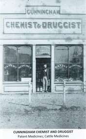
Photograph - J. J. Cunningham, Druggist, c1877
An item in the Ovens and Murray Advertiser of Tuesday 17th December 1872 stated that in the prospect of the good times coming on the completion of the North-Eastern railway, Wodonga was rapidly extending its borders; new buildings are going up in every direction, and business men were flocking there from other parts of the district. One of the most recent arrivals was Mr J. J. Cunningham, late of Growler's Creek. On Saturday 4th January 1873 a notice in The Albury Banner and Wodonga Express informed residents of the Wodonga District that J. J. Cunningham had commenced business as a Chemist and Druggist in Sydney Street, Wodonga. With a carefully selected stock of drugs, patent medicines, horse and cattle medicines, and miscellaneous articles of fancy goods and tobaccos, he promised prompt service and attention to detail. He also provided a service in teeth extraction. It is unsure when John James Cunningham left Wodonga, but in 1896 an action was taken against him in the Supreme Court by Pauline Rennie of Echuca for damages of £500 for negligence and unskilfulness as a chemist and druggist when he had mistakenly given her 10 grains of cocaine instead of a painkilling medication she had requested. The Court gave a finding in her favour but with damages of £75. This item is significant because it captures an early business in Wodonga in the 1870s.A black and white photo of a man standing in the doorway of his business in Wodonga.Above door: CUNNINGHAM / CHEMIST & DRUGGIST On windows: Patent Medicines / Teeth Extracted & Stopped / Cattle Medicinesearly wodonga businesses, j j cunningham chemist and druggist, wodonga 1870s -
 Orbost & District Historical Society
black and white photographs, Jude, Ray, 1915 - 1969
These photographs relate to the East Gippsland Railway. The Bairnsdale-Orbost railway was opened in 1916 to serve the agricultural and timber industry. Because of the decline in traffic and heavy operating costs, the line was finally closed in August, 1987. Orbost Railway Station was opened on Monday 10 April 1916 as the terminus of the Orbost railway line, and closed in 1987. The station was located on the west side of the Snowy River despite the town of Orbost being on the east side of the river, in order to save on the costs of a bridge over the river, which at the time had highly variable levels. These photographs are associated with the history of the Orbost-Bairnsdale railway line and therefore reflects the role that the rail line played in the social and economic history of Orbost.Seven black / white photographs and one postcard print.3103.1 on back - " Orbost- Snowy River flats viaduct 22-2-1964 ARHS special train Ray Jude photo" 3103.2 - on back -" Orbost Snowy River flats viaduct A.R.H.S. special train 22.2.1969" 3103.3 - on back - " A.R.H.S. special across bridge between Waygara & Nowa Nowa 22-2-1964 3103.4 - on back - " Nowa Nowa Boggy Creek Bridge A.R.H.s. Orbost tour Ray Jude photo" 3103.5 - on back - " Orbost 22-2-1969 SM office & goods shed Ray Jude photo" 3103.6 - on back - " Orbost Railway Yards - 22 February 19369 Ray Jude photo" 3103.7 - on back - " Orbost May 27 -1936 Orbost Rail Station" 3103.8 - on front - caption - Unloading Ballast Orbost line near Newmerella 1915 - J. Sullivan Colin ?orbost-railway east-gippsland-railway bairnsdale-orbost-railway -
![Roadway Scene on the Black Spur / [by] Nicholas Caire, circa 1876](/media/collectors/550653872162f11fb04854aa/items/577759b7d0cdd10a5c1a5d0a/item-media/57775a11d0cdd10a5c1aab42/item-fit-380x285.jpg) Kew Historical Society Inc
Kew Historical Society IncPhotograph, Anglo-Australasian Photographic Company, Roadway Scene on the Black Spur, c.1876
Nicholas Caire was born on Guernsey in the Channel Islands in 1837. He arrived in Adelaide with his parents in about 1860. In 1867, following photographic journeys in Gippsland, he opened a studio in Adelaide. From 1870 to 1876 he lived and worked in Talbot in Central Victoria. In 1876 he purchased T. F. Chuck's studios in the Royal Arcade Melbourne. In 1885, following the introduction of dry plate photography, he began a series of landscape series, which were commercially successful. As a photographer, he travelled extensively through Victoria, photographing places few of his contemporaries had previously seen. He died in 1918. Reference: Jack Cato, 'Caire, Nicholas John (1837–1918)', Australian Dictionary of BiographyAn original, rare photograph from the series 'Views of Victoria: General Series' by the photographer, Nicholas Caire (1837-1918). The series of 60 photographs that comprise the series was issued c. 1876 and reinforced a neo-Romantic view of the Australian landscape to which a growing nationalist movement would respond. Nicholas Caire was active as a photographer in Australia from 1858 until his death in 1918. His vision of the Australian bush and pioneer life had a counterpart in the works of Henry Lawson and other nationalist poets, authors and painters.Albumen silver photograph mounted on boardprinted in ink on support l.c.: ROADWAY SCENE ON THE BLACK SPUR. / COPYRIGHT REGISTERED printed in ink (vertically) on support reverse u.c.l.: J.W. FORBES, Agent, printed in ink (vertically) on support reverse c.l.: ANGLO-AUSTRALASIAN PHOTOGRAPHIC COMPANY, MELBOURNE. printed in ink (vertically) on support reverse c.: VIEWS OF VICTORIA. / (GENERAL SERIES.) / No. 18. / ROADWAY SCENE ON THE BLACK SPUR. / The road which is represented in this illustration has lately been constructed by the Government at considerable / expense. It is three miles in length from the base to the summit, some portions of which are very steep. Mails / are conveyed by Cobb & Co.'s Coaches to Marysville and Woodspoint via this route daily. The scenery on the Black / Spur, and beyond as far as Myrtle Creek, is exceedinly picturesque. printed in ink (vertically) on support reverse l.c.l.: 10 Temple Court, Collins Street West.nicholas caire (1837-1918), landscape photography, black spur - victoria -
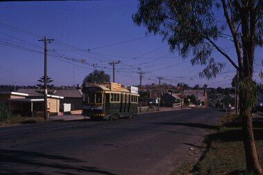 Ballarat Tramway Museum
Slide - 35mm slide/s - set of 25, Noel Simons, 26/02/1972 12:00:00 AM
Set of 25 transparencies taken on 26/2/1972 on Kodak mounts. 1204.1 - Bendigo No. 5 - just arrived at Manchester Loop near Havilah Road, Long Gully. Photo taken after tram has passed photographer. 1204.2 - No. 26 in Backhaus St. Long Gully passing William St, en route to Quarry Hill. Photo taken after tram has passed photographer. 1204.3 - No. 5 climbing the High St. Hill Eaglehawk, heading for Quarry Hill with the buildings on the West side of High St. in the background, including the Eaglehawk Town Hall. 1204.4 - as for 1204.3, but tram close up. 1204.5 - as for 1204.3, but after tram has passed photographer. 1204.6 - No. 5 at intersection of Mt Korong Road Ironbark and Calder Highway, with the AMPOL service 'station in the background. Photo taken after tram has passed photographer. 1204.7 - No. 26 en route to Quarry Hill shortly after leaving Needle Loop, passing William St., Long Gully. 1204.8 - No. 5 at California Gully Loop, picking up a passenger, with the shops at Long Gully in the background. Photo taken after tram has passed photographer. 1204.9 - No. 5 in Long Gully, en route to Quarry Hill. Photo taken after tram has passed photographer. 1204.10 - No. 2 at Eaglehawk terminus with the Eaglehawk Town Hall and Post Office in the background. Tram has two SEC roof ads. 1204.11 - No. 2 at Eaglehawk terminus, close up. 1204.12 - as for 1204.11, but through the park gates. 1204.13 - as for 1204.11, but with tram stop shelters in the foreground and buildings on the West side of High St in the background. 1204.14 - No. 2 in Mt. Korong Rd, midway between California Gully Loop and Needle Loop. Photo taken after tram has passed photographer. 1204.15 - No. 5 in Long Gully, en route to Quarry Hill. 1204.16 - as for 1204.15, but with trams departed loop. Has an ESSO service station in the background. 1204.17 - No. 26 leaves Charing Cross up View St.. Photo taken after tram has passed photographer. Has Armstrong Tyre Service, Cohns Drinks ad on a building and the T&G building in the background. Also Firestone ads on the tyre service building. 1204.18 - No. 5 waits at Charing Cross with the Alexandra Fountain in the background. Tram has two SEC roof ads, 'Everything s fine in my all electric kitchen' and 'Electricity Best for Cooking'. Has RACV, Colonial Mutual Life buildings in the background and the planting areas around Charing Cross gardens in the foreground. 1204.19 - No. 21 en route to North Bendigo arrives at Charing Cross, with passengers waiting to board. No. 5 in the background. In the background is the Fountain Gate Plaza building and the City Family Hotel. 1204.20 - as for 1204.19, but with No. 7 en route to Golden Square. 1204.21 - as for 1204.19, but closer up. 1204.22 - as for 1204.18 1204.23 - No. 25 in Nolan St. near the crossing of Bendigo Creek, running a special tram tour. 1204.24 - No. 25 on a special charter, in Weeroona Ave. at Cnr of Caledonia St. passing the Gas works. 1204.25 - Nos. 25 (showing Golden Square), 7 and 26 at Charing Cross. Has fountain in the background.Information written on in blue ink and date stamped on purple ink. 1204.1 - "No. 5 at Manchester Loop, near Havilah Rd. Long Gully." 1204.2 - "No. 26 in Backhaus St. Long Gully passing William St." 1204.3 - "No. 5 in High St. Eaglehawk." 1204.4 - "No. 5 in High St. Eaglehawk." 1204.5 - "No. 5 in High St. Eaglehawk." 1204.6 - "No. 5 in Mt. Korong Rd., Ironbark, passing Calder Highway Junctn." 1204.7 - "No. 26 shortly after leaving Needle Loop, passing William St., Long Gully. No. 5 cresting hill in distance." 1204.8 - "No. 5 at California Gully Loop." 1204.9 - "No. 5 in Long Gully" 1204.10 - "No. 2 at Eaglehawk terminus." 1204.11 - "No. 2 at Eaglehawk terminus." 1204.12 - "No. 2 at Eaglehawk terminus." 1204.13 - "No. 2 at Eaglehawk terminus." 1204.14 - "No. 2 in Mt. Korong Rd, midway between California Gully Loop and Needle Loop. 1204.15 - "Nos. 2 and 26 crossing at Long Gully." 1204.16 - "No. 26 leaves Long Gully loop for Eaglehawk as No. 2 pulls out of the far end towards Bendigo" 1204.17 - "No. 26 beginning the climb up View St. from Charing Cross." 1204.18 - "No. 5 at Charing Cross." 1204.19 - "No 21 arrives at Charing Cross from Golden Square while No. 5 awaits departure time for Eaglehawk." 1204.20 - "Nos. 7, 21, and 2 (behind which is No. 5) at Charing Cross." 1204.21 - "Nos. 7, 21, and 2 at Charing Cross." 1204.22 - "No. 5 at Charing Cross." 1204.23 - "No. 25 in Nolan St. near Bendigo creek crossing" 1204.24 - "No. 25 in Weeroona Ave. at cnr of Caledonia St." 1204.25 - "Nos. 25, 7, 26 and 2 (behind 26) at Charing Cross."tramways, trams, bendigo, eaglehawk, long gully, california gully, charing cross, north bendigo, tram 2, tram 5, tram 7, tram 21, tram 25, tram 26 -
 Eltham District Historical Society Inc
Photograph - Digital Photograph, Marguerite Marshall, Eltham Lower Park, 20 April 2008
Originally a race course, the park has brought the community together with a variety of activities. Published: Nillumbik Now and Then / Marguerite Marshall 2008; photographs Alan King with Marguerite Marshall.; p45 Once used for horse racing, which attracted visitors from Melbourne, the Eltham Lower Park has brought the community together with a wide range of activities. Horse riding is now enjoyed as a recreation in the park as are other sports. The park also includes the Diamond Valley Railway miniature trains and a sanctuary for the rare and vulnerable Eltham Copper Butterfly. Eltham Lower Park, with other parks, forms an almost continuous green band from Eltham’s centre, along the Diamond Creek to the Yarra River.1 Before European settlement the Wurundjeri people met on this land, particularly at the junction of the Diamond Creek with the Yarra River, which they called Birr-arung. This is commemorated by the sculpture, Not just a Pretty Place by Aleks Danko, winner of the 2000 Nillumbik Art in Public Places Award. The first European to settle here was probably Henry Foley, who in 1841 used it as part of his pastoral run. Foley sold his leasehold to Joseph Wilson in 1845, who soon after sold it to Frederick Falkiner. During the 1840s the future park was part of a government square mile (2.6 sqkm) reserve, north of the Yarra, within the Parish of Nillumbik, later named Eltham. Soon the land was used for horse racing after nearby residents cleared ten acres (4ha) in the early 1850s. A three-quarter of a mile (1.2km) race secured the winner the £10 Publican’s Prize. In response to popular demand, the newly formed Eltham District Road Board petitioned the Surveyor General of the Colony of Victoria, in 1856, for 36 acres (14.6ha) of crown land for a racecourse and recreation. By 1858 the Eltham races had become an institution. ‘Many skirmishes occurred and the way home was paved with temptation, with sly-grog for sale.3 In the early 1870s, two jockeys were sons of the police officer in charge of the Eltham Police Station, Miles S Lyons. Another ten acres (4ha) was added to the area in 1866 and 12 acres (4.8ha) – Hohnes Hill – in 1870. In 1866, two acres (0.8ha) on the creek banks became an animal pound with William Walsh the pound keeper in 1870, but this was later incorporated into the park. By 1877 the area was called a public park but horse racing and training continued into the 1920s. In the mid-1900s trotters were trained on a circuit road. In 1953 the Eltham Pony Club was established and used a cross-country course on Hohnes Hill. From the mid 1950s the club held the Eltham Easter Fair at the park, later to include a procession along Main Road from the town centre to the park. The park also attracted picnic parties and campers from the inner suburbs as did Wingrove Park, and businesses catering for visitors, sprang up on the opposite side of Main Road. Bus-loads of school children visited the park for Gould League bird days in the 1960s. In 1979 the Eltham Shire Council bought Lenister Farm, linking the park with the Yarra River. The Lenister Farm wetland includes a bird hide, viewing platform and interpretive signs.5 Pioneer Henry Stooke, later Road Board chairman, bought the 11 acres (4.5ha) - later to become Lenister Farm - from the Crown in 1862. Stooke never lived on this site and the two houses at Lenister Farm were built in the 20th century. Since its formation in 1871, the Council has controlled this crown land, which it named Eltham Park. But in the 1920s Eltham Council bought land near the town centre for a park, which it named Eltham Central Park. To avoid confusion the Council renamed Eltham Park, Eltham Lower Park. Since 2004 the Yarra footbridge has linked the park with the Yarra Valley Metropolitan Park and the Main Yarra Trail.This collection of almost 130 photos about places and people within the Shire of Nillumbik, an urban and rural municipality in Melbourne's north, contributes to an understanding of the history of the Shire. Published in 2008 immediately prior to the Black Saturday bushfires of February 7, 2009, it documents sites that were impacted, and in some cases destroyed by the fires. It includes photographs taken especially for the publication, creating a unique time capsule representing the Shire in the early 21st century. It remains the most recent comprehenesive publication devoted to the Shire's history connecting local residents to the past. nillumbik now and then (marshall-king) collection, eltham lower park, eltham park -
 Eltham District Historical Society Inc
Photograph - Digital Photograph, Marguerite Marshall, Eltham Retirement Centre (Judge Book Memorial Village), Diamond Street, Eltham, 23 October 2006
Thousands of elderly people at this centre have contributed much. Published: Nillumbik Now and Then / Marguerite Marshall 2008; photographs Alan King with Marguerite Marshall.; p161 Thousands of elderly people, who have contributed much to Nillumbik and beyond, have made their home in the treed Eltham Retirement Centre. The centre, which opened in 1956, has housed the disadvantaged in particular, through good times and hard, including floods, fire and even burglaries. As part of the Melbourne Citymission, a non-denominational Christian organisation that cares for people living with disadvantage, the centre was built to celebrate 100 years of the Melbourne Citymission’s work since 1854. Standing on a former poultry farm called Willandra (Still Waters), the centre includes independent units, hostel, nursing home accommodation and a Day Therapy Centre, which is available for non-residents as well. Despite being metres from the busy Main Road and railway station, the centre provides a quiet oasis on 6.8 hectares bordered by the Diamond Creek to the west, and the railway line to the east. The centre was originally named Judge Book Memorial Village after Judge Clifford Book, Deacon of the Collins Street Baptist Church. Book was also President of the Baptist Union of Victoria and Grand Master of the Masonic Lodge. He was so respected that, at his death, several Pentridge prisoners asked to attend his funeral. In 1993 the centre’s name was changed to clarify that it was part of the Melbourne Citymission. However Judge Book’s name continues in the Judge Book Memorial Garden, opened in 2006. The Diamond Creek has flooded the centre several times, however rarely causing serious damage. Volunteer Alan Field recalls a flood in 1974 when the resident manager Reverend Norman Pearce and his wife, were rescued by boat from their home with their budgerigar. On February 3, 2005, when the creek almost flooded Metzner Hall, 35 ambulances evacuated residents to nearby nursing homes, hostels and local homes. Residents were also evacuated during the 1965 bush fire, but fortunately a change of wind direction saved the centre. Residents have also endured several burglaries. Despite much rebuilding and modernisation over the years, traces of the original farmhouse remain in the administration areas. In 1991 the Willandra Hostel was built and in 2001 the Eltham Lodge Nursing Home with each room having a garden view. Several buildings are named after people who have given special service to the centre including the Norman Pearce Day Hospital after general manager and pastor Rev Pearce. Metzner Hall was named after the Metzner family who had been active in the auxiliary since it began and had donated generously to the Recreation Hall fund.3 A bridge was named after Sister Lila Murray who had worked at the village for 42 years in various capacities including as relieving manager. Field remembers Sister Murray as ‘the Mother Teresa and soul of what the village aspired to, with love and care’. Since 1957 the Eltham Auxiliary, later called the Residents’ Association, has worked to improve the residents’ quality of life by volunteering and raising funds. An outstanding volunteer, Field, who was drawn to the centre in 1971 with his wife Chris, has held positions on the early Eltham boards, auxiliaries and Residents’ Association. Much of his work has been supporting people with no family and those of limited means. He says he and his wife look at their work as having shared ‘our lives with amazing people’. The wealth of experience and wisdom in the Retirement Village has benefited many people, including local school children. Residents have acted as proxy grand-parents at local schools, by assisting small learning groups or telling their life stories. Conversely, students from local schools have visited to perform, or to assist in programs like craft activities. Resident Val Bell, whose mother Rose Bullock lived at the centre before her, sums up the centre’s most important attribute for her: ‘The Christian care. They could not be more caring’.This collection of almost 130 photos about places and people within the Shire of Nillumbik, an urban and rural municipality in Melbourne's north, contributes to an understanding of the history of the Shire. Published in 2008 immediately prior to the Black Saturday bushfires of February 7, 2009, it documents sites that were impacted, and in some cases destroyed by the fires. It includes photographs taken especially for the publication, creating a unique time capsule representing the Shire in the early 21st century. It remains the most recent comprehenesive publication devoted to the Shire's history connecting local residents to the past. nillumbik now and then (marshall-king) collection, diamond street, eltham, eltham retirement centre, eltham retirement village, judge book memorial village -
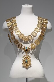 Bayside Gallery - Bayside City Council Art & Heritage Collection
Ceremonial object - Mayoral chain, Blashki, City of Sandringham Mayoral Chain, c. 1954
This chain was part of the official regalia worn by the Mayor of the City of Sandringham before the amalgamation into Bayside City Council in 1994. The chain was seen as an outward sign of power, authority, and responsibility and was a formal, full-dress type of regalia that was worn by the mayor over their robes at ceremonial functions. The large central drop medallion features the design of the council sea, and the links of the chains are made of cutwork initials of each Mayor. The Sandringham seal was designed by Sans and McDougal had been selected in 1917, by a special committee and its main features are the Sandringham pier and breakwater, with a yacht in full sail as an inset, supported by two dolphins. The motto reads 'Omni Opere' which translates to ‘With all earnestness.’9 carat yellow gold mayoral chain for the City of Sandringham. Consists of two concentric circles of 57 small oval links, with an Australian Coat of Arms as a centrepiece and a large 'drop' medallion of the City of Sandringham seal below. Each oval link is made up of the cutwork initials of a mayor, the surrounding oval border has an inscription above the initials which gives the mayor's name; an inscription below gives dates of office; the earliest is Cr. B.J. Ferdinando 1917-18, and latest is Cr. S.T. Russell 1993-94. The ovals are surrounded by decorative scrolls and are joined by small curb chains. The outer circle contains 31 links, while the inner contains 26. On both shoulders sit decorative bars, joining the front of the chain to the back. The main medallion has an oval central panel that features the coloured Sandringham seal in enamel depicting two sailboats in the water, a pier protruding from the left, a coastline on the right with two pine trees. Above the scene are decorative triangles in light blue and yellow, above which is another section in dark blue containing a third sailboat. The seal is flanked by two engraved dolphins and above it sits an engraved St Edward's gold crown filled with red enamel. Below the seal, there is a ribbon containing the Latin motto 'OMNI OPERE' which is engraved and filled in dark blue enamel. The pendant is surrounded by cutwork lettering reading 'CITY OF SANDRINGHAM / 1919' and leaf decorations. The medallion is inscribed on the reverse with important dates in Sandringham's history. A fleur-de-lys joins the medallion to the Australian Coat of Arms centrepiece above. The Coat of Arms features a shield, depicting symbols of Australia's six states, in enamel, flanked by an engraved kangaroo on the left and emu on the right. Below it sits a ribbon engraved 'ADVANCE AUSTRALIA'.mayoral chain, ceremonial wear, seal, medallion, mayor, coat of arms, crest, bayside, blashki & sons, city of sandringham, sandringham, omni opere, blashki, mayoral regalia, motto, st edward's crown, sans and mcdougall -
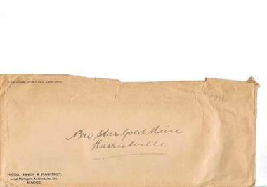 Bendigo Historical Society Inc.
Document - MCCOLL, RANKIN AND STANISTREET COLLECTION: NEW STAR GOLD MINE HARRIETVILLE NL, c1934
McColl Rankin & Stanistreet, New Star Gold Mine Harrietville NL. a/ Department of Mines 20.2.1934 laboratory reports results, 3 receipts attached, list of general expenses, quarter ended 30.4.1934, heading Dargo ''Gold Butterfly'' Gold Butterfly crossed out hand inscription Gold Reefs Syndicate, Wanangatta, Dargo. b/ copy of Purchase agreement of leasehold land for the purpose of mining. Dated 28.6.1934. c/ Payments by R.A. Rankin - Office Account A/C Leases No's. 5187 and 5195 Dargo, Gippsland, prior to exercise of option. Inscription: Paid by New Star Company ?? On ?? 1934 ?? ?? ??. d/ Letter: purchase of Leases No's 5187 & 5195 Black Snake Black Snake Creek, Dargo. Dated: 22.8.1934. e/ letter acknowledging receipt of payment for application of Lease No. 5187, lease will be delayed until precise area is determined. Signed: ?? Rankin. 3 pence stamp for stamp duty attached. Dated: 23.8.1934. f/ Memo, Mr Grelis. Re Leases No's 5187 & 5195 Dated: 4.9.1935. Signed: ?? g/ McColl Rankin & Stanistreet business envelope. Envelope labelled New Star Gold Mine Harrietville. 46.organization, business, gold mine, mccoll rankin & stanistreet, new star gold mine harrietville nl. dargo ''gold butterfly'' gold reefs syndicate, wanangatta, dargo black snake black snake creek 1934 1935 -
 Southern Sherbrooke Historical Society Inc.
Typescript|Photograph - copy
Single page typescript composed by Jill A'Vard, and single page with four copies of photographs. -Micawber Park Picnic Ground Belgrave c. 1934 shows a forest scene, a creek with a large tree fallen across it, a wooden footbridge, and a man in a hat standing on the bridge. Black and white photo. -Micawber Tea Rooms Belgrave shows a group of two men and two women standing on the verandah of a building which bears the signs "Refreshments", "Hot water" and "Micawber Tea Rooms". Black and white photo. -Ted & Lil A'Vard sitting in their lounge room at Micawber Park c. 1935 shows a middle-aged couple in armchairs in front of a brick fireplace. The mantelpiece holds several items including a clock. Behind the woman, on the right side, is a wooden stand with a green vase holding an arrangement of autumn-coloured flowers and foliage. The man is holding a book and there is possibly a dark dog at the woman's feet. Black and white photo which has been coloured in the top right corner (flower vase and edge of mantelpiece). -Alf & Maggie A'Vard's "The Valley" is a Rose Series postcard P. 1488, showing a house in a forest setting with a group of people on the verandah.albert a'vard, a'vard family, micawber park, alf a'vard, the valley -
Bendigo Historical Society Inc.
Document - AUCTION SALES - MINING CATALOGUE AUCTION SALES
BHS CollectionYellow and white patterned, spring back Spirax Students No. 594 Note Book containing extracts from mining Catalogues loaned by Mr. Dyett (J. H. Curnow's). Mines mentioned include Ramrod Gold Mine, Hercules No. 1, Central Blue, South Virginia Extended, Alfords Battery, South New Moon,The Gold Mine Clunes, Guildford Plateau, Big Blue, Spring Gully Mine at Chewton, Eureka Central at Chewton, Bdgo Amalg. Goldfields Limited, Koch's Air Station, Cornish Mine, Carlisle Battery, Victory & Pandora Mine, Garden Gully, Londonderry Mine, Princess Dagmar, Golden Age, Suffolk United, Virginia South Extended, South Red White & Blue, Pitfield Plains Glenfine South Shaft, Adelong Dredge & Leases, Bright Valley Dredge, North Chewton (Chewton), Talbot Alluvials Norbury's No. 2 Shaft, Gordon Gold Mine Inglewood, Post Office Hill Mine Chewton, Carlisle & Whittaker Plant Maldon, Bunninyong, Yandoit Mine, North Chewton, Golden Transverse Bdgo, Yandoit Co., Chapman's Gold Mine Chewton, Ross Creek Extended G. M. Coy (Ballarat).book, bendigo, mining auction sales, auction sales mining catalogue auction sales, j h curnow, mr dyett, a richardson, ramrod gold mine, hercules no. 1, central blue, south virginia extended, alfords battery, south new moon, the gold mine clunes, guildford plateau, big blue, spring gully mine at chewton, eureka central at chewton, bdgo amalg. goldfields limited, koch's air station, cornish mine, carlisle battery, victory & pandora mine, garden gully, londonderry mine, princess dagmar, golden age, suffolk united, virginia south extended, south red white & blue, pitfield plains glenfine south shaft, adelong dredge & leases, bright valley dredge, north chewton (chewton), talbot alluvials norbury's no. 2 shaft, gordon gold mine inglewood, post office hill mine chewton, carlisle & whittaker plant maldon, bunninyong, yandoit mine, north chewton, golden transverse bdgo, yandoit co., chapman's gold mine chewton, ross creek extended g. m. coy (ballarat). -
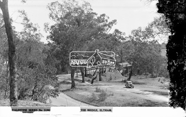 Eltham District Historical Society Inc
Negative - Photograph, The Rose Stereograph Company, The Bridge, Eltham, c.1939
Looking west across the Main Road Bridge over the Diamond Creek at Eltham, c.1939. The car in the foreground, possibly the photographer's, is a Ford Model C Ten built by Ford UK between 1934 and 1937. The Model C was released in Australia in 1935. The Ford Model C Ten is a car that was built by Ford UK between 1934 and 1937. The Model C was released in Australia in 1935 https://en.wikipedia.org/wiki/Ford_Model_C_Ten This glass plate negative was used to manufacture postcards (1:1 printing) for commercial sale by the Rose Sterograph Company and its subsidiaries. George Rose founded the Rose Stereograph Company in 1880 and was joined by Herbert (Bert) Cutts in the early 20th Century. The pair formed a lifetime working partnership and strong personal friendship. Assisted by George’s two sons, Herbert George and Walter, and later by Neil Cutts, the Rose Stereograph Company continued its operations for more than 140 years. The company was initially built on stereographs, but as cinema took over and stereographs fell out of fashion, the Rose Stereograph Company developed Australia’s first commercially viable photographic postcard business. Specialising in postcards of iconic historical moments and significant landmarks, The Rose Stereograph Company became a staple of the Australian travel industry.This remarkable collection of glass plate negatives, transparencies, and postcards – arguably Australia’s most significant photography collection outside of public hands – has been passed down through the generations, surviving war, relocation, and the harsh Victorian climate. The historic Rose Stereograph collection is the culmination of George Rose’s dream of capturing and preserving precious moments in time and remains the legacy of the Rose and Cutts families. It is with great sadness that the Cutts family says goodbye to a collection that spans five generations and 140 years. The Cutts family understands that for these historically important pieces to rest with one family is to deny others the pleasure of their custodianship.Glass Plate Negative Size: 9 x 13.9 cmThe Bridge, Eltham, Valentine Series No. 3196, Copyrightpeter and elizabeth pidgeon collection, bridge, cars, diamond creek (creek), eltham, eltham south, ford model c ten, glass plate negative, main road, main road bridge, motor vehicles, postcard, rose stereograph, rose stereograph company, valentine series postcard