Showing 8151 items matching "working"
-
 Orbost & District Historical Society
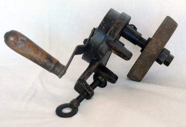
grinder, late 19th -early 20th century
A hand operated knife/blade sharpener was a very important implement for farmers to keep tools in good working condition. A hand-operated grinding and blade sharpening wheel. It has a wooden handle, stone wheel and a clamp for attachment to a flat surface. grinder knife-sharpener -
 Orbost & District Historical Society
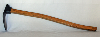
adze, late 19th century
Adzes are used for smoothing or carving wood in hand woodworking. It is similar to an axe but with the cutting edge perpendicular to the handle. It is used chiefly for shaping wood.A square ended adze that has a thin arched blade set at right angles to the wooden handle. The handle is not original.wood-working-tool adze carpentry -
 Orbost & District Historical Society
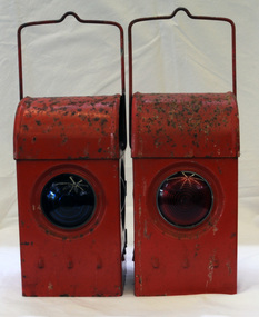
signal lamps
Possibly used in the Orbost district. Railway lamps of this kind were hand signalling lamps used by train guards, shunters and sometimes signalmen and station staff. They could signal the locomotive crew at night to let them know what to do (move forward/move backward/right-of-way) when leaving a station, goods yard or siding. Railway lamps of this kind were significant railway items in their period of use as essential tools to the safe-working operations of the railway. Two railway signal lamps. These are kerosene burning lamps made of metal and painted red. Both lamps have carrying handles at the top. .1 has a green glass lens and .2 has a red glass lens. signals lamps communication railway transport kerosene-burning -
 Orbost & District Historical Society
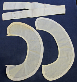
collars
Miss Ethel Lynn nursed in England for a time in her later life. She did private nursing at Orbost Hospital until she had a fall and broke her hip -1950's.The Lynn family is well-known in the Orbost area. Ethel Lynn is believed to have been working at Bairnsdale in 1924. Two white linen collars to be worn on a nurse's uniform. A white linen belt to be worn with a nurse's uniform.E. LYNNnursing health lynn-ethel uniform-nursing -
 The Beechworth Burke Museum
Photograph - Photograph - Reproduction
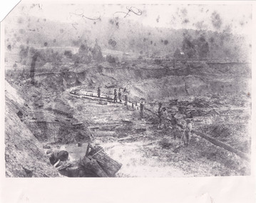
This photograph depicts mining operations within the Beechworth area, in an unidentified valley where sluicing was utilised as a method for extracting gold from the environment. After gold was discovered in the region in 1851, sluicing became a characteristic of gold mining in the region - "Ovens miners carved intricate networks of races" throughout the region - involved the diversion of water in many channels, or water races, which contained inbuilt 'ripple devices' designed to trap gold for later extraction. By 1871, 900 miles of water races had been cut into the Beechworth Mining District. As suggested by the numerous figures involved in labouring along the water race, sluicing was a source of considerable employment within the region. This image is of important historical significance for its ability to convey information about sluicing and the methods used to find gold in the 1850s, and provides clues as to how sluicing and the widespread construction of water ranges changed the environment of the region. This image is important for current research into the history of the Ovens region in Victoria, which played such a prominent role in the early Australian gold mining industry. Therefore, this image has the capacity to be beneficial for research into society and the motivations of those living and working in this region during this period and therefore, has social significance. The Beechworth Burke Museum has additional images relating to gold sluicing and and the mining activities in the area more generally, which can be analysed and studied alongside images like this one.A black and white rectangular photograph printed on matte photographic paperbeechworth, mining, miners, labour, water race, sluicing -
 The Beechworth Burke Museum
Photograph - Photograph - Reproduction
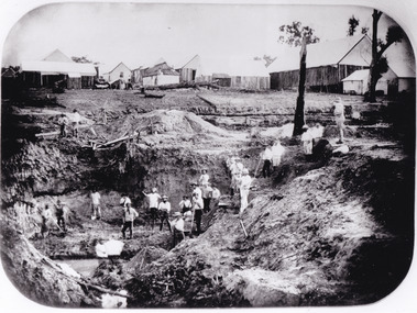
After gold was discovered to be deposited "for miles along Woolshed Valley" in the early 1850s, the Woolshed became a major site of mining activity in the north-east . This region was divided into large claims of 80 yards long, one of which was the one depicted in this photograph, called 'Big Johnson's Claim'. Claims such as this utilised a range of technology, including water wheels, steam engines, sluices and toms, most of which would not arrive until after 1856 when this photograph was taken. The Woolshed initially became prosperous in 1855, and labourers, such as the ones depicted in this photograph, engaged in sinking work for 7 pounds a week, whilst other mining labourers could earn up to nine. The search for gold is ingrained into the history of Victoria and therefore, images like this one which portray an open cut sluicing site can reveal important information for society and technology for the date when the photograph was taken. This image is of important historical significance for its ability to convey information about the operations of mining claims, particularly of the Woolshed Valley area that this photograph documents. This image is important for current research into the history of Woolshed, which was a major site of mining significance and operations. Therefore, this image has the capacity to be beneficial for research into society and the motivations of those living and working in this region during this period and therefore, has social significance. The Beechworth Burke Museum has additional images relating to gold sluicing and the Woolshed area which can be analysed and studied alongside images like this one. A black and white rectangular photograph printed on matte photographic paper.Reverse: 7791 / page 34. / 52% / Big Johnstone / Claim on Woolshed Goldfields / 1856 / Note canvas [illegible] building / Burke Museum /woolshed, mining, claims, mining claims, big johnson, gold -
 The Beechworth Burke Museum
Postcard, c1900-1912
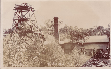
This object is a photographic postcard showing some of the above-ground structures of the Golden Bar mine in Chiltern, including a building with a smokestack and the poppet head which is used to haul equipment, materials, and men above or below ground. The Golden Bar site, mined by the Golden Bar Mining Company which was formed in 1901, managed to yield approximately 12,453 oz of gold before work stopped in 1912 - it was one of the principal mines in the area, as well as the deepest and one of the richest. The text on the postcard was handwritten by H.Gordon (?) to Issy (?), to show the mine where he presumably worked as he promises to take them 'above and below'. The postcard can be approximately dated to between 1901-1912. It is stated that after 1902 Kodak added the line on the postcard backs to divide into correspondence and address sections as seen on the reverse of this object. In addition, there is also a similar Kodak photographic postcard in the Burke Museum collection that is dated to 1908 and has the same specific font type and manufacturer markings (see references for link). Lastly, the Golden Bar mine ceased operations in 1912 so the photograph was likely taken prior to this. This photographic postcard is a rare and fair conditioned representation of one of the most significant gold mines in the Chiltern area, showing the above ground structures at the time it was being actively mined. This postcard also holds social significance as a snapshot of working life in the gold mining rush of Victoria, and a personal record of one of its miners. A sepia rectangular postcard printed on card.Obverse: Dudley Studio / Golden Bar. Chiltern Reverse: BMM 8034 / Post Card. / Correspondence. / Address Only. / Kodak. Austral. 110 / My Dear Issy (?), / A card only, to show (?) the mine / and when you come down I will / take you above and below, / All (...) love, me to. Has the baby / gone home yet Heini (?) wants to know / give my love to Syd when next you write / Your loving (...), H. Gordon (?)photographic postcard, postcard, chiltern, golden bar mine, golden bar mining company, dudley studio, kodak -
 The Beechworth Burke Museum
Photograph, unknown
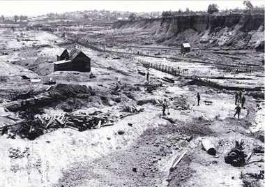
This reproduced photograph is of Pennyweight Flat near Beechworth, a notable area of the 1850's gold rush in Victoria. Donald Fletcher, migrating to Beechworth from Scotland in 1855, had substantial claims at Pennyweight Flat and was amongst the first in the district to utilise hydraulic sluicing and water diverting methods.The flat is said to have seen a flurry of 200 miners to the area around 1857, and by 1861 when work commenced on extending Fletcher's tail race the census recorded 644 people residing there (European males, females and Chinese). Pennyweight Flat is also significant for the cemetery that resides on the hilltop and which noted approximately 200 burials from the gold rush period 1852-1857, known for a long period as a children's cemetery due to the number of children's graves present.The search for gold is ingrained into the history of Victoria and therefore, images like this one which portray an open cut sluicing site can reveal important information for society and technology for the date when the photograph was taken. This image is of important historical significance for its ability to convey information about sluicing and the methods used to find gold in 1910. It also shows a location where sluicing was undertaken which provides insight into the impact of sluicing on the environment at a time when it was done. This image is important for current research into the history of Beechworth and surrounding area including Victoria's North East. The Rocky Mountain Extended Gold Sluicing Company was a long running and very active mine that was one of the most successful and largest in the district. Therefore, this image has the capacity to be beneficial for research into society and the motivations of those living and working in this region during this period and therefore, has social significance. The Beechworth Burke Museum has additional images relating to gold sluicing which can be analysed and studied alongside images like this one. When the mine closed in 1921, in a liquidation sale, Zwar purchased the tunnel and clear water supply that ran under the town of Beechworth. He directed the water to his tannery and over time built a major industry in leather works that was a major employer in Beechworth. In growing his leather business, Zwar installed crude oil engines for electricity in his factory. He oversaw working with local council to introduce electricity to Beechworth via a sub-station on Albert Street. In 1927 Electric street lamps replaced gas lamps in the streets of Beechworth. Black and white rectangular reproduced photograph printed on glossy photographic paperObverse: Reverse: 84.222.5/ digital print/ rocky mountain extended gold sluicing company, gold, sluicing, gold sluicing, hydraulic sluicing, gold mine, open cut mining, mining, gold mining, north-east victoria, beechworth, burke museum -
 The Beechworth Burke Museum
Photograph
This photograph depicts four men standing near a large unidentified building. This building is the entrance to a deep lead mine shaft. There is a bridge entering the building, which was used to access the elevator to the shaft. Deep lead mining involved placing large shafts into the ground which miners use to access deeper locations in order to excavate the rocks in the search for lead. Deep lead mining was highly dangerous as roofs could cave in of the soil was loose. Therefore, this particular mining considered to be highly undesirable profession as many miners did not want to work long hours nor risk their lives in the search for lead. Indigo Shire was a large area where deep lead mining took place, and thus the landscape and environment was largely impacted by these mining businesses. The Indigo Shire grew in population and wealth in the early 1850s when people came into this location in the hopes of finding gold and making a fortune. Ultimately, the accessibility and availability of gold and precious metals decreased once the gold reserves dried up and alongside this, the large population moved away. The Ovens was also heavily impacted environmentally as deep mining resulted in the change in land formation.The search for gold is ingrained into the history of Victoria and therefore, images like this one which portray an open cut sluicing site can reveal important information for society and technology for the date when the photograph was taken. This image is of important historical significance for its ability to convey information about the methods used to find gold in Indigo Shire. It also shows a location where deep mining was undertook which provides insight into the impact of deep mining on the environment at a time when it was done. This image is important for current research into the history of Indigo Shire, a region in Victoria's north-east. Therefore, this image has the capacity to be beneficial for research into society and the motivations of those living and working in this region during this period and therefore, has social significance. The Beechworth Burke Museum has additional images relating to deep lead mining and Indigo Shire which can be analysed and studied alongside images like this one.Sepia coloured retangular photo printed on gloss photographic paper.Reverse: 1997, 2510/ A02570/ Deep Lead Mining/ page 94/ 65%/ Burke Museum, Photo 44beechworth, burke museum, indigo shire, deep lead mining, mining, gold, gold mining -
 The Beechworth Burke Museum
Photograph
This photograph dating between the 1850s and early 1900s depicts an open cut sluicing site located in Allan's Flat looking upon the open cut from Staghorn Flat Number 1. Sluicing was undertaken in the area from 1850 to 1904. The image depicts a location mined by Yackandandah Sluicing Co. It portrays and open space with pipes laying on the ground and connected to pipes leaving the barge. These pipes were used to wash and seperate the qaurtz. There are two small buildings on high ground over looking the barge. Yackandandah Sluicing Co. was created by J.A. Wallace in the 1880s. The Yackandandah Sluicing Co. operated from the mid-1880s to the early 1900s, when resources eventually ran out. Open cut sluicing involved the use of high-powered hoses which used the centrifugal sand pump system (known as hydraulic sluicing) which broke down the soil which was then processed for quartz, gold and other materials. After the resources where drained, Wallace reaped the benefits of his mining business. Allan's Flat is located on the Yackandandah Creek, and is 10km north-east of Yackandandah and 20km south of Wodonga in Victoria's regional north-east. Allan's Flat was initially used to mine gold through alluvial methods, however that came to an end with little results. The mining business was then revived by J.A. Wallace with the introduction of hydraulic sluicing.The search for gold is ingrained into the history of Victoria and therefore, images like this one which portray an open cut sluicing site can reveal important information for society and technology for the date when the photograph was taken. This image is of important historical significance for its ability to convey information about sluicing and the methods used to find gold and other minerals in the lat 19th Century. It also shows a location where sluicing was undertook which provides insight into the impact of sluicing on the environment at a time when it was done. This image is important for current research into the history of Allan's Flat, a small regional location near Yackandandah in Victoria's North East. Therefore, this image has the capacity to be beneficial for research into society and the motivations of those living and working in this region during this period and therefore, has social significance. The Beechworth Burke Museum has additional images relating to gold sluicing and Allan's Flat which can be analysed and studied alongside images like this one.Sepia coloured retangular photograph printed on gloss photographic paper mounted on board.Revers: Sluicing at Allan's Fortallan's flat, north east gold, sluicing, gold sluicing, hydraulic sluicing, mining, gold and quartz mine, beechworth, burke museum, yackandandah -
 The Beechworth Burke Museum
Photograph, Late 1900s
This photograph dating to the late 1900s depicts the entrance to a reef mine the in Beechworth division. The image depicts two men outside the entrance, which is covered by a hut, where one is standing near a mine cart. The mine car was used to haul soil from the mine. The Beewchworth divison consisted of 5 locations: Beechworth, Stanley, El Dorado, Hurdle Flat and Stony Creek. These locations were set up due to speculative fever that more gold could be found. In places such as El Dorado, Beechworth and Stanley there was profit, however Hurdle Flat and Stonry Creek, gold could not be found in the quantities that was required. By 1880 the Beechworth division was in depression due to the reserves being used up. However, in spite of the depression mining was continued until the late 20th Century.The search for gold is ingrained into the history of Victoria and therefore, images like this one which portray an open cut sluicing site can reveal important information for society and technology for the date when the photograph was taken. This image is of important historical significance for its ability to convey information about reef mining in the late 1900s. It also shows a location where reef mining was undertook which provides insight into the impact of reef mining on the environment at a time when it was done. This image is important for current research into the history of Beechworth , a town in Victoria's north-east. Therefore, this image has the capacity to be beneficial for research into society and the motivations of those living and working in this region during this period and therefore, has social significance. The Beechworth Burke Museum has additional images relating to reef mining and Beechworth which can be analysed and studied alongside images like this one.Sepia coloured retangular photograph printed on newspaper.Reverse: 7813beechworth, beechworth division, mining, reef mining, gold, gold mining, 1990 -
 The Beechworth Burke Museum
Photograph, 1907-8
The photo from 1907-8 is a sepia print, depicting a small valley with building at base. There are flumes visible above areas of water, trees on hills and a few small cottages on the hillside. Cock's Pioneer Gold & Tin Sluicing Co NZ No 2 Site. The photo was taken of Matthews Gully looking west. Sluicing was undertaken in the area from 1900 to 1942 with some short breaks between these periods. The image depicts a location mined by Cocks Pioneer Gold and Tin Sluicing Company (as recorded on the annotation on the card mount) The Cocks Pioneer Gold and Tin Mines N.L was one of El Dorado's two largest open cut sluicing mines of the 20th Century. The other was named the Cocks El Dorado Gold Dredging Company. The Cocks Pioneer Mines operated from 1901 until 1941 and found a total of 117,378 ounces of Gold and 1,673 tones of tin concentrates over these years. The Cocks company was formed in 1898 and operated until 1941. Open cut sluicing involved the use of high-powered hoses which used the centrifugal sand pump system (known as hydraulic sluicing) which broke down the soil which was then processed for gold and other precious metals. From 1914 , four years after this image was captured, the company reformed to Cocks Pioneer Gold and Tin Mines NL (previously it was known as Cocks Pioneer Sluicing Co) and undertook large scale sluicing operations until 1929 and then 1934-1941. El Dorado is located on Reedy Creek and is surrounded by forested country to the north and east. It is 20 km east of Wangaratta in Victoria's regional north-east. John Cock was the son of a Cornish minor who arrived in El Dorado in 1858. Cock founded his gold and tin mining company which ran successfully for many years in the El Dorado region. It was an open cut sluicing company because of the abandonment of underground mining after this was deemed too dangerous. In 1935 Cock's El Dorado Company commissioned the floating dredge which is still visible in El Dorado today. The dredge was built by the Thompson engineering works, Castlemaine, and weighed over 2,000 tones and today has a place on the Victorian Registers of historic buildings. Interestingly, the name El Dorado does not derive from the gold in the region, but from the Barambogie pastoral run completed by William Baker in 1840-1841. Gold was discovered in El Dorado 1854 but the gold was too deep for individual prospectors to find, it required the use of heavy machinery.The search for gold is ingrained into the history of Victoria and therefore, images like this one which portray an open cut sluicing site can reveal important information for society and technology for the date when the photograph was taken. This image is of important historical significance for its ability to convey information about sluicing and the methods used to find gold in 1910. It also shows a location where sluicing was undertook which provides insight into the impact of sluicing on the environment at a time when it was done. This image is important for current research into the history of El Dorado, a small regional location near Wangaratta in Victoria's North East. Therefore, this image has the capacity to be beneficial for research into society and the motivations of those living and working in this region during this period and therefore, has social significance. The Beechworth Burke Museum has additional images relating to gold sluicing and El Dorado which can be analysed and studied alongside images like this one.Sepia coloured rectangle photograph printed on gloss photographic paper Reverse: 1997. 2613/ A02613/ No2 site/ Matthews Gully/ Cocks Pioneer G&T. ?? Co NZ/ No2 Site looking West/ 1907-8/ (7)sluicing, hydraulic sluicing, 1907, 1908, mining, cock's pioneer gold & tin sluicing co nz, nz, site no 2, matthews gully, west, valley, building, cottages, hillside, trees, water, gold and tin mine -
 The Beechworth Burke Museum
Photograph, 1910 - 1911
This photograph depicts Cock's Pioneer G & T Sluicing site No. 4 in El Dorado. Looking eastwards, the photo captures a wooden and tin building with various mining equipment strewn in the foreground. Underneath the verandah, figures can be seen. These are believed to be a Mr. Hollister (left), Mrs. Breustedt (4th from left), children Min and Chris Breustedt, and Kate Timmons holding a girl's hand. The Cocks Pioneer Gold and Tin Mines N.L was one of El Dorado's two largest open-cut sluicing mines of the 20th Century. The other was named the Cocks El Dorado Gold Dredging Company. The Cocks Pioneer Mines operated from 1901 until 1941 and found a total of 117,378 ounces of Gold and 1,673 tones of tin concentrates over these years. The Cocks company was formed in 1898 and operated until 1941. Open cut sluicing involved the use of high-powered hoses which used the centrifugal sand pump system (known as hydraulic sluicing) which broke down the soil which was then processed for gold and other precious metals. From 1914, four years after this image was captured, the company reformed to Cocks Pioneer Gold and Tin Mines NL (previously it was known as Cocks Pioneer Sluicing Co) and undertook large-scale sluicing operations until 1929 and then 1934-1941. The Cocks Pioneer was an extremely successful mining company during the 20th century. In the Annual Report of the Secretary for Mines for the year 1915, the Cocks Pioneer was the largest producer of gold and tin collecting 5,535 ozs. of gold and £7,500 of tin. Twenty years later in 1935, Cocks Pioneer was still one of the most profitable mines in Victoria, ranking as the second-highest dividend paying mine. The company produced a total of 3,650 kg of gold. El Dorado is located on Reedy Creek and is surrounded by forested country to the north and east. It is 20 km east of Wangaratta in Victoria's regional northeast. John Cock was the son of a Cornish miner who arrived in El Dorado in 1858. Cock founded his gold and tin mining company which ran successfully for many years in the El Dorado region. It was an open-cut sluicing company because of the abandonment of underground mining after this was deemed too dangerous. In 1935 Cock's El Dorado Company commissioned the floating dredge which is still visible in El Dorado today. The dredge was built by the Thompson engineering works, Castlemaine, and weighed over 2,000 tones and today has a place on the Victorian Registers of historic buildings. Interestingly, the name El Dorado does not derive from the gold in the region, but from the Barambogie pastoral run completed by William Baker in 1840-1841. Gold was discovered in El Dorado in 1854 but the gold was too deep for individual prospectors to find, it required the use of heavy machinery.The search for gold is ingrained into the history of Victoria and therefore, images like this one which portray an open cut sluicing site can reveal important information for society and technology for the date when the photograph was taken. This image is of important historical significance for its ability to convey information about sluicing and the methods used to find gold in 1910. It also shows a location where sluicing was undertook which provides insight into the impact of sluicing on the environment at a time when it was done. This image is important for current research into the history of El Dorado, a small regional location near Wangaratta in Victoria's North East. Therefore, this image has the capacity to be beneficial for research into society and the motivations of those living and working in this region during this period and therefore, has social significance. The Beechworth Burke Museum has additional images relating to gold sluicing and El Dorado which can be analysed and studied alongside images like this one.A black and white copy of a sepia coloured rectangular photograph printed on matte photographic paper mounted on boardObverse: COCKS PIONEER G + T SL CO, N.L. / 1910 - 11 / NO 4 SITE LOOKING EAST / 4 Reverse: 1997.2508 / AUG 29 1909cocks pioneer gold and tin sluicing company, el dorado, mining, sluicing, hydraulic mining, hollister, breustedt, timmons, gold, tin, gold rush, victoria -
 The Beechworth Burke Museum
Photograph, 1910
This photograph dating to 1910 depicts an open cut sluicing site located in El Dorado captured looking east up the open cut from the number 3 Barge site. Sluicing was undertaken in the area from 1900 to 1942 with some short breaks between these periods. The image depicts a location mined by Cocks Pioneer Gold and Tin Sluicing Company (as recorded on the annotation on the card mount). It portrays open cut rocks with a crevice in the center of the image where the sluicing was being undertaken. There is a small timber structure on the right of the image which could be an entrance to a mine or supports made of wood to prevent a cave in at the open cut site and above the cut rock there is bush. The timber structure has rail tracks on top of the bridge which could suggest the identification of this structure as a mine entrance. The rail tracks were used for little carts which hauled soil from the mine. The Cocks Pioneer Gold and Tin Mines N.L was one of El Dorado's two largest open cut sluicing mines of the 20th Century. The other was named the Cocks El Dorado Gold Dredging Company. The Cocks Pioneer Mines operated from 1901 until 1941 and found a total of 117,378 ounces of Gold and 1,673 tones of tin concentrates over these years. The Cocks company was formed in 1898 and operated until 1941. Open cut sluicing involved the use of high-powered hoses which used the centrifugal sand pump system (known as hydraulic sluicing) which broke down the soil which was then processed for gold and other precious metals. From 1914 , four years after this image was captured, the company reformed to Cocks Pioneer Gold and Tin Mines NL (previously it was known as Cocks Pioneer Sluicing Co) and undertook large scale sluicing operations until 1929 and then 1934-1941. El Dorado is located on Reedy Creek and is surrounded by forested country to the north and east. It is 20 km east of Wangaratta in Victoria's regional north-east. John Cock was the son of a Cornish minor who arrived in El Dorado in 1858. Cock founded his gold and tin mining company which ran successfully for many years in the El Dorado region. It was an open cut sluicing company because of the abandonment of underground mining after this was deemed too dangerous. In 1935 Cock's El Dorado Company commissioned the floating dredge which is still visible in El Dorado today. The dredge was built by the Thompson engineering works, Castlemaine, and weighed over 2,000 tones and today has a place on the Victorian Registers of historic buildings. Interestingly, the name El Dorado does not derive from the gold in the region, but from the Barambogie pastoral run completed by William Baker in 1840-1841. Gold was discovered in El Dorado 1854 but the gold was too deep for individual prospectors to find, it required the use of heavy machinery.The search for gold is ingrained into the history of Victoria and therefore, images like this one which portray an open cut sluicing site can reveal important information for society and technology for the date when the photograph was taken. This image is of important historical significance for its ability to convey information about sluicing and the methods used to find gold in 1910. It also shows a location where sluicing was undertook which provides insight into the impact of sluicing on the environment at a time when it was done. This image is important for current research into the history of El Dorado, a small regional location near Wangaratta in Victoria's North East. Therefore, this image has the capacity to be beneficial for research into society and the motivations of those living and working in this region during this period and therefore, has social significance. The Beechworth Burke Museum has additional images relating to gold sluicing and El Dorado which can be analysed and studied alongside images like this one.Sepia coloured rectangular photograph printed on gloss photographic paper mounted on board.Obverse: COCKS PIONEER Q + T SL CO, N.L. / 1910 / LOOKING EAST UP OPEN CUT / FROM NO3 BARGE SITE / Reverse: 1997 . 2611 / A02611el dorado, north east gold, sluicing, gold sluicing, hydraulic sluicing, 1910, gold and tin mine, open cut mining, mining, gold mining, north-east victoria, beechworth, burke museum -
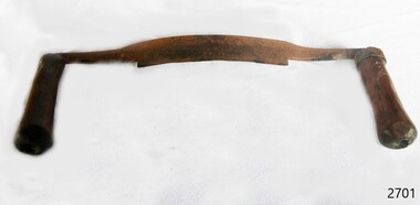 Flagstaff Hill Maritime Museum and Village
Tool - Draw Knife, Prior to 1950
A draw knife or drawing knife, draw shave, shaving knife is a traditional woodworking hand tool used to shape wood by removing shavings. It consists of a blade with a handle at each end. The blade is much longer along the cutting edge than it is deep (from cutting edge to back edge). It is pulled or "drawn" toward the user. A draw knife is commonly used to remove large slices of wood for flat faceted work, to debark trees, or to create roughly rounded or cylindrical billets for further work on a lathe, or it can shave like a spokeshave plane, where finer finishing is less of concern than a rapid result. The thin blade lends itself to create complex concave or convex curves such as in making staves for barrels.A specialised tool used in many different types of wood working and in the making of barrels, this type of tool has been used for many hundreds of years by coopers and other woodworking craftsmen all around the world. It is a tool that has not changed in design during this time and is still used today by craftsmen in the making of wooden barrels for the storage of wines etc. However this item at this time cannot be associated with an historical event, person or place, provenance is unknown, item assessed as a collection asset as it is believed to have been produced before 1950.Draw knife with metal blade and two wooden handlesNoneflagstaff hill, warrnambool, flagstaff-hill, flagstaff-hill-maritime-museum, shipwreck-coast, flagstaff-hill-maritime-village, draw knife, coopers tools, woodworking tools, knife, cooperage -
 Flagstaff Hill Maritime Museum and Village
Spirit level
Spirit level, small, wood with metal around the ends and the glass levels. Comprises both verticle and horizontal levels. Horisontal level is divided into 2 by metal surround. Imperial measurements are impressed into wood on both sides of the ruler.Impreial measurements are impressed into the wood on both sides.flagstaff hill, warrnambool, shipwrecked-coast, flagstaff-hill, flagstaff-hill-maritime-museum, maritime-museum, shipwreck-coast, flagstaff-hill-maritime-village, spirit level, cabinet making, wood working, wood working tool, building tool -
 Flagstaff Hill Maritime Museum and Village
Tool - Wedge
Metal wedge, for use with a plane, has rounded top and flat sides, and a narrow flat end. flagstaff hill, warrnambool, maritime museum, maritime village, wood working tool, wedge, hand tool -
 Flagstaff Hill Maritime Museum and Village
Tool - Plane, 20th century
A special version of the rebate plane, the keel and stem rabbet plane. This was a wider than the usual rebate or rabbet plane, and the blade was set askew to the side to give a slicing action. It was used for cleaning out the rabbet cut from the head of the stem, and along the keel, to take the ends and edges of the planking - its angle varied according to the ship.Rabbet plane. Has a makeshift piece of wood screwed to base to protect it. Made by Sherman Nth York. Blade size 2". A square piece of leather is tacked to top of plane. Red paint markings are on one side.flagstaff hill, warrnambool, shipwrecked-coast, flagstaff-hill, flagstaff-hill-maritime-museum, maritime-museum, shipwreck-coast, flagstaff-hill-maritime-village, rabbet plane., wood working, wood working tools, hand tool -
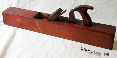 Flagstaff Hill Maritime Museum and Village
Tool - Plane, 19th century
This Jack plane is used for general purposes such as shaving off surplus wood to bring a piece of work down to size and plane the edges of a door to smooth them off. This plane is an example of the tools used by ship builders in the maritime trade from the 19th century to the present day.Jack Plane; a large oblong shape with an aperture at one end, a long wooden guard that protects the sharp metal blade, and a saw like handle at other end. It is stained a red-brown colour.flagstaff hill, flagstaff hill maritime museum and village, warrnambool, maritime museum, maritime village, great ocean road, shipwreck coast, wood working, wood working plane, wood working tool, jack plane, plane, wood plane, general purpose plane, tool, builders tool, carpenter's tool, ship builder's tool, maritime trade -
 Flagstaff Hill Maritime Museum and Village
Tool - Plane, A Mathieson & Son, late 19th to early 20th century
Rabbet plane, without a blade. Made by A Mathieson & Son Glasgow. Size 1.25 inch.Stamped "A MATHIESON & SON / GLASGOW around symbol [Star over crescent]flagstaff hill, warrnambool, shipwrecked-coast, flagstaff-hill, flagstaff-hill-maritime-museum, maritime-museum, shipwreck-coast, flagstaff-hill-maritime-village, flagstaff hill, warrnambool, shipwrecked-coast, flagstaff-hill, flagstaff-hill-maritime-museum, maritime-museum, shipwreck-coast, flagstaff-hill-maritime-village, rabbit plane, wood working tool, hand tool -
 Flagstaff Hill Maritime Museum and Village
Tool - Plane, A. Mathieson and Son, 20th century
Plane Moulding type, maker Mathieson & Son Glasgow. Number 404 plane. Size 5/8 inch. No wedge or blade. Stamped inscriptions.Stamped; "5/8" "No 101" "E DUNSTAN" "2" ["G N" within "W"] "HIT" "E DUNSTAN" Stamped: "A MATHIESON & SON / GLASGOW & EDINBURGH" with symbol [star above crescent] Has E Dunstan HIT stamped on one end. flagstaff hill, maritime museum, maritime village, warrnambool, great ocean road, wood working tool, plane, moulding plane, hand tool -
 Flagstaff Hill Maritime Museum and Village
Tool - Plane
Plane Moulding Grecian Ogee with bevel. Also called Quirk or Quir Ogees. Made by Rabone Bros & Co. Size 1/2 inch. Stamped "RABONE BROS & CO.", and ["G N" within a large "W"]flagstaff hill, flagstaff hill, warrnambool, shipwreck-coast, flagstaff hill maritime mus, flagstaff hill maritime museum, flagstaff hill maritime museum and village, plane, wood working tool, hand tool, moulding plane, grecian orgee, quirk plane, quirk ogees, rabone bros & co. -
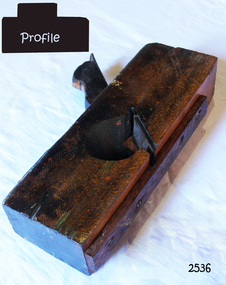
 Flagstaff Hill Maritime Museum and Village
Tool - Complex Moulding Plane, Mid to Late 19th Century
A moulding plane is a specialised plane used for making the complex shapes found in wooden mouldings that are used to decorate furniture or other wooden object. Traditionally, moulding planes were blocks of wear resistant hardwood, often beech or maple, which were worked to the shape of the intended moulding. The blade, or iron was likewise formed to the intended moulding profile and secured in the body of the plane with a wooden wedge. A traditional cabinetmakers shop might have many, perhaps hundreds, of moulding planes for the full range of work to be performed. Large crown mouldings required planes of six or more inches in width, which demanded great strength to push and often had additional peg handles on the sides, allowing the craftsman's apprentice or other worker to pull the plane ahead of the master who guided it.A vintage tool made by an unknown maker, this item was made commercially for firms and individuals who worked in wood and needed a tool that could produce a ornamental finish to timber. These profiled planes came in various shapes and sizes to achieve a decorative finish. Although the item is marked J Dixon no reference can be found at this time for a maker of complex moulding planes J Dixon of London. The plane could have been made by an unknown maker and sold through a merchandising agent of which there was one in London at the time. It is this agent J Dixon that could have stamped his mark on the item and then sold the plane on giving the impression J Dixon was the maker, this practice was quite common in the 18th & 19th centuries. This item is still regarded as a significant tool from the mid to late 19th century that today is quite rare and sought after by collectors. It gives us a snapshot of how furniture and other decorative finishes were created on timber by the use of hand tools. Panel Plough Plane white wood, blade missing. Stamped "J Dixon London" also has the letter "B" stamped flagstaff hill, warrnambool, flagstaff-hill-maritime-museum, maritime-museum, shipwreck-coast, flagstaff-hill-maritime-village, wood working, cabinet making, complex moulding plane, j dixon london, mouldings -
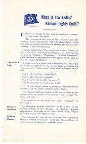 Mission to Seafarers Victoria
Flyer, What is the Ladies' Harbour Lights Guild?, c. 1912
Charity organisation, Ladies' Harbour Lights Guild,was formed within The Missions to Seamen Institute to provide a home away from home, for visiting seamen. The flyer was to recruit members. The flyer mentions the sinking of the Titanic in 1912 and the bravery of the seamen staying in the engine room. The flyer mentions also Lady Talbot Margaret Jane nee Stuart-Wortley (1855-1937), wife of Governor Reginald Taldot, actively promoted advanced social welfare projects.This paper flyer holds historical significance at a local level because it illustrates the Ladies' Harbour Lights Guild involvement in the Mission to Seafarers.The Ladies' Harbour Lights Guild formally named in 1907 grew to become a significant charity in Melbourne raising large amounts of money which helped to establish the current MTSV building, supporting seafarers. In 1960s the LHLG merged with the Flying Angels Club of the MTSV.A cream colour paper flyer describing in blue ink the work and value of membership of The Ladies' Harbour Lights Guild, in order to recruit new members. Also includes a photocopy of the flyer. (2 copies)The photocopy of the original has written in blue "1912". ladies' harbour lights guild, australian wharf, chapel, ephemera, titanic, 1912, lhlg, mission to seamen, seamens' mission, mission to seafarers, alice sibthorpe tracy, reverend alfred gurney goldsmith, philanthropy, charity, welfare, sailors, tragedy, heroism, honorary members, working members, norwegian, foreign language, pit, card game, animal grab, le jeu des animaux, margaret jane (née stuart-wortley), lady talbot, lady margaret jane talbot (nee stuart-wortley), ethel augusta godfrey 1861-1935, knitting, woolies -
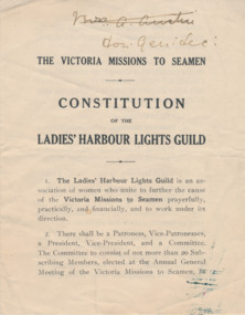 Mission to Seafarers Victoria
Booklet - Constitution, The Victoria Missions to Seamen, Constitution of the Ladies' Harbour Lights Guild, 1916-1920
Small booklet with hand writing in the top right corner on the front reading "Mrs G. Austin" which is crossed out and followed by "Done. Gen. Sec." An ink stain on the bottom right corner. Heading reads, "THE VICTORIA MISSIONS TO SEAMEN. CONSTITUTION OF THE LADIES' HARBOUR LIGHTS GUILD." and is followed by 16 detailed rules."THE VICTORIA MISSIONS TO SEAMEN. CONSTITUTION OF THE LADIES' HARBOUR LIGHTS GUILD." "Mrs G. Austin" crossed out "Don. Gen. Sec." ladies harbour lights guild, constitution, lhlg, honorary members, school members, working members, knights of the guild, subscriptions, rules -
 Flagstaff Hill Maritime Museum and Village
Tool - Wood Moulding Plane, Mid to late 19th century
A moulding plane is a specialised plane used for making complex shapes found in wooden mouldings that are used to decorate furniture or other wooden objects. Traditionally, moulding planes were blocks of wear-resistant hardwood, often beech or maple, which were worked to the shape of the intended moulding. The blade or iron was likewise formed to the intended moulding profile and secured in the body of the plane with a wooden wedge. A traditional cabinetmaker's shop might have many, perhaps hundreds, of moulding planes for the full range of work to be performed. Large crown mouldings required planes of six or more inches in width, which demanded great strength to push and often had additional peg handles on the sides, allowing the craftsman's apprentice or other workers to pull the plane ahead of the master who guided it. This item may be a one off item made by a cabinet maker for a particular project as the plane is not marked resulting in no history or manufacturing provenance available.A vintage tool made by an unknown maker, this item was made commercially and by individual cabinet makers for particular furniture projects that could produce an ornamental finish to timber. The tool was used before routers and spindle moulders came into regular use after World War l l, a time when to produce a decorative moulding for a piece of furniture, door trims, etc or other items had to be accomplished using hand tools and in particular one of these types of planes. These profiled planes came in various shapes and sizes to achieve a decorative finish. A significant early tool that today is quite rare and sought by collectors. It gives us a snapshot of how furniture and other decorative finishes were created on timber by the use of hand tools. Tools that were themselves hand made shows the craftsmanship used during this time not only to make a tool such as the subject item but also the craftsmanship needed to produce a decorative finish that was needed to be made for any timber item.Plane, wooden, narrow blade. Noneflagstaff hill, warrnambool, shipwrecked coast, flagstaff hill maritime museum, maritime museum, shipwreck coast, flagstaff hill maritime village, great ocean road, wooden plane, wood working tool, boat building tool, tool, woodwork tool, plane -
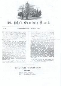 Warrnambool and District Historical Society Inc.
Document, Newsletter St John's church Warrnambool, 1895
St. John’s Presbyterian Church in Warrnambool was opened in 1875 with the Minister in 1895 being the Rev. W. Gray Dixon. At this time the Young People’s Society of Christian Endeavour was active and there was great enthusiasm for supporting missionary work in China and India. This newsletter is of considerable importance as it is an original document and describes the activities of the Presbyterian Church in Warrnambool in the 1890s and gives us some idea of the character of the church at the time. It includes information on Fred Newcombe who later died in India while working as a medical missionary and the names of many people who made their mark in our history. This is a white four-page printed newsletter - St. John’s Quarterly Record, No. 21, Warrnambool, April, 1895. The front page contains an image of St. John’s Church. The printed material includes Church Notes, Marriages, Funerals, Church Register and Disjunctions from Membership. The pages are partly torn.st. john’s presbyterian church,, warrnambool presbyterian church 1895 -
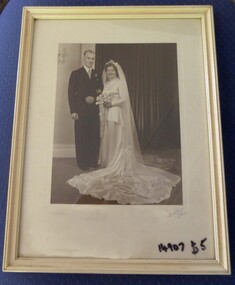 Warrnambool and District Historical Society Inc.
Photograph - Framed Wedding Photograph, Alex Wilkins, Circa 1940’s
An unknown couple on their wedding day, photographed by Warrnambool photographer, Alex Wilkins. Alex was popular as a photographer and produced a large volume of work. This photograph was purchased by Les and Elizabeth O'Callaghan at a cost of $5. It is thought to be members of the Cassady family.The photo depicts styles of wedding dress popular in the 1940’s. Alex Wilkins commenced his photographic career working for a local chemist and worked for some time from a studio at 151 Fairy Street Warrnambool and in 1938 purchased the studio of Arthur Jordan and moved to Liebig Street. The business was sold in 1961 and for some time after he operated in a small studio and worked shooting film for local TV channels. Alex died in 1972 after a short illness. Sepia wedding photograph depicting bride and groom, in cream wooden frame with cream mount. A.Wilkins, W’Bool.warrnambool, warrnambool wedding, alex wilkins -
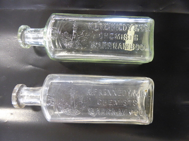 Warrnambool and District Historical Society Inc.
Bottle, R F Kennedy & Co x2, Early 20th century
These bottles were used in the Warrnambool pharmacy of R. F. Kennedy & Co. Richard Frank Kennedy (1826-1903) was born in England and came to Warrnambool in the early 1880s, establishing a pharmacy in Timor Street. This was a retail, wholesale and manufacturing business. In 1891 Kennedy erected a new building which was described as one of the most elegant and best-stocked chemist’s shops in Victoria. Kennedy was active in Warrnambool community affairs and was a foundation member of the Warrnambool Bowls Club, being its first Vice-President and an early President. His business continued on after his death, trading as ‘R.F.Kennedy and Co.’ Richard Frank Kennedy was one of the most significant businessmen in Warrnambool in the late 19th century. The products of his shop and factory were distributed all over Victoria and beyond. These bottles are good examples of the types used in the Kennedy pharmacy. They show the well-known Kennedy lighthouse symbol. Warrnambool still has two working lighthouses today. These are two clear glass chemist’s bottles. They are identical in size and shape. They have a rectangular-shaped body with rounded edges, a circular-shaped neck and a moulded top with an opening. There are no stoppers. The sides of the bottles have the Kennedy logo of a lighthouse on a rocky cliff on the coastline with ships in the distance and the name of the chemist (R.F.Kennedy). ‘2/3 viii’ ‘R.F.Kennedy & Co. Chemists Warrnambool’ ‘L 389 M’ ‘A.G.M.’ r.f.kennedy,, warrnambool chemist, chemists in warrnambool, history of warrnambool -
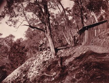
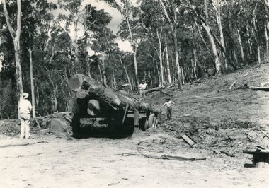 Kiewa Valley Historical Society
Photo - Mountain Creek Logging Camp, 1955
Hume and Hovell discovered the area in 1824 and by the end of the 19th century the valley was transformed by logging, dairy and beef cattle properties and tobacco farms. The logs could have been milled for timber at the State Electricity Commission's mill at Howman's Gap which provided a much needed source of timber for construction of McKay Creek Power Station which began construction in 1951 and also the camps and houses for the workers and their families. There was a need for housing and infrastructure for an increasing population of workers for the hydro-electric scheme as there was a general shortage of this commodity. A timber mill was started in Tawonga by Mates, of Albury, in 1945, and electricity became available in 1946 the S.E.C. bought the mill, and enlarged it. In 1960 it was purchase by a local family, they also started a timber mill in Mt Beauty worked both until 1980 when they closed it. The Tawonga mill and enlarged the mill called Mt. Beauty Timbers Pty Ltd employed approximately 50 people. An historical pictorial record of the general working conditions, type of machinery and vehicles in use in the 1950’s. Note the lack of protective clothing!Black and white photograph of the logging camp at Mountain Creek. November 1955Handwritten on the back of photograph - MOUNTAIN CREEK LOGGING CAMP NOV 55mountain creek logging camp, timber industry, tawonga