Showing 1515 items
matching aerial photographs
-
 Glenelg Shire Council Cultural Collection
Photograph - Photograph - aerial view of Portland Hanrbour, n.d
... Photograph - aerial view of Portland Hanrbour...Aerial black and white photograph showing construction... pencil border. Aerial black and white photograph showing ...Port of Portland AuthorityBack: Reduce to 52cms wide and 30cms deep - pencil ruled pencil border.port of portland archives, aerial photography, portland harbour -
 Phillip Island and District Historical Society Inc.
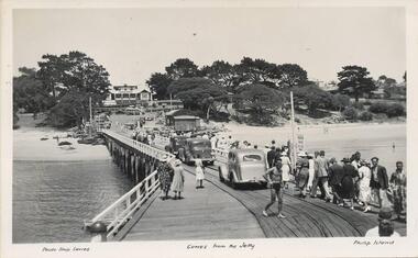
Photograph - Post Cards, A. J. Murray et al, c 1940
... . Black & White aerial photograph of "Broadwater" Guesthouse... in background. Sheds at end. Photograph 228-02. Black & White aerial ...A collection of 6 postcards and 1 photograph taken around Phillip Island. Donated by Julie Barnett.Photograph 228-01. Black & White photograph of the Cowes Pier with vehicles and pedestrians. Rail tracks on pier. Isle of Wight Hotel in background. Sheds at end. Photograph 228-02. Black & White aerial photograph of "Broadwater" Guesthouse, Cowes. Photograph 228-03. Black & White photograph of Cowes Pier with Steamer coming in. Shed at end of Jetty and Cenotaph in the foreground. Looking north. Photograph 228-04. Black & White photograph of a Koala and her young. Photograph 228-05. Black & White photograph looking over the Cowes shoreline near Lover's Walk. Photograph 228-06. Black & White photograph of a group of penguins coming home at dusk at the "Penguin Parade". Photograph 228-07. Black & White photograph of Bert West holding a Shearwater (Mutton Bird) with it's wings outstretched.Photo 01. "Photo Shop Series". "Cowes from the Jetty". Photo 02. Aerial view of "Broadwater" Cowes, Phillip Island. No. 146 Photo 03. "Photo Shop Series". The Jetty. Cowes. Photo 04. "Photo Shop Series". "Koala Bear". Phillip Island Photo 05. "The Rose Series P3416". "Near the Lovers' Walk, Cowes, Phillip Is., Vic. Photo 06. "Penguins, Phillip Island." No. 82. Valentines Series. Photo 07. On Back: Mr West with Mutton bird at Phillip Island.wildlife - koalas, wildlife - penguins, penguin parade, bert west, wildlife - mutton birds, mutton birds, shearwaters, cowes pier phillip island, cowes jetty, lover's walk cowes, broadwater guesthouse cowes phillip island, guesthouses cowes phillip island, julie barnett -
Bendigo Historical Society Inc.
Photograph - Aerial shots of parts of Bendigo 1934, 1934
... This document contains scans of a unique set of aerial photographs... of aerial photographs that were taken over the City of Bendigo ...AERIAL SHOTS OF PARTS OF BENDIGO 1934 Catalogue No.10584 This document contains scans of a unique set of aerial photographs that were taken over the City of Bendigo on Friday 12th January 1934, at about midday. The photographs were commissioned by Bendigo Mines Limited during their exploration and mining program designed to revitalize the Bendigo Goldfield. The photographs were given to the Victorian Mines Department sometime in the 1950s. The photographs were taken at a relatively low level of about 4000 feet. This gives a very detailed picture of Bendigo as it was in the 1930s. The photos cover the City Centre and are mainly of the goldfields on the south side of the city; the extent of which covers approximately the four corners of Myers Flat, Maiden Gully, Mandurang and One Tree Hill. Streets, roads and places of interest have been identified as best as possible in December 2023. There are 44 maps, and each references the adjoining maps.Typed Notes with CD The CD is one of two and contains a set of 46 images: The folder named "High_Resolution_800dpi" contains the original digital files that were produced by scanning the photographic prints (About A3 size) at 800 dpi using a high quality, large pformat, roll scanner. These files may be too large for some computers. A second CD contains a direstory called "Low_Resolution_300dep" The images in the folder names "Low_Reolution_300dpr" have a lower resolution (300 dpi) and have been rotated 90 degrees clockwise so that the Northern margin of each image is a the top of the screen. Clive Willman Senior Geologist Geological Survey of Victoriahistory, bendigo, bendigo mines, bendigo maps, bendigo aerial photos -
 Eltham District Historical Society Inc
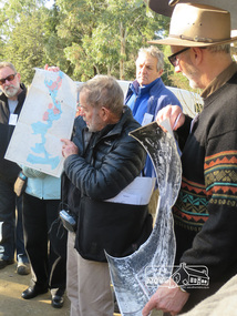
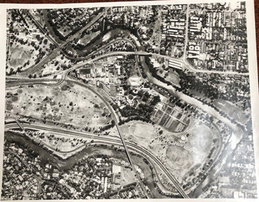
Photograph, Liz Pidgeon, Heritage Excursion; Eltham Lower Park Walk and Talk, 1 July 2017, 1 July 2017
... Connor with a map and aerial photograph of the area the heritage... Connor with a map and aerial photograph of the area the heritage ...Local Historian Russell Yeoman and EDHS President Jim Connor with a map and aerial photograph of the area the heritage walk will cover. Newsletter No., 234, June 2017 Heritage Excursion - Saturday 1st July - Eltham Lower Park - Walk and Talk Eltham Lower Park has played an important part in the history of our area since the early days of European settlement when it was used by local residents as an informal racecourse. Prior to that its location at the junction of the Diamond Creek and the Yarra River made it an important meeting place for the Wurundjeri people. The park combines formal elements and sporting facilities with remnant bushland that is of environmental significance. It is home to sporting and horse riding clubs, popular play spaces and the Diamond Valley Miniature Railway, which attracts large numbers of visitors. The park will be the venue for our July excursion which will comprise a walk of about 3.5 km around the park and adjacent areas. Along the way we will discuss the history and natural history of the area. The path along the creek and the river provides a pleasant and scenic walk. This walk on Saturday 1st July is about 3.5 km in length and will take 2 to 2.5 hours. It will start at 2pm at the Main Road car park at the front of the park. (Melway ref 21 H 10). Born Digitalheritage excursion, activities, eltham district historical society, eltham lower park, russell yeoman, jim connor, guide -
 Ballarat Tramway Museum
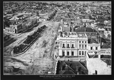
Photograph - Black & White copy, William Bardwell, "Ballarat looking east from the Town Hall ca 1872"
... Black & White copy photograph aerial view A4 size, titled... St Black & White copy photograph aerial view A4 size, titled ...Original photograph by William Bardwell, with the original image held by the State Library of Victoria. Edited by Richard Conn. Purchased by the Museum.Provides information about the appearance of Sturt St Ballarat, looking from the Town Hall. Shows the topography of the area, along with many buildings, including the London Chartered Bank of Australia (later the Commonwealth Bank), the Unicorn Hotel, J. Dodds Bucks Head Hotel, road works in Bridge St, Albion House Drapery, Bryce & Chalmers Produced Merchants, a fenced central median strip and two horse-drawn carriages parked in Lydiard St.Black & White copy photograph aerial view A4 size, titled ""Ballarat looking east from the Town Hall ca 1872" looking along Sturt St towards Grenville St. Original photo by William Bardwell.ballarat, sturt st, grenville st, lydiard st, bucks head hotel, bryce & chalmers, london chartered bank, albion house, bridge st -
 Kiewa Valley Historical Society
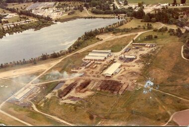
Photograph - Mt Beauty timber Industries, 1960's (estimate only)
... Colour photograph of aerial view of Mt Beauty Timber Mills... Beauty Operations Colour photograph of aerial view of Mt Beauty ...Hume and Hovell discovered the area in 1824 and by the end of the 19th century the valley was transformed by logging, dairy and beef cattle properties and tobacco farms. Timber was required for construction of McKay Creek Power Station which began construction in 1951 and also the camps and houses for the workers and their families. There was a need for housing and infrastructure for an increasing population of workers for the hydro-electric scheme as there was a general shortage of this commodity. A timber mill was started in Tawonga by Mates, of Albury, in 1945, and electricity became available in 1946 the S.E.C. bought the mill, and enlarged it. In 1960 it was purchase by a local family. They also started a timber mill in Mt Beauty and worked both until 1980 when they closed the Tawonga mill and enlarged the mill called Mt. Beauty Timbers Pty Ltd which employed approximately 50 people. A pictorial record of the development of the Mt Beauty community and the local timber industry.Colour photograph of aerial view of Mt Beauty Timber Mills and surrounding area including pondage and part of airfield. Photo taken in 1960’s (estimate only)Handwritten in ink on back of photograph in very faint writing – Recent photo of Mt Beauty Timber Industries Mt Beauty Operationsmt beauty timber industry, timber industry, timber mill, secv -
Glenelg Shire Council Cultural Collection
Photograph - Photograph - View of Port of Portland, 21/03/1972
... Unframed, aerial, black and white photograph. Cape Nelson...: (no inscriptions) Back: 21/3/1972 Unframed, aerial, black and white ...Port of Portland Authority archives.Front: (no inscriptions) Back: 21/3/1972port of portland archives, portland harbour, cape nelson road, canal, railway, canal court, henty park -
 University of Melbourne, Burnley Campus Archives
Photograph - Black and white print, Aerial View of Burnley Campus C.1970, c. 1970
... Colour photograph of black and white photograph. Aerial... photograph. Aerial View of Burnley Campus. Enlargement. Shows ...Colour photograph of black and white photograph. Aerial View of Burnley Campus. Enlargement. Shows position of Campus in bend of Yarra River after alterations to the position of the river due to building of Freeway, new ovals and Richmond Public Golf Course.burnley campus, aerial view, yarra river, richmond public golf course -
 Lakes Entrance Regional Historical Society (operating as Lakes Entrance History Centre & Museum)
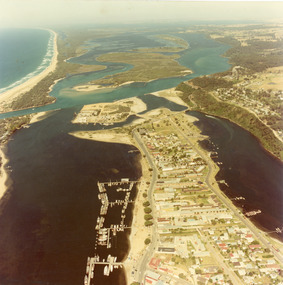
Photograph - Lakes Entrance, 1980c
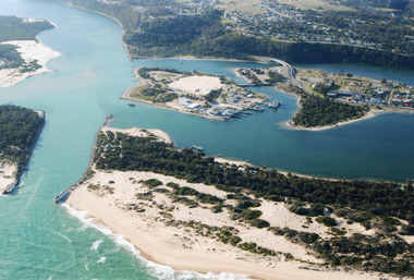
... Colour photograph aerial view of township of Lakes Entrance...Waterways Township Bridges Colour photograph aerial view ...Colour photograph aerial view of township of Lakes Entrance, showing western end of town, Bullock Island, Cunninghame Arm and North Arm, man made entrance, and distant view of outer barrier, island and shoreline. Lakes Entrance Victoriawaterways, township, bridges -
 Bendigo Military Museum
Photograph - Aerotriangulation Production – Army Survey Regiment, Fortuna, Bendigo, c1979
... , tie, and survey control points on aerial photographs. The OMI..., tie, and survey control points on aerial photographs. The OMI ...This collection of 19 photos was most likely taken in 1979 in Air Survey Squadron. The PDP 11/70 minicomputer shown photos .2P to .3P was the operating system introduced in 1977 as the mainframe system for the control of the APC4, aerial triangulation block adjustments, SORA OP Analytical Orthophoto control, APR Analytical Terrain Profile Recorder computation, graphics, and general computing. The Zeiss (Jena) Stecometer analytic stereocomparator for air photography shown in photos .5P to .9P was introduced at Air Survey Squadron in 1963. Aerotriangulation production was expedited using computers for analytical photogrammetric processes. The technician accurately measured between pass, tie, and survey control points on aerial photographs. The OMI/Nistri AP/C-3 analytical plotter shown in photos .10P and .11P was introduced in 1972–1973. Photo .11P shows a coordinatorgraph attached to the AP/C-3. The Zeiss D2 Planimat Stereoplotter shown in photo .12P was used for analytical orthophoto control. Wild PUG4 point transfer devices shown in photos .17P to .19P were introduced in c1968 superseding the PUG2 devices. PUG4 devices were used by technicians to stereoscopically view the photography containing the survey control points and the mapping aerial photography. The Control points were transferred from the control photography to the mapping diapositives of aerial photography by drilling their locations into the photographic emulsion.This is a set of 19 photographs of Air Survey Squadron personnel operating aerotriangulation equipment at the Army Survey Regiment at Fortuna, Bendigo, c1979. Black and white photos are on photographic paper and were scanned at 300 dpi. They are part of the Army Survey Regiment’s Collection. .1) - Photo, black & white, c1979, Aerotriangulation tasks, unidentified technicians. .2) to .3) - Photo, black & white, c1979, PDP-11 minicomputers tasks, unidentified technician. .4) - Photo, black & white, c1979, Aerotriangulation tasks, unidentified technician. .5) - Photo, colour, c1979, Zeiss (Jena) Stecometer, unidentified technician. .6) to.9) - Photo, black & white, c1979, Zeiss (Jena) Stecometer, unidentified technician. .10) - Photo, black & white, c1984, OMI/Nistri APC/3-1 analytical stereoplotter, SPR Kristin (Isaac) Skidmore. .11) - Photo, colour, c1979, OMI/Nistri APC/3-1 analytical stereoplotter, unidentified technician. .12) - Photo, colour, c1979, Zeiss D2 Planimat Stereoplotter, unidentified technician. .13) - Photo, black & white, c1979, Aerotriangulation tasks, unidentified technician. .14) - Photo, black & white, c1979, Aerotriangulation tasks, unidentified technician. .15) - Photo, black & white, c1979, Aerotriangulation tasks, CPL Ken Talbot-Smith .16) - Photo, black & white, c1979, Aerotriangulation tasks, SPR David Jobe. .17) - Photo, black & white, c1979, Wild PUG4 point transfer device, WO2 Brian Mead. .18) - Photo, black & white, c1979, Wild PUG4 point transfer device, CPL Andy Wilson. .19) - Photo, black & white, c1979, Wild PUG4 point transfer device, unidentified technician..5P is annotated ‘OMI-Nistri AP/C Analytical Plotter’ and ’Topo 36’. .12P is annotated ‘Zeiss Jena Stecometer Stereocomparator’ and ’Topo 35’. There are no annotations on the other photos.royal australian survey corps, rasvy, army survey regiment, army svy regt, fortuna, asr, aerotrig, air survey -
 Bendigo Historical Society Inc.
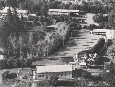
Photograph - FORTUNA COLLECTION - PHOTOGRAPH
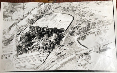
... Black and white photograph, aerial view of part of grounds... Black and white photograph, aerial view of part of grounds ...Black and white photograph, aerial view of part of grounds showing some buildings, partial view of lake and partial view of Fortuna Villa. Writing in pen on back of photo (top left hand side) is an inscription stating 'approx 1962-3'. -
Glenelg Shire Council Cultural Collection
Photograph - Photograph - View of Portland and foreshore, 21/03/1972
... Unframed, aerial, black and white photograph, taken from...: (no inscriptions) Back: (no inscriptions) Unframed, aerial, black and white ...Port of Portland Authority archives.Front: (no inscriptions) Back: (no inscriptions)port of portland archives, portland harbour -
Glenelg Shire Council Cultural Collection
Photograph - Photograph - View of port, c. 1973
... Unframed, aerial black and white photograph, taken from...: (no inscriptions) Back: (no inscriptions) Unframed, aerial black and white ...Port of Portland Authority archives.Front: (no inscriptions) Back: (no inscriptions)port of portland archives -
Glenelg Shire Council Cultural Collection
Photograph - Photograph - Portland central township and Portland Harbour, 05/03/1971
... Unframed aerial black and white photograph taken from...) Unframed aerial black and white photograph taken from the west ...Port of Portland Authority archivesFront: (no inscriptions) Back: (no inscriptions)port of portland archives, portland harbour, portland central town, no6 berth development, ocean pier demolition, baths demolition -
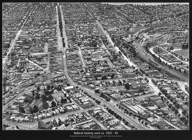 Ballarat Tramway Museum
Photograph - Black & White copy, Charles Pratt, "Ballarat looking west ca 1925-40"
... Black & White copy photograph aerial view A4 size, titled... Sturt St victoria St Black & White copy photograph aerial view ...Original photograph by Charles Daniel Pratt, with the original image held by the State Library of Victoria. Edited by Richard Conn. Purchased by the Museum.Provides information about the appearance of Ballarat East and views across over the Railway Station to Lake Wendouree and along along Sturt St. Shows the nature of the Bridge St shopping centre and other places.Black & White copy photograph aerial view A4 size, titled "Ballarat looking west ca 1925-40" - looking along Sturt St with the Railway yards, Bridge St and Victoria St in the view. Some trams can be seen at Grenville St.ballarat, aerial photo, sturt st, victoria st -
 Bendigo Military Museum
Photograph - Photogrammetric Equipment – Army Survey Regiment, Fortuna, Bendigo, c1960s to c1980s
... , and survey control points on aerial photographs. The Wild B9 and B8s..., tie, and survey control points on aerial photographs. The Wild ...This is a set of eight photographs of technicians operating photogrammetric equipment in Air Survey Squadron, Army Survey Regiment, Fortuna, Bendigo. c1960s to c1980s. The Wild A9 Stereocomparator and Wild B9 stereo plotter were introduced in 1962. The Wild B8 stereo plotter was introduced in 1966. Technicians used the Wild A9 Stereocomparator to accurately measure between pass, tie, and survey control points on aerial photographs. The Wild B9 and B8s were used for plotting topographic detail and contours. These analogue machines were manually controlled by adjusting the control knobs for the orientation of the 3D image. The B9s used a four and a half square, and the B8s used a nine-inch square photo image on a film or glass diapositive which allowed highly accurate extraction of map features. At first, plotting with B8 and B9 stereo plotters was undertaken at the aerial photography scale of 1:80,000 in pencil onto a controlled plotting sheet. Sheets were then inked up and reduced photographically to the 1: 100,000 publication scale for scribe impression production. In the early days topographic detail and contours were plotted with a pencil or ink pen mounted at the far end of the pantograph arm. The plotting procedure was upgraded to direct plotting in ink with photographic reduction to publication scale. In 1975 four B8s were upgraded with tri-axis locaters as part of the Input Sub-system to enable digital extraction to AUTOMAP 1’s topographic database. When AUTOMAP 2 was introduced in 1982 these B8s were upgraded, and additional machines added to expand the Army Survey Regiment’s digital capture capability. This is a set of eight photographs of technicians operating photogrammetric equipment in Air Survey Squadron, Army Survey Regiment, Fortuna, Bendigo. c1960s to c1980s. Black and white and colour photos are on photographic paper and scanned at 300 dpi. .1) - Photo, black & white, c1965. Unidentified technician operating a Wild A9 Stereocomparator. .2) - Photo, black & white, c1965. Unidentified technician operating a Wild B9 stereo plotter. .3) - Photo, black & white, c1967. L to R: Unidentified technician, SPR Ken Jeffery operating a Wild B9 stereo plotter. .4) - Photo, colour, c1974. Unidentified technician, operating a Wild B8 stereo plotter. .5) - Photo, black & white, c1974. Unidentified technician operating a Wild B8 stereo plotter. .6) to .7) - Photo, black & white, c1979. Unidentified technicians operating a Wild B8 stereo plotter. .8) - Photo, black & white, c1985. Unidentified technician in AUTOMAP 2 operating a Wild B8 stereo plotter..1P, .2P, .4P, .5P, .7P – no annotations. .3P – annotated ‘Standing - , Seated SPR Ken Jefferies (sic). .6P – annotated with date ‘1979’ .8P – annotated ‘AUTOMAP 2’royal australian survey corps, rasvy, army survey regiment, army svy regt, fortuna, asr, air survey, photogrammetry -
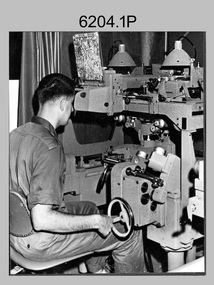
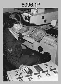 Bendigo Military Museum
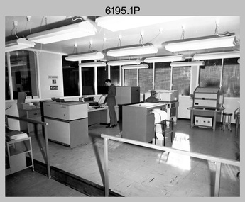
Photograph - Army Survey Regiment – Map Production, Fortuna, Bendigo, c1980s
... aerial photographs with a stecometer. .2) - Photo, colour, c1980s... De Zee) De Groot measuring aerial photographs ...These five photographs of map production and the car park area were taken at Fortuna, Bendigo, c1980s. The first three photographs were taken in Air Survey Squadron, where aerotriangulation and digital photogrammetric extraction of topographic features from aerial photography were undertaken. Photo .4P was taken in Cartographic Squadron’s Correcting Section, located in the Attic. The technicians were probably involved in a rapid response map production, as they all were wearing field uniforms. The Army Survey Regiment’s Duty Room, RAP and Carpark appear in Photo .5P. It was probably taken from the top steps near the SGT’s accommodation block in 1986. Photos .4P and .5P are also published with item 6395.17P.This is a set of five photograph of Map Production and car park, at the Army Survey Regiment, Fortuna, Bendigo, c1980s. The photographs were printed on photographic paper and is part of the Army Survey Regiment’s Collection. Photograph .1P was scanned at 200 dpi. The others were scanned at 300 dpi. .1) - Photo, black & white, c1980s: CPL Marrianne (Van De Zee) De Groot measuring aerial photographs with a stecometer. .2) - Photo, colour, c1980s: Two unidentified technicians assessing a flight line diagram. .3) - Photo, black & white, c1980s: SPR Scheryl Delforce digitising map features on an AUTOMAP 1 Graticon table. .4) - Photo, black & white, 1986: L to R: CPL Andy Lucas, SPR Chris Gordon, unidentified, SPR Jan (Crighton) Minchin, SPR Robin Marshall, CPL Frank Downie, SPR Gayle Humphrey, unidentified technicians in the Attic, Fortuna. .5) - Photo, black & white, 1986: Army Survey Regiment Duty Room, RAP and Carpark at Fortuna. .1P - Annotated on back ‘Maryanne Degroot’ .2P, .4P to .5P – no annotation .3P - Annotated on back ‘Scheryl Delforce’royal australian survey corps, rasvy, army survey regiment, army svy regt, fortuna, asr, air survey, carto, aerotrig -
 Bendigo Historical Society Inc.
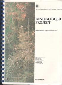
Booklet - Kangaroo Flat Gold Mine Collection: Western Mining Corporation Bendigo Gold Project Environmental Effects Statement December 1987, Western Mining Corporation, Bendigo Office, Western Mining Corporation Limited Bendigo Gold Project Environment Effect Statement December 1987, December 1987
... aerial photograph of Bendigo mining areas mentioned in report..., December 1987. On front page, colour aerial photograph of Bendigo ...Spiral bound booklet, plastic cover, black plastic binding, On front cover: Western Mining Corporation Bendigo Gold Project, Environment Effects Statement, December 1987. On front page, colour aerial photograph of Bendigo mining areas mentioned in report. Key on front page related to photograph: 1. Woodvale Evaporation Ponds. 2. New Moon area. 3. North New Chum Williams United shaft. 4. Carshalton, Carshalton shaft. 5. South Nell Gwynne, North Bendigo shaft. Contents: historical perspective; Western Mining Corporation Ltd Bendigo activities; project outline, project approvals - controlling factors, elements of the mining project, surface based exploration, underground operations and surface support, mining areas and operations ore and mullock haulage, New Moon area, water management, environmental management. Planning and land use, socio-economic environment, physical environment and biological environment are examined and discussed. bendigo, goldmining, bendigo mining nl, bendigo goldfield, environmental effects statement, bendigo gold project, woodvale evaporation ponds, new moon, north new chum, carshalton, south nell gwynne, western mining corporation -
Glenelg Shire Council Cultural Collection
Photograph - Photograph - Aerial view from N.W. Port of Portland, 05/03/1971
... Photograph - Aerial view from N.W. Port of Portland...b x w photograph - unframed. Aerial view from N.W. Port... Development. Fishermens' facilities. Photograph Photograph - Aerial ...Port of Portland Authority archives.Front: (no inscriptions) Back: (no inscriptions)port of portland archives, portland harbour -
 University of Melbourne, Burnley Campus Archives
Photograph - Black and white print, Aerial View of Burnley Campus c. 1930, c. 1934
... Black and white photographs. Aerial Views of Burnley Campus... November 1934. Aerial View of Burnley Campus c. 1930 Photograph ...Black and white photographs. Aerial Views of Burnley Campus. Enlargements. (A) Heyington Bridge to South, Yarra River on North side. (B) Heyington Bridge at top of photograph i.e. reverse view of (A). (C) Original of (B) mounted on board. Probably taken at the time of the floods of 30 November 1934. heyington bridge, yarra river, aerial view, burnley campus, 1934 flood -
Glenelg Shire Council Cultural Collection
Photograph - Photograph - NNW of Portland Harbour, 21/03/1972
... Unframed aerial black and white photograph taken from NNW...: (no inscriptions) Back: (no inscriptions) Unframed aerial black and white ...Port of Portland Authority archives.Front: (no inscriptions) Back: (no inscriptions)port of portland archives -
Glenelg Shire Council Cultural Collection
Photograph - Photograph - NNW of Portland Harbour, 21/03/1972
... Unframed aerial black and white photograph taken from NNW...) Unframed aerial black and white photograph taken from NNW ...Port of Portland Authority archives.Front: (no inscriptions) Back: (no inscriptions)port of portland archives, portland harbour, south portland, cape nelson, no6 berth construction, cresco fertilizer, s l patterson wharf -
Glenelg Shire Council Cultural Collection
Photograph - Photograph - NNW of Portland Harbour, 21/03/1972
... Unframed aerial black and white photograph taken from NNW...: (no inscriptions) Back: (no inscriptions) Unframed aerial black and white ...Port of Portland Authority archives.Front: (no inscriptions) Back: (no inscriptions)port of portland archives, portland harbour, south portland, cape nelson, cresco fertilizer, s l patterson wharf -
 Old Colonists' Association of Ballarat Inc.
Photograph - Photograph - Colour, N.L. Harvey, Old Colonists' Association of Ballarat Cottages, 1958, 1958
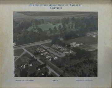
... Aerial Photograph of the Old Colonists' Association...' Association Ballarat Charles Anderson Grove Retirement Village Aerial ...Aerial Photograph of the Old Colonists' Association of Ballarat Cottages at Charles Anderson Grove. One of the first objectives of the Association was "to provide the shelter of a hose for those Pioneers of the Goldfields whom the reverses of fortune have deprived of the means of procuring the comforts of life in their declining years." The first home at Charles Anderson Grove was built in 1925. Before that time the Association provided relief for needy pioneers. relief included monthly monetary payments, loads of firewood, medical assistance and distribution of Christmas bosed of groceries to deserving pensioners, and in some cases payment of burial costs. ::a) The dominant purpose of the Association is to give public benevolent relief as a charity, but providing independent living accommodation in our Retirement Village for person in need who are over 65. ::b) To raise funds by membership subscription, commercial and residential rents, donations, gifts and voluntary work, for the purpose of providing direct relief of poverty, distress, misfortune or helplessness. ::c) To maintain the important heritage and ongoing viability of the Old Colonists' Association. (Revised Rules of the Old Colonists' Association of Ballarat Inc., 2016) old colonists' association, ballarat, charles anderson grove, retirement village -
 Old Colonists' Association of Ballarat Inc.
Photograph, N.L. Harvey, Old Colonists' Association of Ballarat Cottages, 1958, 1958
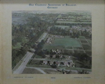
... Aerial photographs of the Old Colonists' Association... Aerial photographs of the Old Colonists' Association of Ballarat ...Aerial photographs of the Old Colonists' Association of Ballarat Cottages at Charles Anderson Grove. One of the first objectives of the Association was "to provide the shelter of a hose for those Pioneers of the Goldfields whom the reverses of fortune have deprived of the means of procuring the comforts of life in their declining years." The first home at Charles Anderson Grove was built in 1925. Before that time the Association provided relief for needy pioneers. relief included monthly monetary payments, loads of firewood, medical assistance and distribution of Christmas bosed of groceries to deserving pensioners, and in some cases payment of burial costs. ::a) The dominant purpose of the Association is to give public benevolent relief as a charity, but providing independent living accommodation in our Retirement Village for person in need who are over 65. ::b) To raise funds by membership subscription, commercial and residential rents, donations, gifts and voluntary work, for the purpose of providing direct relief of poverty, distress, misfortune or helplessness. ::c) To maintain the important heritage and ongoing viability of the Old Colonists' Association. (Revised Rules of the Old Colonists' Association of Ballarat Inc., 2016) old colonists' association of ballarat, charles anderson grove, retirement village -
 Melbourne Tram Museum
Photograph - Compact Diskette with photographs, Kevin O'Reilly, "Flyers of Time K'O'Reilly - Tram shots collected", 2012
... of aerial photographs of Ballarat (2) and Melbourne ( 15 ) Disc...) containing a series of aerial photographs of Ballarat (2 ...CD (Compact Diskette for use in computers) (108mm diameter plastic disc with plastic case and cover) containing a series of aerial photographs of Ballarat (2) and Melbourne ( 15 ) Disc has the hi-resolution TIF files and jpg file. Files in order on CD: Ballarat 5 - copy sent to the Ballarat Tramway Museum - images on this record as tiff files. Ballarat - ditto Eliz St - see htd136 for image Kew Barkers Road - see htd137 for image Kew Burke Rd - see htd138 for image Kew Junction - see htd139 for image Merri Creek - see htd140 for image Richmond 6 - see htd141 for set of three images Richmond 7 - see htd142 for image Richmond - see htd141 for set of three images Richmond3- see htd141 for set of three images Royal Park 2 - see htd143 for image Sandringham - see htd144 for image Scotch - see htd145 for image Spencer - see htd146 for image St Kilda 1 - see htd147 for image St Kilda - see htd148 for imagetrams, tramways, melbourne -
 Lakes Entrance Regional Historical Society (operating as Lakes Entrance History Centre & Museum)
Photograph - Lakes Entrance, 2000
... Colour photograph aerial view of the entrance, shows entry...Islands Waterways Hotels Bridges Colour photograph aerial ...Colour photograph aerial view of the entrance, shows entry to North Arm, Cunninghame Arm, Bullock Island, part of Rigby Island, new North Arm Bridge in place, Club Hotel still in situ, small dredge working south west corner of Bullock Island. Lakes Entrance Victoriaislands, waterways, hotels, bridges -
Glenelg Shire Council Cultural Collection
Photograph - Photograph - View of port and facilities, c. 1974
... Aerial black and white photograph, taken from the south...: (no inscriptions) Back: (no inscriptions) Aerial black and white photograph ...Port of Portland Authority archives.Front: (no inscriptions) Back: (no inscriptions)port of portland archives, portland harbour -
 Lakes Entrance Regional Historical Society (operating as Lakes Entrance History Centre & Museum)
Photograph - Lakes Entrance, 2000
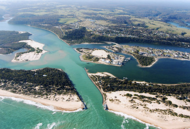
... Colour photograph of aerial view of the entrance at Lakes...Waterways Township Topography Colour photograph of aerial ...Colour photograph of aerial view of the entrance at Lakes Entrance, shows part of Rigby Island, Bullock Island, North Arm, Cunninghame Arm and buildup of sand on ocean shores of sand hummocks. Lakes Entrance Victoria waterways, township, topography -
 Lakes Entrance Regional Historical Society (operating as Lakes Entrance History Centre & Museum)
Photograph - Lakes Entrance, Bulmer H D, Whiters Camp Park, 1940c
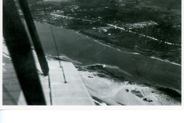
... Black and white copy photograph of aerial view of eastern...Waterways Township Black and white copy photograph ...Black and white copy photograph of aerial view of eastern approach, showing Princes Highway, Whiter's Camp Park, sandy outer barrier beside Cunninghame Arm, distant view of North Arm. Lakes Entrance Victoriawaterways, township