Showing 110528 items
matching roads
-
 Eltham District Historical Society Inc
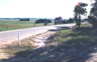
Slide, Bonds Road, Lower Plenty, Mar. 1981
... roads ...One of a series of images of road infrastructure focussed on Bonds Road, Lower Plenty, the section connecting Old Eltham Road with Rosehill Road, taken by Eltham Shire Council Planning and Engineering officers. They provide perspective of the changes in housing styles and road development that began sweeping in from the mid 1970s with increasing urbanisation of what was once more outlying suburbs and regions. All images have been identified with GPS35 mm colour positive transparency (1 of 13) Mount - Kodak Kodachrome CardProcessed Mar 1981infrastructure, roads, bonds road, lower plenty -
 Eltham District Historical Society Inc
Slide, Bonds Road, Lower Plenty, Mar. 1981
... roads ...One of a series of images of road infrastructure focussed on Bonds Road, Lower Plenty, the section connecting Old Eltham Road with Rosehill Road, taken by Eltham Shire Council Planning and Engineering officers. They provide perspective of the changes in housing styles and road development that began sweeping in from the mid 1970s with increasing urbanisation of what was once more outlying suburbs and regions. All images have been identified with GPS35 mm colour positive transparency (1 of 13) Mount - Kodak Kodachrome CardProcessed Mar 1981infrastructure, roads, bonds road, lower plenty -
 Ringwood and District Historical Society
Newspaper, Scrapbook Clipping, Library Collection, Ringwood, Victoria
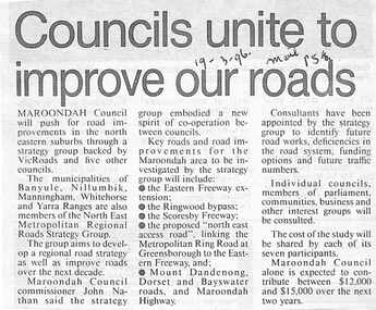
Newspaper Clipping from The Mail, 19-3-96, P 5. Councils unite to improve our roads.Maroondah Councilwill push for road improvements in the north eastern suburbs through a strategy group backed by Vicroads and five other councils. The municipalities of Banyule, Nillumbik, Manningham, Whitehorse and Yarra Ranges are also members of North East Metropolitan Regional Roads Strategy Group. -
 Kew Historical Society Inc
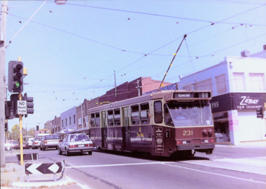
Photograph - A Class 231 in Doncaster Road, North Balwyn Village, 1990
This colour photograph, with 15 others are enlargements gifted to the Society by Mel Lawrence in 2016. They were taken at a commemorative event from the Kew Tram Depot. Laminated colour enlargement of an A Class 231 in Doncaster Road, North Balwyn Village during a re-enactment from the Kew Depot in 1990.Annotation reverse: "Kew Depot 1990. A Class 231 in Doncaster Road, North Balwyn Village."kew tram depot, a class trams, trams -- melbourne -
 Mt Dandenong & District Historical Society Inc.
Photograph, Jeeves Coach on CRB Road at Foot of Farringdon Road Kalorama, 1920, 1920
Scene looking down Farringdon Road showing Jeeves horse drawn coach going along the CRB road (Mt Dandenong Tourist Road) in 1920. Detailed inscription on the back handwritten by John Lundy-Clarke in 1974.Jeeves Coach on CRB road at foot of Farringdon Road Kalorama (Mt Dandenong North) 1920. Road was formed most of the length from Montrose by contractors Bladin and Dick employing Robert Logan the younger, in 1919 and lay unmetalled till metalled by the contractors in 1922. Mountain ash trees in foreground were on Thomas Hand’s original 23 acre holding. Those beyond coach were on Isaac Jeeves original 160 acre holding Selection Crown Allotment 925(B). This was the area forming part of the inheritance lost by John William Richardson because of the expense of his wife’s illness. Hand enlarged his 23 acres to 305 in 1874. William and his family grew large crops of raspberries on his area, part of which is in the foreground. It had been cleared by his father’s employees before 1877. The section below the Main Road was cultivated by Fred hand, son of William and grandson of Thomas in the twenties before he moved to Redcliffes where he is today (1974). Comment by John Lundy-Clarke 10.5.1974 coach service, jeeves, crb road, farringdon road, kalorama, mt dandenong north, mt dandenong tourist road, john lundy-clarke, coach -
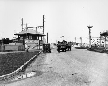 City of Kingston
Photograph - Black and white, c. 1930
... Roads ...This image is part of a larger collection of images from the Public Transport Corporation displaying train stations and streetscapes in what is now the City of Kingston.The Nepean Highway is a major highway running through the City of Kingston. This image is one of many that depicts its importance to the local community as it undergoes many changes over time.Black and white photograph depicting the level crossing at Moorabbin. While the gates at the level crossing are open, two cars are making their way across the crossing, while a third car is parked on the side of the road, in front of a large billboard/hoarding for ham and bacon products. There is a man standing on the road as if watching the cars go through the crossing. The road appears to be unsealed. Black printed text on a round white sticker adhered to the reverse: 148 Handwritten in red ink: 60% Blue ink stamped on reverse: COPYRIGHT / Public Transport Corporation / For re-ordering photographs / Please quote negative No ADU907 / Enquiries C/- PTC Photographic Unit / Telephone switchboard 619 111moorabbin, trains, railway crossing, level crossing, cars, roads, nepean highway -
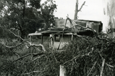 Ringwood and District Historical Society
Photograph-B&W, Wantirna Road Shack next to Dandenong Creek on East Side of Wantirna Road (near the bridge), 6/07/1989
Wantirna Road Shack next to Dandenong Creek on East Side of Wantirna Road (near the bridge). Has been there many years - maybe 40 and it is still there (18.9.1989). (Note this is NOT part of Hill's dairy but was in the same series of photographs so kept together).A shack next to Dandenong Creek / East side of Wantirna Road / Has been there many years - maybe 40 / It is still there (18.9.89) -
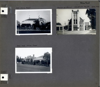 Glen Eira Historical Society
Album - Album page, Alma Road, circa 1972
This photograph is part of the Caulfield Historical Album 1972. This album was created in approximately 1972 as part of a project by the Caulfield Historical Society to assist in identifying buildings worthy of preservation. The album is related to a Survey the Caulfield Historical Society developed in collaboration with the National Trust of Australia (Victoria) and Caulfield City Council to identify historic buildings within the City of Caulfield that warranted the protection of a National Trust Classification. Principal photographer thought to be Trevor Hart, member of Caulfield Historical Society. Most photographs were taken between 1966-1972 with a small number of photographs being older and from unknown sources. All photographs are black and white except where stated, with 386 photographs over 198 pages. Church of Christ, 514 Dandenong Rd, Caulfield https://vhd.heritagecouncil.vic.gov.au/places/43594 The Dandenong Road Church of Christ has regional importance as a landmark building along the Dandenong Road. It successfully addresses its triangular site by placing the belltower at the apex, deploying Romanesque and Gothic elements freely and to dramatic effect, heightened by the symbolism of the Cross (compare Robert Haddon's St Stephens in Balaclava Road of 1926).Page 4 of Photograph Album including three black and white photographs of properties on Alma Road. Two photographs are in the top half of the page and the third is in the bottom left hand side.Handwritten in black pen: Alma Road [top right of page] / 325 Alma Road [above top left photograph] / Church of Christ Caulfield North 14 Dec 1972 [above top right photograph] / 323-325 Alma Road [above bottom left photograph] / 4 [bottom right]caulfield north, trevor hart, alma road, houses, churches, church of christ caulfield north, dandenong road, bell towers, romanesque architectural style, gothic architectural style, bi-chromatic brickwork, cast iron work, verandahs, victorian architectural style -
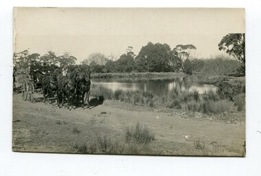
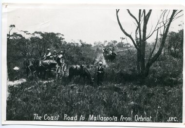 Orbost & District Historical Society
black and white photograph, late 19th century - early 20th century
Prior to the sealing of the Princes Highway west of Orbost, the road surface was anything but good, even by C1917 when cars started to use the road. From Orbost the old road via Marlo to Sydenham was abandoned for the new location which traversed more rugged country via Cabbage Tree, Bell Bird and Club Terrace to Cann River, and the reason for this diversion was on account of settlements being established at Murrungowar and Club Terrace, at which latter place there was a temporary rush to obtain gold. This road was constructed by the Public Works department and a maximum grade of 1 in 19 was adopted, and as speed was not to be catered for the grade followed in and out round the spurs and gullies, resulting in a maze of turns and twists which required a good deal of skill on the part of the horse driver to negotiate." - Bairnsdale Advertiser, Friday, May 2, 1947. (More information from Newsletter February 2010)n the late 1800's early 1900's transporting goods by road was difficult and at times impossible because roads as thoroughfares did not exist.The means of travelling along the roads in the 1800's was by bullock wagon, horse pulled dray, pack horse or simply by foot. This road is still in use in East Gippsland as a part of many four-wheel-drive touring routes.A large black / white photograph of two horse - drawn wagons on a narrow sandy bush track. It is surrounded by scrub. There is one man standing beside a horse not harnessed to a wagon.on front - "The Coast Road to Mallacoota from Orbost JPC" -
 Kiewa Valley Historical Society
Black and White photograph of Road Making Machinery, Kiewa Road Making 25/8/1938(No. 3 in a series of 8), 25/08/1938
Construction of the main road from South Tawonga to the Bogong High Plains, to provide access to the construction sites for the new Kiewa Hydro Electric Scheme, was commenced early in 1938, the work being undertaken on behalf of the Commission by the Country Roads Board. For the construction work, the Commission purchased three Caterpillar - model R07 - diesel crawler tractors equipped with Kay Brunerei (Brunner) hydraulically operated trail builders (angle dozers)). This acquisition resulted from a visit to the United States of America in May, 1937 by the Construction Engineer ( Mr. C.H. Kernot) and Assistant Civil Engineer (Mr. J.F. Douglas) where they saw this relatively new type of equipment in use. With the co-operation of the CRB, the Commission demonstrated the operation of these machines at Fishermen's Bend on 6th April, 1938. They were then sent to Kiewa where they commenced operation towards the end of the month. From South Tawonga, the route led immediately across the Western Branch of the Kiewa River necessitating the construction of a bridge 100 feet long. By the end of 1939,the excavation had been 'opened up' for a distance of 19 1/2 miles (approx. 31 km.) and of this length, 10 miles (approx. 16 km) had been surfaced.The purchase and use of this type of mechanical equipment in road making was a huge investment, as prior to this most of the work would have been done manually with the use of picks and shovels. Not only were many months of hard manual labour saved, but a very significant amount of time in providing access to the proposed work sites for the new Kiewa Hydro Scheme. This photo is an excellent reminder of how primitive the early machinery was compared to the present but also represents the forward thinking of the State Electricity Commission's Engineers in purchasing such new and innovative equipment.A black and white photograph of a Caterpillar diesel crawler tractor and a hydraulically operated trailbuilder (angle dozer) making a road in the Mt. Beauty area.Hand written in black ink in the top left hand corner are the words "Kiewa Road Making 25/8/1938". On the upper right hand of the photograph has been stamped the number 3. On the back is stamped the word 'Velox' severaly times, which is the make of the photograhic paper. roadmaking, caterpillar tractor, kiewa, state electricity commission -
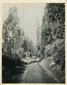
 Eltham District Historical Society Inc
Slide - Photograph, Nyora Road, Eltham, c.1993
... roads ...The east end of Nyora bewteen Stokes Place and Reynolds Road was unsealed. This section was only a fire access track as evidenced by the trees growing in the middle of the road. Real Estate agents would advertise homes as down a (dusty) country lane. The Nyora Road Resident Action Group arose to address concerns with Council regarding the dangerous conditions and traffic from outside the area using it as a 'rat-run' to avoid Main Road. Council traffic monitors showed that the amount of traffic was only 20% less than that of Mt Pleasant Road. The Action Group wanted the road closed at reynolds Road however Council elected to install speed calming devices along the sealed section between Stokes Place and Eucalyptus Road. Chicanes were added at several locations and a roundabout installed at Stokes Place in 2004. This remaining dirt section was sealed post 2004.35mm colour positive transparency Mount - Black and Whiteinfrastructure, roads, eltham, nyora road -
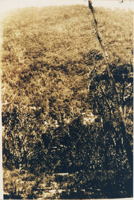 Halls Gap & Grampians Historical Society
Photograph, C 1920s
This is a photo of the Mt. Victory Road under construction. The workers camp can be seen in front of the road. For further information see 'Victoria's Wonderland', pp 102, 112 & 136. Note: The second copy is a transparency held at Slide Box No. 162.The photo shows a slope covered in thick bush. A road can just be seen in the middle foreground and a campsite with many tents can be seen through the bush in front of the road.access routes, mt victory rd -
 Mt Dandenong & District Historical Society Inc.
Photograph, The Wagon Road, c1970s
The old Wagon Road built 1876-1878. This photograph has a detailed inscription on the back handwritten by John Lundy-Clarke in 1974.The Wagon Road. Built 1876 – 8. The first settler’s road in the Ranges as apart from Dray Tracks. Was built through Jeeves Selection, Crown Allotment “C” named “Jeeves saddle” and removed the monopoly held over travel through the Gap. jeeves saddle, kalorama, road, wagon road, john lundy-clarke -
 Orbost & District Historical Society
black and white photograph, late 19th - early 20th century
This photograph was taken at the junction of the Snowy and Brodribb Rivers. The Snowy River starts in New South Wales on the slopes of Mt Kosciuszko, Australia’s highest mountain, in New South Wales. It flows into Bass Strait at Marlo in Victoria. The Brodribb River is a tributary of the Snowy which enters the estuary at Marlo. This is a pictorial record of a road in Marlo near Orbost in the late 19th-early 20th centuries. It also depicts the transport used at that time.A black / white photograph of four men in suits seated in a horse - drawn buggy on a dirt road alongside a creek or river. There appears to be another horse - drawn vehicle behind them.on back - "at the Brodribb - Snowy junction. this road was corduroy (packed logs of tea trees?)brodribb-river snowy-river marlo transport-horse-drawn -
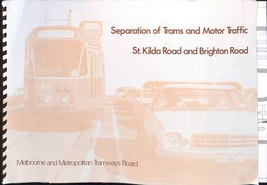 Melbourne Tram Museum
Document, Melbourne & Metropolitan Tramways Board (MMTB), "Separation of Trams and Motor Traffic - St Kilda Road and Brighton Road", May 1979
Document prepared to provide the concepts for separation of traffic along St Kilda Road and Brighton Road using safety bars, and reserved sections of roadway between Princes Bridge and Glen Huntly Road. Dated May 1979. Has an introduction, and notes the widening of St Kilda Road south of Cochrane St and its impact. Has colour photo of Z89 in Nicholson St where the Safety bars had been installed to separate traffic, installation of Safety Zones, photos of Gothenburg, Amsterdam, and Hanover showing traffic separation, graphs showing tram passenger movement in the am peak and road usage. Looks extensively at the Domain Interchange at Park and Domain Road and the suggested layout - which was implemented in Nov. 1986. Includes a photo of a very long line of trams northbound at this intersection which has undergone many changes location, to become during 2025 the entry to Anzac station. Six drawings show the proposed separation of traffic between Alexandra Ave and Glen Huntly RoadDemonstrates a planning document to separate road traffic from trams along St Kilda Road.Comb bound document titled "Separation of Trams and Motor Traffic - St Kilda Road and Brighton Road" - 12 sheets + card covers, some full colour pages with some sheets folded.tramways, st kilda road, traffic control, domain interchange, domain road, reserved track -
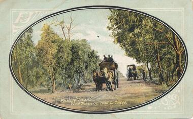 Phillip Island and District Historical Society Inc.
Photograph - Post Card, F & J Postcards, 1900's
Donated by S Serpell of Serpell & Reid Families, SandringhamColoured Postcard of two horse drawn coaches. Three people on the coach in the foreground and one person on the rear coach. A person on the roadside. Trees either side of the road. Front: Phillip Island - Wool Team on road to Cowes. Back: Harbison's Wool & Dray.wool team, horse drawn wagons, horse drawn coaches, s serpell -
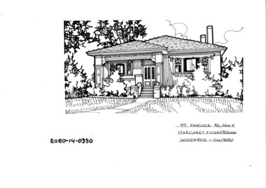 Hawthorn Historical Society
Drawing - Property Illustration, 49 Havelock Road, Hawthorn East
'After training as a Cartographic Draftsman within the mining industry, I worked as a property illustrator for real estate firms in the eastern suburbs of Melbourne for 23 years from 1983. I initially photographed houses with a Polaroid camera and made a 'thumbnail' sketch while there. The photos were used to scale off a sketch in pencil and then that sketch was overlaid with drafting film and the 'pen and ink' completed. The pens I used were the Rotring ‘Rapidigraph’ drafting pens. The ink was also made by Rotring (German).The film was ‘Rapidraw’, polyester drafting film, double matte. It takes a very fine line and doesn’t bleed. As well as house sketches, there were often floor plans and site plans ordered. Aerial sketches were ordered when the property needed an overall view.' (Margaret Picken, 2020)This property illustration is one of a series created by Margaret Picken for a range of real estate agents in Melbourne between c. 1983 and c. 2006. Each work is signed and dated by the artist.Gift of Margaret Picken, 2020pen and ink architectural drawing on drafting film. Dimension 255x165 Inscription: 49 HAVELOCK ROAD, HAW E Margaret Picken ©2000 WOODARDS -C'WELL49 HAVELOCK ROAD, HAW E Margaret Picken ©2000 WOODARDS -C'WELLartist - margaret picken 1950- -
 Phillip Island and District Historical Society Inc.
Photograph, 1900's
This postcard is contained in an album presented to the then Governor of Victoria, The Earl of Stradbroke, by the fathers of soldiers & returned soldiers of Phillip Island, on 16/02/1923. The history of the album is noted on Reg. No 85-00Postcard of Beach Road, Cowes, showing stable on site of Continental Hotel, where horse and drags collected passengers to take to Summerland, early 1900's. Moreton Bay Fig planted by Von Mueller.The Rose Series P674. Beach Road Cowes, Phillip Island, Victorialocal history, photography, photographs, slides, film, beach road, cowes, phillip island, the esplanade, transport, moreton bay fig, sepia photograph, beach road cowes -
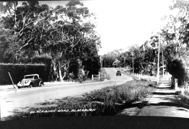 Whitehorse Historical Society Inc.
Photograph, Blackburn Road, Blackburn
black and white photo of Blackburn Road, Blackburn.2 copies of black and white photo of Blackburn Road, Blackburn.blackburn road, 1930s - 1940s ? -
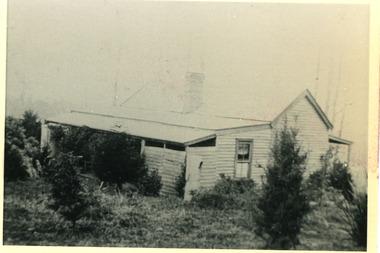 Mt Dandenong & District Historical Society Inc.
Photograph, c1911
"Hillcrest" on Mernda Road, Olinda. The home of the Devine Family. c1911 The descriptive text on the reverse of this photograph was hand written by John Lundy-Clarke.“Hillcrest” Mernda Road Olinda 1911. The home of the Devine family. The early settlement road passed to the left of the camera. House faced down over the valley of the Sassafras + Perrin Creek towards Kallista. The deviation to regrade the road passed to the right of the house. It was in front of the house on the left hand side of the picture that Vera Devine and her school mates practiced the maypole dance under her tuition. hillcrest, devine, devine family, mernda road -
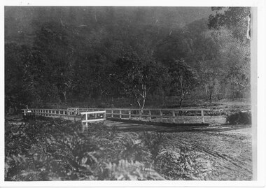 Halls Gap & Grampians Historical Society
Photograph, C 1911
... roads ...This is the second Delley''s Bridge. A new and more substantial bridge was built in 1911, only to be badly damaged in a 1917 flood. The collapsed western end was rebuilt, this time supported by concrete pillars.The photo shows a dirt road crossing a creek via a wooden bridge. A woman is driving a horse and buggy onto the far end of the bridge. There are ferns in the foreground and trees in the background.access routes, roads, structures, bridges -
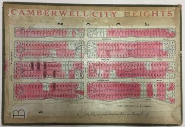 Kew Historical Society Inc
Plan - Subdivision Plan, Jas R Mathers Son & McMillan, Camberwell City Heights, 1922
"Following the 1919 amalgamation of suburban tramway trusts, an electrified tram service extended along Doncaster Road. Housing estates such as the 1919 Balwyn Park Estate, 1922 Hillcrest Estate and the Camberwell City Heights Estate, also 1922, quickly followed. These estates were built over by expansive suburban villas, set in fine gardens and along tree-lined streets. North Balwyn, largely constructed since 1933, was typified by even grander houses, many of them in the 'ocean liner' style and seen at their most distinctive in the Riverview Estate." (Source; 'Balwyn' in eMelbourne)Portions of subdivision plan mounted on both sides of cardboard sheet. Coloured pink, probably to show allotments sold. Area covered: Doncaster Road, Mountainview Road, Panoramic Road, Cityview Road, Longview Road, Riverview Road, Hillview Road, Bulleen Road. Includes location diagram showing railway lines and existing and proposed tram routes.Cardboard backing has advertisement for "Tillock's soluble coffee"subdivision plans -- camberwell (vic.), camberwell city heights subdivision -
 Lakes Entrance Historical Society
Photograph, Punt Road Metung Victoria, 1/06/1999 12:00:00 AM
Also a colour photograph looking South from Punt Road Metung 04460.1 10 x 15 cmColour photograph looking Northwest from Punt Road Metung Victoria. Also a colour photograph looking South from Punt Road Metung township, waterways, boats and boating, boardwalk -
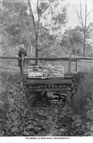 Eltham District Historical Society Inc
Photograph, The Rose Stereograph Company, Log Bridge, Eltham Road. Greensborough, c.1920
A woman stands at the end of a log bridge over a creek looking towards the south along the unsealed roadway. The sun illuminates her back. She is wearing a woollen knit beanie with edges rolled up, dark jacket and skirt, full length dark stockings and slip on dark leather shoes with raised heel, typical of the early 1920s. The creek is possibly feeding into the Karingal Yalloc. The direction of the road based on shadows is northwest as is the Eltham Road to Greensborough (present day Sherbourne, Karingal and St Helena roads). The creek is falling to the foreground so from south west to the north east, possibly feeding into the Karingal Yalloc, somewhere near presenet day Ramptons Road Reserve. This glass plate negative was used to manufacture postcards (1:1 printing) for commercial sale by the Rose Sterograph Company and its subsidiaries. George Rose founded the Rose Stereograph Company in 1880 and was joined by Herbert (Bert) Cutts in the early 20th Century. The pair formed a lifetime working partnership and strong personal friendship. Assisted by George’s two sons, Herbert George and Walter, and later by Neil Cutts, the Rose Stereograph Company continued its operations for more than 140 years. The company was initially built on stereographs, but as cinema took over and stereographs fell out of fashion, the Rose Stereograph Company developed Australia’s first commercially viable photographic postcard business. Specialising in postcards of iconic historical moments and significant landmarks, The Rose Stereograph Company became a staple of the Australian travel industry.This remarkable collection of glass plate negatives, transparencies, and postcards – arguably Australia’s most significant photography collection outside of public hands – has been passed down through the generations, surviving war, relocation, and the harsh Victorian climate. The historic Rose Stereograph collection is the culmination of George Rose’s dream of capturing and preserving precious moments in time and remains the legacy of the Rose and Cutts families. It is with great sadness that the Cutts family says goodbye to a collection that spans five generations and 140 years. The Cutts family understands that for these historically important pieces to rest with one family is to deny others the pleasure of their custodianship.Glass Plate Negative Size: 9.2 x 13.8 cmLog Bridge, Eltham Road, Greensborougheltham, postcard, travel, rose stereograph company, glass plate negative, creek, eltham road, greensborough, karingal road, karingal yallock, log bridge, sherbourne road, st helena road, women's fashion, rampton's road reserve, peter and elizabeth pidgeon collection -
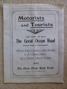 Warrnambool and District Historical Society Inc.
Leaflet, Motorists and Tourists
This leaflet published by The Great Ocean Road Trust in 1918 gives information about the proposed building of the Great Ocean Road from Barwon Heads to Warrnambool as a memorial to Victorian soldiers in World War One. The President of the Trust, which was a private company seeking donations from the public, was Howard Hitchcock, the Mayor of Geelong. The Memorial Great Ocean Road commenced in 1919 with 3000 ex-servicemen employed to build the road. In 1932 the road was completed to Apollo Bay and in 1936 the road was officially handed into the care of the State Government. This leaflet is of some significance as it shows the initial efforts by Howard Hitchcock of Geelong and a private trust to build the Great Ocean Road in Victoria. This road is today of international significance This is an unbound leaflet of 8 pages (almost A4 size) folded into two insert pages. It has 10 photographs of views along the Great Ocean Road and typed information on the Great Ocean Road Trust and its Building Appeal. It was produced in 1918.great ocean road, great ocean road trust 1918, warrnambool history, memorial great ocean road