Showing 3847 items
matching surveyed
-
 University of Melbourne, Burnley Campus Archives
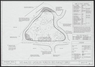
Plan, Jennifer Young, Grevillea Robusta Bed, 2006
(1) Site Analyis. (2) Plant Survey by Jennifer Young, March 2006. (3) Plant Plan.jennifer young, grevillea -
 Bendigo Military Museum
Map - MAPS, BELGIUM WW1, 1912 - 1917
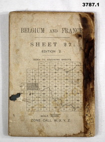
(.1) Areas covered on this map, Bollezeele to Poperinghe, Arques to Meteren. (.2) Areas covered on this map, BourBourg to Poelcapple, Reemilly to Armentieres. (.3) Areas covered on this map, Bruges, Neuzen, Ghent. (.4) Areas covered on this map, Alost, Loulain, Soignes, St Germain. (.5) Areas covered on this map, Roulers, Oosterzeele, Lille, Thoriecourt. Items relate to William Alexander No 502 AIF. Refer 3746.3 for his service details.(.1) Map, Belgium and France, sheet 27, Edition 2, scale 1:40,000, zone call W.X.Y.Z, Ordnance survey May 1917, gauze lined. (.2) Map, Belgium, Hazebrouck 5A, Edition 2, scale 1:100,000, Ordnance survey 1916, gauze lined. (.3) Map, Belgium, Ghent 2, scale 1:100,000, War Office June 1915. (.4) Map, Belgium, Brussels 6, scale 1:100,000, Drawn at War Office, Ordnance survey 1912. (.5) Map, Belgium, Tournai 6, scale 1:100,000, War Office Ordnance survey July 1912.(.1) On rear, “Glossary of terms”maps, belgium, france -
 Bendigo Military Museum
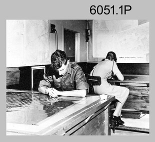
Photograph - Retouching Reproduction Material at the Army Survey Regiment, c1960s, c1970s
The first four photographs were most likely taken in the 1960 and the fifth in the 1970s at the Army Survey Regiment, Fortuna, Bendigo. As there are no annotations with the photos, the exact dates, locations and names of personnel are unknown. SGT Bob Scaddan appears in the fifth photo taken in the 1970s Photos .1P and .2P. could have been taken in Lithographic Squadron’s retouching room and Photos .3P, .4P and .5P. were probably taken in Cartographic Squadron’s Correcting Section, located in the Attic. Retouching mainly entailed the application of liquid opaque (Plumtree), commonly known as “duff” to cover blemishes such as scratches and spots on film negatives before photographic exposure. Retouching technicians also used specialised techniques such as “needling” to repair faults on the emulsion of map reproduction material. The technician in photo .4P is needling a hydrographic feature on a drainage negative, with a zoom transfer scope projecting a scaled projected aerial photograph as a positional reference. This is a set of five photographs of technicians retouching reproduction material at the Army Survey Regiment, Bendigo. The photographs were printed on photographic paper and are part of the Army Survey Regiment’s Collection. The photographs were scanned at 300 dpi. .1) - Photo, black & white, c1960s. unidentified personnel in Lithographic Squadron. .2) - Photo, black & white, c1960s. unidentified personnel in Lithographic Squadron. .3) - Photo, black & white, c1960s. unidentified personnel in Cartographic Squadron Attic. .4) - Photo, black & white, c1960s. unidentified personnel in Cartographic Squadron Attic. .5) - Photo, black & white, c1970s. SGT Bob Scaddan in Cartographic Squadron..1P to .3P, .5P - annotated “Retouching”royal australian survey corps, rasvy, army survey regiment, army svy regt, fortuna, asr, litho, carto -
 Bendigo Historical Society Inc.
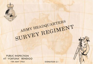
Document - ARMY HEADQUARTERS SURVEY REGIMENT, BENDIGO, 10 May, 1964
Army Headquarters Survey Regiment, Bendigo. Public Inspection at 'Fortuna', 10 May 1964. Donation 2/-. Includes photos of the Entrance Hall, Music Room and Villa. 3 army photos. In 1942 the mansion was occupied by the Australian Survey Corps and 'Fortuna' became the site of the base map production plant of the Australian Army for the remainder of the war years. During this period approximately sixteen million maps of Australian Territories and theatres of operation in the South West Pacific Area, were produced for use by the Allied Services. This function was continued as a peace time role in the post war years, and in 1951 ''Fortuna'' was purchased by the Commonwealth Government. As the largest unit of the Royal Australian Survey Corps, AHQ Survey Regiment carries out mapping in all parts of the Commonwealth and Territories including Papua and New Guinea. The Regiment is not only capable of doing its own field surveys but is responsible for the drawing and printing of map compilations from Royal Australian Survey Corps units in all States. . . . Includes map of grounds.buildings, residential, fortuna villa, army headquarters survey regiment, bendigo. public inspection at 'fortuna', 1964. photos of the entrance hall, music room and villa. mansion was occupied by australian survey corps and 'fortuna' site of the base map production plant australian army war. sixteen million maps australian territories and theatres of operation in the south west pacific area, were produced for use by the allied services. 1951 ''fortuna'' was purchased by the commonwealth government. royal australian survey corps, ahq survey regiment mapping commonwealth and territories including papua and new guinea. royal australian survey corps units in all states. map of grounds -
 Bendigo Military Museum
Photograph - Lithographic Squadron Building Upgrades - Army Survey Regiment, Fortuna, Bendigo, 1990
This is a set of 11 photographs of Lithographic Squadron Building Upgrades at the Army Survey Regiment, Fortuna, Bendigo. 1990. These upgrades performed by Litho personnel occurred at around the same time as the construction of Lithographic Squadron’s new Printing Building. This is a set of 11 photograph of Lithographic Squadron building upgrades at the Army Survey Regiment at Fortuna, Bendigo, 1990. The photographs were on 35mm negative film and were scanned at 96 dpi. They are part of the Army Survey Regiment’s Collection. .1) and .2) - Photo, colour, 1990, building construction. .3) - Photo, colour, 1990, building modifications, L to R: Dale Hudson, WO2 Keith Fenton RE. .4) - Photo, colour, 1990, building modifications, L to R: Roy Hicks, Lance Strudwick, Dale Hudson, Ian Nicholls, Gary Lord, Kim Reynolds, Peter Swandale (rear), Gavin McLean, Andrew Arman, Graham Spong, Mark McCullough. .5) - Photo, colour, 1990. building modifications, L to R: Ross Anza, unidentified, Damien Cole. .6) and .7) - Photo, colour, 1990, Old proofing hut. .8) - Photo, colour, 1990, building modifications, Brian Fauth. .9) - Photo, colour, 1990, building modifications, L to R: Roy Hicks, Brian Fauth. .10) - Photo, colour, 1990, building modifications, L to R: Peter Swandale, Gary Kerr, Ian Nicholls, Brian Fauth, Roy Hicks. .11) - Photo, colour, 1990, building modifications, L to R: Peter Swandale, Gary Kerr, Brian Fauth, Ian Nicholls, Roy Hicks. No personnel are identified. royal australian survey corps, rasvy, army survey regiment, army svy regt, fortuna, asr, litho -
 Bendigo Military Museum
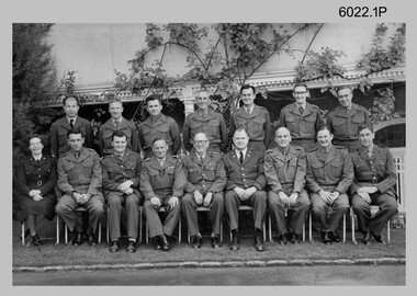
Photograph - Commissioned Officers of the Army Survey Regiment, c1962-1965, 1972, c1973-1974
These photographs of Royal Australian Survey Corps commissioned officers was taken at the Army Survey Regiment circa 1962-1965, 1972 and circa 1973-1974. Officer appointments to the Army Svy Regt were typically the CO, 2IC, Adjutant; and an OC, 2IC and Troop Officers assigned to the Headquarters, Topographic/Air Survey, Cartographic and Lithographic Squadrons. RAN and RAAF liaison officers were usually appointed to the Regiment; and occasionally exchange officers from other Corps, the USA or UK.This is a set of photographs of RASvy Officers at the Army Survey Regiment, Bendigo. The photographs were printed on photographic paper and are part of the Army Survey Regiment’s Collection. The photographs were scanned at 300 dpi. .1) Photo, black & white c1962-1965. .1) Photo, black & white c1962-1965. Corps Conference Back row – L to R: 3rd LT Jorge Gruszka, 5th CAPT Peter Constantine. 7th MAJ Brian Dalton Front row – L to R: 1st CAPT Carol Castor, 2nd MAJ NRJ Hillier, R3rd MAJ Bill Howarth, 4th CO LTCOL Frank Buckland, 5th DSVY-A COL Don Macdonald, 7th MAJ John Nolan, 8th MAJ Eddy Anderson. .2) Photo, black & white, c1972. Back row – L to R: CAPT Jack Gore, LT Royal, FLT Sinclair, LT Fred Brown, LT John Winzar, LT Gary Kenney, LT Reg Smith, 2LT Terry Edwards, LT Bob Roche. Front row – L to R: CAPT McNeale, 2LT William, MAJ Keith Todd, MAJ Don Ridge, LTCOL Bill Howarth, MAJ Brian Dalton, MAJ John Bullen, LT C. Chittleborough, LT Bailey .3) Photo, black & white c1972. Back row – L to R: 1st 2LT Terry Edwards, 7th LT Gary Kenney, 9th LT Bob Roche. Front row – L to R: 1st CAPT Jack Gore, 3rd LT Bailey, 4th MAJ Keith Todd, 5th MAJ Don Ridge, 6th LTCOL Bill Howarth, 7th MAJ Brian Dalton, 8th MAJ John Bullen, 9th FLT Sinclair, 10th CAPT McNeale. .4) Photo, black & white, c1972. Personnel named as per .3) .5) Photo, black & white, c1973-1974. Back row – L to R: 1st LT Graham Baker, 4th MAJ John Sinclair , 7th CAPT Reg Smith, 8th LT Terry Edwards. Front row – L to R: 3rd MAJ Peter Constantine, 4th LTCOL Don Ridge 5th MAJ John Cattell. .6) Photo, colour print of .5), c1973-1974 Personnel named as per .5).1 no annotation, .2 Personnel (surnames, no rank) annotated on back, .3 to .6 no annotationroyal australian survey corps, rasvy, army survey regiment, army svy regt, fortuna, asr -
 Bendigo Military Museum
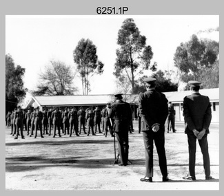
Photograph - Army Survey Regiment – Commanding Officer Handover Parade, 1975
These nine photographs were taken at a Commanding Officer Handover Parade at the Army Survey Regiment, Bendigo on the 28th of July 1975. A march past took place after the parade, with each squadron marching down the roadway past Fortuna Villa to salute the outgoing CO LTCOL Donald Ridge, as he stood on the steps at the front of the building. LTCOL Donald Ridge was the CO of Army Headquarters Survey Regiment from 1972 to 1973 and continued as the CO of the renamed Army Survey Regiment from 1974 to 1975. He handed over to LTCOL Peter Constantine AM, who commanded the unit from 1975 to 1976. This is a set of nine photographs of a Commanding Officer Handover Parade at the Army Survey Regiment, Bendigo on the 28th of July 1975. The photographs were printed on photographic paper and are part of the Army Survey Regiment’s Collection. The photographs were scanned at 300 dpi. .1) - Photo, black and white, c1975. L to R: CO LTCOL Don Ridge, LTCOL Peter Constantine AM, CAPT Errol Royle-ADJT. .2) - Photo, black and white, c1975. L to R: CO LTCOL Don Ridge, RSM WO1 John Hogan, ADJT CAPT Errol Royle, SPR Steve Egan, LTCOL Peter Constantine AM. .3) - Photo, black and white, c1975. L to R: WO2 Tibor Szentirmay BEM, ADJT CAPT Errol Royle, CO LTCOL Don Ridge, SPR Steve Egan, LTCOL Peter Constantine AM. .4) - Photo, black and white, c1975. L to R: LTCOL Don Ridge, SPR Steve Egan. .5) - Photo, black and white, c1975. L to R: WO1 John Hogan-RSM, unidentified (x2), CO LTCOL Don Ridge, CAPT Terry Edwards, unidentified. .6) - Photo, black and white, c1975. L to R: SPR Warren Hall, CAPT Arthur Henson, CPL Warren Chadwick, LT Don Maskew, CO LTCOL Don Ridge, CAPT Terry Edwards. .7) - Photo, black and white, c1975. L to R: CPL Jim Beard, unidentified personnel (x5), CPL Bob Scaddan, unidentified officer, CO LTCOL Don Ridge, CAPT Terry Edwards. .8) - Photo, black and white, c1975. L to R: unidentified personnel (x3), unidentified officers (x2) , CO LTCOL Don Ridge, CAPT Terry Edwards. .9) - Photo, black and white, c1975. L to R: unidentified officers (x3), CO LTCOL Don Ridge, CAPT Terry Edwards.The date of the parade is provided on a paper sleeve.royal australian survey corps, rasvy, army survey regiment, army svy regt, fortuna, asr -
 Bendigo Military Museum
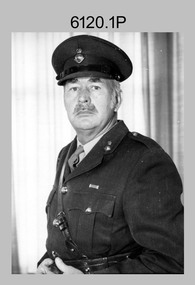
photograph - Regimental Sergeant-Majors (RSMs) of the Army Survey Regiment, Bendigo, 1963 to 1982
This is a set of four photographs of three Regimental Sergeant-Majors (RSMs) of the Army Survey Regiment at Fortuna. Their appointments as RSM spanned from 1963 to 1976. WO1 Robin Wilson’s appointment was from 1963 to 1966. He served in the Australian Army from 1946 to 1979. WO1 Wilson ended his service in another corps as a commissioned officer and reached the rank of Major. WO1 Peter Gale’s appointment was from 1966 to 1968. He served in the Australian Army from 1946 to 1968. WO1 John Hogan’s appointment was from 1968 to 1976. After transfer from the British Army, he served in the Australian Army from 1952 to 1976. WO1 Hogan continued his service in Defence as the RAN Liaison Officer located in Fortuna’s coach house building for several more years. WO1 Aub Harvey’s appointment was from 1976 to 1982.This is a set of five photographs of four Regimental Sergeant-Majors (RSMs) of the Army Survey Regiment at Fortuna, Bendigo, from 1963 to 1982. The black and white photographs were printed on photographic paper and are part of the Army Survey Regiment’s Collection. The photographs were scanned at 300 dpi. .1) - Photo, black & white, 1963-1966, WO1 Robin Wilson. .2) - Photo, black & white, 1963-1966, WO1 Robin Wilson. .3) - Photo, black & white, 1966-1968 WO1 Peter Gale. .4) - Photo, black & white, 1968-1976, WO1 John Hogan. .5) - Photo, black & white, 1976-1982, WO1 Aub Harvey..1P to .5P – No annotation.royal australian survey corps, rasvy, army survey regiment, army svy regt, fortuna, asr -
 Bendigo Military Museum
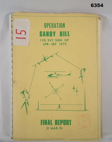
Administrative record - Operation Report - Operation Sandy Hill 1Fd Svy Sqn Apr - Sep 1975, 1 Fd Svy Sqn, 1976
Comprehensive Operation Report on Operation Sandy Hill conducted by 1Fd Svy Sqn Apr-Sep 1975 Part 1 Forward, Part 2 Planning and Mounting, Part 3 Final Report OC 1 Fd Svy Sqn, Part 4 Report Abn/EDM Gp, Part 5 Report Recon, Stn Marking and Traversing Gp, Part 6 Admin Report, Part 7 Report OC 171 Op Spt Sqn, Part 8 Computations and Results, Part 9 Observations and Recommendations.A4 size report held together with a plastic spiral binding, Light Cardboard cover includes many foldout Annexes"15" on front cover. Rubber stamp "Army Survey Regiment Map Library"royal australian survey corps, rasvy, fortuna, army survey regiment, army svy regt, asr -
 Greensborough Historical Society
Plan, Plan of Manatunga Circuit Greensborough subdivision, 1970_
Plan of Manatunga Circuit subdivision. Prepared by O'Connor and Beveridge (land surveyors) for Development Underwriting (developers). Plan of subdivision. Part of Crown Portion 3. Parish of Nillumbik, County of Evelyn.An original example of a subdivision plan in the expanding suburb of Greensborough. The 1960s and 1970s saw this area develop from a rural farming area to a suburb.Plan of subdivision. Printed on buff paper, hand coloured. Mounted on cardboard. Includes 2 small cards attached.Various handwritten comments. Small cards from Survey Branch, Office of Titles.greensborough, manatunga circuit, diamond creek road, plenty river drive -
 Port Melbourne Historical & Preservation Society
Plan - Proposed land sub-division, west of railway, Sandridge, 19 Nov 1866
1866 plan of proposed sub-division of land at Sandridge, west of railway. Includes manure depot.J. Noone (Photolithographer, Dept. of Lands and Survey) J. Hardy (Assistant Surveyor)town planning, town planning - proposals shelved, j noone, j hardy -
 Bendigo Historical Society Inc.
Map - JACK FLYNN COLLECTION: TARNAGULLA SHEET 4, 25/11/1926
Map: Parish of Tarnagulla Sheet 4, Counties of Gladstone and Bendigo. Parish plan.Photo-Lithographed at the Department of lands and Survey, Melbourne by W. J. Butson. 25.11.26map, gladstone, parish plan, tarnagulla sheet 4 -
 Bendigo Historical Society Inc.
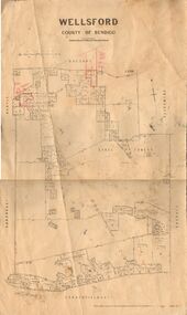
Map - JACK FLYNN COLLECTION: WELLSFORD, 2/11/1914
Map: Parish of Wellsford, County of Bendigo. Parish plan.Photo-Lithographed at the Department of Lands and Survey Melbourne By H.J. Butson. 2-.11.14map, bendigo, parish plan, wellsford -
 Bendigo Historical Society Inc.
Map - JACK FLYNN COLLECTION: HUNTLY, 12.03.1932
Map: Township of Huntly, Parish of Huntly , County of Bendigo. Parish plan. Western and South Riding Division on Main St. (Main Northern Highway) - written in ink below name of map.BY Authority H.J. Green. Photo-Lithographed at the Dept., of Lands and Survey, Melbourne. 12.3.32map, bendigo, township, huntly -
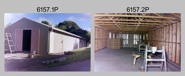
 Bendigo Military Museum
Photograph - New Printing Building foundation preparation, Lithographic Squadron - Army Survey Regiment, Fortuna, Bendigo, 1987
This is a set of 18 photographs of contractors preparing the foundations for the construction of Lithographic Squadron’s new Printing Building at Fortuna, Bendigo on the 2nd of October 1987. The building was purpose built to house a new computer-controlled Heidelberg Speedmaster 102 five colour lithographic offset Printing Press. The print room was named Wayzgoose Hall after a medieval printing house festival. Wayzgoose Hall and the Speedmaster Press printing capability was commissioned by the Commander of the 3rd Military District BRIG P. Davies AM, ADC on Wednesday 27th June 1990. This occasion is covered in more detail in page 145 of Valerie Lovejoy’s book 'Mapmakers of Fortuna – A history of the Army Survey Regiment’ ISBN: 0-646-42120-4.This is a set of 18 photograph of the foundations being prepared for Lithographic Squadron’s new Printing Building, Army Survey Regiment at Fortuna, Bendigo, 2nd October 1987. Black and white photos .1P to .4P are on photographic paper and scanned at 300 dpi. Photographs .5P to.18P are on 35mm negative film and scanned at 96 dpi. They are part of the Army Survey Regiment’s Collection. .1) to .9) - Photo, black & white, 1987. Foundations preparation. .10) - Photo, black & white, 1987. Foundations preparation, Paul Baker. .11) - Photo, black & white, 1987. Foundations preparation, Gary Kerr .12) to .17) - Photo, black & white, 1987. Foundations preparation. .18) - Photo, black & white, 1987. Foundations preparation, Gary Kerr No personnel are identified. Annotated with date on negative sleeve.royal australian survey corps, rasvy, army survey regiment, army svy regt, fortuna, asr, litho, printing -
 Ringwood and District Historical Society
Article - Newspaper Clipping, Land Sale Advertisements, Golden Hill Estate, Ringwood - 1965, 1966, and Plan of Survey of Lot 8, Mullum Mullum Road Ringwood, 1970
Newspaper clippings from Melbourne Sun newspaper (11th December 1965 and 15th January 1966) advertising sale of land - Golden Hill Estate, Ringwood, with summary of features and aerial photograph including artistic representation of street layout. Subdivision includes Mullum Mullum Road, Sonia Street, Jill Court, Linda Drive, Eve Court, Alma Court, and Jacynthe Court. Attachments include reference to Lot 46 as site of original Peter Vergers' orchard residence and subsequent 1970 surveyor's Plan of Survey of Lot 8 Mullum Mullum Road Ringwood, LP 67513, Cert of Title 8581/429.Agent - Aaron, King & Co., Suite 2, 33 Queens Road, Melbourne. (Phone) 26-2443, A.H. 850-2195. Plan of Survey signed on 25.7.1970 by Roger M. Gamble, Land Surveyor, 28 Summit Crescent, Ringwood 3134. -
Victorian Aboriginal Corporation for Languages
Map, Geographic Data Victoria, Vicmap topographic map index as at June 2000, 2000
Index to Vicmap topographic mapping, including 1:25 000 and 1:50 000 topographic maps, and Outdoor leisure series, compiled by the earlier bodies, Survey &? Mapping Victoria, etc. Also indexes Royal Australian Survey Corps' 1:50 000 topographic mapping.mapsvictorian maps, topographic maps -
 Bendigo Military Museum
Photograph - Photo Troop, Lithographic Squadron – Army Survey Regiment, Fortuna, Bendigo, 1988
This collection of 10 photos was most likely taken at Lithographic Squadron, Army Survey Regiment, Fortuna, Bendigo in 1988. The main tasks undertaken by technicians in Photo Troop were most likely enlargements, reductions and duplication of map reproduction material, and processing of aerial photography.This is a set of 10 photographs of Photo Troop personnel and equipment from Lithographic Squadron at the Army Survey Regiment, Fortuna, Bendigo, 1988. The photographs were on 35mm negative film and were scanned at 96 dpi. They are part of the Army Survey Regiment’s Collection. .1) - Photo, black & white, 1988, BARCRO work area, SPR Gary Sievers. .2) - Photo, black & white, 1988, KLIMSCH Commodore camera, CPL Mick Gillham. .3) - Photo, black & white, 1988, KLIMSCH Commodore camera, CPL Mick Gillham. .4) - Photo, black & white, 1988, WILD U4A Diapositive Camera, SPR Rob Jones. .5) - Photo, black & white, 1988, WILD U4A Diapositive Camera, SPR Rob Jones. .6) - Photo, black & white, 1988, WILD U4A Diapositive Camera, SPR Rob Jones. .7) - Photo, black & white, 1988, WILD U4A Diapositive Camera, SPR Rob Jones. .8) - Photo, black & white, 1988, WILD U4A Diapositive Camera, SPR Rob Jones. .9) - Photo, black & white, 1988, Photographic camera enlarger, unidentified technician. .10) - Photo, black & white, 1988, SUPER CHROMEGA F Photographic camera enlarger. No personnel are identifiedroyal australian survey corps, rasvy, army survey regiment, army svy regt, fortuna, asr, litho -
 Bendigo Military Museum
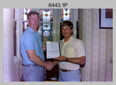
Photograph - Farewells to WO1 Adsett and WO1 Presser, Army Survey Regiment, Fortuna, Bendigo, 1989
This is a set of nine photographs of farewells to WO1 Allan Adsett and WO1 Peter Presser in the Officer’s Mess at the Army Survey Regiment, Fortuna, Bendigo in 1989. RSM WO1 Neville Stone presented WO1 Adsett, WO1 Presser certificates commemorating their military service and contribution to the Royal Australian Survey Corps. SGT’s Mess plaques and flowers were also presented to WO1 Adsett, WO1 Presser and their wives. WO1 Adsett served in the Australian Army from 1967 to 1990 and WO1 Presser served in the Australian Army from 1970 to 1990.This is a set of nine photographs of farewells to WO1 Allan Adsett and WO1 Peter Presser at the Army Survey Regiment at Fortuna, Bendigo in 1989. The photographs are on 35mm negative film. They are part of the Army Survey Regiment’s Collection. The photographic negatives were scanned at 96 dpi. .1) - Photo, black and white, 1989. L to R: RSM WO1 Neville Stone, WO1 Peter Presser. .2) - Photo, black and white, 1989. L to R: WO1 Colin Cuskelly, Mrs Leslie Presser, WO1 Peter Presser, RSM WO1 Neville Stone. .3) - Photo, black and white, 1989. L to R: Mrs Lesley Presser, WO1 Peter Presser, RSM WO1 Neville Stone. .4) - Photo, black and white, 1989. L to R: WO1 Colin Cuskelly, Mrs Leslie Presser, WO1 Peter Presser. .5) - Photo, black and white, 1989. L to R: WO1 Peter Presser, Mrs Leslie Presser. .6) - Photo, black and white, 1989. L to R: RSM WO1 Neville Stone, WO1 Allan Adsett .7) - Photo, black and white, 1989. L to R: Maz Cuskelly, WO1 Colin Cuskelly, RSM WO1 Neville Stone, WO1 Allan Adsett and Mrs Judyne Adsett, unidentified (x3). .8) - Photo, black and white, 1989. L to R: RSM WO1 Neville Stone, WO1 Allan Adsett and Mrs Judyne Adsett, unidentified (x3). .9) - Photo, black and white, 1989. L to R: WO1 Allan Adsett and Mrs Judyne Adsett. .1P to .9P – Personnel are identified on the film negative sleeve cover sheet.royal australian survey corps, rasvy, army survey regiment, army svy regt, fortuna, asr, litho sqn -
 Bendigo Military Museum
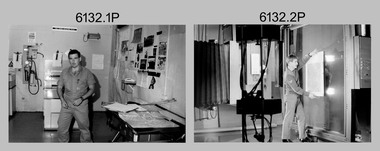
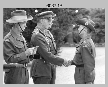
Photograph - Army Survey Regiment – Defence Force Service Medal Presentations, c1967, c1976-1980
This is a set of nine photographs of medal presentations at the Army Survey Regiment, Fortuna, Bendigo. In photos .1P to .8P, the Defence Force Service Medal was presented to personnel in recognition of 15 years of efficient remunerated service, or the Clasp for each further 5-year period of service. The photos were taken on four separate occasions. Photos .1P to .3P were taken on the parade ground. LTCOL John Nolan was the CO of the Army Headquarters Survey Regiment from 1965 to 1969. He was subsequently promoted to COL and was the Director of Military Survey from 1972 to 1975. MAJ Lionel ‘Bill’ Sprenger MBE, MID was subsequently promoted to LTCOL and was the CO of the unit from 1969 to 1970. Photos .4P to .7P were taken in circa mid-1970s and Photo .8P was taken on Friday 21 October 1976. Photos .4P to .8P were taken next to the flagpole in Fortuna Villa’s front garden. This is a set of nine photographs of medal presentations at the Army Survey Regiment, Bendigo circa 1960s-1970s. The photographs were printed on photographic paper and are part of the Army Survey Regiment’s Collection. The photographs were scanned at 300 dpi. .1) - Photo, black & white, c1967. L to R: MAJ Lionel ‘Bill’ Sprenger MBE, MID; unidentified visiting General, CO LTCOL John Nolan, LT Jack McNeale. .2) - Photo, black & white, c1967. L to R: MAJ Lionel ‘Bill’ Sprenger MBE, MID; unidentified visiting General, CO LTCOL John Nolan, WO1 Jack Gore. .3) - Photo, black & white, c1967. L to R: MAJ Lionel ‘Bill’ Sprenger MBE, MID; unidentified visiting General, CO LTCOL John Nolan, WO2 Robin Wilson. .4) & .5) - Photo, black & white, c1976. L to R: WO1 Don Taylor, BRIG Jim SHELTON DSO, MC, MID. .6) & .7) - Photo, black & white, c1976. L to R: SGT Syd Davis, Brigadier Jim SHELTON DSO, MC, MID. .8) - Photo, black & white, 1976. L to R: SSGT Gordon Haswell, WO1 Marj Knight, MAJGEN John Williamson AO, OBE GOC FF COMD. .9) - Photo, black & white, c1976-1980. L to R: unidentified (x2), WO2 John McCulloch, unidentified, WO1 Darby Munro, CO LTCOL Bob Skitch, unidentified visiting General..1P to .9P – no annotationsroyal australian survey corps, rasvy, army survey regiment, army svy regt, fortuna, asr -
 Bendigo Military Museum
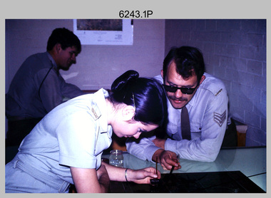
Photograph - Retouching Reproduction Material at the Army Survey Regiment, Fortuna, Bendigo, c1975
This is a set of seven photographs of technicians retouching orthophoto reproduction material at the Army Survey Regiment, Bendigo, c1975. Retouching mainly entailed the application of liquid opaque (Plumtree), commonly known as “duff” to cover blemishes such as scratches and spots on film negatives before photographic exposure. Retouching technicians also used specialised techniques such as “needling” to repair faults on the emulsion of map reproduction material. The technicians in this set of photos were probably working on the retouching and registration of orthophotomap colour film separations in preparation for publication by Print Troop. Peter Dew featuring in photos .1P to .5P was a serving member of RA Svy, who died in a tragic accident at home. He was fondly remembered as one of Lithographic Squadron’s colourful personalities. The "Super Animal of the Year" Peter Dew Memorial Award was an award presented to a member of the squadron for a crude act. To view a photo of this award, refer to item 6230 of the Victorian Collections.This is a set of seven photographs of technicians retouching and assembling orthophoto reproduction material at the Army Survey Regiment, Fortuna, Bendigo. c1975. The photographs are on 35mm colour slides and were scanned at 96 dpi. They are part of the Army Survey Regiment’s Collection. .1) to .3) - Photo, colour, c1975. Retouching reproduction material. L to R: SPR Ralph Chant, PTE Laurie Tedford, SGT Peter Dew. .4) to .5) - Photo, colour, c1975. Retouching reproduction material. SGT Peter Dew. .6) - Photo, colour, c1975. Assembly of orthophoto colour film separations. .7) - Photo, colour, c1975. Assembly of orthophoto colour film separations, CPL Garran Hill..1P to .7P - There are no annotations stored with the 35mm slides.royal australian survey corps, rasvy, army survey regiment, army svy regt, fortuna, asr, litho -
 Bendigo Historical Society Inc.
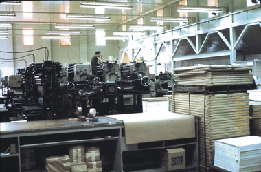
Slide - AHQ,SURVEY REGT, FORTUNA,BENDIGO, April 1970
Slide. AHQ, Survey Regt, Fortuna, Bendigo. In the background there are two workers on the mapping machines with paper stacked at front.slide, bendigo, ahq, survey regt, fortuna, bendigo., ahq, survey regt, fortuna, bendigo. -
Lakes Entrance Regional Historical Society (operating as Lakes Entrance History Centre & Museum)
Book, Andrew Claridge, Dargo Crooked River a Pictorial History, 1989
A Preliminary Survey of Crown Lands between Lake Bunga and Mill Piont, Lake Tyers Beach Area Victoria.surveying -
Whitehorse Historical Society Inc.
Article, Local survey leads the way
Article covering a survey of Nunawading residents aged 70 and over.Article covering a survey of Nunawading residents aged 70 and over will help develop and improve services for the aged. With photo.Article covering a survey of Nunawading residents aged 70 and over. welfare services, quality of life project, haynes, howard, phillips, philippa, britton, di, aged people -
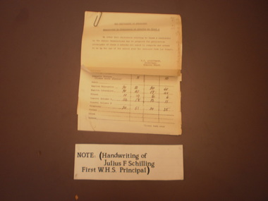 Wangaratta High School
Memorandum to Principles of Schools, 1950
Faded paper university of Melbourne Statistics survey and typed description. Handwriting is that of the first principal of WHS Julius Schilling. -
 Otway Districts Historical Society
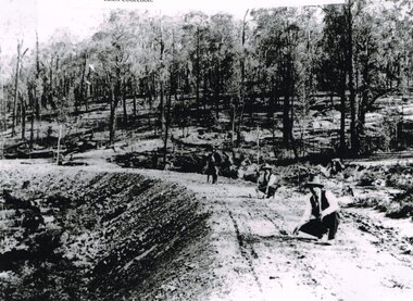
Photograph, Knox Collection, Surveying construction near Barongarook, 1900, 1900
In 1898 a recommendation for a railway of 2 ft 6 in gauge was handed down by the Parliamentary Standing Committee on Railways, to cost $138,000. Construction of the Colac-Beech Forest railway line began in 1900. About 100 men were employed in laying and ballasting the track while others formed the earthworks and the building of culverts and bridges. The earthworks of gravel ballast 150 mm deep were formed by horse and scoop or by shovel. Once the bed had been laid surveyors went along to check the layout, particularly all check rail curves and all 100 metre curves which the surveyors in the picture are doing.B/W. Three men surveying the construction of a curved bed on which track will be laid, near Barongarook, Victoria.colac; beech forest; barongarook; railways; -
RMIT GSBL Justice Smith Collection
Book series, Civil Justice Committee et al, Report to the Honourable Attorney-General concerning the administration of civil justice in Victoria, 1984-1985
No. of volumes: 4 Volume range: Preliminary study, Vols. 1-2 & Court surveys and studies 1978-1984 ISBN: 0908417144 (set) victoria -- law -
Bendigo Historical Society Inc.
Document - MINING REPORTS - REPORT OF, ON AURIFEROUS DRIFTS AND QUARTZ REEFS
Printed document: Geological Department: Report of, on auriferous Drifts and Quartz Reefs, dated 8th May,1866. Paper describes the gravels and rocks of a Geological Survey. Survey is compared with the lower drifts of Bendigo, Epsom, Ballaarat, Castlemaine and other gold-fields. Four colour sketch-sections included.document, gold, mining reports, mining reports, report of, on auriferous drifts and quartz reefs, mr bindon, alfred r c selwyn, john ferres -
 Bendigo Historical Society Inc.
Map - FORTUNA HUSTLER'S MINE - PLAN OF THE FORTUNA HUSTLER'S MINE
Plan of the Fortuna Hustler's Mine, Bulletin No 33, Plate No II. Geological Survey of Victoria. Signed by H A Whitelaw, Underground Survey Office Bendigo, September 1913. Map shows levels and depths. There are smaller drawings of some sections of some levels. This item has not been scanned or photographed.mining, parish map, fortuna hustler's mine, plan of the fortuna hustler's mine, geological survey of victoria, h a whitelaw, underground survey office bendigo -
 Bendigo Historical Society Inc.
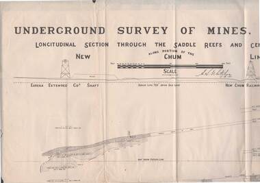
Map - STRUGNELL COLLECTION: NEW CHUM LINE OF REEF, 5/4/01
Map, Along portion of the New Chum Line, Underground Survey of Mines, Bendigo, Longitudinal Section through the Saddle Reefs and Centre Country. Eureka Extended Co's shaft, New Chum Railway Co's shaft. Surveyed under the supervision of H.Herman, B.C.E., F.G.S., Acting Government Geologist.H.S.Whitelowmap, bendigo, new chum line