Showing 734 items matching "building blocks"
-
 Linton and District Historical Society Inc
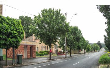
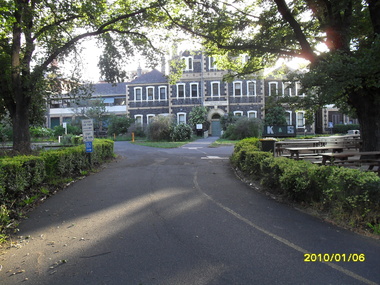
Photograph, View along Sussex Street to the North, Linton, 2014
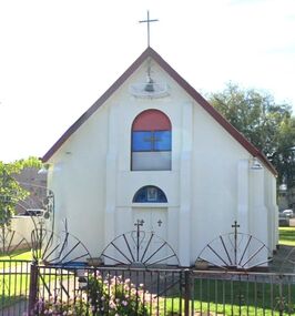
The public toilet block in Linton is decorated with hand-made terracotta tiles depicting historic themes. The tiles were produced as part of the Press Mould Tile Project 2001-2002 by Linton Primary School students and community members. Tile design and project coordination was by Pam Farey and Anne Dietrich, and instructors were Pam Farey, Anne Dietrich, Anne Bray and Jeannette Vervaart. The site the toilet block was built on was formerly occupied by 'Criterion House', a building used in the 19th and early 20th centuries as a shop and also a hospital. Criterion House was demolished in 1938/39, to make way for new, enlarged municipal offices, which are still in use in 2019.Colour photograph which shows trees and buildings in Sussex Street, Linton, the Linton public toilet building, and the Golden Plains Shire local offices.golden plains shire offices linton, public toilet building linton, press mould tile project 2001-2002 -
 Linton and District Historical Society Inc
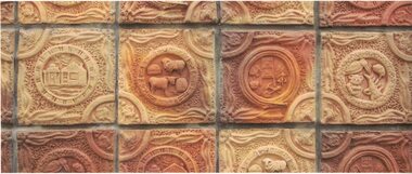
Photograph, Detail of Handmade Tiles on Public Toilet Block, Linton
The tiles were made by Linton Primary School pupils and members of the community as part of the Press Mould Tile Project 2001-2002. See Registration no. 2019-184 for more information.Colour photograph which shows handmade tiles used to clad the Linton public toilet block near the Shire offices in Sussex Street. The tiles depict stock animals, wildlife and historic themes, such as gold mining.public toilet building linton, hand made tiles, terracotta tiles, community art projects, press mould tile project 2001-2002 -
 Lakes Entrance Historical Society
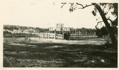
Photograph - Lakes Camping Park, Jemmeson Edie, 1928
This fully self contained camp park containing accommodation, general store, entertainment, Rotunda, petrol bowsers and community kitchen was the vision of Richard Bromby Whiter, who commenced the project in 1927. Water for gardening and sewerage supplied by an underground bore.Small format black and white photograph of the entrance to the planned Lakes Camping Park, fronting Roadknight Street. Shows sign at the rear of block on timber fence, other buildings in background. Lakes Entrance Victoriatourism, recreation, caravan parks -
 Bacchus Marsh & District Historical Society
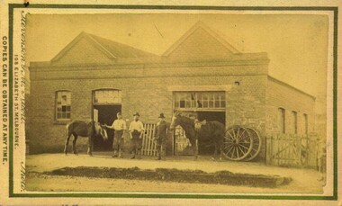
Photograph, Marshall's Blacksmith Shop 1883
This image is one of a series of photographs taken by Melbourne based photographers Stevenson and McNicoll who visited Bacchus Marsh and its nearby districts between September and November 1883. William Marshall opened his new premises in Main Street in June 1869. In the following November he opened a wheelwright shop adjacent to his smithy. Mr T. Carlton was the wheelwright. The Marshall Blacksmith building was located next to the ANA Hall in Main Street. It was demolished in 1910 to make way for a new building known as the Chambers Building. In the nineteenth and early twentieth centuries, the blacksmith played an essential role in the functioning of the whole community. Before the industrialisation of manufacturing, all metal objects, including farm implements, building requirements and domestic utensils were made by hand. As mechanisation of industry increased, the smith commonly performed the role of farrier in the times when horse power was pivotal to all aspects of society. Complementing this work, the forge was often allied with a wheelwright's shop. These premises also acted as a meeting place for the men of the town, where news was shared and friendships forged. Small sepia 'carte de viste' style unframed photograph on card with gold border framing photograph. Housed in the album, 'Photographs of Bacchus Marsh and District in 1883 by Stevenson and McNicoll'. William Marshall opened his new premises in June 1869, and in the following November opened a wheelwright shop adjacent to his smithy. Mr T. Carlton was the wheelwright. The photograph shows a brick building with two gables and two large doors, indicating that a second workshop has been added to the original building. Parts of a picket fence and two cartwheels lean against the wall. Three men stand at the front, two wearing the distinctive farrier’s apron slit between the knees. The third man is wearing more formal clothing. Two of the men hold the reins of two horses. A picket fence runs along the front of a spare block at the side of the building. The deep gutter is straddled by two crossing points. Printed On the front: Stevenson & McNicoll. Photo. 108 Elizabeth St. Melbourne. COPIES CAN BE OBTAINED AT ANY TIME. On the back: LIGHT & TRUTH inscribed on a banner surmounted by a representation of the rising sun. Copies of this Portrait can be had at any time by sending the Name and Post Office Money Order or Stamps for the amount of order to STEVENSON & McNICOLL LATE BENSON & STEVENSON, Photographers. 108 Elizabeth Street, MELBOURNE. blacksmiths, shops bacchus marsh vic., william marshall 1839-1914 -
 Wodonga & District Historical Society Inc
Photograph - Free Serbian Orthodox Church, Wodonga
When the Free Serbian Church was established in Wodonga it was the only one in a country centre and the third Serbian Church established in Australia. It had a congregation of approximately 40 members. The Church was originally the first Presbyterian Church in Wodonga. It is a rectangular brick building with a red Colourbond gable roof to the nave area and a domed roof to the rear of the nave. Many features of the architecture from the original building remain. However, changes were made during the refurbishment by the Free Serbian congregation. The original façade red brickwork was rendered and painted white and it was modified to include two round arched relief panels. The upper relief panel was divided into three blocks of colour - red, pale blue and grey, with a centrally located gold cross. The relief panel above the double timber front doors has a gold cross and Serbian iconography. A cross was located on the wall at the apex of the gable and a cross rising up from the gable. The original pointed gothic style windows were replaced with round arched windows. The window hardware now includes wrought iron decorative features. A domed roofed area was constructed to the rear of the nave. The perimeter fence and gates included decorative wrought iron elements. The gates are particularly decorative with floral emblems and Serbian and English text in wrought iron. These photographs are significant because they provide evidence of the changing nature of religious worship and groups in Wodonga.A collection of black and white and coloured photographic images depicting the Free Serbian Orthodox Church, Wodonga. The Church was originally the first Presbyterian Church in Wodonga. It was extensively modified in 1961-62.free serbian orthodox church, wodonga churches, presbyterian church, religion wodonga -
 Eltham District Historical Society Inc
Photograph - Digital Photograph, Alan King, Kangaroo Ground Presbyterian Church, 28 December 2007
Built in 1878, the orange polychromatic brick structure replaced a slab building which had been used since 1951. The building has changed little with its handsome bricks buttressed on both sides, a slate roof and a Celtic cross on top of the front gable. The carved wooden pulpit and 18 pews are original. The cathedral-style ceiling is fully lined with tongue-and-groove pine boards and the floor is also pine. The walls have arched oblong leadlight windows. In 1977 the congregaton decided not to join the Uniting Church, whcih amalgamated some Presbyterian churches with all the Methodist and Congregational churches in Australia. Together with the store and school, the church is one of Kangaroo Ground's three public buildings. Covered under Heritage Overlay, Nillumbik Planning Scheme. Published: Nillumbik Now and Then / Marguerite Marshall 2008; photographs Alan King with Marguerite Marshall.; p91 The small Presbyterian church in Main Road, Kangaroo Ground, has been a spiritual centre for more than a century. Built in 1878, the orange polychromatic brick structure replaced a rude slab building, which had been used as both a church and school since 1851. Earliest settlers, who were Scottish farmers, had worshipped together since 1841 in a barn owned by farmer James Donaldson and led by a layman called Smith.1 However, from 1843, the Reverend Peter Gunn conducted church services. Prominent early church members include the Donaldson, Bell and Cameron families. In 1851, Samuel Furphy (father of author Joseph) built their first church building, a 30 feet x 18 feet (9m x 5.5m) slab structure on half an acre (0.2ha) donated by Mr Donaldson. Conditions could be very uncomfortable in extreme weather.The green slabs of timber and sapling logs, covered partly with mud, had centimetre-wide cracks, allowing rain and wind through, when not blocked out by folds of paper.2 However this did not deter the first couple marrying there in 1857: John Wilson of Nillumbik and Christina Macpherson of Christmas Hills. The Reverend Peter Gunn seldom visited so it was usually left to Andrew Ross, the settlement’s first teacher and founder of the newspaper The Evelyn Observer, to lead the divine services instead.3 In 1877 the settlers raised £355/19/- and hired architect, Charles Maplestone and builder, Mr Self, to construct today’s church building. Each family rented a pew or pews for ten shillings a half-year; they also paid quarterly subscriptions for the minister’s stipend.4 It was not until 1886 that the church celebrated its first wedding, that of John Bell (junior) from Violet Bank and Elizabeth Charlton of Cunis Nillen. The Sunday School’s first recorded meeting was also held that year. In 1892 a weatherboard vestry was built, and the following year John Bell donated a church bell, which the fire brigade used as a warning for several years. Conditions have varied greatly during the century. In 1893 the Reverend Darroch had to travel more than 2000 miles (3220km) to attend to his scattered parishioners. Then in the Depression, the minister Mr Brown, subsisted only on lodgings with no stipend. The Sunday School ceased for many years because of the small population, but reopened in 1949. The building has changed little with its handmade bricks buttressed on both long sides, a slate roof and a Celtic cross on top of the front gable. The carved wooden pulpit and 18 pews are original and in fine condition. The cathedral-style ceiling is fully lined with tongue-and-groove pine boards and the floor is also of pine. The walls have arched oblong leadlight windows. One window has stained glass commemorating Mrs Jessie Agnes Cameron and her ancestors – the pioneering Bell family. It depicts The Sower because the family comprised farmers who came to a strange land to sow the seeds of their faith as much as their crops. Thistles signify their Scottish ancestry and the pigeons are a symbol of Pigeon Bank, the Kangaroo Ground farming property where Jessie Cameron was born.5 Other historical ties are seen on two marble memorial tablets and carved wooden chairs dedicated to former members. The Church still has the original Bible with gold edged paper, presented by the women of the congregation in 1871, although it is no longer used. In 1977 the Presbyterian congregation decided not to join the Uniting Church, which amalgamated some Presbyterian churches with all the Methodist and Congregational churches in Australia. Together with the store and school, the church is one of Kangaroo Ground’s three public buildings.This collection of almost 130 photos about places and people within the Shire of Nillumbik, an urban and rural municipality in Melbourne's north, contributes to an understanding of the history of the Shire. Published in 2008 immediately prior to the Black Saturday bushfires of February 7, 2009, it documents sites that were impacted, and in some cases destroyed by the fires. It includes photographs taken especially for the publication, creating a unique time capsule representing the Shire in the early 21st century. It remains the most recent comprehenesive publication devoted to the Shire's history connecting local residents to the past. nillumbik now and then (marshall-king) collection, kangaroo ground presbyterian church -
 Eltham District Historical Society Inc
Photograph - Digital Photograph, Marguerite Marshall, Jelbart home, 93 Arthur Street, Eltham, 11 November 2006
Situated at the top of the hill in Arthur Street, the former Jelbart residence and barn were part of a major change that transformed Eltham's character in the late 1960s. Built from the mid 1940s through mid 1950s when Eltham was a rural community, the Jelbrat residence and barn are all that remain of a family property of some 250 acres (100 ha). With growing population pressures, in the late 1960s, owners Ron and Yvonne Jelbart decided to subdivide their property creating the Woodridge Estate in the early 1970s, a major factor towards the transformation of Eltham to the suburb it is today. The Jelbarts had moved to Eltham in the early 1940s when they purchased a poultry farm in New Street, now Lavendar Park Road. (The local Black Friday bushire of January 13, 1939 had started at C.A. (Clarrie) Hurst’s Eltham Poultry Farm and Hatchery in New Street.) Jelbart was primarily a businessman importing office machinery but desired farm beef and dairy cattle so the couple purchased the virgin bushland at what was then at the end of a dirt road, Arthur Street. With post war shortages of most building materials, they followed the example of the Eltham Artists' Colony (later called Montsalvat) and built thier home from mud-bricks and recyclked materials. The barn was first to be completed in 1945 which they made their home whilst building the main residence. It took eight years to complete the two buildings. Both the main residence and the barn are now separate homes, and along with the remaining property being sub-divided further in 1998 are now part of the Kinloch Gardens Estate at 93 Arthur Street. Covered under Heritage Overlay, Nillumbik Planning Scheme. Published: Nillumbik Now and Then / Marguerite Marshall 2008; photographs Alan King with Marguerite Marshall.; p139 Standing on a hilltop at Arthur Street, Eltham, the Jelbart residence and former barn were part of a major change that transformed Eltham’s character in the late 1960s. Built from the late 1940s to the mid 1950s when Eltham was a rural community, they are all that remain of what was once a family property of around 250 acres (100 ha). As population pressure increased in the late 1960s, owners Ron and Yvonne Jelbart, decided to subdivide their property. The break-up of this property into the Woodridge Estate in the early 1970s, was a major factor towards transforming Eltham into the suburb it is today.1 Although standing only a few minutes from Eltham’s busy hub and hundreds of houses in Woodridge, scarcely any urban sound disturbs the peace. Views from the two buildings are almost exclusively of trees and extend to Mt. Dandenong to the south-east, the Great Divide to the north, and Melbourne city to the south-west. The Jelbarts had lived in Eltham since the early 1940s when they bought a poultry farm in New Street, now Lavender Park Road. Although Jelbart was primarily a businessman importing office machinery, he was keen to farm dairy and beef cattle, so the couple bought rough bushland at what was then the end of Arthur Street. But a shortage of building materials following World War Two hampered their plans to build their new home, so they followed the example of the Eltham Artists’ Colony (later called Montsalvat) and used mud-bricks and recycled materials.2 With great determination the family and friends constructed their house. Massive timber frames and huge quantities of mud-bricks were made on site. The barn was built first in 1945, and two years later, while camping inside, the Jelbarts started building their house. It took eight years to construct the two buildings, even with the help of professional tradesmen. The buildings, with timber frames infilled with mud-brick and plastered, are reminiscent of the English Tudor style. The Jelbarts are of Cornish stock. Much of the timber framework came from demolished bridges or warehouses, and recycled slate was used for roofs and floors. Quality second-hand materials were readily available in the late 1940s and 1950s when there was much demolition in Melbourne and little respect for heritage. A former 19th century Toorak mansion Woorigoleen provided the magnificent stone fireplace, the timber panelling and the parquetry floor in the living room. The large stone gateposts at the entry of the property came from Melbourne University. Almost no mechanical equipment was used to build the 55 square house and the 25 square barn. Massive timber frames were erected using block and tackle pulleys and timbers were shaped, sawn and drilled by hand. Son and architect Ian, with his family, have lived in and extensively renovated both buildings since the early 1970s. Ian transformed the steep ridge of the property into a plateau, where the main house Kinloch stands, surrounded by terraces and lawns. The grounds retain many native plants, including massive yellow boxes – some nudging 80 years. Ian attached 70 metres of pergolas draped with wisteria, roses and grape vines, to three sides of the house. The beautiful garden is featured in the book Through the Rose Arbour by Rosemary Houseman. The two-storey barn – now a house – retains traces of its original use. The cow-shed with milking and feed-rooms, and the machinery-shed remain. The house, separated on the ground floor by a breeze-way, soars two storeys and includes a mezzanine. These are connected by spiral staircases, to timber-beamed and plaster-lined high-pitched ceilings. The house also descends to a wine cellar. Curiously the roof is of corrugated iron on the south and slate on the north, to save costs. Small-paned windows and three French doors open onto the front lawn, which extends to Jelbart Court.This collection of almost 130 photos about places and people within the Shire of Nillumbik, an urban and rural municipality in Melbourne's north, contributes to an understanding of the history of the Shire. Published in 2008 immediately prior to the Black Saturday bushfires of February 7, 2009, it documents sites that were impacted, and in some cases destroyed by the fires. It includes photographs taken especially for the publication, creating a unique time capsule representing the Shire in the early 21st century. It remains the most recent comprehenesive publication devoted to the Shire's history connecting local residents to the past. nillumbik now and then (marshall-king) collection, eltham, arthur street, jelbart barn, jelbart home, kinloch gardens -
 Surrey Hills Historical Society Collection
Photograph, Timothy Leigh's Estate Agency, c 1900, c 1900
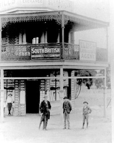
Donor information is that the man is Timothy Leigh and the boys are his sons. The building was on the corner of Union Road and Sunbury Crescent. This site was later occupied by New Litho P/L (printers).B&W photo of a 2 storey Victorian building with ornate lacework trim and veranda panels to the upper storey. Signage on the veranda includes "South British Insurance Fire Company" and "T Leigh Land & Estate Agency". The block next door is vacant with some coverage with small trees. A man and 3 boys are standing in front of the building on the roadside.Diagonally across the top LH corner in black ink: "JB & H Leigh" Top centre: "C/O Sunbury Cres and / Union Rd / c1893 / Timothy LEIGH and sons" in blue biro in Alan holt's handwriting, the in the same handwriting on a rectangular white sticker: "SURREY HILLS PROPERTY EXCHANGE BUILDINGS / (N.W. corner of Sunbury Cres and Union Rd SH) / c1893 / Timothy Leight - Estate Agent / with sons Henry and Herbert / (From Mrs Esler HENSHAW of C'bury - Granddaughter / of Timothy and daughter of Henry LEIGH)" Then centre in the same handwriting "3129" Then on a white sticky label in Jocelyn Hall's handwriting: "Given by Mrs Henshaw / to Alan Holt / who gave them to / N. C. Collection" leigh, timothy, real estate agents, insurance agents, t leigh life & estate agency -
 Melbourne Tram Museum
Postcard - Collins St at Elizabeth St - John Hinde Studios - W2 class trams, John Hinde Studios, early 1970's
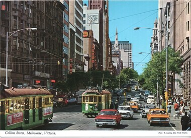
Postcard looking east along tree lined Collins St from Elizabeth Street with many now demolished buildings in the view. Buildings at the time include Block Court, Victour, Kodak, Souther Cross, Howey Court. Trams in the view are W2 224, W2 253 (Spencer Street Route 11) and three other W2 class trams. Appears to be an Inspector standing at the west end of the Safety Zone.Yields information about Collins Street early 1970s and the motor car traffic.Postcard - Collins St at Elizabeth St - John Hinde Studios 2 AUS 34trams, tramways, safety zones, traffic, w2 class trams, tram 224, tram 253, victour, kodak, block court, collins st -
 Melbourne Tram Museum
Postcard - Bourke St with PCC 1041, Carinya Postcards, mid 1970s
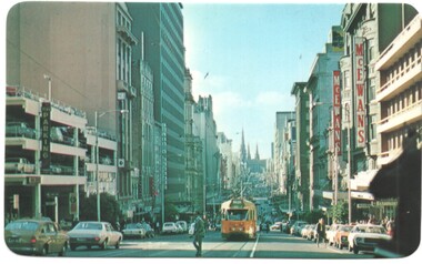
Carinya postcard looking east from Queen St with PCC class tram 1041 westbound to Spencer St. Has the McEwans building in the view along with a multistory car park.Yields information Bourke St and the use of PCC class tram 1041, the forerunner of the Z class tram.Postcard - by Carinya Postcards with rounded corners, address block, Number LV028trams, tramways, bourke street, pcc class, tram 1041, mcewans -
 Vision Australia
Photograph - Image, St Kilda Road building in 2010, 6/1/2010
In 2007, Vision Australia sold it's iconic 557-563 St Kilda Road site. The historic bluestone building was in need of renovation and repair, had limited space for staff and clients and with more demand for services in suburban and regional areas, did not meet the needs of the national organisation. The purchaser was mainly interested in the Ormond Hall section, which they sub-divided off and sold to the tenant of the Belgian Beer Cafe. The remainder of the site was then sold on to another developer. Unable to quickly proceed with their plans on developing the site for residential buildings, the site fell into some disrepair in the interim which was when these images were taken. Later the site was sold again and residential buildings now occupy part of the block. 20 images taken of and from St Kilda Road buildingroyal victorian institute for the blind, buildings, myer house, ferguson and urie -
 Clunes Museum
Plant specimen - WOODEN BLOCK
... Clunes Sawmills Used for building finishes Block of wood (hemlock ...Block of wood (hemlock), the top half is "dressed" to show how timber is prepared. Typically, the flitch beam is made up of a vertical steel plate sandwiched between two wood beams, the three layers being held together with bolts. Typed onto cardboard pinned onto wooden block; Hemlock Bought in flitches Milled Clunes Sawmills Used for building finisheshemlock, clunes sawmills, flitch, sample -
Merbein District Historical Society
Drawing, Folio, Engineering Drawings, 1944-1949
agricultural equipment, industrial equipment, building industry, tractors, merbein co-op, implements, block equipment, williams & lawler, les stack, williams maurie -
 Linton and District Historical Society Inc
Photograph, Unidentified Event
Photograph of unidentified event, late 19th/early 20th century, possibly a gathering of the Linton Caledonian Society. Photograph shows group of people gathered on a grassy area/open space in front of a wooden building, trees in background. Some of the group are wearing uniforms and appear to be members of a brass and/or highland band. To the left is a wagon/cart with baggage and chairs(?) loaded on it. To the right is a horse-drawn cart with people seated on it, other people standing just behind it. About ten small children are in a row at the front of the group. A sign just behind them reads "A Chip Off the Old Block". Two flags are flying, one an Australian flag, the other a Union Jack. -
 Southern Sherbrooke Historical Society Inc.
Photograph - Bert and Minnie Sutton c.mid 1940s
B&W photo of Bert (Gilbert William) and Minnie (Williamina Wilson) Sutton (daughter of Charles Macauley and Minnie Gray) standing outside their original home in Belgrave Heights. The photo shows the couple standing at their post-and-wire front fence at their property in Lockwood Road. The house was next door to Edward's store. Bert is in shirtsleeves and Minnie is wearing a cardigan over a dress. Their house is a single gabled house of weatherboard and fibro sheeting with an L-shaped open verandah. After purchasing the house Bert altered it, eventually enclosing the verandah and turning it into a sleepout. The house has been extensively altered since but is still standing in Lockwood Rd. The block is treed and the garden appears to be rather wild. A tiled roofed building is behind the house and to the left, possibly a garage. On the nature strip in front of the Suttons' house is a wooden bench, and attached to a tree are the signs, "Lockwood House" (with a hand pointing right), "To golf links" (with an arrow pointing right) and "Central Park Tennis Courts" (with an arrow pointing left). The sun is shining. Bert, who was a carpenter, died in 1969 and Minnie died in 1977. Copy of original photo donated to our society by Kath Oram, a founding member. -
 University of Melbourne, Burnley Campus Archives
Album - Colour 35mm slides, James (Jim) Pleasance, Miscellaneous Burnley Views, 1975-1988
Box of coloured slides, all from different collections. (1) "Students Margaret Oliver," on reverse,"Equipment 2190 Cultivator" (2) "Green manure crops. Field peas lupins." 1975 (3) "B.H.C." on reverse, "Seed beds." (4) "29/4/64 Crops Section." (5) "Seed Testing Lab (1966)." (6) "Julie Provan Peach stock Block." Sep (7) View of back of lawn." Aug 1980 (8) View of Ponds." ((0 Constructing Native Garden. (10) Crack Willow in winter. Jul 1978 (11) Crack Willow in summer. Jul 1988 (12) Administration Building. 1985 (13) Blossom. (14) Blossom on fruit trees. Sep (15) Children Planting. Aug 1985. Also others.students, margaret oliver, cultivator, lupins, crops section, seed testing lab, julie provan, lawn, ponds, native garden, blossom, fruit trees, children, planting, green manure, garden views, administration building, crack willow, peach blossom, orchard, sunken garden, rose garden, flowers, acacia maidenii, vegetables -
 Melbourne Tram Museum
Photograph - Block Mounted Photograph, Ron Scholten, c1970
Chipboard base for a block mounted black and white photograph of Elizabeth St Melbourne at Franklin St. Has a stapled nylon cord on rear to provide a hanging method. Has tram W5 728 north bound to Brunswick on a route 18. In the background is the Argus building, printers of The Argus and The Australasian. Note the safety zone. Photo and story along with a photograph by Warren Doubleday of the same location September 2014 used in the October 2014 issue of Bellcord - see image i3. First two pages extracted only.On rear in ink at the top - "Donated to Hawthorn Tram Museum Feb. 19th 2012 Ron Scholten"trams, tramways, elizabeth st, brunswick, route 18, the argus, franklin st, tram 728 -
 Bendigo Historical Society Inc.
Photograph - T C WATTS & SON, 1927
BHS CollectionBlack and white photograph mounted on rectangular grey board. House, hipped CGI roof, two chimneys, brick whitebands and decorative tops, hipped C.G.I. verandah w/fluted wooden posts w/capitals and cast iron lace above. Wooden verandah floor. 4 lines of ''block patterned'' w/boards [these boards are white].place, building, residential, stamped on back ''t.c. watts and son'' stamped on back in circle ''royal historical society of victoria, bendigo branch'' -
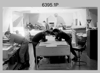 Bendigo Military Museum
Photograph - Army Survey Regiment – Map Production, Fortuna, Bendigo, 1986
These 17 photographs of the Army Survey Regiment’s map production and facilities were taken at Fortuna Villa, Bendigo, April 1986. Photos .1P to .3P were taken in Cartographic Squadron’s Correcting Section in the Attic. located on the top floor of Fortuna Photos .4P to .5P were taken in Cartographic Squadron’s Proving Section, located in the Ballroom also on the top floor facing the lake. The technicians were probably involved in a rapid response map production, as they all were wearing field uniforms. As ‘Regiment Overcrowding’ is annotated on the plastic sleeve holding the negatives, it seems the photos were taken when the unit was at its capacity to demonstrate the lack of suitable work areas. The Army Survey Regiment’s Duty Room, RAP and Carpark appearing in Photo .10P was probably taken from the top steps near the SGT’s accommodation block. Two of the photos in this set are also published in item 6096.5P.This is a set of 17 photograph of Map Production and car park was taken at the Army Survey Regiment, Fortuna, Bendigo, in April 1986. The black & white photographs are on 35mm negative film and are part of the Army Survey Regiment’s Collection. The photographs were scanned at 96 dpi. .1) - Photo, black & white, 1986. Correcting Section, Attic: L to R: CPL Andy Lucas, SPR Chris Gordon, unidentified, SPR Jan (Crighton) Minchin, CPL Robin Marshall, CPL Frank Downie, SPR Gayle Humphrey, unidentified (x2), Jason Wells at rear. .2) - Photo, black & white, 1986. Correcting Section, Attic: L to R: CPL Andy Lucas, SPR Chris Gordon, unidentified, SPR Jan (Crighton) Minchin, CPL Robin Marshall, CPL Frank Downie, SPR Gayle Humphrey, unidentified, Jason Wells, unidentified. .3) - Photo, black & white, 1986. Correcting Section, Attic: L to R: CPL Andy Lucas, CPL Robin Marshall, SPR Chris Gordon, unidentified, CPL Frank Downie, SPR Gayle Humphrey, unidentified, SPR Jan (Crighton) Minchin at rear., Jason Wells on phone. .4) & .5) - Photo, black & white, 1986. Proving Section, Ballroom: On left front to back: SGT Alan Staley, SGT Roger Rees, SGT Greg Anderson. On right front to back: SGT Denis McCarthy, SGT Tim Allanson, SSGT Adrian ‘Charlie’ Creedy. .6) - Photo, black & white, 1986. Records & Proofing buildings. .7) - Photo, black & white, 1986. Technical Services temporary buildings. .8) - Photo, black & white, 1986. Q-store and transport buildings. .9) - Photo, black & white, 1986. Technical Services temporary buildings in front of transport compound. .10) - Photo, black & white, 1986. Army Survey Regiment Duty Room, RAP and Carpark at Fortuna. .11) - Photo, black & white, 1986. Records & Proofing buildings. .12) - Photo, black & white, 1986. Other Ranks (OR’s) car park and barracks with kitchen in background. .13) - Photo, black & white, 1986. Other Ranks kitchen, parade ground and SGT’s/Officers barracks in background. .14) - Photo, black & white, 1986. Fortuna Villa taken from the steps near the SGT’s accommodation block. .15) - Photo, black & white, 1986. Fortuna Villa taken from the steps near the OR’s s accommodation block. .16) - Photo, black & white, 1986. Fortuna Villa taken from the roadway near the OR’s accommodation block. .17) - Photo, black & white, 1986. 20’ x 30’ Army tents set up on the basketball court..1P to .17P – ‘Regiment Overcrowding’ and the date are annotated on the plastic sleeve.royal australian survey corps, rasvy, army survey regiment, army svy regt, fortuna, asr -
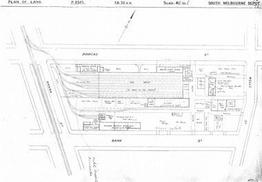 Melbourne Tram Museum
Drawing, Melbourne & Metropolitan Tramways Board (MMTB), "South Melbourne Depot", c1937
Set of five photocopied plans or drawings on A3 sheet of "South Melbourne Depot" - c 1937 .1 - P8345 - Plan of land showing MMTB land and surrounding properties. .2 - P8346 - Plan of land showing detail of offices .3 - P8347 - Plan showing detail of tram shed and adjacent buildings .4 - P8348 - Plan showing detail of buildings along the side of the block. .5 - P8349 - Plan showing details of the per way yard and associated facilities.trams, tramways, drawings, depots, property, south melbourne depot -
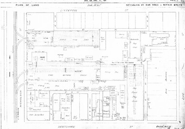 Melbourne Tram Museum
Drawing, Melbourne & Metropolitan Tramways Board (MMTB), "Central Bus Garage", "Nicholson St car shed and repair shops", c1938
Set of four photocopied plans or drawings on A3 sheets of the "Central Bus Garage" and the "Nicholson St car shed and repair shops" .1 - Plan showing block and details of the cable car facilities, repair shops and car paint shop - drawing dated 28-7-1933. .2 - Plan of the block showing the various properties and buildings - shows bus garage location. .3 - South part of drawing No. 1019 - showing the various properties, title details, purchased costs and dates - includes the hospital at Rae St - see Reg Item 1738.2 for details. Dated 8/1940. .4 - North part of the above drawing.trams, tramways, drawings, depots, property, cable trams, nicholson st, central bus garage, buses -
 Melbourne Tram Museum
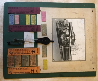
Ephemera - Ticket/s, Melbourne & Metropolitan Tramways Board (MMTB), "Cable Tram Conductor's Ticket Pins", c1930
Poster - featuring a photo of a cable tram in Elizabeth St at Pelham St, 12 small cable tram tickets and four bell punch tickets, along with a leather button ticket pin holder and four safety pins. Items placed on a large sheet of cardboard with a green overlay. The photo, pin holder and four small tickets and the bell punch strip tickets glued onto a off white sheet with brass folded pins securing the items to the green card. The rest of the tickets glued to the green card. Underneath is a small sign with the words in blue and red colours "Cable Tram Conductor's Ticket Pins". Photo - grip car - well loaded showing destination of Brunswick and a sign on the side "Direct to Football". Behind the Gripman is a conductor. Bogie cable trailer 480. In the background is the building on the corner of Elizabeth St and Pelham St (still there in 2018) and in the background is Evan Evans the flag makers building. 192H x 248W - has silver fish damage along top edge, lifting in the top left hand corner from the backing sheet and minor edge damage. Dirt marks Small Tickets from Top left hand to Bottom right hand. Tickets 1, 4 to 8 - torn from a strip - pre-purchased? Tickets 9 to 12, torn from a block. Each Ticket has been separately imaged. T1 - 1 1/2d City Tram ticket - Trip Slip -MTO-Co - pink card with purple ink - faded, punched - 27H x 59W T2 - Transfer, MMTB, from Carlton and Prahran lines to other lines as indicated by punch marks with times by the quarter hour - green print on off white card - 31H x 71W - faded. T3 - as above - but not so faded, part town in bottom left hand corner. T4 - 1 1/2d - cable tram section ticket - MMTB - brown print on yellow card - not punched - 24H x 58W T5 - as for 1 - but MMTB - green print on yellow card - heavily creased - 26H x 57W T6 - similar to 5, smaller dimensions and not heavily creased. T7 - 1 1/2d general ticket - detailing lines or section - red ink on pink card - 26H x 56W T8 - 2d - MTCo - Adult or two children under 12, single, black ink on blue card - 24H x 58W T9 - Prahran and Toorak cable tramways check ticket - transfer - conditions on ticket - has 114 in top right hand corner, orange paper, black ink, MMTB - 36H x 67W. T10 - Carlton and Prahran - as for 9, with 17 in top right hand corner, grey paper with black printing - 38H x 65W. T11 - Carlton, N. Carlton, Prahran, St Kilda - as above - 105, brown paper, black ink - 38H x 65W T12 - as for 9, but with 74 in top right hand corner - 35H x 71W Strip tickets - left to right S1 - 1 1/2D, bell punch type - 15 fares - purple card black printing - Up ticket - 182H x 39W S2 - ditto - down direction, no conductor details - 182H x 37W S3 - ditto - 3d, Up direction, orange card, black print - 182H x 39W - has some dirt marks S4 - ditto - 3d down direction - 138H x 38W - has some dirt marks. Leather buckle - cut leather with a strip to secure the pins - button hole on the base with four safety pins placed into it. Pins have rust marks and general deterioration. Leather - 90H x 45W, pins - 3 about 90H x 25W and one 55H x 16W. See Reg Item 1923 for the use of the pins and leather buckle.trams, tramways, cable trams, brunswick, elizabeth st, football, tickets, conductors, mmtb, mto co, transfer tickets, tram 480, trip slips -
 Melbourne Tram Museum
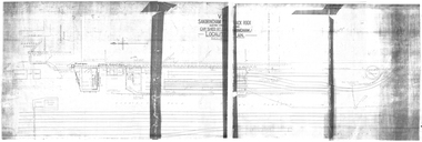
Drawing, VR Sandringham Tram Depot, 1921
Set of 8 drawings, prints from original VR drawings of the Victorian Railways Sandringham Railway station, tram depot, bus depot and alterations between 1921 and 1958.\ .1 - VR Sandringham to Black Rock, Electric Street Railway – Car shed at Sandringham – Locality Plan – shows car depot layout, substation, track location for both the railway and tramway, including the platform, goods shed and coal stage. Not dated. Consists of two sheets of paper joined in the middle – 420H x 1210W. Minor creases at end of rolled sheet. .2 - Drawing 1907.21 - Sandringham car shed proposed extension – with note “Not carried out” – dated 2-8-21 Second copy has stamp – Drawer 2, Folio 1, plan 2 in bottom left hand corner. 480H x 630W .3 - Sandringham Station – station layout showing proposed extension to passenger platforms for both 7 and 10 car trains, buildings shops as the southern end of the yard, rail and tramway tracks, streets, dated 12.2.1923. Drawing 582.22. 420H x 590W. .4 - Locker Room for Bus Drivers – plan 264-46, dated 2-5-1946, 295H x 420W. .5 - Shower for Bus Drivers, Plan No. 815-50, dated 15/12/1950, 295H x 420W. Has a note on the drawing – “not carried out”. .6 - Tramcar shed – Site Plan – Entrance Gates – shows conversion arrangements of the depot from trams to buses, including entrance way gates. Plan 456-56. 295H x 420W. .7 - Conversion of sub-station into New Amenities Block - plan number 51-57, dated 22.2.1957 - Detail architectural drawings for the above work. 295H x 420W .8 - Conversion of sub-station into New Amenities Block - plan number 51-57, dated 22.2.1957 - Detail architectural drawings for the above work. 295H x 420W. .9 - Proposed Improvements to Bus Depot - Plan No. 455-52 - not dated. 420H x 595Wtrams, tramways, vr, sandringham, tramways, buses, railways, black rock -
 Melbourne Tram Museum
Photograph - Set of 10 Colour Print/s, Steven Altham, 2001
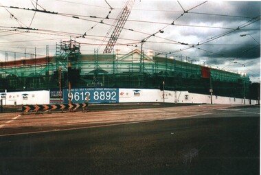
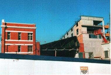
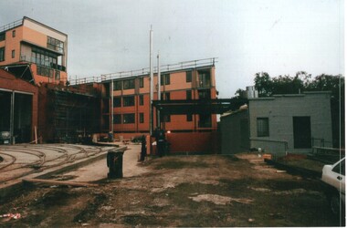
Set of 10 colour prints of the re construction of the Hawthorn Tram Depot to the Watermark Apartments. .1 - Depot fan Trackwork - 6-2-2001 .2 - ditto looking towards tram depot .3 - view towards the building with the second depot demolished, and forecourt excavations underway - 11-3-2001 .4 - Sign on the building advertising apartments .5 - view from street looking at the old depot wall with drilling rigs. .6 - ditto, looking at the worksite for the new block of apartments and part of the original buildings remaining. .7 - Car park slabs being formed. 11-6-2001 .8 - looking at the south wall of the first depot showing the scale of excavation and underpinning. .9 - looking south west/ .10 - Looking from the street at the car park slab in front of the depot. Colliers Jardine and Bovis Lend Lease signs in the photos.All have details of photograph on rear and photographers name.trams, tramways, watermark apartments, hawthorn depot, construction, tram depot -
 Melbourne Tram Museum
Photograph - Set of 7 Colour Print/s, Steven Altham, 27/12/2001 12:00:00 AM
Set of 7 colour prints of the re construction of the Hawthorn Tram Depot to the Watermark Apartments. All taken on 27-12-2001. .1 - view from the intersection of Power and Wallen Road, looking to the original building with scaffolding. .2 - View from Power St extension looking west. .3 -View from Wallen Road showing new block and tram track into the depot. .4 - View of the original building from Wallen Road. .5 - View from the gardens looking north showing the new block. .6 - ditto .7 - ditto Colliers Jardine and Bovis Lend Lease signs in the photos.All have details of photograph on rear and photographers name.trams, tramways, watermark apartments, hawthorn depot, construction, tram depot -
 Melbourne Tram Museum
Photograph - Set of 3 Colour Print/s, Postcard, Steven Altham, 29/04/2002 12:00:00 AM
Set of 3 colour prints of the re construction of the Hawthorn Tram Depot to the Watermark Apartments. All taken on 29-4-2002 .1 - view from the west side looking at the original buildings, no front wall to the depot part and the new apartment block. .2 - ditto .3 - Looking at the west end of the new block and car park entrance, no tracks laid.All have details of photograph on rear and photographers name.trams, tramways, watermark apartments, hawthorn depot, construction, tram depot -
 Melbourne Tram Museum
Photograph - Set of 9 Colour Print/s, Steven Altham, 27/02/2002 12:00:00 AM
Set of 9 colour prints of the re construction of the Hawthorn Tram Depot to the Watermark Apartments. All taken on 27-2-2002 .1 - View from Wallen Road with the track work relaid, new end wall on the original building and the facade for the 2nd depot being constructed. .2 - new facade to the original section of the depot with tracks. .3 - part of the new apartments .4 - From Power St looking between the original and new buildings. .5 - ditto .6 - ditto .7 - looking from Power St at the south end of the new block. .8 - view of trackwork and fan concreted in. .9 - ditto Colliers Jardine and Bovis Lend Lease signs in the photos.All have details of photograph on rear and photographers name.trams, tramways, watermark apartments, hawthorn depot, construction, tram depot -
 Melbourne Tram Museum
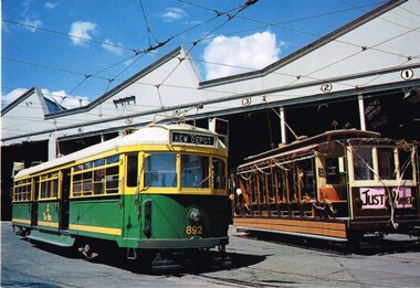
Postcard, Kew Depot Committee - AETA, "Kew Depot - 75 years of Service", 1991
Postcard photo of W 892 and V 214 with wedding decorations at Kew Depot, 1991, with the depot building in the background. On the rear has a photo of a destination blind - showing Kew Depot with the words "75 years of Service" underneath, address and stamp blocks, PMTT logo with an A class tram in the centre. In the bottom left hand corner are the details of the photo and photographer - Ray Marsh and the number T101. 2nd copy added 15/9/2020.trams, tramways, postcards, kew depot, victoria parade, celebrations, pmtt, weddings, tram 214, tram 892 -
 Melbourne Tram Museum
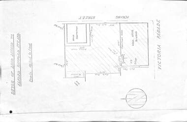
Drawing, Melbourne & Metropolitan Tramways Board (MMTB), "Detail of land leased to Alfred Kefford Pty Ltd", undated
Photocopy of a drawing or plan on an A4 sheet, titled "Detail of land leased to Alfred Kefford Pty Ltd" and the back of the former MMTB Office building in Victoria Parade Fitzroy. Gives the block dimension, streets, a location of a workshop and the brick office building. The Young St sub-station was excluded. Gives details of the fences. Plan undated. Rod Atkins advised 29/7/19 that Alfred Kefford nee Pty Ltd. resided at no 17 Young Street on corner of Duke Street just several doors further up Young Street on the same side. All I know so far is they were into some form of delivery type transport - i.e.. carrier.trams, tramways, mmtb, buses, lease agreement, victoria parade, young st, substation -
 Melbourne Tram Museum
Slide, Keith Caldwell, 12/03/1960 12:00:00 AM
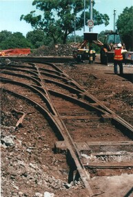
Agfa Colour slide, cardboard mount, by Keith Caldwell dated 12 March 1960, of W5 809 turning from Market St into Flinders Lane. Tram has two sets of monograms and numbers on the sides, is fitted with trolley wheels and showing route 55. Has an advertisement for British Bedford's vehicles on the front. The strip for the advert racks on the sides of the trams has been installed. In front of the tram is a remnant of cable tram track in wood blocks. In the background is the Flinders St Viaduct and the Port of Melbourne Authority Building.in ink on top of the slide "W5 (Cable tracks), Market" and hand stamped "12 Mar '60"trams, tramways, market st, flinders lane, w5 class, cable trams, tram 809