Showing 33219 items matching "buildings/streetscapes"
-
 Hume City Civic Collection
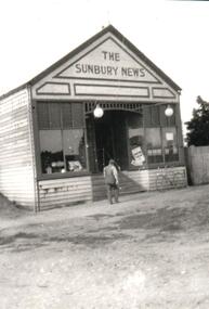
Photograph, Early 1900s
The Sunbury Newsagency and Sunbury News building was originally sited in Brook Street on the site of the present newsagency from 1900 to 1910. It was then moved over to Evans Street, next to the Post Office.A black and white photograph of the weatherboard Sunbury News building. A man with his back to the camera is outside the building and a bicycle is against the front of the building.sunbury news, boardman, eric, arthur, george evans collection -
 Rutherglen Historical Society
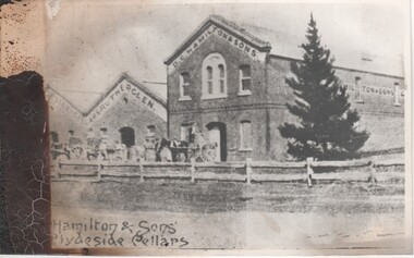
Image, c1890
One of a group of photographs salvaged from a fire, which took place in late 2007 or early 2008, at the cellars building that is now the home of the Rutherglen Estate tasting rooms and the Tuileries restaurant and accommodation. The building started as the cellars of D.G. Hamilton, and passed through the hands of Seppelts, before coming under its present ownership.Fire damaged black and white photograph of the front of a wine cellar.On front of building: "D. G. Hamiltons" At bottom of photo: "Hamilton & Sons, Clydeside Cellars"d g hamilton, rutherglen estates, tuileries, wine cellars, fires, clydeside cellars -
 Mission to Seafarers Victoria
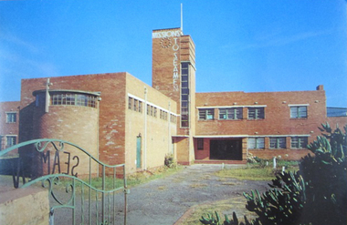
Postcard - Postcard, Colour, Alison Kelly, c. 1990
Also known as the King George V memorial building this branch of the Mission to Seamen opened in 1937 as a replacement for the old Mission in Port Melbourne. The Foundation stone was laid by the Victorian State Governor and a photograph of the event is also held in the MTSV collection. The Art Deco style building was commissioned by merchant and philanthropist, Alfred Michael Nicholas (1881-1937) and designed by prolific Melbourne-based architect Harry A. Norris (1888-1966) in 1937 best known for his commercial work in Melbourne city centre. NB PMHPS Kindly allowed MTSV heritage to take scans of the Kelly series notes in their collection for reference in 2019.One of the few full colour images of this building originally classified by the National Trust and now demolished. An example of architect Harry Norris' work 1937. All that remains are a ceramic plaque, a brick and several items of chapel artefacts. Alison Kelly, a photographer, was part of the group supporting the Port Melbourne Seamen's Mission in the 1980s and 1990s. She took a series of photographs of the building now held by the Port Melbourne Historical and Preservation Society.Full colour Postcard featuring colour image of a large red brick building in a 1930s era Architecture. There is a green wrought iron gate ajar in the foreground with the word SEAMAN spelled out. MISSIONS TO SEAMEN can also be seen spelled ut in white across and down the central clock tower of the building and this is surmounted with a white flagpole.On verso: Printed: "Heritage Series / POST CARD " at right angles in small print from lwr edge to upper: "PHOTOGRAPHY BY ALISON KELLY PORT HERITAGE SERIES NO 6". At Lwr left crnr printed:" Missions to Seamen Building, Port Melbourne/ Designed in the Modern style by architect Harry Norris,/ this 1937 National Trust classified structure was until 1972 / an entertainment and spiritual centre for seamen, with / important roles during the war [WW2] and immigration periods"king george v, memorial chapel, harry a. norris, brick, art deco, alfred m. nicholas, beach street, mission to seamen, alison kelly, 1937, arts centre, seamen mission, mission to seafarers, port melbourne -
 Glenelg Shire Council Cultural Collection
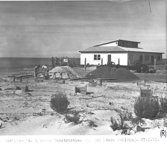
Photograph - Photograph - Portland Harbour Trust - Workshop no. 1, under construction and view of new store building, 27.3.53, 1953
Port of Portland Authority archivesFront: Workshop No. 1 under construction and New Store Building. 27.3.53. (lower centre) Back: P.H.T./ Print No. 3/16 Neg. No 149/ Date taken 27.3.53./ SUBJECT./ % (Ink stamp with blue pen and pencil additions, centre) Partial fingerprint in purple ink, lower centre.port of portland archives -
 Ringwood and District Historical Society
Photograph, Maroondah Highway West, Ringwood- c1920. Original Ringwood Market, Cnr. Maroondah Highway and Ringwood Street
Black and white photograph of wooden building. (2 copies)Typed under one copy: "Original Ringwood market and saleyards at corner of Maroondah Hwy and Ringwood St.. Charter St is beyond saleyards on right. SEC office now occupies site of buildings seen. c1920" Typed under second copy: "Original Ringwood market cnr Maroondah Highway and Ringwood St. opposite present clock tower site. 1920. Now SEC office. Sign on building reads- "Ringwood Market. D.G. McClelland & Co.. Stock Station Land Estate Agents. Alex McClelland, Auctioneer. -
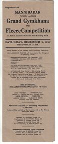 Linton and District Historical Society Inc
Programme, Mannibadar Twelfth Annual Grand Gymkhana and Fleece Competition, 1959
Single sheet of brown cardboard folded in three lengthwise. Programme for Mannibadar gymkhana and fleece show held Saturday, December 5th, 1959, in aid of Soldiers' Memorial Hall Building Fund.Text: " MANNIBADAR / TWELFTH ANNUAL / Grand Gymkhana / AND / Fleece Competition / In Aid of Soldiers' Memorial Hall Building Fund. "mannibadar grand gymkhana and fleece competition, programmes -
 Port Fairy Historical Society Museum and Archives
Photograph, Formerly 1858 Telegraph Office
This building housed the Telegraph Office circa 1858 now a private residenceColoured photograph of bluestone buildinggovernment, building, cox street -
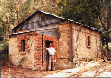 Stawell Historical Society Inc
Photograph, Heatherlie Quarry with Geoff Sudholz standing in doorway of the stone building -- Coloured
Heatherlie Quarry colour photo of stone building. Geoff Sudholz standing in doorway.Coloured Photograph of GeoffSudholtz standing in a doorway of a stone building with an iron roof in a bushland setting. Building is at Heatherlie Quarrystawell grampians industry -
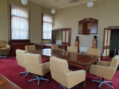 Federation University Historical Collection
Photograph, Clare Gervasoni, Ballarat School of Mines Founders Room (A Buliding), 04/11/2019
Founders Room was disbanded in late 2019 in preparation for a building refurbishment.A number of photos showing the Ballarat School of Mines Founders room, and furniture before it was cleared for the refurbishment of the Administration Building (A Building)administration building, a building, cedar tables, council table, council room, founders room, alfred mica smith, dick richards -
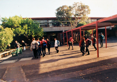 Williamstown High School
1990 - Architecture
3 colour photographs of school buildings mounted on board. Accompanied by a caption.Caption reads: When people visit W.H.S. they remark on the mixture of architecture which spans over one hundred years, single and double storeys, rendered brick, red brick and grey brick buildings.williamstown high school, 1990, architecture -
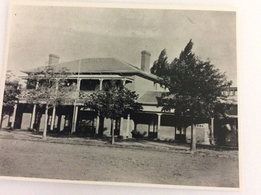 Port of Echuca
A black and white photograph, The Bridge Hotel, in 1896, showing Silky Oak trees, 1970's
The Bridge Hotel was built by Henry Hopwood to house visitors to the town crossing the Murray River on his punt crossing, which was situated just below the Bridge Hotel on the Murray River. The accommodation was spacious and grand! In the right back corner of the photograph, the 'lantern' roof of the St Georges Hall can be seen. The street is level with the front entrance to the Hotel, which is very different to what it is today.The photograph shows hotel activities and accommodation in the late 19th Century.A black and white photograph of the Bridge Hotel taken from the Hopwood Gardens. The photograph shows four silky oak trees growing along the front of the building. There is an empty flag pole outside the front of the building. The right wing advertises billiards, whilst the left wing apparently was a bar.Written on the building can be seen the words; HOTEL and BILLIARDS. Written in pen on the back of the photograph are the words "Bridge Hotel. Probably 1896, showing Silky Oak trees.bridge hotel, henry hopwood, silky oak trees, lantern roof, st georges hotel -
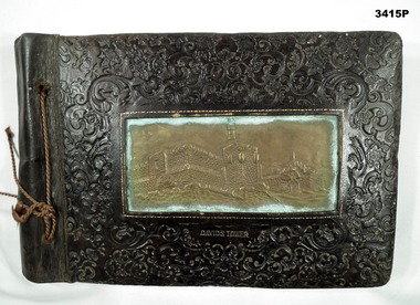 Bendigo Military Museum
Album - ALBUM, PHOTOGRAPH, C. WWII
Hard brown leather cover, heavily carved with floral shapes. Rectangular brass panel in center of cover showing a building stamped in the leather. String binder. Photos are mounted on black cardboard sheets. White handwriting is underneath each photo. Subjects include Bethlehem, natives, Mosour, water colour painting of aircraft landing & native with pipe, Jerusalem, Jordan River, Petra, Jerusalem war cemetery, Tiberias, the stations of the cross, Australian troups & 1000 lb bomb, post battle scenes, German war dead, tanks, enemy aircraft, probably captured German soldiers, POWs Greece, Baalbek, Syria, Jaffa, Damascus, address by General Alexander to AIF, post El Alamein.Underneath building front cover: “Davids Tower”photograph, album, alamein, pow’s -
 Kew Historical Society Inc
Plan, Melbourne & Metropolitan Board of Works : Borough of Kew : Detail Plan No.1578, 1904
The Melbourne and Metropolitan Board of Works (MMBW) plans were produced from the 1890s to the 1950s. They were crucial to the design and development of Melbourne's sewerage and drainage system. The plans, at a scale of 40 feet to 1 inch (1:480), provide a detailed historical record of Melbourne streetscapes and environmental features. Each plan covers one or two street blocks (roughly six streets), showing details of buildings, including garden layouts and ownership boundaries, and features such as laneways, drains, bridges, parks, municipal boundaries and other prominent landmarks as they existed at the time each plan was produced. (Source: State Library of Victoria). This plan forms part of a large group of MMBW plans and maps that was donated to the Society by the Mr Poulter, City Engineer of the City of Kew in 1989. Within this collection, thirty-five hand-coloured plans, backed with linen, are of statewide significance as they include annotations that provide details of construction materials used in buildings in the first decade of the 20th century as well as additional information about land ownership and usage. The copies in the Public Record Office Victoria and the State Library of Victoria are monochrome versions which do not denote building materials so that the maps in this collection are invaluable and unique tools for researchers and heritage consultants. A number of the plans are not held in the collection of the State Library of Victoria so they have the additional attribute of rarity.Original survey plan, issued by the MMBW to a contractor with responsibility for constructing sewers in the area identified on the plan within the Borough of Kew. The plan was at some stage hand-coloured, possibly by the contractor, but more likely by officers working in the Engineering Department of the Borough and later Town, then City of Kew. The hand-coloured sections of buildings on the plan were used to denote masonry or brick constructions (pink), weatherboard constructions (yellow), and public buildings (grey). MMBW Plan No.1578 is significant in that it defines the extent of two private schools: Xavier College and Kew High School (now part of Trinity Grammar) by 1904. In relation to the latter, the plan clarifies which buildings the High School operated from behind the mansion ‘Molina’. Established in 1902, Trinity Grammar was to later lease and subsequently buy Molina (now ‘Merritt House’) and ‘Elsinore’ (now ‘Roberts House’). Xavier College had been established in 1872. This 1904 plan delineates the West Wing and the Great Hall (built in 1890).melbourne and metropolitan board of works, detail plans, maps - borough of kew, mmbw 1578, cartography -
 Tatura Irrigation & Wartime Camps Museum
Plaque, 1961
Large brass plaque commemorating the opening of a State Rivers and Water Supply Commission building in Carnegie by the Premier in 1961SRWSC, This building was officially opened on September 14th 1961 by the Hon H.E Bolte MLA Premier of Victoria and the Hon W.J. Mibus MLA Minister of Water Supply -
 Kew Historical Society Inc
Plan, Melbourne & Metropolitan Board of Works : Borough of Kew : Detail Plan No.1571, 1904
The Melbourne and Metropolitan Board of Works (MMBW) plans were produced from the 1890s to the 1950s. They were crucial to the design and development of Melbourne's sewerage and drainage system. The plans, at a scale of 40 feet to 1 inch (1:480), provide a detailed historical record of Melbourne streetscapes and environmental features. Each plan covers one or two street blocks (roughly six streets), showing details of buildings, including garden layouts and ownership boundaries, and features such as laneways, drains, bridges, parks, municipal boundaries and other prominent landmarks as they existed at the time each plan was produced. (Source: State Library of Victoria)This plan forms part of a large group of MMBW plans and maps that was donated to the Society by the Mr Poulter, City Engineer of the City of Kew in 1989. Within this collection, thirty-five hand-coloured plans, backed with linen, are of statewide significance as they include annotations that provide details of construction materials used in buildings in the first decade of the 20th century as well as additional information about land ownership and usage. The copies in the Public Record Office Victoria and the State Library of Victoria are monochrome versions which do not denote building materials so that the maps in this collection are invaluable and unique tools for researchers and heritage consultants. A number of the plans are not held in the collection of the State Library of Victoria so they have the additional attribute of rarity.Digital copy of the original survey plan, issued by the MMBW to a contractor with responsibility for constructing sewers in the area identified on the plan within the Borough of Kew. The plan was at some stage hand-coloured, possibly by the contractor, but more likely by officers working in the Engineering Department of the Borough and later Town, then City of Kew. The hand-coloured sections of buildings on the plan were used to denote masonry or brick constructions (pink), weatherboard constructions (yellow), and public buildings (grey). This plan is part of a large and historically significant group of MMBW plans and maps that was donated to the Society by the Mr Poulter, City Engineer of the City of Kew in 1989. When the contracts were let for surveyors to identify and record the extant houses and landscapes within an area for the Board of Works, the contracts were let at separate times, hence the anomaly where two copies of Plan No.1571 exist in our collection. The first of these plans identifies the building materials used in houses bordering Fitzwilliam Street, Edgevale Road, May Street, Malin Street, Davis Street and Wellington Street. The cut off point for the survey was the south side of Wellington Street. By 1903 when the survey was undertaken many of the sites were already built on, particularly those facing Edgevale Road. The plan identifies the preponderance of weatherboard houses in the area. The other version of the plan identifies the buildings between Wellington Street and Cotham Road.melbourne and metropolitan board of works, detail plans, mmbw 1571, cartography -
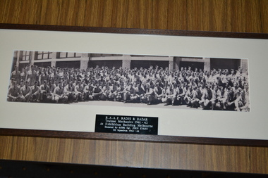 Wangaratta RSL Sub Branch
Photograph - Framed photograph, Wangaratta Picture Framers
Image of RAAF Radio & Radar Trainee Mechanics taken at the Exhibition Building, Melbourne in 1941-42. In 1940, in the months after the outbreak of WWII, the Exhibition Buildings complex was requisitioned by the Royal Australian Air Force and used as a barracks and training facility. By 1942 more than 2000 men of the RAAF had been stationed there, alongside members of the Women’s Auxiliary Australian Air Force.Brown timber frame and cream coloured mount containing photograph of large group of airmen Plaque -RAAF Radio & Radar Trainee Mechanics 1941-42 at Exhibition Building Melbourneraaf, radio & radar, exhibition building, melbourne, ww2 -
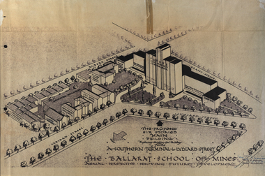 Federation University Historical Collection
Plan, Ballarat School of Mines Future Development: A Southern Terminal to Lydiard Street, 1947, 09/12/1947
... buildings ...In 1947 Percy Everett, Chief Architect for the Victorian Government, drew up plans to accomodate the growth in student numbers on the Ballarat School of Mines site. It was an era of government buildings surrounding the Ballarat School of Mines campus either being transfered to the school or foreshadowed for transfer. In 1947 two Red Cross huts were transferred from Victoria Park to the western side of the former Ballarat Supreme Court (later Courthouse Theatre) for use by Wool Classing and Motor Mechanics. In the same year additional facilities were provided for Pottery due to the increase in enrolments and a large brick classroom was built at the rear of the Ballarat Junior Technical School Building. In the annual report of 1947 the President said: "These transfers are, however, only temporary expedients and indicate the pressing need for more buildings of a permanent nature". By the end of the year the School Council decided to request the Education Department of Victoria to proceed with the implementation of the School's long-range plan whch had received approval earlier and to treat it as an urgent post-war requirement. After much communication a plan for a six-storied building, flanked by two three storied buildings was planned to be built on the site of the Ballarat Gaol was developed. The plan was sent to the Education Department for the Minister's Approval. It is not know if approval was granted, but the building did not proceed, possibly becausse the Ballarat Gaol was still very miuch in use. When a tertiary division of the Ballarat School of Mines was being developed in 1967 it corresponded with the closure of the Ballarat Gaol. It was determined that the Lydiard Street South site had no room for future growth so a new campus was sought. The new campus was purchased at Mt Helen, and was initially known as the Ballarat Insittute of Advanced Education. In 1976, when the Ballarat Teachers' College merged into the structure, the campus became known as the Ballarat College of Advanced Education and it was no longer a part of the Ballarat School of Mines. Plans for a proposed building to replace the Ballarat Gaol buildings. The proposed building was never built, the concept being replaced by a new teritary facility at Mt Helen. buildings, percy everett, ballarat school of mines battery, ballarat technical art school, engineering workshops, machine shop, ballarat junior technical school, architectural plans, ballarat school of mines, smb campus -
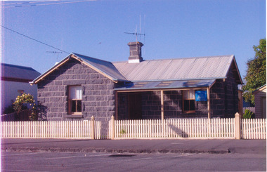
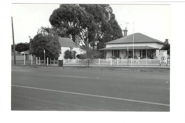
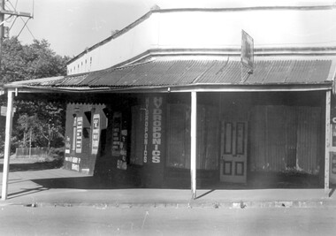 Surrey Hills Historical Society Collection
Photograph, 109 Union Road, Surrey Hills after fire damage
This building was damaged by fire and was subsequently demolished before June 1983. From 1901-1917 it was the site of the Surrey Hills Post Office. In later years the part of the building with frontage to Windsor Crescent was used as the dental surgery of Dr David Ellis; the Union Road part of the building was occupied by a barber and tobacconist for many years. At the time of the fire the building was used by a business supplying hydroponics requirements. This moved to (?) 119 Highbury Road, Burwood.The image is significant because it documents a building which was an important community facility which no longer exists.Black and white photo of a single-storey corner building with a corrugated iron roofed veranda and a single, 4-panel timber door. There is a sign with '109' mounted on the veranda of the building. There are multiple advertising signs on the walls of the building. Two of the windows are boarded up with corrugated iron sheets.shops, barber shops, tobacconists, surrey hills post office, dentists, union road, windsor crescent, hydroponics supplies, businesses, union road shops, dr david ellis -
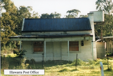 Stawell Historical Society Inc
Photograph, Post Office at Illawarra 1960's -- Coloured
Colour photo of timber building used as Illawarra Post Office during the c 1960's.Coloured photo of timber building with corrugated iron roof and verandah. Tank stand behind building and trees in the background.Illawarra Post Office stawell -
 Kew Historical Society Inc
Photograph - Hawthorn Tram Depot during construction, 1915
One of a series of photographs, taken by Edgar James Dower in the second decade of the twentieth century. Born and raised in Olinda, his family later moved to Surrey Hills. He worked as an adult as a clerk in the city office of the Metropolitan Gas Company, and in his role as a 'collector', he was able to photograph scenes including the construction of tramlines and associated buildings in Kew, Hawthorn, Camberwell and Surrey Hills. Later he established a real estate agency with his brother - the E.J. Dower Real Estate Agency, Dandenong Office.The image is an historically significant record of the development of transport infrastructure which was used to connect Victorians in the first two decades of the twentieth century. This development resulted from increases in population and the consequent extension of Melbourne's suburbs. The photographs, both individually and collectively, richly detail the labour of workers and the tools and machinery used to create and extend Melbourne's tram network in the years preceding and during World War 1.Two faded original horizontal photographs, mounted on vertical card showing external and internal features of the Hawthorn Tram Depot during its construction phase. The top photo shows a panoramic view of the exterior while the second photo shows workers posed within the building.Recto: "The tramways building in course of creation. C/r of Power St & Wallen Road, Hawthorn. Showing one of the original horse drawn trams which ran from Hawthorn Bridge to Auburn Road".. theme --- travelling by tram, theme -- connecting victorians by transport and communications, tramways -- hawthorn -
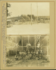
University of Melbourne, Burnley Campus Archives
Photograph - Black and white print, 703/3, 24 July 1948
24/7/48. "The new building rises to displace the Old Pavilion which is soon to be demolished." "The new building is nearly finished." THK"24/7/48". Administration Building under construction.administration building, construction, e. m. gibson collection -
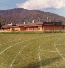 Kiewa Valley Historical Society
Photos - Mt Beauty Buildings in 1973. Set of 8, 1973
The shopping centre in Mt Beauty, both buildings and streetscape, have undergone significant changes since 1973. The kindergarten has undergone extensive remodelling, The Chalet has been replaced by Svarmisk Resort and Accommodation Spa. Tawonga hospital has undergone extensive renovation and is now Mt Beauty Hospital AND Kiewa Valley House. The Workman’s Club changed name to the Country Club and has since closed down. Hospital and Kiewa Valley House now occupy what is shown as a vacant lot opposite the motel which is now called Mt Beauty Motor Inn.The houses in Mt Beauty were brought in by the State Electricity Commission of Victoria when they constructed Mt Beauty Town for their workers building the Kiewa Hydro Electric Scheme. Mt Beauty is unique began as a construction town in the late 1940's.Colour photographs of various buildings in Mt Beauty taken in 1973 1. Workman’s Club 2. View over the pondage 3. Tawonga Hospital (Mt Beauty) 4. Mt Beauty Chalet 5. Mt Beauty Kindergarten 6. The Merjei Motel 7. 8 Valley Avenue 8. Shopping Centre Handwritten in ink on the back of photos 1. Workman’s Club 1973 (after the brick makeover) From the sports oval – the high school is to the right 2. A view over the pond 1973 3. Tawonga Hospital 1973 (Mt Beauty) 4. Mount Beauty Chalet 1973 5. Kindergarten 1973 6. The Merjei Motel 1973 7. Our house at 8 Valley Ave 1973, Owner after us erected the car port, let the front hedge run amok and vanquished the vegetable garden and citrus trees Dad created. 8. Shopping Centre 1973. At the end of the street is the hospital (believe it is now Mt Beauty Bush Nursing Hotel) mt beauty, workman's club, chalet, tawonga hospital -
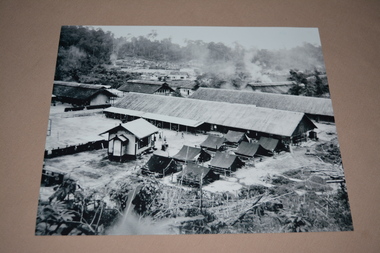 Wangaratta RSL Sub Branch
Photograph
Image appears to be of Army camp based near/at rural village with outlying buildings on Tarakan Island The 2/24th Battalion was an infantry battalion of the Australian Army, which served during World War II .A unit of all-volunteers, it was formed in July 1940 from primarily Victorian volunteers and was known as "Wangaratta's Own" because of the time the battalion spent in the town during its formative period prior to deployment overseas. It served in North Africa in 1941–1942 as part of the 26th Brigade, which was assigned to the 7th Division, before being reassigned to the 9th Division. In early 1943, the battalion returned to Australia and later took part in campaigns against the Japanese in New Guinea in 1943–1944 and Borneo in 1945, before being disbanded in 1946. The 2/24th suffered the highest number of casualties of any 2nd AIF infantry battalion. The Unit was granted the Freedom of the City by the Rural City of Wangaratta in 1996 and one of the first, if not the first, to receive this type of honour. Reproduced black and white photograph of two rows of long buildings with four men between one small building and two rows of tent like structures in the foreground. There are small buildings and smoke rising in the background.On rear - Boxing ring on Tarakan2/24th battalion, tarakan, ww2 -
 Buninyong & District Historical Society
Photograph - B/W photograph, Mr. C. J. Brooks, Former Middleton's Hardware Shop Warrenheip Street Buninyong and residence, 19th April 1994
1994 photograph of early well known Hardware shop and residence associated with the Middleton family.Example of an early weatherboard shop and residence operated by a local familyBlack and white photograph of streetscape, West side of Warrenheip Street North showing weatherboard residence and hardware shop associated with the Middleton familymiddleton family, warrenheip street, hardware shop, building, streetscape, ironmongery, weatherboard, local business -
Canterbury History Group
Ephemera - "Winson" 1 Winson Green Road Canterbury, 1989
Real Estate advertisement for the sale of "Winson' 1 Winson Green Road Canterbury. Includes coloured photographs of the streetscape and interior and exterior of the house.canterbury, winson green road, winson, paul walker & assoc. pty ltd, woodwards, first national -
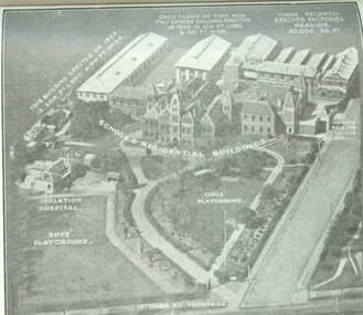 Vision Australia
Photograph - Image, Aerial view of the Royal Victorian Institute for the Blind grounds in St Kilda Road, 1927
... Buildings ...Aerial photo of the RVIB St Kilda Road buildings and grounds, scanned from an unknown printed source. On the image are written descriptions of buildings, including the width and length of those erected in 1920's, the isolation hospital and the segregation of boys and girls playing areas. 1 scanned image of RVIB St Kilda Road from airGirls playground School & residential buildings Boys playground Isolation hospital This building, erected in 1926 - is 200 ft long & 40 ft wide Each floor of this new two storied building erected in 1926 is 100 ft long & 40 ft wide These recently erected factories measure 20,000 sq ft Ormond Hall for socials, etc. St Kilda Road frontageroyal victorian institute for the blind, buildings -
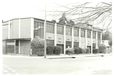 Federation University Historical Collection
Photograph, Ballarat School of Mines Corbould Building, 1986, 1996
The Corbould Building is located on the corner of Grant Street and Albert Street, Ballarat.Black and white photography of a double storey brick building known as the Ballarat School of Mines Corbould Building. It houses automotive studies. ballarat school of mines, corbould, corbould building, automotive, corbould recreation hall -
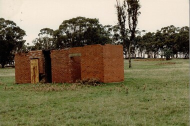 Tatura Irrigation & Wartime Camps Museum
Photograph, Camp 1 prison, 1989
The building is the remains of the prison at Camp 1. Foam backed copy in file.Coloured photograph. Red brick building in foreground. To left of building there is a wooden door. Two other doorways, no doors, flat roof.camp 1, tatura victoria, camp goals, camp building remains -
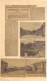 Ringwood and District Historical Society
Newspaper - Clipping, The Age, Namesake Towns: Images of Ringwood Hampshire England and Ringwood Victoria. From 'The Age' 4 April 1931, 4-Apr-31
Article as part of a series comparing Ringwood, Hampshire, England and Ringwood, Vic.. Population details, industry, houses and environs. 4 B&W pictures two of Ringwood ,England and two of Ringwood , Vic. depicting streetscapes and buildings.Newspaper cuttings on cream coloured cardboard from 'The Age' 4 April 1931 with 2 B&W photos of Ringwood, Hampshire, England and 2 B&W photos of Ringwood ,Victoria ,Clocktower in background and old Town Hall. Printed text. -
 Federation University Historical Collection
Photograph, Bill Durant, Ballarat Institute of Advanced Education Physics Building, 02/1974
... buildings ...The physics building was one of the early buildings built on Mt Helen campusColour transparency of Mt Helen Campus S Building under constructionbuildings, physics, bill durant