Showing 1834 items
matching inches
-
 Bendigo Military Museum
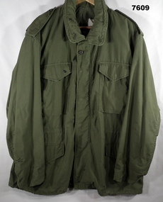
Uniform - COAT, ARMY FIELD, WINTER, Australian Defence Industries, C.1960's
Uniform in the collection re “M. ANGUS" 6 RAR Vietnam. Refer Cat. No. 669. Coat - green colour cotton twill fabric with green plastic buttons, front metal zipper and metal press studs. Collar, shoulder epaulettes, four front pockets with metal stud closure flaps, green cotton lining throughout garment. Collar with concealed hood with zipper closer. Hood and waist draw strings. White cotton manufacturers label inside back below collar.Manufacturers label with black ink print. "LARGE REGULAR/ Chest from 41 to 45 inches/ Height from 67 to 71 inches/ Stock No. 8415-782-2942/ COAT, COLD WEATHER, MAN'S FIELD/ P.O. 51365-C-647005/ JHN OWNBEY COMPANY INC."uniform, army coat, m.angus -
 Flagstaff Hill Maritime Museum and Village
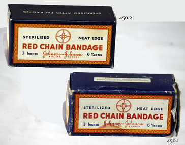
Equipment - Ribbon Gauze & Box, Johnson & Johnson Pty Ltd
Most surgical wounds are closed primarily, but some are allowed to heal by secondary intention. This usually involves repeated packing and dressing of the raw wound surfaces. Although the long-term care of such wounds has devolved to the care of nurses in the community or out-patient setting, the initial wound dressing or cavity packing is done by the surgeon in the operating theatre. Many surgeons are unaware of the growth of the discipline of wound care, and still use traditional soaked gauze for dressing and packing open surgical wounds and cavities. https://www.ncbi.nlm.nih.gov/pmc/articles/PMC1963638/The control of bleeding and wound management is vitally important for the survival of the patient.Gauze bandage and cardboard box.Two boxes. One box in better condition. Red Chain Bandage. Johnson and Johnson Pty Ltd Sydney. 3 inches, 6 yards. Sterilized neat edge.flagstaff hill, warrnambool, shipwrecked-coast, flagstaff-hill, flagstaff-hill-maritime-museum, maritime-museum, shipwreck-coast, flagstaff-hill-maritime-village, "red chain bandage", gauze, bandage, johnson & johnson -
 Warrnambool and District Historical Society Inc.
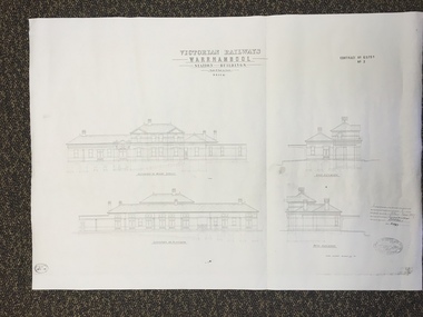
Map, Victorian Railway W'bool No1 & No2, 1897
These two sheets show the 1897 plans drawn up by the Victorian Railways for the erection of the Warrnambool Railway Station building. It is a two-storey building still existing today. The railway came to Warrnambool in 1890 and they must have used temporary buildings for seven years before this railway building was erected. It had offices, booking counter and public facilities on the ground floor and housing for the Station Master on the first floor. The building erected was a typical design for country town railway stations and many of similar design were erected in the 1880s and 90s. These plans are important because they show clearly the design of the Warrnambool Railway Station buildings when they were first erected in the 1890s.They will be very useful for researchers. The coming of the railway was a significant event in Warrnambool’s history and did much to make the port and shipping a less viable proposition.These are two architect’s plans and drawings of the Warrnambool Railway Station building (1897). The drawings are black and white and the first plan shows the ground floor plan and the first floor plan and the outbuildings. The second plan shows drawings of the building with its elevation to the platform and its elevation to Merri Street. There are two stamps of the Railways Department, Melbourne. These are copies, not originals. ‘Victorian Railways, Warrnambool, Station Buildings, Scale 8 feet to one inch, Contract No. 6379B (Nos. 1 and 2)’warrnambool, railway station buildings -
 Halls Gap & Grampians Historical Society
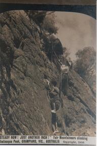
Photograph - Sepia, c 1909
Photo is probably a tourist shot for advertising activities in the Grampians. Climbing area is somewhere around Chatauqua Peak. Photo shows two women and a boy attempting to climb a section of rock. The women are dressed in blouses and long skirts and are holding on to a rope. one is wearing a hat. the boy is wearing a cap and is barefoot.'Steady Now! Just Another Inch' Fair Mountaineers climbig Chatauqua Peak, Grampians,Vic, Australia. Copyright 1909.recreation, rock climbing -
 Ringwood and District Historical Society
Map - State Aerial Survey, Dandenong Ranges Area Sheet 7, Parishes of Warrandyte, Scoresby, Ringwood and Nunawading - 1956
Map of central and southern areas of Ringwood and part of Ringwood East and Heathmont compiled by Dept of Lands and Survey, July 1956, from aerial photographs and Cadastral Survey information. Subsequent coloured hand-drawn additions showing layout of a number of post-NSW Separation era proposed subdivisions that did not eventuate, including Village of Studley Estate, Township of East Kew Estate, Township of Ballyduffy Estate, Township of New Flemington Estate, Township of East Hawthorne Estate. Ringwood A4B2, 849 A4B Zone 7. Scale: 10 chains to 1 inch. Contour interval 20 feet. -
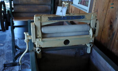 City of Moorabbin Historical Society (Operating the Box Cottage Museum)
Functional object - Laundry Eqipment , 'ACME' clothes wringer, mid 20thC
This ACME portable clothes wringer could be attached to a wash trough or hand washing machine to remove excess water from the washing. It was much less cumbersome that the earlier Mangles used for this purposeMost homes of 20th C in City of Moorabbin would have had one of these ACME wringers . It greatly eased the washday burden of the women. The Exchange Hotel Nepean Highway Cheltenham was a well established meeting place for Moorabbin Shire settlers by 1915A metal clothes wringer with side hand crank and 2 rollers that could be attached by screw clamps to a wash trough or washing machine for removing excess water from washing. The pressure of 2 rollers was controlled by a screw on the top of machine that could be loosened or tightened according to the material being passed through.ACME 14 INCH / on hand crank is list of patents for Great Britain, USA, Aust. NZ, Germany, Belgium, Sweden moorabbin, bentleigh, cheltenham, laundry equipment, washing, washing mangles, washing machines -
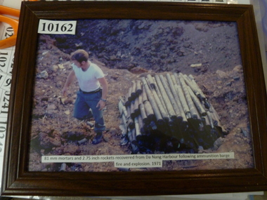 National Vietnam Veterans Museum (NVVM)
Photograph, 81mm mortarts and 2.75 inch rockets recovered from Dan Nang harbour after ammunition barge fire 1971
81mm mortarts and 2.75 inch rockets recovered from Dan Nang harbour after ammunition barge fire 1971photograph., rockets, mortars -
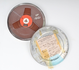 Melbourne Legacy
Film, Anzac Day Ceremony for Schools 1970
A Legacy ceremony at the Shrine of Remembrance in 1970. One of the annual "Anzac Commemoration Ceremony for Students" events, held just prior to ANZAC Day. The ceremony provides a valuable opportunity for students to gain an appreciation of the Anzac spirit, the significance of the Shrine and the meaning of Anzac Day. The school ceremony was broadcast on ABC TV and Radio for many years. Pencilled note on cannister lid- “Sir Edward Dunlop”. AKA “Weary”. Maybe he is part of the recording.A record of the promotion and importance of Anzac Day Ceremony for schools. “Weary” of Burma Railway Fame.Cannister metal, colour silver, Spool, plastic, magnetic tapeAustralian Broadcasting Commission, Length28feet 10 inches, Replay Date Fri 24 ? At 3AR (radio station), 1415 AETanzac commemoration for students, dunlop -
 Kew Historical Society Inc
Slide - Architectural Drawing, Kew Public Offices, 1887
A civic campaign for new public offices developed in Kew in the 1880s. After much deliberation, the location chosen was the junction of Bulleen and Cotham Roads. The buildings were designed by George Watson and John Henry Harvey, architects within the Department of Public Works (Victoria). Building was commenced in 1887, and after one year, the buildings were opened. The Post Office was transferred to the new Commonwealth Government in 1901. The Police Station and Court House, sold by the Victorian Government to the City of Boroondara in 2007, are now a community cultural centre and performing arts venue.The buildings were listed on the Victorian Heritage Register Register (HO885) in 1991. They are historically and architecturally significant to the State Of Victoria because Watson and Harvey's designs exhibit diversity in integrating civil offices, they accommodate the apex of road junctions, and they demonstrate a departure from the contemporaneously favoured High Victorian Classical to the Queen Anne style in the design of civic buildings. 35mm colour transparency of an original plan by George Watson and John Henry Harvey, architects of the Department of Public Works (Victoria), in 1887 for New Public Offices at Kew. This plan was copied by the donor from an original held at the Commonwealth Archives in Brighton (Vic). The copy was made to illustrate a report that the donor made on ‘The functional planning design, building materials and construction methods of the Kew Post Office’ as part of course work at RMIT.NEW PUBLIC OFFICES KEW/ FIRST FLOOR & ROOF PLAN / DRAWING NO 1 / SCALE 8 FEET TO ONE INCHkew court house, kew police station, kew post office, architectural drawings, khs - slides, new public offices -- kew (vic.), architecture — queen anne style -
 National Wool Museum
Booklet - Albany Knitting, Albanella Crochet, Albany Woollen Mills
Four page paper fold out brochure with colour photograph on the front and printed black text on other pages. Image shows a woman wearing a pink short sleeved jumper with a cat on her lap.front: [printed] PRICE / 3d. / ALBANY / Knitting / Albanella Crochet / BUST 32-36 inches / 4-5 ozsknitting, pattern, fashion, knitwear, albany woollen mills -
 Port Melbourne Historical & Preservation Society
Photograph - Nine inch reticulation pipes at Port Melbourne, "Melbourne water supply", 1890s
Three black and white images taken from: "Melbourne water supply - sewerage schemes" Special edition of the "Building, engineering and mining journal" The operations of the Melbourne and Metropolitan Board of Works. (.01) Plate XXVIII . Nine inch reticulation pipes at Port Melbourne, showing how the trenches in this sandy soil had to be timbered. Four inch junctions for house connections are also shown.engineering - board of works, built environment - civic, mmbw, sewer, melbourne and metropolitan board of works -
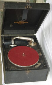 Greensborough Historical Society
Domestic object - Gramophone, Columbia, Columbia Viva-tonal Grafonola, 1920c
This wind-up portable gramophone, for 78 rpm discs, was used for home entertainment. It did not require electric power. Includes one record.Wind-up portable gramophone, for 78 rpm discs, in black leatherette box, with needles and 10 inch (25 cm) 78 rpm acetate discColumbia Viva-tonal Grafonola Made in Australiagramophones, phonographs, audio equipment, gramophone records -
4th/19th Prince of Wales's Light Horse Regiment Unit History Room
Booklet (2 copies), Infantry Training Vol 1 Infantry Platoon Weapons Pam 5 Pistols, 1966
A soft covered booklet providing instructors with the necessary information to train soldiers to handle and fire the 9 mm self loading pistol and the .38 inch revolver.7160-66-024-7171pistol, 9mm, .38 inch revolver -
 Eltham District Historical Society Inc
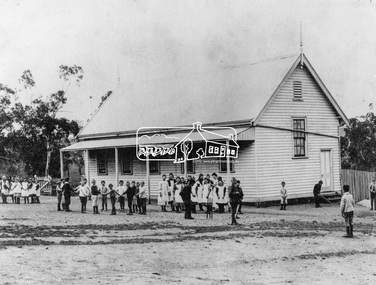
Photograph, Kangaroo Ground State School, c.1900
Built c.1876, the site was purchased in 1874. Reproduced on p25 of 'Pioneers & Painters'This photo forms part of a collection of photographs gathered by the Shire of Eltham for their centenary project book,"Pioneers and Painters: 100 years of the Shire of Eltham" by Alan Marshall (1971). The collection of over 500 images is held in partnership between Eltham District Historical Society and Yarra Plenty Regional Library (Eltham Library) and is now formally known as the 'The Shire of Eltham Pioneers Photograph Collection.' It is significant in being the first community sourced collection representing the places and people of the Shire's first one hundred years.Digital image 4 x 5 inch B&W Neg Print (2) 20 x 25 cm and 9 x 12.5 cmshire of eltham pioneers photograph collection, kangaroo ground, kangaroo ground state school, pioneers and painters -
 Eltham District Historical Society Inc
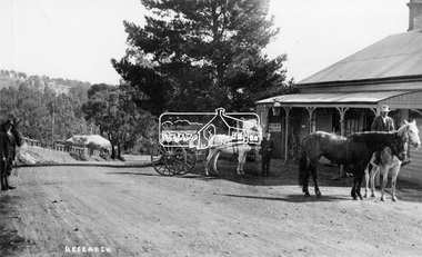
Negative - Photograph, Tom Prior (prob.), West's Research Hotel, Main Road, Research, c.1907
West's Research Hotel, Main Road, Research, near site of present pre-school centre. General Store on left. (Destroyed by fire 1931) Note sign for State Electoral Halls. Most likely taken on Election Day 1907 by Tom Prior, who also took the Election Day photos in Eltham near the Eltham Hotel. This photo forms part of a collection of photographs gathered by the Shire of Eltham for their centenary project book,"Pioneers and Painters: 100 years of the Shire of Eltham" by Alan Marshall (1971). The collection of over 500 images is held in partnership between Eltham District Historical Society and Yarra Plenty Regional Library (Eltham Library) and is now formally known as the 'The Shire of Eltham Pioneers Photograph Collection.' It is significant in being the first community sourced collection representing the places and people of the Shire's first one hundred years.Digital image "4 x 5 inch B&W Neg 120 format B&W negative" Print 15.5 x 25.5 cmshire of eltham pioneers photograph collection, research (vic.), research hotel, general store -
 Bendigo Historical Society Inc.
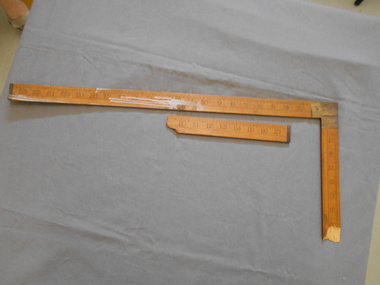
Tool - PITTOCK COLLECTION: TIMBER & BRASS MEASURING / SET SQUARE
Timber & Brass Measuring / Set Square Light timber legs with brass reinforced corner construction Measurements in inches along both legs of the set squareJ. Rabone & Sons Birmingham No 1535 -
 Bendigo Historical Society Inc.
Map - JACK FLYNN COLLECTION: KARA KARA, 1932
Map: County of Kara Kara, map sheet showing the whole of the County of Kara Kara and all of the Parishes within. Scale 2 miles to 1 inch.By Authority: W.M. Houston, Government Printer Melbourne. Department of Lands and Survey, Melbourne, 1958map, kara kara, county, kara kara -
 Peterborough History Group
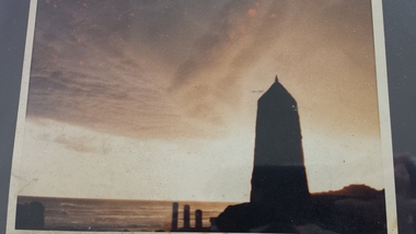
Photograph - James Irvine Memorial
Photograph of the Memorial to James Irvine, Hotel Proprietor, who drowned whilst crossing the Curdies River. The Memorial was erected by the towns people.Significant because it is a memorial to a respected notable resident of the town who tragically drowned crossing the Curdies River 4 x 6 inch sepia photograph of the sunset with James Irvine Memorial in the foreground. Date unknown but appears to be taken prior to footpath and fencing renovations.curdies river, james irvine, peterborough, james irvine memorial -
Yarrawonga and Mulwala Pioneer Museum
Nails
4 inch Hand made iron nails. Used in a cabin trunk which came to Australia on the "Cluthe" with Mrs J Mc Luchie in October 1860 -
 Whitehorse Historical Society Inc.
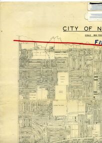
Legal record - Map, F19 freeway, 1/12/1977 12:00:00 AM
Approximate alignments of F19(Eastern) Freeway, F9 and Scoresby Freeway, marked on 1973 edition of City of Nunawading map,Approximate alignments of F19(Eastern) Freeway, F9 and Scoresby Freeway, marked on 1973 edition of City of Nunawading map, Scale 800 ft = 1 inch.Approximate alignments of F19(Eastern) Freeway, F9 and Scoresby Freeway, marked on 1973 edition of City of Nunawading map, freeways, city of nunawading, eastern freeway, scoresby freeway -
 Bendigo Historical Society Inc.
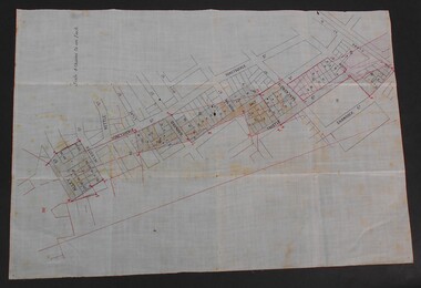
Document - WES HARRY COLLETION: SURVEORS MAP ON LINEN OF HONEySUCKLE AND THISTLE STREETS
A surveyor's map to scale 4 chains to 1 inch of Honeysuckle & Thistle Streets, between Alley Street and Clark Street Unknown purpose of the plan - undated -
 Flagstaff Hill Maritime Museum and Village
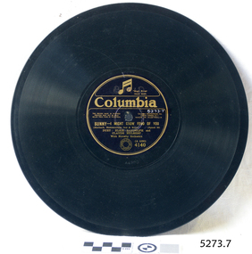
Audio - Gramophone Record
Bakelite record by Columbia A4290. "SUNNY I Might Grow Fond Of You." Duet Elsie Randolph and Claude Hulbert Size: 10 inch recordflagstaff hill, warrnambool, shipwrecked-coast, flagstaff-hill, flagstaff-hill-maritime-museum, maritime-museum, shipwreck-coast, flagstaff-hill-maritime-village -
 Flagstaff Hill Maritime Museum and Village
Audio - Gramophone Record
Bakelite record by Columbia A454 0625 "Oh, If Only I Had You" Sung by Jack Lumsdaine (The Radio Rascal) Size: 10 inch recordflagstaff hill, warrnambool, shipwrecked-coast, flagstaff-hill, flagstaff-hill-maritime-museum, maritime-museum, shipwreck-coast, flagstaff-hill-maritime-village -
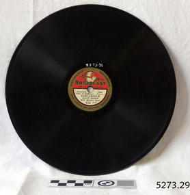
 Flagstaff Hill Maritime Museum and Village
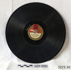
Audio - Gramophone Record
Bakelite record, Electrically Recorded, The Long Playing Record Broadcast A193 "Dancing Tamborine" by Harry Bidgood and his Broadcasters. Size: 8 inch record.flagstaff hill, warrnambool, shipwrecked-coast, flagstaff-hill, flagstaff-hill-maritime-museum, maritime-museum, shipwreck-coast, flagstaff-hill-maritime-village -
 Flagstaff Hill Maritime Museum and Village
Audio - Gramophone Record
Bakelite record, Electrically Recorded, The Long Playing Record Broadcast A152 "Barcarole" by Teddy Brown with his Military Band. Size: 9 inch record.flagstaff hill, warrnambool, shipwrecked-coast, flagstaff-hill, flagstaff-hill-maritime-museum, maritime-museum, shipwreck-coast, flagstaff-hill-maritime-village -
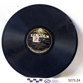 Flagstaff Hill Maritime Museum and Village
Audio - Gramophone Record
Bakelite record by The Lincoln Record Corporation N.Y. 2103 "I've Got A song For Sale" by Beale Street Five No 652 Size: 10 inch record.flagstaff hill, warrnambool, shipwrecked-coast, flagstaff-hill, flagstaff-hill-maritime-museum, maritime-museum, shipwreck-coast, flagstaff-hill-maritime-village -
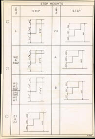 Melbourne Tram Museum
Drawing, The Met, "Step Heights", c1984
Drawing - A2 sheet, "Step Heights", listing all vehicles in use c1984, including A and B class data in both inches and mm. Drawing No. X1540.trams, tramways, drawings, tramcars, class, tramcar design -
 University of Melbourne, Burnley Campus Archives
Tool - Garden maintenance machine, ATCO, Lawn Mower, 1961-1962
Used for garden maintenance and for teaching greens maintenance at Burnley CollegeATCO lightweight petrol lawnmower. 17 inch. With wooden height adjustable forward rollers, rotating metal grass cutter and metal roller. See B91.35.Machine Reference 1761/2 Made by Charles H. Pugh Ltd. Birmingham Englandgarden maintenance, students, grass cutting, mower, lawn mower -
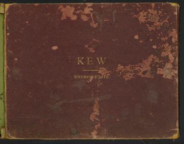 Kew Historical Society Inc
Book, Henry de Castres Kellett BT, Kew Where We Live : Kew Illustrated, 1891
At the beginning of the 1890s, the Kew businessman and Town Councillor, Henry Kellett, commissioned J.F.C. Farquhar to photograph scenes of Kew. These scenes included panoramas as well as pastoral scenes. The resulting set of twelve photographs was assembled in an album, Kew Where We Live, from which customers could select images for purchase.The preamble to the album describes that the photographs used the ‘argentic bromide’ process, now more commonly known as the gelatine silver process. This form of dry plate photography allowed for the negatives to be kept for weeks before processing, hence its value in landscape photography. The resulting images were considered to be finely grained and everlasting. Evidence of the success of Henry Kellett’s venture can be seen today, in that some of the photographs are held in national collections.It is believed that the Kew Historical Society’s copy of the Kellett album is unique and that the photographs in the book were the first copies taken from the original plates. It is the first and most important series of images produced about Kew. The individual images have proved essential in identifying buildings and places of heritage value in the district.A unique Illustrated book, comprising a series of twelve plates of panoramic and landscape photographs of Kew, commissioned from the Melbourne (and Kew) photographer JFC Farquhar, by the Kew stationer Henry Kellett. The book was published in 1891, so it is presumed that the photographs provided by Farquhar were taken in 1891 or in the previous year. Photographs from the cloth bound book were offered by Kellett for sale separately; hence a number are in public collections. The book is in very poor condition, the leaves having separated from the spine. The cover is suffering from red rot while the mounts of each book plate are dirty and frequently suffering from foxing. The actual silver albumen plates variably suffer from foxing and iridescence caused by the deterioration resulting from the photographic process. Each part of the book can be viewed in this record in sequential format.KEW WHERE WE LIVE / KEW ILLUSTRATED / THE ACCOMPANYING ILLUSTRATIONS ARE PHOTOGRAPHIC VIEWS OF KEW AND ITS SURROUNDINGS, EXECUTED BY THE "ARGENTIC BROMIDE PROCESS", WHICH ENSURES ABSOLUTE PERMANENCY OF THE PHOTOGRAPH. IN A FEW YEARS HENCE WHEN MOST OF THE OLD LANDMARKS WILL HAVE DISAPPEARED THESE VIEWS WILL BE A VALUABLE MEMENTO OF KEW AS IT WAS IN 1891. ANY OF THESE ILLUSTRATIONS GAN BE OBTAINED FROM MR. H. KELLETT, HIGH STREET, KEW, IN SINGLE COPIES, IN THE SAME SIZE AS THOSE HEREIN AT 2s PER COPY. THEY MAY ALSO BE OBTAINED IN THE FOLLOWING SIZES FOR FRAMING:- / ACTUAL SIZE OF PHOTOGRAPH 15 INCHES X 12 INCHES @ 8. 6d EACH / 22 INCHES X 16 INCHES @ 15s EACH / PRIVATE RESIDENCES AND ESTATES / SPECIAL ARRANGEMENTS CAN BE MADE FOR TAKING VIEWS OF PRIVATE RESIDENCES - INTERIOR AND EXTERIOR - AND FOR GROUPS, &C., IN ANY SIZE UP TO 40 INCHES BY 30 INCHES BY THE "ARGENTIC BROMIDE" PROCESS UPON APPLICATION TO / MR H. KELLETT / HIGH STREET, KEW.kew illustrated, kew where we live, photographic books, henry kellett, jfc farquhar - photographer -
 Kiewa Valley Historical Society
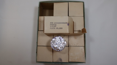
Ink Rolls - Labelling Cartridges for Addressograph Machine
The ink rolls were used in an addressograph machine. The addressograph machine used plates that contained names, addresses and classifications of each State Electricity Commission of Victoria employee working on the Kiewa Hydro Electric Scheme. The plates were put through the machine stamped in ink onto pay envelopes. See also: KVHS 0848, KVHS 1233The State Electricity Commission of Victoria employed many people on the Kiewa Hydro Electric Scheme and used the latest technology of the time to pay each of them including providing each one with a pay slip.2 large cardboard boxes, with lids, containing 3 by 4 rows of small white cardboard boxes. Inside the small boxes is a roll of ink covered by aluminium foil. Ref. KVHS 0848 which is the Addressograph MachineOn the end of one of the large boxes "For Addressograph / Purple / 1-1 and a quarter inches" / Class 22,000" Also a white label stuck on with '583' On each of the small boxes - For Addressograph / Purple / 1-1 and a quarter inches / Class 22,000 On the end of one of the lids handwritten in ink. "SF 125.7.0"addressograph machine; payroll; state electric commission of victoria; kiewa hydro electric scheme; office work;