Showing 756 items
matching line drawings
-
 Moorabbin Air Museum
Document (Item) - Vickers Viscount 700 Series story with line drawing (Photocopies)
... Vickers Viscount 700 Series story with line drawing... with line drawing (Photocopies) ... -
Moorabbin Air Museum
Document (Item) - De Havilland Canada Caribou story with line drawing (Photocopies)
... De Havilland Canada Caribou story with line drawing... with line drawing (Photocopies) ... -
Moorabbin Air Museum
Document (Item) - McDonnell Masterpiece story The Five Grand Fighter F4 Phantom with line drawing (Photocopies)
... Phantom with line drawing (Photocopies)... Grand Fighter F4 Phantom with line drawing (Photocopies) ... -
Moorabbin Air Museum
Document (Item) - Chinook helicopter CH47 stories with line drawing (Photocopies)
... Chinook helicopter CH47 stories with line drawing... with line drawing (Photocopies) ... -
 Ballarat Tramway Museum
Map - Map/s, State Electricity Commission of Victoria (SECV), Ballarat bus routes, 1971
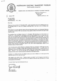
Set of five maps prepared by the SEC/Transport Regulation Board? reviewing the option for Ballarat bus routes after the closure of the Ballarat tramway system. Based on SEC drawing No. BA-D1-2222, drawn at 1" = 20 chains. Shows streets in Ballarat and Sebastopol areas. 1775.1 - tram lines shown in heavy blue lines, with grey and yellow (actual operating bus routes at the time?) routes marked out. A red dashed line defines the general built up area. 1775.2 - "PLAN A" - shows various routes in different colours for Davis, Sproule, Hick ex Whkes, Lyons, Braybrooks and Witkins services and existing tram lines. 1775.3 - "Plan B" 1775.4 - "Plan C" 1775.5 - "Plan D" 1175.6 - Plan as above, but showing existing bus routes, tram routes and suggested tram routes. Has a small sheet of paper that was clipped to the drawing. Not dated. Not known exactly the basis that these plans were drawn up on. Drawings to be scanned.trams, tramways, closure, bus routes, tram replacement, sec, transport regulation board, ballarat, tram routes -
 Ballarat Tramway Museum
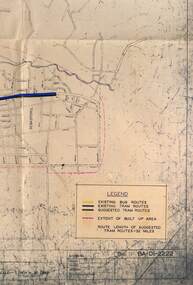
Document - Photocopy, Alan Bradley, Adelaide horse trams sold to Ballarat, 1995
Photocopy of a letter from John Radcliffe past President of the Australian Electric Transport Museum, Adelaide written on 5 January 1995 concerning the two Adelaide horse trams sold to Ballarat for use on the Sebastopol line following the Sebastopol fire in Oct. 1909. Notes the types of cars that could have been sold and other sources of information. Attached to the photocopy, not from John Radcliffe but from Alan's files are 14 drawings/sketches of Adelaide horse trams - side and end elevations, prepared by LSK.trams, tramways, horse trams, adelaide, sebastopol, depot fire -
Moorabbin Air Museum
Drawing (Item) - Line drawing Boeing B52H
... Line drawing Boeing B52H...Line drawing Boeing B52H... Moorabbin melbourne Line drawing Boeing B52H Drawing Line drawing ... -
 Ballarat Tramway Museum
Document - Report, Office of the Chief Investigator, "Fire on Tram W class Tram 946 La Trobe Street 15 January 2009", 9/11/2009 12:00:00 AM
Thirty one page, colour printed (laser) report titled "Fire on Tram W class Tram 946 La Trobe Street 15 January 2009" describing the investigation by the Victorian Office of the Chief Investigator, Transport and Marine Safety Investigations - Report No. 2009/03. Details the event of the incident, failed motor insulation and failed line breakers, provides details of the tram, electrical drawings, failed components with photographs.trams, tramways, w class, accidents, fire -
 Ballarat Tramway Museum
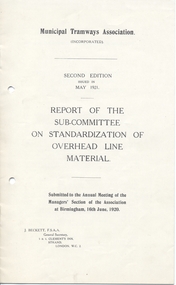
Document - Report, Municipal Tramways Association, "Report of the Sub-Committee on Standardization of Overhead Line Material", Jun. 2020
Yields information about the materials used in tramway overhead and could have been used as a specification by ESCo Engineers and standardization of materials in order to reduce costs.Sixteen page booklet, titled "Report of the Sub-Committee on Standardization of Overhead Line Material", published by Municipal Tramways Association, 2nd Edition, issued in May 1921, Submitted to the Annual Meeting of the Manager's Section of the Association at Birmingham, 16/6/1920 under the signature of J. Beckett, General Secretary. Gives an Appendix - List of Drawings, Suggested specification for Standard Copper Trolley Wire, steel span and guard wires, and Overhead wire fittings trams, tramways, overhead, trolley wire -
 Bendigo Historical Society Inc.
Book - MERLE HALL COLLECTION: THE ALBUM OF SANDHURST VIEWS
A bound book of 16 drawings B&W (lithographs?) in ''photographic'' detail of well-known Sandhurst Views - Town Hall, Mechanics Institute, Masonic Hall, Bendigo Hospital, Bendigo Benevolent Asylum, Post and Telegraph Offices, Mining Exchange, View from Post Office Tower looking East, View from Post Office Tower looking West, Central State School, Alexandra Fountain, Upper Lake,Rosalind Park, Fernery Rosalind Park, St Pauls Church, Bishop's Palace, General View - New Chum Line, Koch's ''Pioneer'' Crushing Works, Quartz Crushing batteries, Town Hall - Eaglehawk, Railway Station. Appended with two pages summarizing Sandhurst history; current councillors and officers, brief review of five places - Bendigo Hospital, Benevolent Asylum, Mechanics Institute and Free Library, School of Mines and Industries, Masonic Hall. Date is given as ''The present (1888) occupants are ....'' -
 Bendigo Historical Society Inc.
Slide - DIGGERS & MINING: THE DIGGINGS - THE DIGGERS
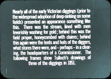
Diggers & Mining: The Diggings - The Diggers. Slide reads: Nearly all of the early Victorians diggings (prior) to the widespread adoption of deep skinking on some fields) presented an appearance something like this. There was the stream, lined with men feverishly washing for gold; behind this was the field proper, honeycombed with claims; behind this again were the tents and huts of the diggers, what stores there were, and - perhaps - in a clearing, the headquarters of a Commissioner. The following frames show Tulloch's drawings of three of the diggings in 1851. Markings: 2 994.LIF 6. Used as a teaching aid.hanimounteducation, tertiary, mining -
 Queenscliffe Maritime Museum
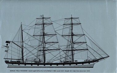
Drawing (item) - POLLY WOODSIDE drawing above the water line, Drawing of the POLLY WOODSIDE above the water line
... POLLY WOODSIDE drawing above the water line.... the water line Drawing POLLY WOODSIDE drawing above the water line. ...POLLY WOODSIDEsquare rigged sailing ship drawing -
 Ballarat Tramway Museum
Drawing, Victorian Railways, Ears for Tramway Overhead Construction, 1924
Gives the design details of the device or fitting known as a trolley wire ears that holds a tramway copper trolley wire in position. Notes that the drawing was traced in 1924 from a MMTB drawing. Has details for a splicing ear, straight line ear. feeder ear and curve ear along with details for nuts and screws.Yields information about the design of four different types of trolley wire fittings and how they were fabricated for use on the two tram lines, or electric street railways operated by the Victorian Railways.Dyeline print of Victorian Railways drawing number 4057 - Ears for Tramway Overhead ConstructionHas number "7513 D.33" in black pen in bottom right hand corner.tramways, trams, overhead, victorian railways, trolley wire, engineering, electrical engineering -
 Ballarat Tramway Museum
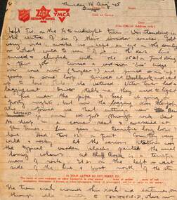
Letter - from Wal Larsen to Wal Jack re the Tenterfield railway, Wal Larsen, Aug 1945
Wal Jack had an extensive range of correspondents throughout Australia and the world who often prepared extensive notes and records for him. This letter from Wal Larsen of Bright, dated 16 Aug 1945 describes a trip to Tenterfield, notes on crews, their hats, station layouts and detailed map. With the letter is a plan of the station layouts of the West Tamworth to Barraba line dated 6-10-45. Demonstrates some of the correspondence that Wal Jack received from around the world and that of Wal Larsen.Letter - handwritten with ink on a set of four ruled Salvation Army - Australian Comfort Fund and YMCA printed sheets and a drawing on a foolscap sheet on the rear of Australian Military Forces for - "Return on Members of the Permanent forces entitled to Medical Attendance"letters, wal jack, railways, nsw, wal larsen, tenterfield, barraba, west tamworth, nswgr -
 Ballarat Tramway Museum
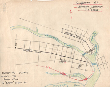
Drawing - Gisborne NZ - Battery Tramway - plan, Wal Jack, c1946
Wal Jack had an extensive range of correspondents throughout Australia and the world who often provided him with detailed drawings and notes on various tramway systems. This drawing shows the small battery-powered (four) tramcar system in Gisborne NZ. Shows the NZ rail line, rivers and the length of each route, and the dates of operation. Based on the handwriting, prepared by Wal Jack himself. Yields information about Wal Jack's extensive recording and research work.Drawing - black, red and blue ink or colour pencil on quarto size paper of the Gisborne NZ tramway system.tramways, wal jack, drawings, maps, tramcars, gisborne nz -
 Ballarat Tramway Museum
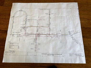
Drawing - VB4/7184C, State Electricity Commission of Victoria - Ballarat office, "Diagrammatic Arrangement of Feeders and Trolley Wire", 2-9-1958
Print of drawing number VB4/7184C "Diagrammatic Arrangement of Feeders and Trolley Wire", marked up in colour showing the various feeder and trolley wire arrangements for the central part of Ballarat and the Gardens line. Shows the detailed switch locations that enable the overhead to be isolated or changed when electrical work was being undertaken on the overhead that required it to be isolated. Shows how the various sections were fed from the power station. Revision C issued 2-9-1958.Yields information about the arrangement of the power supply to the trams from the power station and changes made to the system about 13 years prior to closure. Dyeline print on white paper of Drawing - "Diagrammatic Arrangement of Feeders and Trolley Wire" - VB4/7184Ctramways, ballarat, secv, trolley wire, feeder cables, overhead, power station, electrical engineering, electrical switching -
 Ballarat Tramway Museum
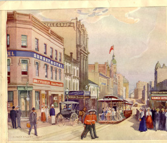
Drawing - Illustration/s, Albert Collins - Original artwork, King St. Sydney Cable trams
Colour print of a water colour by Albert Collins (1945) of a King St. Sydney with a Sydney cable tram set, titled "Another link with the past - King St. in the nineties", mounted onto textured card, lined on outer edges, with a piece of paper detailing the work attached to rear and an inscription.On rear "Compliments from Roy Field"trams, tramways, sydney, cable trams, king st -
Kew Historical Society Inc
Journal, Kewriosity : July 1985
... of potential heritage asset [survey form] / p9.Further comment [Line ...Kew Safeway expansion / p1. Community Notes [Clubs and Societies; General; Politics; Religious notices; Support Groups] / p2&16.Update: Notes from Council - Kew's parklands / Cr Robin Saunders, Mayor [of Kew] p3. In Brief [We are desperate - Kew Community Bus; No Vacancy - Davis Street Kindergarten; Kew contributes to Housing Council; This is an emergency - Meals on Wheels; Elections coming up; Assistance grants distributed; Fence trees soon] / p4. Traffic Management / p4. Concern for residents top priority in hotels dispute [Prospect Hill Hotel; Harp of Erin/ p5. Friends of Kew Library take action {Library relocation; Kew Historical Society; Toy Library] / p5. Baby safety bassinet loan scheme off and running / p5. Neighbourhood Watch - Keeping an eye open [Operation identification / Neighbourhood Watch works; Home security meeting] / p6. Kew Community House - What we are about / p6. Kew Heritage Survey - Information exchange meeting / p7. Heritage assets [Houses and other buildings; Other structures and works; Streetscapes; Sites; Natural areas and open space; Panoramas, vistas or views] / p8. Nomination of potential heritage asset [survey form] / p9.Further comment [Line drawing - 'Ivy Grange'] / p10. Youth Page - Youth Theatre a-goer; Apology / p11. Some ways to avoid burning [incinerators] / p12. Learn how to paint on silk / p12. The ABC of the CAB [Citizens Advice Bureau] / p13. High times at Kew's Cemetery / Ellen Coates [social history] p14. Archer of the year 1984/85 [Gerry Hevey, Kew City Bowmen] / p15. Library News / p15. This Kewriosity is being delivered to you by - Kew Women's Hockey Club / p15. Letters - Small Business too pricey /Mrs J Chambers; Theft and vandalism hits Bowmen / Jim Bagnelli; A case of discrimination / Kathy Don.Kewriosity was a local newsletter combining Kew Council and community news. It was published between November 1983 and June 1994, replacing an earlier Kewriosity [broad] Sheet (1979-84). In producing Kewriosity, Council aimed to provide a range of interesting and informative articles covering its deliberations and decision making, together with items of general interest and importance to the Kew community and information not generally available through daily media outlets.non-fictionKew Safeway expansion / p1. Community Notes [Clubs and Societies; General; Politics; Religious notices; Support Groups] / p2&16.Update: Notes from Council - Kew's parklands / Cr Robin Saunders, Mayor [of Kew] p3. In Brief [We are desperate - Kew Community Bus; No Vacancy - Davis Street Kindergarten; Kew contributes to Housing Council; This is an emergency - Meals on Wheels; Elections coming up; Assistance grants distributed; Fence trees soon] / p4. Traffic Management / p4. Concern for residents top priority in hotels dispute [Prospect Hill Hotel; Harp of Erin/ p5. Friends of Kew Library take action {Library relocation; Kew Historical Society; Toy Library] / p5. Baby safety bassinet loan scheme off and running / p5. Neighbourhood Watch - Keeping an eye open [Operation identification / Neighbourhood Watch works; Home security meeting] / p6. Kew Community House - What we are about / p6. Kew Heritage Survey - Information exchange meeting / p7. Heritage assets [Houses and other buildings; Other structures and works; Streetscapes; Sites; Natural areas and open space; Panoramas, vistas or views] / p8. Nomination of potential heritage asset [survey form] / p9.Further comment [Line drawing - 'Ivy Grange'] / p10. Youth Page - Youth Theatre a-goer; Apology / p11. Some ways to avoid burning [incinerators] / p12. Learn how to paint on silk / p12. The ABC of the CAB [Citizens Advice Bureau] / p13. High times at Kew's Cemetery / Ellen Coates [social history] p14. Archer of the year 1984/85 [Gerry Hevey, Kew City Bowmen] / p15. Library News / p15. This Kewriosity is being delivered to you by - Kew Women's Hockey Club / p15. Letters - Small Business too pricey /Mrs J Chambers; Theft and vandalism hits Bowmen / Jim Bagnelli; A case of discrimination / Kathy Don. publications -- city of kew (vic.), kewriosity, council newsletters, community newsletters -
 Kew Historical Society Inc
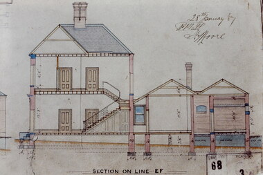
Slide - Architectural Drawing, Kew Public Offices, 1887
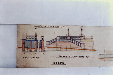
A civic campaign for new public offices developed in Kew in the 1880s. After much deliberation, the location chosen was the junction of Bulleen and Cotham Roads. The buildings were designed by George Watson and John Henry Harvey, architects within the Department of Public Works (Victoria). Building was commenced in 1887, and after one year, the buildings were opened. The Post Office was transferred to the new Commonwealth Government in 1901. The Police Station and Court House, sold by the Victorian Government to the City of Boroondara in 2007, are now a community cultural centre and performing arts venue.The buildings were listed on the Victorian Heritage Register Register (HO885) in 1991. They are historically and architecturally significant to the State Of Victoria because Watson and Harvey's designs exhibit diversity in integrating civil offices, they accommodate the apex of road junctions, and they demonstrate a departure from the contemporaneously favoured High Victorian Classical to the Queen Anne style in the design of civic buildings. 35mm colour transparency of an original plan by George Watson and John Henry Harvey, architects of the Department of Public Works (Victoria), in 1887 for New Public Offices at Kew. This plan was copied by the donor from an original held at the Commonwealth Archives in Brighton (Vic). The copy was made to illustrate a report that the donor made on ‘The functional planning design, building materials and construction methods of the Kew Post Office’ as part of course work at RMIT.SECTION ON LINE E-Fkew court house, kew police station, kew post office, architectural drawings, khs - slides, new public offices — kew (vic.), architecture — queen anne style -
 Kew Historical Society Inc
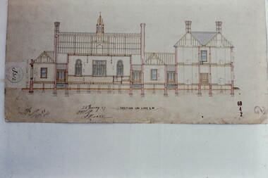
Slide - Architectural Drawing, Kew Public Offices, 1887
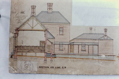
A civic campaign for new public offices developed in Kew in the 1880s. After much deliberation, the location chosen was the junction of Bulleen and Cotham Roads. The buildings were designed by George Watson and John Henry Harvey, architects within the Department of Public Works (Victoria). Building was commenced in 1887, and after one year, the buildings were opened. The Post Office was transferred to the new Commonwealth Government in 1901. The Police Station and Court House, sold by the Victorian Government to the City of Boroondara in 2007, are now a community cultural centre and performing arts venue.The buildings were listed on the Victorian Heritage Register Register (HO885) in 1991. They are historically and architecturally significant to the State Of Victoria because Watson and Harvey's designs exhibit diversity in integrating civil offices, they accommodate the apex of road junctions, and they demonstrate a departure from the contemporaneously favoured High Victorian Classical to the Queen Anne style in the design of civic buildings. 35mm colour transparency of an original plan by George Watson and John Henry Harvey, architects of the Department of Public Works (Victoria), in 1887 for New Public Offices at Kew. This plan was copied by the donor from an original held at the Commonwealth Archives in Brighton (Vic). The copy was made to illustrate a report that the donor made on ‘The functional planning design, building materials and construction methods of the Kew Post Office’ as part of course work at RMIT.SECTION ON LINE C-Hkew court house, kew police station, kew post office, architectural drawings, khs - slides, new public offices — kew (vic.), architecture — queen anne style -
 Kew Historical Society Inc
Slide - Architectural Drawing, Kew Public Offices, 1887
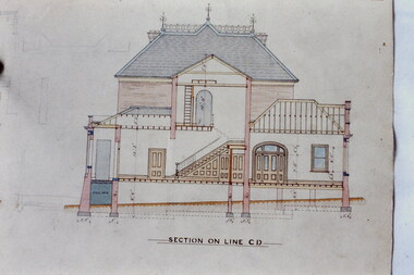
A civic campaign for new public offices developed in Kew in the 1880s. After much deliberation, the location chosen was the junction of Bulleen and Cotham Roads. The buildings were designed by George Watson and John Henry Harvey, architects within the Department of Public Works (Victoria). Building was commenced in 1887, and after one year, the buildings were opened. The Post Office was transferred to the new Commonwealth Government in 1901. The Police Station and Court House, sold by the Victorian Government to the City of Boroondara in 2007, are now a community cultural centre and performing arts venue.The buildings were listed on the Victorian Heritage Register Register (HO885) in 1991. They are historically and architecturally significant to the State Of Victoria because Watson and Harvey's designs exhibit diversity in integrating civil offices, they accommodate the apex of road junctions, and they demonstrate a departure from the contemporaneously favoured High Victorian Classical to the Queen Anne style in the design of civic buildings. 35mm colour transparency of an original plan by George Watson and John Henry Harvey, architects of the Department of Public Works (Victoria), in 1887 for New Public Offices at Kew. This plan was copied by the donor from an original held at the Commonwealth Archives in Brighton (Vic). The copy was made to illustrate a report that the donor made on ‘The functional planning design, building materials and construction methods of the Kew Post Office’ as part of course work at RMIT.SECTION ON LINE C-Dkew court house, kew police station, kew post office, architectural drawings, khs - slides, new public offices — kew (vic.), architecture — queen anne style -
 Kew Historical Society Inc
Slide - Architectural Drawing, Kew Public Offices, 1887
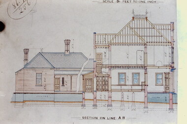
A civic campaign for new public offices developed in Kew in the 1880s. After much deliberation, the location chosen was the junction of Bulleen and Cotham Roads. The buildings were designed by George Watson and John Henry Harvey, architects within the Department of Public Works (Victoria). Building was commenced in 1887, and after one year, the buildings were opened. The Post Office was transferred to the new Commonwealth Government in 1901. The Police Station and Court House, sold by the Victorian Government to the City of Boroondara in 2007, are now a community cultural centre and performing arts venue.The buildings were listed on the Victorian Heritage Register Register (HO885) in 1991. They are historically and architecturally significant to the State Of Victoria because Watson and Harvey's designs exhibit diversity in integrating civil offices, they accommodate the apex of road junctions, and they demonstrate a departure from the contemporaneously favoured High Victorian Classical to the Queen Anne style in the design of civic buildings. 35mm colour transparency of an original plan by George Watson and John Henry Harvey, architects of the Department of Public Works (Victoria), in 1887 for New Public Offices at Kew. This plan was copied by the donor from an original held at the Commonwealth Archives in Brighton (Vic). The copy was made to illustrate a report that the donor made on ‘The functional planning design, building materials and construction methods of the Kew Post Office’ as part of course work at RMIT.SECTION ON LINE A-B / SCALE 8 FEET TO ONE INCHkew court house, kew police station, kew post office, architectural drawings, khs - slides, new public offices — kew (vic.), architecture — queen anne style -
 Kew Historical Society Inc
Slide - Architectural Drawing, Kew Public Offices, 1887
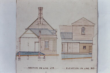
A civic campaign for new public offices developed in Kew in the 1880s. After much deliberation, the location chosen was the junction of Bulleen and Cotham Roads. The buildings were designed by George Watson and John Henry Harvey, architects within the Department of Public Works (Victoria). Building was commenced in 1887, and after one year, the buildings were opened. The Post Office was transferred to the new Commonwealth Government in 1901. The Police Station and Court House, sold by the Victorian Government to the City of Boroondara in 2007, are now a community cultural centre and performing arts venue.The buildings were listed on the Victorian Heritage Register Register (HO885) in 1991. They are historically and architecturally significant to the State Of Victoria because Watson and Harvey's designs exhibit diversity in integrating civil offices, they accommodate the apex of road junctions, and they demonstrate a departure from the contemporaneously favoured High Victorian Classical to the Queen Anne style in the design of civic buildings. 35mm colour transparency of an original plan by George Watson and John Henry Harvey, architects of the Department of Public Works (Victoria), in 1887 for New Public Offices at Kew. This plan was copied by the donor from an original held at the Commonwealth Archives in Brighton (Vic). The copy was made to illustrate a report that the donor made on ‘The functional planning design, building materials and construction methods of the Kew Post Office’ as part of course work at RMIT.SECTION ON LINE J-K / ELEVATION LIN... …kew court house, kew police station, kew post office, architectural drawings, khs - slides, new public offices — kew (vic.), architecture — queen anne style -
 Kew Historical Society Inc
Slide - Architectural Drawing, Kew Public Offices, 1887
A civic campaign for new public offices developed in Kew in the 1880s. After much deliberation, the location chosen was the junction of Bulleen and Cotham Roads. The buildings were designed by George Watson and John Henry Harvey, architects within the Department of Public Works (Victoria). Building was commenced in 1887, and after one year, the buildings were opened. The Post Office was transferred to the new Commonwealth Government in 1901. The Police Station and Court House, sold by the Victorian Government to the City of Boroondara in 2007, are now a community cultural centre and performing arts venue.The buildings were listed on the Victorian Heritage Register Register (HO885) in 1991. They are historically and architecturally significant to the State Of Victoria because Watson and Harvey's designs exhibit diversity in integrating civil offices, they accommodate the apex of road junctions, and they demonstrate a departure from the contemporaneously favoured High Victorian Classical to the Queen Anne style in the design of civic buildings. 35mm colour transparency of an original plan by George Watson and John Henry Harvey, architects of the Department of Public Works (Victoria), in 1887 for New Public Offices at Kew. This plan was copied by the donor from an original held at the Commonwealth Archives in Brighton (Vic). The copy was made to illustrate a report that the donor made on ‘The functional planning design, building materials and construction methods of the Kew Post Office’ as part of course work at RMIT.SECTION ON LINE L-Mkew court house, kew police station, kew post office, architectural drawings, khs - slides, new public offices -- kew (vic.), architecture — queen anne style -
 Williamstown Botanic Gardens- Hobsons Bay City Council
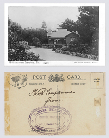
Postcard – Williamstown Botanic Gardens, The Crown Studios, Sydney, c1900-1920
The Curator’s lodge, designed by the Town Surveyor, HV Champion, was constructed in 1907 following the re-organisation of the north-east corner with the demolition of the old curator's cottage and erection of new gates. Lee Heap Furniture Warehouse of Williamstown used the postcards to advertise. The postcards are evidence of the interest the gardens held as a subject for postcard publishers. The text and images provide a snapshot into fashions, social interests and concerns of the time. The professionally produced images provide a pictorial history of Gardens including changing planting styles, various structures and features of the Gardens eg the aviary, cannons, the fountain, the second Curator’s Lodge and gates. The images offer an opportunity to compare garden vistas with the present day.A sepia image looking across a path bordered with rocks of a house (the Curators lodge) behind a fence. In front of the fence there is a young girl sitting on a rock with a young boy standing beside her. The house is timber with two brick chimneys, the right hand one half hidden by foliage. The house is federation style with timber battening above the front window. A timber frieze is above a verandah supported by three posts and light coloured brackets. Front: ‘Williamstown Gardens. Vic.’ ‘0457/1’ THE CROWN STUDIOS, SYDNEY’. Reverse: Centre top ‘POST CARD’ with a logo in the middle of the words. Left top corner a drawing of an artist’s board and brushes with a camera in the centre. Left side ‘MESSAGE ONLY.’ Right side ‘ADDRESS ONLY.’ Top right corner inside a dotted rectangle ‘STAMP HERE’. Bottom on card ‘BY THE CROWN STUDIOS, SYNDEY.’ Under the vertical line down the middle line ‘Neither the Address not the Message must cross this line’. In ink ‘With Compliments / from’. An oval stamp with scalloped rim ‘LEE HEAP FURNITURE MANUFACTURER’ inside inner oval ‘FURNITURE WAREHOUSE, / WILLIAMSTOWN’.postcard, gardens, post-card, williamstown-botanic-gardens, hobsons-bay-city-council, curator’s lodge, children, federation style, crown studios, lee heap furniture warehouse -
 Williamstown Botanic Gardens- Hobsons Bay City Council
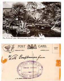
Postcard – Williamstown Botanic Gardens, The Crown Studios, Sydney, c1900-1920
The lake was built in 1904, during the curatorship of Mr Thake. Lee Heap Furniture Warehouse of Williamstown used the postcards to advertise. The postcards are evidence of the interest the gardens held as a subject for postcard publishers. The text and images provide a snapshot into fashions, social interests and concerns of the time. The professionally produced images provide a pictorial history of Gardens including changing planting styles, various structures and features of the Gardens eg the aviary, cannons, the fountain, the second Curator’s Lodge and gates. The images offer an opportunity to compare garden vistas with the present day.Sepia image of the ornamental lake and part of the Curator’s Lodge in the background on the left side of card. The small island with a succulent is in the centre of the image with a similar plant on the right side of it. The water is edged with rocks. Reflections of the plantings and lodge can be seen.Front: ‘The Artificial Lake, Williamstown Gardens. Vic.’ ‘0457/3’ ‘THE CROWN STUDIOS, SYDNEY’. Reverse: Centre top ‘POST CARD’ with a logo in the middle of the words. Left top corner a drawing of an artist’s board and brushes with a camera in the centre. Left side ‘MESSAGE ONLY.’ Right side ‘ADDRESS ONLY.’ Top right corner inside a dotted rectangle ‘STAMP HERE’. Bottom on card ‘BY THE CROWN STUDIOS, SYNDEY.’ Under the vertical line down the middle line ‘Neither the Address not the Message must cross this line’. In ink ‘With Compliments from’. An oval stamp with scalloped rim ‘LEE HEAP FURNITURE MANUFACTURER’ inside inner oval ‘FURNITURE WAREHOUSE, / WILLIAMSTOWN’.postcard, gardens, post-card, williamstown-botanic-gardens, hobsons-bay-city-council, ornamental lake, crown studios, lee heap furniture warehouse -
Maldon Vintage Machinery Museum Inc
French Curves
.1) Wooden box with hinged lid. 22 wooden and 3 plastic flat curved patterns loose in the box. Several are numbered. .2) 3 clear plastic curves in a pouch. Made in Italy. .3) 3 clear plastic curves in a pouch. Made in Italy. .3 .....31) Plastic curves. French curves are used in a drawing office to draw a smooth best fit line through a number of points..25) "42 / Engineering / TB5" etched into plastic. .2 & .2) Pouches marked "LONGO Made in Italy" in gold.trades, drafting -
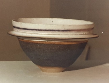
 Federation University Art Collection
Ceramic, Robin Welch, Stoneware Bowl by Robin Welch, c1980
Robin WELCH ( 23 July 1936-5 December 2019) Born Nuneaton, Warwickshire, England Robin Welch is one of the most highly respected contemporary British potters. The full range of his work includes large vessels with related paintings, fine drawings, and distinctive bowls and vases which explore colour, surface texture, form, detail of edge, and line. He is one of small group of significant British potters who expanded the language of throwing pots on the wheel through post-wheel additions and alteration. This gave his generally cylindrical forms a more organic and sculptural aspect, but their heavily coloured and textured surfaces were as much about painting, too, as Robin sought an integration of the visual disciplines he enjoyed. As he once wrote: “There’s no divide between art or craft. You decide to be an artist and you’ll use anything. If marooned on a desert island you’d use driftwood.” (https://www.theguardian.com/artanddesign/2019/dec/27/robin-welch-obituary, accessed 23 March 2021) Initially studying at Penzance School of Art under Michael Leach (son of Bernard Leach) and the Central School of Art, London Robin Welch then worked part-time at the Leach Pottery between 1953 and 1959 before opening his own pottery in London's west end (1960 to 1962). After a couple of years of world travel, including working in Australia from 1962 to1965 helping Ian Sprague set up his Mungeribar Pottery and exhibiting in Melbourne, Robin Welch returned to England setting up Stadbroke Pottery in Eye, Suffolk in 1965. Apart from his studion work Robnin Welch was a skilled designer for industry including Wedgwood. When not in his Suffolk studio Robin Welch spent much time in Australia where he appreciated the outback’s arid earth, brilliant light, grittier textures and luminous colour. When not in his Suffolk studio Robin Welch spent much time in Australia where he appreciated the outback’s arid earth and brilliant light, its grittier textures and luminous colour, qualities he sought to convey in-the-round and on canvas. Apart from his studion work Robnin Welch was a skilled designer for industry including Wedgwood, Midwinter and Denby.Stoneware bowl with flange. Glazed in white matt crackle with a faint copper red tint. Dry black glazed rim. Gift of the artist.Robin Welch stamped on baseceramics, robin welch, gippsland, gppsland campus, jan feder memorial ceramics collection -
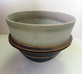
 Federation University Art Collection
Ceramic - Artwork - Ceramics, Stoneware Bowl by Robin Welch, c1980, 1980
Robin WELCH (1936- ) Born Nuneaton, Warwickshire, England Robin Welch is one of the most highly respected contemporary British potters. The full range of his work includes large vessels with related paintings, fine drawings, and distinctive bowls and vases which explore colour, surface texture, form, detail of edge, and line. Initially studying at Penzance School of Art and the Central School of Art, London Robin Welch then worked part-time at the Leach Pottery between 1953 and 1959 before opening his own pottery in London's west end (1960 to 1962). After a couple of years of world travel, including working in Australia from 1962 to1965 helping Ian Sprague set up his Mungeribar Pottery and exhibiting in Melbourne, Robin Welch returned to England setting up Stadbroke Pottery in Eye, Suffolk in 1965. This work is part of the Jan Feder Memorial Ceramics Collection. Jan Feder was an alumna of the Gippsland Campus who studied ceramics on the campus. She passed away in the mid 1980s. Her student peers raised funds to buy ceramic works in her memory. They bought works from visiting lecturers who became leading ceramic artists around the world, as well as from many of the staff who taught there.Stoneware bowl with single flange. White glaze with copper tint. Dry black glaze underneath and airbrushed lustre banding. Robin Welch stamped on base.ceramics, robin welch, jan feder memorial ceramics collection, jan feder, gippsland campus, stadbroke pottery, mungeribar pottery