Showing 3153 items matching "miles"
-
 Bendigo Historical Society Inc.
Document - ANCIENT ORDER OF FORESTERS NO. 3770 COLLECTION: CORRESPONDENCE
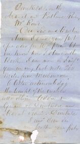
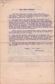
Letter to Mr. Rowe mentioning he sent a PO Order for 10/- and to let him know how he stood on the book. He also mentions that in his last note he was 200 miles from Melbourne. He would like a letter acknowledging receipt. He also says to address him as Guard of Dunkuld and Ararat ?, Dunkuld. Signature missing.societies, aof, correspondence, ancient order of foresters no. 3770 collection - correspondence, mr rowe, dunkuld and ararat ? -
 Bendigo Historical Society Inc.
Photograph - W. D. MASON COLLECTION: BENDIGO TOWN HALL, 1920-1930
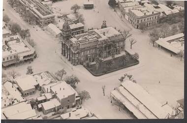
Aerial photograph, Bendigo Town Hall, in centre of picture. Sign on top of Town Hall 'Bendigo Drome 7 miles' Also in photo, Sandhurst Hotel; Public Offices under-construction; the Metropolitan Hotel; the Market, another hotel .The photo was taken by Sir Raymond Garrett around the late 1920s early 1930s. His daughter, Ann Kelly, donated the photo.Sir Raymond Garrettphotograph, aerial, bendigo -
 Ballarat Tramway Museum
Negative, Travis Jeffrey, 5/08/1962 12:00:00 AM
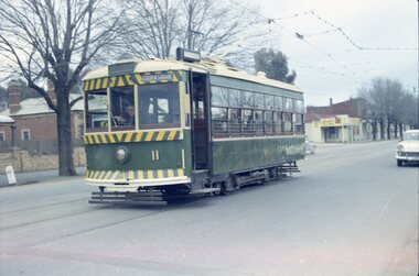
Colour Negative No. N403, of Bendigo Birney No. 11, outbound to Golden Square at Honeysuckle St. Loop?, has a mile post oppose the front of the tram. Tram has the destination of Golden Square. Photo possibly 17/6/1962. Colour laser printed copy of image stored in box 73. Original negative hires scan and image updated 28/5/2020.In red pen on folder that contained negative, "NR91B" and "5 Aug 62". trams, tramways, bendigo, golden square, honeysuckle st., tram 11 -
 University of Melbourne, Burnley Campus Archives
Newspaper - Newspaper Cutting, Bringing home the oats, 1944
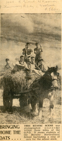
Newspaper cutting with a photo of 6 male students standing on a cart of oats being pulled by a draught horse. The caption below the photo reads: "This rustic scene was photographed yesterday within 3 miles of the GPO. It shows students of the Burnley Horticultural School harvesting oats for the school stock. All students graduated in 1944 except L. Woolcock, who graduated in 1945.Helen Dudley has written above the photo: 1944 R. Grant, N. Rooney, J. Flannery, R. Lay, L. Woolcock, B. Ebbs.leslie woolcock, helen dudley, r. grant, n. rooney, j. flannery, r. lay, b. ebbs, students working outside, horses, oats, draught horse -
 Melbourne Tram Museum
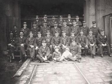
Photograph, 28 MTCo employees in a group photo at Clifton Hill cable tram depot, 16/05/1917 12:00:00 AM
Digital image of 28 MTCo employees in a group photo at Clifton Hill cable tram depot - dated 16 May 1917 - information provided by donor - see document. Depot allocation based on Edwin Mile Public Records Office records of MTCO employees - see Reg Item 2398 for employee records 2398i3 The donor thinks that Edwin is sitting first on the left.trams, tramways, mto co, cable trams, personnel, clifton hill cable tram depot, employees, conductors, gripmen, uniforms -
 Bendigo Historical Society Inc.
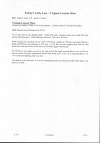
Document - PADDY'S GULLY LINE - VIRGINIA CONSOLS MINE
Handwritten page of notes on the Virginia Consols Mine on Paddy's Gully Line of Reef. Notes mention shaft being cleaned out and timbered to 100 ft. Also depth of work, timbering and geological features. Also a small piece of paper with:- Virginia Consols Mine 2 miles North of E'hawk Town Hall. Paddy's Gully Line. Notes prepared by Albert Richardson.document, gold, paddy's gully line, paddy's gully line, virginia consols mine, e'hawk town hall -
 National Wool Museum
Tin
Made in Great Britain. Collection originally owned by Strauss family of Waverley Rainbow (on road to Lake Albaculya, 12 miles from Rainbow).MERITAX ADHESIVE PLASTER (label) 1.3 mm x .91 mm -
 Charlton Golden Grains Museum Inc
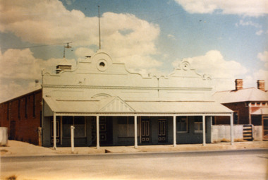
Photograph, Victoria Hall, Armstrong St Charlton c. 1960, c.1960
Victoria Hall, Armstrong St Charlton was built for E. Miles in 1884. Sid Rosewall's house is on the right. This photo taken c. 1960.Colour photograph of a single storey, triple fronted red brick building. The front of the building is painted. There are double doors for the main entrance and three single doors - one to the left and two to the right of the main doors. There is a large, ornamental parapet wall on the front of the building with a flag pole. A wide verandah runs the length of the front of the building with a pitched section over the main entrance. The LH side of the building is unpainted and has four windows high on the wall. A red brick building is partially visible on the RH side of the photo. It has two chimneys and iron roof.e. miles, s. rosewall, victoria hall, armstrong street, charlton, halls -
 Melbourne Tram Museum
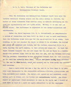
Document, Melbourne & Metropolitan Tramways Board (MMTB), "Careful Inspection, the Secret of Successful Maintenance", 1930's
Report or draft article - small sheet and 4 quarto sheets, carbon copy, titled "Careful Inspection, the Secret of Successful Maintenance", with a sub-heading "Melbourne tells how it is done." The sub-heading has been crossed out and replaced in pencil "Rolling stock maintenance in Melbourne". Has Mr. H Bell as the author. undated, during the late 1930's? Item has a number of pencil changes made to it. Item gives a background to tram maintenance statistics, the number of withdrawn trams per 1000 miles - from one every 4000 to one every 32000 miles - inspection and maintenance. Describes the maintenance and inspection procedures, day-in, drivers reports, car history sheets, visit to the workshops, responsibilities, on-road maintenance, emergency breakdown wagon, breakdown cars, overhauls, Preston workshops. Finishes off discussing costs and fleet availability.Has "Mr Russell" in pencil on the lower edge of the small sheet.trams, tramways, preston workshops, maintenance, overhauls, tramcars, mmtb -
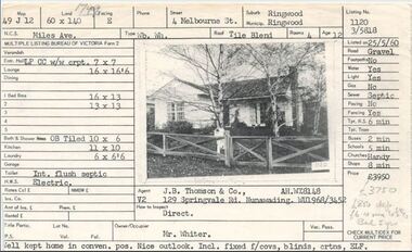 Ringwood and District Historical Society
Document, Property profile for sale of house and land, 4 Melbourne Street, Ringwood, Victoria - 1960
The house was owned by Mrs. Jessie White 4, Melbourne St. on the corner of Miles Ave. now both lost in the development of Eastland Shopping Centre.Details include map reference, dimensions of land and living space, picture of house, details of local services. Owner/Occupier Mr. Whiter. Agent J.B. Thomson & Co., 129 Springvale Road, Nunawading. -
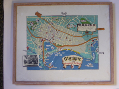 Warrnambool and District Historical Society Inc.
Advertising, Tourist Map of Warrnambool (framed x 2), 1950s
These framed tourist maps came from the Lane Foundation so it is presumed that they were from the office of Lane’s Travel Service which operated from 205 Raglan Parade Warrnambool with the known dates, the 1950s and 1960s. The proprietor, Alan Lane, was a successful Warrnambool businessman who operated a Warrnambool and district bus service as well as his travel business. He was heavily involved in local community affairs being a Warrnambool Councillor for 18 years from 1952 to 1970 and President of the Warrnambool Chamber of Commerce for six years. He was a major donor to the Warrnambool Performing Arts Centre, the Warrnambool Art Gallery and the St. John of God Hospital and left the bulk of his estate to the Alan Lane Foundation which has contributed millions of dollars to local organizations and programs. Alan Lane died in 1995. These framed maps are of some interest as examples of the tourism maps used to promote the city and district in the 1950s and 60s. This is a tourist map of the Warrnambool C.B.D. and adjoining streets produced as an advertisement for Olympic Tyres. It is multi-coloured and has cartoon sketches of the main tourist attractions and pointers to attractions outside of the main city area. It includes an inset black and white photograph of the Warrnambool Botanic Gardens and an advertisement for Olympic Tyres. It is printed on a white background and is enclosed behind glass in a wooden frame of a light brown colour. It has a wire at the back for attachment to a wall. ‘Warrnambool – 163 miles from Melbourne – a popular tourist resort offering many holiday attractions – an ideal surfing beach with all modern facilities is avalable’ ‘Fit Olympic Tyres, Champions of the Road’ alan lane foundation, warrnambool tourism -
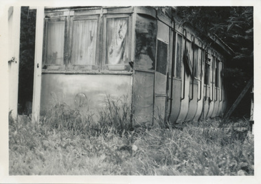 Ballarat Tramway Museum
Photograph - Digital image, Wal Jack, 23/11/1963 12:00:00 AM
Yields information how the body of a former tram was sold and use by the purchaser. Tram body later recovered by the BTM.Digital image from the Wal Jack Ballarat Album of the body after sale of ESCo 22, Sebastopol type car on a farm in Ross Creek Road, photograph on 23/11/1963. Wal Jack Photo. See image i2 for rear of photograph. See image i3 for hi res scan of print. See image i4 for hi res scan of negativeOn rear of photograph in ink "SEC Ballarat / Old No. 22 Sebastopol body in Ross Creek Road, half mile beyond Sebastopol 23/11/63" and W. Jack stamp with number "T1277"trams, tramways, sebastopol type, esco, disposal, sale of trams, tram 22 -
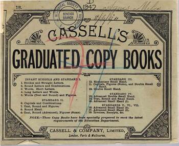 Bendigo Historical Society Inc.
Book - GRADUATED COPY BOOK (AGNES MILES), 08/06/1894
Graduated Copy Book with green cover (name of Agnes Miles handwritten in ink on front cover) Book No 18 (invoices, receipts etc) All exercises completed in ink. Printed by Cassell & Co Ltd London, Paris and Melbourne. Advertising for Cassell education products inside/outside front and rear covers. Various RHSV stamps and date (handwritten) on front cover 8/6/1894.school, history, education, agnes miles. cassell education products. -
Bendigo Historical Society Inc.
Map - CAMPBELL COLLECTION: BENDIGO AND DISTRICT MAPS, 21-8-1972
Map. Shire of Strathfieldsaye Locality Plan. Scale 1 inch=1 mile. Drawn by M.Higgs 21-8-1972, Shire of Huntly, Shire of McIvor, City of Bendigo, Shire of Marong, Shire of Maldon, Shire of Metcalfe, Lake Eppalock, Axedale Township, Strathfieldsaye Township, Melbourne to Bendigo Railway Line, Big Hill Tunnel, Mt.Herbert 1596. (number 398 in map cupboard 1)M.Higgs 21-8-1972map, bendigo, locality plan -
 Bendigo Historical Society Inc.
Document - MCCOLL, RANKIN AND STANISTREET COLLECTION: NEW MOON EXTENSION, 1933
Document: Loose documents - draft and three carbon copies of a three page document. New Moon Extension - Garden Gully Line of Reef 9 miles north of Eaglehawk by H. E. Jones, 12/7/1933, report on the possibilities of the Garden Gully Line of Reef at Sebastian, by Robert Bentley, agreement Bassett and John Severn Barker for lease of 5 acres mining site.MCCOLL RANKIN & STANISTREETorganization, business, gold mining - legal, mccoll rankin & stanistreet -
 Mt Dandenong & District Historical Society Inc.
Photograph, Site of Kyeema Aircraft Crash, 1978
Woman looking down slope towards the actual site of the Kyeema aircraft crash which occurred on October 25th, 1938. The Douglas DC-2 Kyeema, operated by Australian National Airways, was en-route from Adelaide to Melbourne when it overshot Essendon Airport by 20 miles. Descending in thick cloud, it crashed into the western face of Mt Dandenong, killing all 18 occupants.air crash, kyeema, mt dandenong -
 City of Greater Bendigo - Civic Collection
Instrument - Gunter Chain, not known
Gunter's chain (also known as Gunter’s measurement) is a distance measuring device used for surveying. It was designed and introduced in 1620 by English clergyman and mathematician Edmund Gunter (1581–1626). It enabled plots of land to be accurately surveyed and plotted, for legal and commercial purposes. The provenance of this particular Gunter Chain is unknown but it is believed to be used either by the City of Bendigo / Sandhurst or the Lands Department locally when measuring and laying out plots and streets locally. A 66-foot (20.1 m) chain divided into 100 links, marked off into groups of 10 by brass rings or tags. Each link is 7.92 inches (201 mm) long. A quarter chain, or 25 links, measures 16 feet 6 inches (5.03 m) also called a a rod (or pole) measure. Ten chains measure a furlong and 80 chains measure a statute mile. city of greater bendigo surveying -
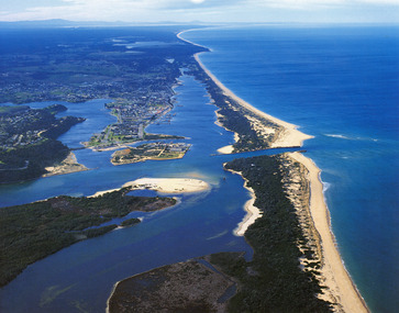 Lakes Entrance Historical Society
Photograph - Lakes Entrance, 1985c
Photo was cut from Tourist brochureColour photograph showing aerial view of township and the Ninety Mile Beach. Pecks factory on Bullock Island, Old North Arm bridge, bitumen for carpark for future. Fishermen's Club near North Arm Bridge. Photo shows East end of Rigby Island and Snake Island. Glimpse of Red Bluff, Lake Bunga and Lake Tyers in far east. Lakes Entrance Victoriabridges, coast, waterways, topography, township -
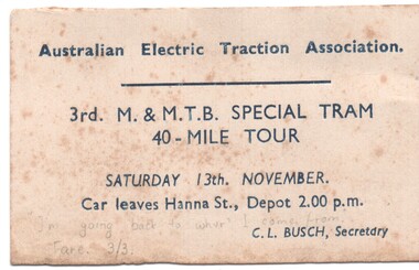 Melbourne Tram Museum
Ephemera - Ticket, Australian Electric Traction Association (AETA), Ticket for an Australian Electric Traction Association tram tour, Nov. 1965
Ticket for an Australian Electric Traction Association tram tour - 3rd MMTB special tram - 40 mile tour, for Saturday 13th November (no year given), leaving from Hanna St. depot (Sth Melbourne). C. L. Busch Secretary. Two copies held. A calendar check shows that 1948 was a Saturday 13/11. See Dec 1948 Tram Tracks for a tour reporttrams, tramways, aeta, tours, ticket, south melbourne depot, hanna st depot -
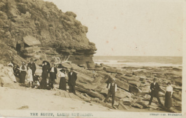 Lakes Entrance Historical Society
Postcard - Red Bluff 1910 c, Stanley Vogt, 1910c
Paired with image 03731.1 for display in 150 years Lakes Entrance 1858 to 2008 held in October 2008Sepia toned postcard west side of Red Bluff showing a group of eight men and five women and a child. Sand washed away exposing vast rocky beach, short vegetation on rocky bluff. Women wearing full length skirts and wide brim hats with veils, men in three piece suits dark in colour on ninety mile beach Lake Tyers VictoriaThe Bluff Lakes Entrancetopography, fashion -
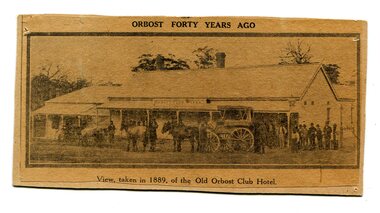 Orbost & District Historical Society
newspaper clipping, Orbost Forty Years Ago, 1929?
The first hotel built in Orbost was the Club in 1885 an old wooden place on the corner built for J. A. Petersen of the Mitchell Hotel Bairnsdale, with the licence in the name of Mr Thomas Maguire (stepson of Petersen). In June 1889 there was a rush to Mackenzie River, about 28 miles from Orbost, on Twelve Mile Creek. An estimated 80 men rushed the ground, but yields were patchy and large numbers eventually left. They were coming and going almost daily.The Club Hotel was the first hotel built in Orbost and remains a significant building in the town. It was an important hub for the township with many whole town meetings held there.A yellowed black / white newspaper clipping of a photograph of people with a horse and cart outside a one-storey hotel building. It is glued onto a piece of cardboard.Caption at bottom - "View taken in 1889 of the Old Orbost Club Hotel"orbost-club-hotel -
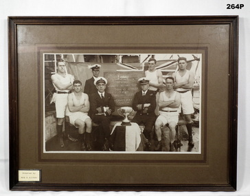 Bendigo Military Museum
Photograph - PHOTOGRAPH, FRAMED, Hook, Ray, Frame, 1.3.1938
On the plaque board centre of group, “HMAS Sydney/winners victory cup/seamen’s whaler/2 miles/Australian fleet ??/Hervey bay/June 1926”Framed photograph, timber fame, brown colour, sepia tone photo of 8 RAN Sailors with a silver award cup depicting the “Winners Victory cup 1926, photo mounted on dark brown card , donation label on front, framing label on back.On label card black type, “Donated by Mrs E Aitken” On back handwritten in black, “Mrs E Aitken”photography-photographs, frames, military ran -
Mission to Seafarers Victoria
Letter - Correspondence, 30/07 /1951
Allan writes of his week's holiday in a log cabin on top of a mountain 120 miles east of Oslo and describes countryside and the beautiful view of the valley below.Quinn CollectionA self-folding letter part typed, part written in green ink (0881.a) headed Oslo and dated 30/07/51. It is addressed to Mrs K Hayes, 14 Fitzroy Street, St Kilda, Victoria, Australia. The return address is Allan Quinn, C/- General Delivery, G.P.O. Oslo. There are some penciled numbers on the right of and below the return address.letters-from-abroad, allan quinn, norway, oslo, alette andersen -
National Wool Museum
Medicine container
Manufactured by Foster McLellan Co., Sydney. Collection originally owned by Strauss family of Waverley Rainbow (on road to Lake Albaculya, 12 miles from Rainbow).Doan's Backache Kidney Pills (label) -
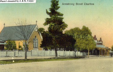 Charlton Golden Grains Museum Inc
Photograph, St Martin's Anglican Church, Armstrong St Charlton
St Martin's Anglican Church was built in 1889. Victoria Hall was built for E. Miles in 1884. The post card is part of a series taken c. 1907.Copy of a coloured (hand coloured?) post card showing St Martin's Anglican Church, Armstrong St, Charlton. The church is a yellow, timber building with a cross at each end of the roof. A white picket fence runs along the front of the church. There are three trees on the edge of the road in front of the church. There is a large single storey red brick building to the right of the church with a verandah over the footpath. A horse is coming down the road past the red brick building. The post card has Armstrong Street Charlton in the top right. There is a typed note in the top LH corner of the photo that says Photo's donated by J. & K. Cossar.pastoral care, st martin's, angllican, church, armstrong street, charlton -
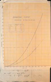 Melbourne Tram Museum
Drawing - Braking Curve, Melbourne & Metropolitan Tramways Board (MMTB), c1920
Set of two documents: 1 - Braking chart for a retardation or deceleration of 4 ft/sec/sec - for miles per hour and distance in feet. 2 - calculations for above.Yields information about braking distances for various speeds.Set of two documents - on quarto graph paper and hand written foolscap sheet.trams, tramways, brakes, braking -
 Warrnambool and District Historical Society Inc.
Legal record - Letter Book, G.S. Mackay, Circa 1920
This book contains private letters which G. S. Mackay wrote to his daughter, Meta? and his aunt in the 1920’s. G. S. Mackay was born in Sutherlandshire Scotland in 1850. He qualified as a solicitor and came to Australia in 1884 and later to Warrnambool in 1893. He served as a Warrnambool City Councillor and also held a number of important positions within the Presbyterian Church. He was one of the earliest and strongest supporters of the Warrnambool High School. Many of the letters within this book are to his daughter who studied medicine in Glasgow in the early 1900’s. G. S Mackay was prominent in legal, civic and religious life in Warrnambool almost from the time of his arrival in 1893 until his death in 1926. Many of these letters are of a religious nature and as such display that aspect and personal thoughts of Mr Mackay’s personal life. Dark green fabric cover with light brown suede spine and cover edges. Hard cover. Green patterned paper inside front and back covers. Alphabetical index at front. Pale fine yellow pages numbered up to 502. L. ****Queen Douglas, Newpark West Calder, MidLothian 14 miles from Edin’h Ry Stn Newpark. Meta Selby The Calouda(?) Club 35 St Georges Square London S.W.1 warrnambool, g.s. mackay letter book, solicitor, g. s mackay councillor. -
 Ringwood and District Historical Society
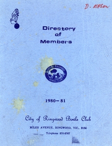
Booklet, Ringwood Bowls Club- Directory of Members, 1980-81
Blue coloured bookletOn front cover Directory of Members, 1980-1981 City of Ringwood Bowls Club Miles Avenue, Ringwood, Vic, 3134. Inside booklet is typed list of Members in alphabetical order with address and phone number. -
 Geelong Cycling Club
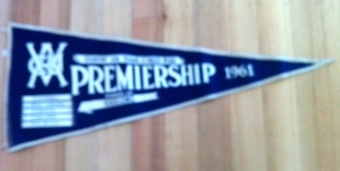
Pennant Flag, 1961
The 1960s followed a period through the 1950s when Geelong gave the Empire Games and Olympic Games representatives. 1961 sees D Wilson - an Olympian - appear this decade. The 1970s will again supply Olympic and Commonwealth Games representatives to Australia.Geelong Cycling Club supplies representatives to Australia in the Olympic and Commonwealth Games .Triangular blue felt pennant flag bordered in white felt. It has the VACU insignia stamped in white and inscriptions of the details of the race and race winners stamped in white on it."VACU/Country Junior Teams 15 Miles Road/Premiership/1961/Runners-up/Geelong/B Murrell/L PArish/D Wilson/G Hanson/F Williams/Time:38:20.6"vacu; country junior teams; 15 miles road race; premiership; 1961; runners-up; geelong cycling club; b murrell; l parish; d wilson; g hanson; f williams; -
 The Beechworth Burke Museum
Photograph - Photograph - Reproduction, W. D. Gibbon, Early 1900s
This photograph was taken in 1911 at Three Mile Creek, about five kilometers south of Beechworth town. Significant digging took place at this location from late 1855, which led to a flood of workers and stores to follow, though daily earnings were slim compared to the nearby Woolshed site. This remained the case even after workers at Three Mile Creek attempted to protest around Beechworth during an election in November 1855. Three Mile Creek was one of seven significant divisions of the Beechworth Mining District formalised by the Governor-in-Council in 1858, though by the time this photograph was taken, the boundaries of the original seven districts had shifted to create seventeen divisions. The Three Mile Goldfields was a site of rich alluvial gold deposits located about 5km south of Beechworth in Victoria. Today, the location of this gold deposit is called Baarmutha. It was a popular area for gold mining in the 1850s but became largely abandoned by the following decade. In 1865, a man named John Pund (a man second from the left in the back row of this photograph shares this surname) recognized that the area could be potentially rich if a better water supply could be obtained. He secured a 15 year license with three other miners. Within the next five years, these men had constructed 19 km of water race going from Upper Nine Mile Creek to Three Mile Creek. By 1881, these four men had delivered 950,000 gallons to the Three Mile Sluicing area which is depicted in this photograph. Pund would later go into partnership with John Alston Wallace who would become owner of the Star Hotel in Beechworth. The Three Mile sluicing location continued to be operational until 1950. The eleven miners in this photograph are: Back row: Led Guthrie, P. Pund, F. Beel, [Unknown] Miller Front row: Paddy McNamara, J. King, W. Beel, [Unknown] Garland, J. Clarke, J. Ryan, H. Bartsh In the background of the photograph is a huge dirt wall that appears to suffer damage caused by hydraulic sluicing. Hydraulic sluicing is a specialised mining technique that involves directing high pressure water flows at dirt to uncover gold. The technique played a significant role in shaping Beechworth's landscape during the gold rush to create the topography seen today.The search for gold is ingrained into the history of Victoria and therefore, images like this one which portray an open cut sluicing site can reveal important information for society and technology for the date when the photograph was taken. This image is of important historical significance for its ability to convey information about sluicing and the methods used to find gold in the late 1800s and early 1900s. It also shows a location where sluicing was undertook which provides insight into the impact of sluicing on the environment at a time when it was done. Images, like this one, of Australian gold rush history can reveal important information about the social and environmental impact of this period. This image depicts diggers standing in a mining location and therefore, this image has the capacity to reveal or support significant information for researchers studying the fashion and social status of diggers in Australia in approximately 1911. It can also provide information on the landscape of Australia in this period and the impact of mining for gold on both society and the Australian landscape. The Burke Museum is home to a substantial collection of Australian mining photographs which can be used to gain a deeper understanding into life on the gold fields, technology used in mining, the miners themselves and the impact of the gold digging on the environment.Black and white / sepia rectangular reproduced photograph printed on glossy photographic paper mounted on board.beechworth, beechworth museum, mining, mining team, three mile creek, sluicing, hydraulic sluicing, photography, gold sluicing, gold mining, pund mining