Showing 999 items
matching name changes
-
 Eltham District Historical Society Inc
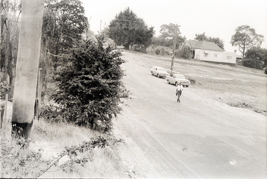
Photograph, Sherbourne Road, Para Road and Simms Road at Briar Hill/Montmorency prior to the upgrade of Sherbourne Road Railway bridge, c.1970
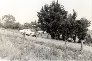
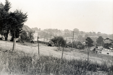
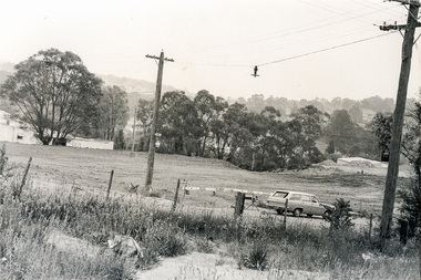
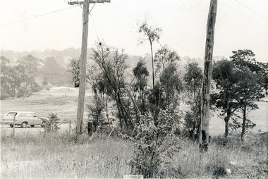
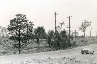
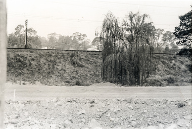
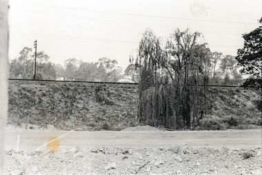
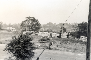
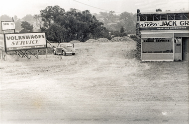
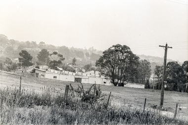
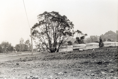
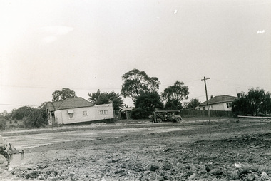
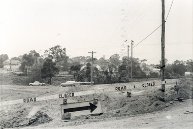
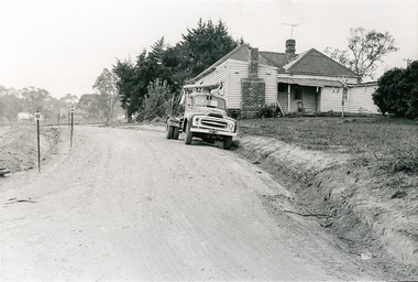
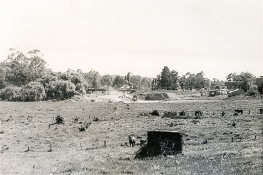
Collection of photographs probably taken around the same time depicting Sherbourne Road, Para Road and Simms Road at Briar Hill/Montmorency prior to the upgrade of Sherbourne Road Railway bridge, c.1970. Photo 01648_ 19 This home owned by Mrs Cameron. Her daughter married a Mr Davey, for whom Davey Road was named - email from M. Jones 20/07/2015 Photographer unknownThese photos are very significant in the documentation of the development of the Briar Hill and Montmorency areas and the changes in the physical landscape along the railway line area.20 black and white prints 9 cm x 13 cm.1970, briar hill, davey road, montmorency, para road, cameron, davey, sherbourne road, simms road, railway line, roadworks -
 Eltham District Historical Society Inc
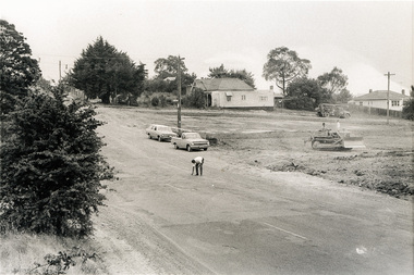
Photograph, Sherbourne Road, Para Road and Simms Road at Briar Hill/Montmorency prior to the upgrade of Sherbourne Road Railway bridge, c.1970
Collection of photographs probably taken around the same time depicting Sherbourne Road, Para Road and Simms Road at Briar Hill/Montmorency prior to the upgrade of Sherbourne Road Railway bridge, c.1970. Photo 01648_ 19 This home owned by Mrs Cameron. Her daughter married a Mr Davey, for whom Davey Road was named - email from M. Jones 20/07/2015 Photographer unknownThese photos are very significant in the documentation of the development of the Briar Hill and Montmorency areas and the changes in the physical landscape along the railway line area.20 black and white prints 9 cm x 13 cm.1970, briar hill, davey road, montmorency, para road, cameron, davey, sherbourne road, simms road, railway line, roadworks -
 Eltham District Historical Society Inc
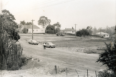
Photograph, Sherbourne Road, Para Road and Simms Road at Briar Hill/Montmorency prior to the upgrade of Sherbourne Road Railway bridge, c.1970
Collection of photographs probably taken around the same time depicting Sherbourne Road, Para Road and Simms Road at Briar Hill/Montmorency prior to the upgrade of Sherbourne Road Railway bridge, c.1970. Photo 01648_ 19 This home owned by Mrs Cameron. Her daughter married a Mr Davey, for whom Davey Road was named - email from M. Jones 20/07/2015 Photographer unknownThese photos are very significant in the documentation of the development of the Briar Hill and Montmorency areas and the changes in the physical landscape along the railway line area.20 black and white prints 9 cm x 13 cm.1970, briar hill, davey road, montmorency, para road, cameron, davey, sherbourne road, simms road, railway line, roadworks -
 Eltham District Historical Society Inc
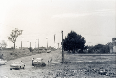
Photograph, Sherbourne Road, Para Road and Simms Road at Briar Hill/Montmorency prior to the upgrade of Sherbourne Road Railway bridge, c.1970
Collection of photographs probably taken around the same time depicting Sherbourne Road, Para Road and Simms Road at Briar Hill/Montmorency prior to the upgrade of Sherbourne Road Railway bridge, c.1970. Photo 01648_ 19 This home owned by Mrs Cameron. Her daughter married a Mr Davey, for whom Davey Road was named - email from M. Jones 20/07/2015 Photographer unknownThese photos are very significant in the documentation of the development of the Briar Hill and Montmorency areas and the changes in the physical landscape along the railway line area.20 black and white prints 9 cm x 13 cm.1970, briar hill, davey road, montmorency, para road, cameron, davey, sherbourne road, simms road, railway line, roadworks -
 Eltham District Historical Society Inc
Newsletter, Newsletter, No. 83 March 1992
Contents: • Next meeting, guest speaker; Gordon Ford: My Eltham • Annual General Meeting • Victorian Heritage Festival • Society’s 25th Anniversary • Committee of Eastern Historical Societies • Eltham Campers • More Brief Items • Nothing Ever Changes The Shire of Eltham Historical Society was formed in October 1967. The first newsletter of the Society was issued May 1978 and has been published continuously ever since on a bi-monthly basis. With the cessation of the Shire of Eltham in late 1994, the Society's name was revised to Eltham District Historical Society and this name first appeared with issue No. 103, July 1995. The collection of the Society's newsletters provides a valuable resource on the history of the Society's activities, office bearers and committee members, guest speakers and subjects of historical interest pertinent to the former Shire of Eltham and the Eltham District.A4 photocopied newsletter distributed to membersnewsletter, eltham district historical society, shire of eltham historical society -
 Eltham District Historical Society Inc
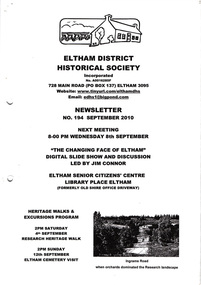
Newsletter, Newsletter, No. 194 September 2010
Contents: • Next meeting, Slide Show and Discussion led by Jim Connor: The Changing Face of Eltham • September Meeting • Research Heritage Walk • Eltham Cemetery Visit • Distinguished Life Members by Jim Connor • Jock Read’s Early History • Local Road Names; The North-South Roads • More News The Shire of Eltham Historical Society was formed in October 1967. The first newsletter of the Society was issued May 1978 and has been published continuously ever since on a bi-monthly basis. With the cessation of the Shire of Eltham in late 1994, the Society's name was revised to Eltham District Historical Society and this name first appeared with issue No. 103, July 1995. The collection of the Society's newsletters provides a valuable resource on the history of the Society's activities, office bearers and committee members, guest speakers and subjects of historical interest pertinent to the former Shire of Eltham and the Eltham District.A4 photocopied newsletter distributed to membersnewsletter, eltham district historical society, shire of eltham historical society -
 4th/19th Prince of Wales's Light Horse Regiment Unit History Room
Red Ensign, Surgeons' Banner, 1850 (estimated)
Red Ensign 1801 design. - The British red ensign was altered in 1801 to include the change to the design of the Union Jack. British legislation required, with a few exceptions, that all merchant shipping throughout the British Empire fly the British Red Ensign, without any defacement or modification. The ensign is sometimes referred to as the red duster. The Royal Navy stopped using the Red Ensign in 1864. This red ensign was used by the Surgeons of the Kyneton District Mounted Rifles to indicate their location. The Banner is a large red ensign mounted on a 10 foot long polished wooden pike. The Banner was used by the Kyneton District Mounted Rifles, later The Royal Volunteer Cavalry Regiment (Prince of Wales Hussars), then Prince of Wales Victorian Light Horse, ancestor units of the modern day 4th /19th Prince of Wales’s Light Horse Regiment. In the binding is the inscription ‘Kyneton Prince of Wales Light Horse’ and three names: Surg-Major S Smith MRSLE, Dr McMillan, and Maj Thirkettle. These surgeons played a significant role in the military and civil affairs of Kyneton. Dr McMillan Dr McMillan was the first surgeon but left KPWLH 2-3 months after its formation and little else is known of him. Surgeon-Major Samuel Smith 1836 Born, Scotland 1857 Surgeon to the Hon. Hudson Bay Company. Ship “Prince Arthur” from London to Moose Fort, Hudson Bay. June 13 – Aug. 24 1857. 1858 Appointed Medical Officer of large immigrant ship to Port Phillip 1859 Appointed Assistant District Coroner, Castlemaine 1859 Appointed to Castlemaine Hospital 1862 Appointed first resident surgeon and manager of Kyneton Hospital Foundation member of Kyneton District Mounted Rifles 1874 Appointed Surgeon-Major Kyneton Volunteer Prince of Wales Light Horse Conducted a private practice in Kyneton. 1909 Died 8 November 1909, aged 73 years Samuel Smith was a Life Governor of Castlemaine Benevolent Asylum, a member of St Andrews Presbyterian Church, a Mark Master Mason of the Edward Coulson Lodge No 17, Kyneton. He also had a notable collection of stuffed native birds and animals of which he had great knowledge. Major Thirkettle 1855 Major Thirkettle arrived in Kyneton Established a timber merchant and ironmongery business in Kyneton with Robert Burton. 1857 By 1857 he was practising as an architect. His house is still standing in Yaldwin St, West Kyneton. 1860 Joined the Prince of Wales Light Horse 1863 Joined Rifle Volunteers and appointed Captain. On their disbandment he was made Honorary Major. 1864 Won Queen’s prize for rifle shooting. Major Thirkettle was noted for his skill with woodwork. He won many prizes and orders of merit for his models of yachts It is believed likely that he made the wooden pike with its metal head (now missing). He was Tyler of the Zetland Lodge, also Secretary of the MUIOOF and Bowling Club. 1904 Died in Kyneton, aged 75 years Protection for medical services The Surgeons’ Banner indicated the location of the Regimental Aid Post. The use of this device in the 1860’s overlapped the adoption of the Red Cross which became the symbol for the protection of sick and wounded soldiers. In 1864 twelve European nations signed a treaty stating that in future wars they would care for all sick and wounded military personnel, regardless of nationality. They would also recognise the neutrality of medical personnel, hospitals and ambulances identified by the emblem of a red cross on a white background. The treaty was called the Geneva Convention. This Convention was concerned only with soldiers wounded on the battlefield. Over the years, however, it has been expanded to cover everyone caught up in conflicts but not actually taking an active part in the fighting. The Surgeons’ Banner complements the Colours of the Kyneton District Mounted Rifles, also held by the Unit History Room, in presenting the colonial period of the Regiment’s history. Provenance It is believed that the Banner was manufactured in Britain and brought to Australia by Samuel Smith. After the disbanding of Colonial units, the Banner was in the care of the Shire of Kyneton until presented to the 4/19 Prince of Wales’s Light Horse Regiment on 14 September 1986 on the occasion of the Regiment exercising its right of freedom of entry to the city. There are many examples of Regimental and King’s/Queen’s Colours held by various organisations. However A Surgeons’ Banner such as this is rare, if not unique, in Australia. A large red ensign, post 1801 design. - The British red ensign was altered in 1801 to include the change to the design of the Union Jack. British legislation required, with a few exceptions, that all merchant shipping throughout the British Empire fly the British Red Ensign, without any defacement or modification. The ensign is sometimes referred to as the red duster. The Royal Navy stopped using the Red Ensign in 1864. On the binding is the inscription: "Kyneton Prince of Wales Light Horse", and three names - Surgeon Major S Smith MRSLE Dr McMillan Major Thirkettlekyneton district mounted rifles, heraldry, red ensign, surgeons banner -
 Kiewa Valley Historical Society
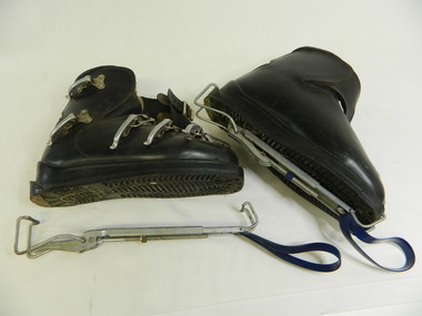
Ski Boots - Downhill, c1970
These boots were used for downhill skiing. Metal clips were used to tighten the boots across the foot and ankle. They were attached to the skis with bindings. The straps enable the boots to hang to dry after use. Doug McConville used them in the Winter Olympics in 1974.Historical: Doug McConville was an Olympian Ski boots change with the development of technology. These haven't a brand name on them.These black leather boots are made in Germany. They are lambswool lined. There is a quick release ankle metal spring clip attached to the sole with a blue looped strap of fabric at the toe end for hanging. There are 3 metal clips across the foot and 2 around the ankle for tightening the boot on to the foot. The boots have heavy plastic soles.Made in Germanywinter sport, ski, snow, boots, downhill skiing, alpine, winter olympics -
 Kiewa Valley Historical Society
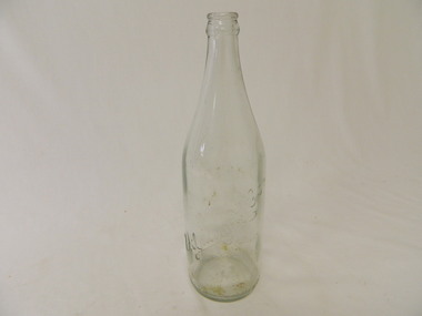
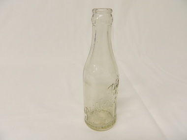
Bottle - Soft Drink, c1940s
Soft drink came in bottles bought at the local grocery store or at a larger city store on a shopping expedition. The shape of the bottles changed as did the stopper used to seal it. Bottles were re cycled remaining the property of the manufacturer. The history of Zedmanfg Company, Albury. Historical: Change of bottles - shape, glass, stopper, embossing, use. Aesthetic: Display showing embossing & shape especially if in good condition. Clear glass bottle. Bottom half has straight sides. Upper half tapers to the top where a metal crimp fits over the lip. Manufacturer's name is heavily embossed in cursive script diagonally across the lower half. The place 'Albury' is embossed below the diagonal script, in capital letters.There is heavy embossing at the base and at the bottom of the sides. All in capital letters. It has a crown seal - AGMZedManfg Co. Albury - across the bottom half of the bottle. At the base on the sides around the circumference 'This bottle is the property of the Zedmanfg Co. Albury. On the Base: F1486, GM inside A, M 113 glass, bottle, domestic, household, albury, zedmanfg co., drinks, lemonade -
 Kiewa Valley Historical Society
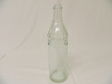
Bottle - Soft Drink, Late 1920's - 1930's
Soft drink came in bottles bought at the local grocery store or at a large city store on a shopping expedition. The shape of the bottles changed as did the stopper used to seal it. Bottles were re-cycled remaining the property of the manufacturer. History of Phibbs Bros., Albury.Historical: Change of bottles - shape, glass, stopper, embossing, use. Aesthetic: Display showing embossing, shape and size.Small clear glass bottle with heavy embossing. The straight sides go half way up then taper to the opening. The manufacturer's name is written diagonally across one side with 'Albury' printed in capital letters underneath. On the same side three lines of words are printed in capital letters. The base has light embossing.Side: 'Phibbs Bros / Albury' Side around the bottom: 'This Bottle / Is the Property of / Phibbs Bros Albury'bottle, ginger beer, soft drink, phibbs bros albury, drink, household -
 Kiewa Valley Historical Society
Bottle - Spirits, 1940's
Whisky came in bottles sold at licensed premises either locally or in larger cities visited during shopping expeditions. The shape of bottles varied. Bottles were recycled remaining the property of the manufacturer who paid for their return. History of James Dickson Co. Pty. Ltd.Historical: Change of Bottles - shape, glass, embossing. Collected by bottle collectors. Aesthetic: Display showing embossing and shapeClear glass whisky bottle with heavy embossing on one side where the maker's name and details is printed in capital letters longitudinally. Heavily embossed zig zag pattern at the top of straight sides that go three quarters of the way up. The sides taper to the neck which has straight sides to the screw top opening. The tapered section is grooved with ridges of straight lines to a lip which is between it and the neck. Side (longitudinally): 'This Bottle is the Property of / James Dickson & Co. Pty Ltd / Established 1854 / Melbourne Aust. / And Cannot Be Legally Used By Others' Base: 'A' above 'F892' and 'M' beneath. Reading from the inside of the bottle on the base is 'E41' whisky, bottle, spirit, james dickson co. pty. ltd -
 Kiewa Valley Historical Society
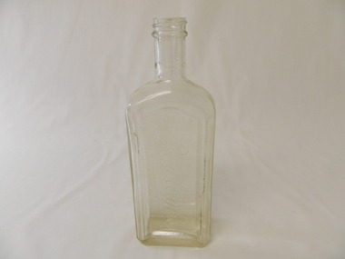
Bottle - Chemist, 1930's - 1940's
This bottle was bought at the local chemist or a chemist in a larger city on a shopping expedition. The shape of the bottles changed as did the stopper used to seal it. History of Rawleigh's.Historical: Change of bottles - shape, glass, stopper, embossing, use Aesthetic: Display showing embossing and shape.Clear glass bottle with rectangular base and straight sides three quarters of the way up tapering into the neck and then the screw top opening. The front face is heavily embossed with maker's name signed across the face. The back and side faces are flat while the front is indented and framed with a curved top. The base is embossed and slightly indented.Front side: "I Rawleigh's I" Base: Common seal 'A' with 'G' on top and 'M' underneath inside the 'A', 'G437' and an 'O'chemist, rawleigh's, medicine, glass bottle -
 Kiewa Valley Historical Society
Photos - Mt Beauty Schools
Mt Beauty HES school was created for the children of the employees of the State Electricity Commission of Victoria who were constructing the Kiewa Hydro Electric Scheme at the head of the Kiewa Valley at the new town of Mount Beauty. Mt Beauty School consisted of Mt Beauty Higher Elementary School 1948-1964 before it was split into the current (2023) Mt Beauty Primary School and Mt Beauty High School. See. "Kiewa Kids" by Graham Gardner pages 94-180. "Below Bogong-A History of Mount Beauty" compiled by Di Edmondson. chapter 7, Pages 178-230.As the population changed so did the schools in name, size etc. Also what started as a very modern school in the 1948 to what is now an older style wooden building2 larger photos 1 b & w - hurdles race and 1 colored 3 girls sitting in front of computers 9 medium size photos 1 b & w students and 1 of car; 1 of school building and 1 of student group; 5 coloured sports daymt beauty higher elementary school -
 4th/19th Prince of Wales's Light Horse Regiment Unit History Room
Medal, Long Service and Good Conduct Medal
The British Army Long Service and Good Conduct medal was instituted in 1830. The medal is made from silver and is 36 millimetres in diameter. Until 1901 the medal's obverse contained an image of a trophy of arms with the Royal Arms in an oval shield in the centre while the reverse side contained the inscription "For Long Service and Good Conduct". The King William IV issue had the Royal Coat of Arms with the badge of Hanover on the obverse and a small suspension ring with a plain crimson ribbon. The small ring was replaced by a larger version in 1831. When Queen Victoria succeeded to the throne in 1837 the Hanover emblem was removed from the medal's obverse. In 1855, during the Crimean War, a swivelling scroll suspension was introduced similar to that on the Crimea Medal, followed in 1874 by small lettering replacing the original large lettering on the reverse side. On the succession of King Edward VII to the throne in 1901, the effigy of the reigning sovereign was placed on the medal's obverse. The reverse side remained unchanged, while in 1920 the swivelling scroll suspension was replaced by a fixed suspender. In 1930 the title of the medal was changed to the Long Service and Good Conduct (Military) Medal. It was also decided to add a fixed suspension bar bearing the text "Regular Army" or the name of a dominion country: Australia, New Zealand, Canada, India or South Africa. The medal was originally awarded to soldiers of good conduct who had completed 21 years service in the infantry or 24 years in the cavalry. In 1870, this qualifying period was reduced to 18 years for both the infantry and cavalry. During World War II officers could also be awarded this medal if they had completed at least 12 of their 18 years service in the ranks. Today, the Long Service & Good Conduct Medal (Army) is awarded to members of the British Army who have completed 15 years of reckonable service. A soldier who completes 15 years of reckonable service from the date of attestation or age 17½, whichever is later, shall be eligible to receive the medal. However, there are a number of offences which would normally preclude award of the LS&GCM. Awards are only made after a thorough check of a soldier's record of service. A Clasp to the medal was introduced in 1940. This can be awarded for an additional fifteen years' service. The Clasp bears an image of the Army Crest. When the ribbon alone is worn on a uniform a silver rosette denotes the award of the Clasp. The medal's ribbon was plain crimson from 1830 until 1917 when white stripes were added to both edges. An officer can be considered eligible for the award of the LS&GCM if 12 or more of the 15 years of his or her service have been in the ranks and provided that the other requirements for the award of the medal have been met. An Officer shall be eligible for the award of the Clasp if 22 or more of the 30 years of his or her service has been in the ranks and provided that the other requirements have again been met. Before 1 December 1977 18 years of service was required for consideration for the LS&GCM (Army). The vast majority of LS&GC medals are issued named to the recipient, with the name on the rim around the medal.Full size medal with ribbonREGULAR ARMY Recipient details on rim - not decipherablemedal long service good conduct -
 Eltham District Historical Society Inc
Ledger, Eltham Road District. Assessment for the Year ending Oct. 14th, 1860 (Version 2), 1859c
The Eltham Roads Board was established in 1856. This is a unique significant record of early settlers in the Shire of Eltham. One of 6 early rate books. This is among the oldest items in the EDHS collection. An article in the Eltham and Whittlesea Shires Advertiser Friday 21 Nov 1941 Page 5 titled: District's Early History states: "The first rate book which is still in existence at the Shire Office is for the year ending October 14, 1858 and is probably the best record possible to indicate the development of the district. At the time properties were rated as follows: Cultivated land. 6d. per acre; pasture land, 1d. per acre: estimated annual value of buildings, etc., 6d in the (pound). The total amount of rate recorded for the year was (pounds)153/14/8. Properties were described as being situated at Lower Plenty, Yarra Yarra, Eltham, Lower Eltham, Kangaroo Ground, Yarra Flats, Diamond Creek and the Yarra."Ledger with printed columns: Number, Name of Occupier, Description, Where situated, Cultivated land, Pasture land, Estimated annual value of buildings, Rate, Remarks, Arrears collected, excused, unoccupied, uncollected and amount actually collected. Ledger filled out by hand with 177 entries (not alphabetically arranged). A number of blank pages are included. This version was slight changes to version one. Inside cover includes pasted printed note: RATE OF ASSESSMENT AS FOLLOWS: Cultivated land 6d per acre Pasture land 2d per acre Unalienated Pasture Land 8d per Acre Estimated Annual Value of Buildings, &c., 6d. in the Pound eltham roads board, rate book, rate payers, transaction, pioneers, settlers, 1860, assessment ledger, eltham road district, public records office victoria (prov), rate books, shire of eltham archives