Showing 4366 items matching "process"
-
 Warrnambool and District Historical Society Inc.
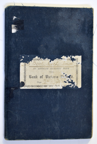
Financial record (Item) - Warrnambool Mechanics Institute & Free Library Bank of Victoria Bank Book, The Bank of Victoria Limited Warrnambool, 1904-1911
The Bank of Victoria was located at 7a Liebig Street, Warrnambool. The building still exists in 2023 as a part of the Quest apartments. The Warrnambool Mechanics' Institute was formed in 1859 and the first reading room opened in 1884. Responsibility for all activities of the Warrnambool Mechanics' Institute activities were formally handed over to the Warrnambool city Council on 27th July 1911. This Bank of Victoria Limited passbook documents credits and debits of the Warrnambool Mechanics' Institute & Free Library from December 1904 until 30th June 1911 just prior to the transfer to the Warrnambool City Council. This passbook is an example of how banking records were kept in the early 20th century. W'Bool. Mech. Inst. in Account with the Bank of Victoria Limited. Page 742 783warrnambool mechanics’ institute library, bank of victoria, warrnambool -
 Federation University Historical Collection
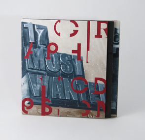
Booklet - Exhibition Catalogue, 17 Most Wanted, 1996
Separate to the combined Visual Arts exhibition held at the Mt Helen Campus, the third year graphic design exhibition ran from 15 to 24 October 1996 at the ANZ Gothic Bank, Corner Collins and Queen Street, Melbourne. Exhibition opened by invitation on Tuesday 15 October 1996 at 6.00pm. The brochure features "mug shot" style photos of each student along with their name and (presumably) birth year. See item 29161.3 (CD Rom) for further information and screen captures.University of Ballarat, Bachelor of Art (Graphic Design) Graduate Exhibition and promotional material, 1996. 20pp concertina fold brochure, four colour process offset print plus varnish.university of ballarat, federation university, graphic design, mark molloy, hilario vila pouca, gavin nash, robert connelly, paul lynch, ross morgan, w hewitt, j patella, j jones, r braybrook, t roth, c dorrington, b tiley, k mibus, j rowland, k gration, b marshall -
 Invermay Local History Association
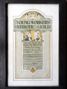
Framed Award Certificate, Unknown framer, Young Workers' Patriotic Guild, Certificate issued by Victorian Education Dept 1918
Paper certificate under glass plate in timber frame. Ornate certificate printed using four colour process, portrait format. Features very simple, dark stained frame.The certificate features wording certifying 'that during the Great War Neta Greening, a pupil of Invermay School No. 882 qualified as an effective member' of the Young Workers' Patriotic Guild [Victoria]. Certificate no. 13,422 issued 1918. Signed by W. Hutchinson, Minister; F. Tate, Director [VED] and Miss I. Ryrie, Headmaster. -
 Bendigo Historical Society Inc.
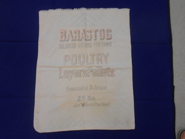
Textile - CALICO STOCK FEED BAG, 1950s
Textiles. Calico bag. Printed on one side in black and pink, ''BARASTOC''.''Balanced rations for stock'', ''Poultry Layers Pellets'', ''Processed at St. Arnaud'', ''25 lbs When Packed''.textiles, domestic, calico stock feed bag -
 Whitehorse Historical Society Inc.
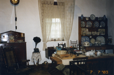
Photograph, Cottage kitchen, 7/07/2003 12:00:00 AM
Coloured - Interior of cottage kitchen to be used in the book - 'Schwerkolt Cottage and Museum: the legacy of Johann August Schwerkolt, Pioneer' by Ted Arrowsmith which is in the process of being printed by the City of Whitehorseschwerkolt cottage and museum complex, arrowsmith, ted, city of whitehorse -
 St Patrick's Old Collegians Association (SPOCA)
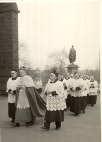
Photograph - Teachers, Jesuits
-
 Federation University Historical Collection
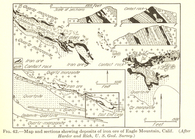
Book, William Harvey Emmons, The Principles of Economic Geology, 1940, 1940
The book was used by Charles Bacon who studied at the University of Nevada in the late 1930s/early 1940s. Bacon worked at Bunker Hill Mines and Kellogg Idaho, before arriving in Australian in 1951. He worked for CN Myers, a company involved with paper converting. CN Myers was a family business (on Charles Bacon's maternal line). William Emmons was Professor and head of Geology and Mineralogy at the University of Minnesota; Director of Minnesota geological Survey; and previously Geologist, Section of Metalliferous Deposits, United States Geological Survey.Maroon soft covered book of 529 pages. Chapters include Magmatic Segregations, Pegmatities, Hypothermal Deposits, Sedimentary Depostis, Openings in Rocks, Metasomatic Processes, Mineral Associations and more.Inside front cover "Charles Bacon 1940 Lincoln Hall Ass. University of Nevada Reno, Nevada"charles bacon, mining engineering, metallurgy, university of nevada, mackay school of mines, geology, california -
 Lakes Entrance Historical Society
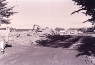
Photograph - Pecks factory, Fish Marie, 1995c
Black and white photograph, heavy machinery clearing the site of Pecks fish processing factory on Bullock Island, showing piles of broken concrete ready for removal. Lakes Entrance Victoriaislands, historic site -
 Kiewa Valley Historical Society
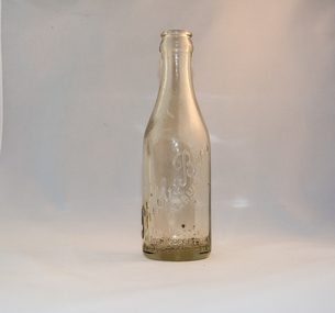
Bottle Ginger Beer, circa mid to late 1900's
This glass ginger beer bottle was manufactured and used early to late 1900's, until the time that cheaper containers were invented(plastic bottles). This bottle was so constructed to be easily moved within the ginger beer processing plants from the brewing vats/holding tanks to the final corking/sealing of the bottles for eventual distribution. From 1990s the bottle slowly became phased out of production however boutique suppliers still preferred thick glass to contain any explosive action. Two major glass bottle works companies, e.g. Australian Glass Manufacturers and the Melbourne Glass Bottle Works Co. were the main suppliers for the Victorian State.In the period when this bottle was manufactured and used the major ginger beer brewing plants for the whole of Victoria were located in Melbourne because this was where its greatest consumer base was there and most rural areas were supplied by domestic sources (mother brewing ginger beer for the children). The Kiewa Valley and its region was one rural area which until road invrastructure was enhance covered the ginger beer thirst by local family production. As the population expanded considerably in the late 1940's (SECV Hydro Scheme) with a greater demand for "soft" drinks" being established supplies from larger towns and cities were call for. Each bottle was "branded" during manufacturing to show the contents were from a reputable supplier (PHIBBS Bros) and where it originated from. These bottles were recycled by the manufacturer as a way to cut production costs. This method of recycling the bottles back to the specific manufacturer has (except for South Australia)been overtaken by a no cost recycling collection by councils (funded by their communities). This method by passes the user cost principle as the bottles are processed as non generic. The uneconomical "on cost" which was replaced by the "throw away" less costly plastic containers however did not provide the keen domestic brewer of the "beer" with a reusable bottle.This heavy gauged glass bottle (Ginger Beer) has a rim and a distinctive head at the top. This head has been manufactured to facilitate the movement of the bottled along the production line. The method of pouring ginger beer into the bottle has been part of the "production line" process of automation. This bottle has a capacity to hold 250ml of ginger beer and is made from "clear" glass. The marority of ginger beer bottles produced in this time frame where made with a "green" tint in them.This tinting helped reduce the sunlight effecting the contentsAround the bottom side of the bottle and blown into the glass is "THIS BOTTLE IS THE PROPERTY OF PHIBBS BROS, ALBURY" above this, in "running script" and sloping up from left to right is "Phibbs Bros" and underneath parallel to it "ALBURY". On the base of the bottle is molded a big "L 289" underneath this "M" and below this "AGM".ginger beer bottle, soft drink bottles, cordial bottles -
 Port Melbourne Historical & Preservation Society
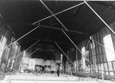
Photograph - Reconstruction, interior, Excelsior Hall, Port Melbourne, 2003
Gary Spivak was an officer of the City of Port Phillip involved with the reconstruction of heritage buildings to create low cost housing. this project was under his direction. B&W photos taken by Gary Spivak in 2003 during the construction process to turn Excelsior Hall into public housing units. 02 - Interior view showing bracing and original trussesbuilt environment - civic, town planning, heritage, excelsior hall, rsl, returned services league, public housing -
 Beechworth RSL Sub-Branch
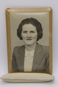
Photograph Prortrait - Irene Madeline Clark
Photograph possibly taken on before departing or returning from warPart of the Flynn family collection of Cpl William Charles ClarkPhotograph portrait in celluloid processed plaque. Photographed mounted on brown paper background. Corners of the plaque are expose the mounting paper. The photo plaque is attached to a metal frame with a wire clip for hangingOn self adhesive label; Irene Madeline Joyce / 27/2/19 - 28/9/1983 / Married / William Charles Clarke / 10/3/1934celluloid, photograph, irene madeline clark -
 Melbourne Legacy
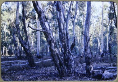
Slide, Operation Firewood - Red Gum Forest, Murray River, 1960s
Colour slide of red gum trees in a forest near the Murray River. It was during Operation Firewood. Legatees would organise collection of wood from the country and distribute it to widows in metropolitan Melbourne. More photos show the cutting and loading of wood and delivery to widows in metropolitan Melbourne. Was with many other slides taken in the 1950s and 1960s. The slides have been photographed to make digital images and moved to archive quality sleeves. In many cases the original images were not well focussed and the digital image the best available.A record of Legacy helping widows by sourcing, supplying and delivering firewood. When open fires were the main source of heating, a load of firewood and help moving it, would have been very important to the widows.Colour slide of trees in a Red Gum forest during Operation Firewood in brown Anscochrome cardboard mount. Printed on reverse in red ink 'Processed by Verycolor photo labs. Melbourne, Victoria'.Printed on front in red ink 'Anscochrome / View from this side / Made in Australia'. Hand written on front 'Red gum trees / River Murry' in blue pen.operation firewood, trees, forest -
 Eltham District Historical Society Inc
Negative - Photograph, J.A. McDonald, Eltham-Yarra Glen Road, Lower Plenty footbridge, Sep. 1955
The Eltham-Yarra Glen Road as designated originated at the Shire of Eltham boundary at the Plenty River. West of the river the road was known as the Heidelberg-Eltham Road. The section from the Plenty River is now known as Lower Plenty Road which becomes Main Road. The footbridge no longer exists but was originally sited to the south, adjacent to the old Lower Plenty Bridge, now part of the Plenty River Trail. Record of various Shire of Eltham infrastructure works undertaken during the period of 1952-1962 involving bridge and road reconstruction projects, sometimes with Eltham Shire Council Project Reference numbers quoted. It was during this period that a number of significant improvements were made to roads and new bridges constructed within the shire that remain in place as of present day (2022). In many situations, the photos provide a tangible visible record of infrastructure that existed throughout the early days of the Shire. The album was put together by or under the direction of the Shire Engineer, J.A. McDonald.1955-09, eltham-yarra glen road, lower plenty footbridge, lower plenty, lower plenty bridge, lower plenty road, main road, plenty river trail, bridge construction, infrastructure, shire of eltham -
 Eltham District Historical Society Inc
Negative - Photograph, J.A. McDonald, Eltham-Yarra Glen Road, Lower Plenty footbridge, Sep. 1955
Tony Carberry and J. Jolly The Eltham-Yarra Glen Road as designated originated at the Shire of Eltham boundary at the Plenty River. West of the river the road was known as the Heidelberg-Eltham Road. The section from the Plenty River is now known as Lower Plenty Road which becomes Main Road. The footbridge no longer exists but was originally sited to the south, adjacent to the old Lower Plenty Bridge, now part of the Plenty River Trail. Record of various Shire of Eltham infrastructure works undertaken during the period of 1952-1962 involving bridge and road reconstruction projects, sometimes with Eltham Shire Council Project Reference numbers quoted. It was during this period that a number of significant improvements were made to roads and new bridges constructed within the shire that remain in place as of present day (2022). In many situations, the photos provide a tangible visible record of infrastructure that existed throughout the early days of the Shire. The album was put together by or under the direction of the Shire Engineer, J.A. McDonald.1955-09, eltham-yarra glen road, lower plenty footbridge, j. jolly, lower plenty, lower plenty bridge, lower plenty road, main road, plenty river trail, tony carberry, bridge construction, infrastructure, shire of eltham -
 Eltham District Historical Society Inc
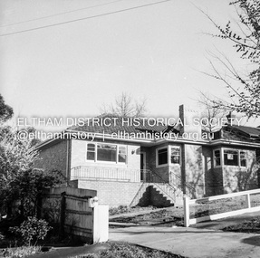
Negative - Photograph, J.A. McDonald, Newly built home, Sep. 1955
Street and location unidentified, possibly not Eltham though next immediate frame is Pryor Street and sun position appears to be similar indicating street (ealrly to mid afternoon) indicating street runs east west direction and camera view is to the south. Streets in Eltham are all even numbered on the south sideRecord of various Shire of Eltham infrastructure works undertaken during the period of 1952-1962 involving bridge and road reconstruction projects, sometimes with Eltham Shire Council Project Reference numbers quoted. It was during this period that a number of significant improvements were made to roads and new bridges constructed within the shire that remain in place as of present day (2022). In many situations, the photos provide a tangible visible record of infrastructure that existed throughout the early days of the Shire. The album was put together by or under the direction of the Shire Engineer, J.A. McDonald.1955-09, houses, shire of eltham -
 Eltham District Historical Society Inc
Negative - Photograph, J.A. McDonald, Eltham, Pryor Street, Sep. 1955
Construction of new concrete kerbing and footpath in Pryor Street, Eltham 18” tray and AG backing(?)Record of various Shire of Eltham infrastructure works undertaken during the period of 1952-1962 involving bridge and road reconstruction projects, sometimes with Eltham Shire Council Project Reference numbers quoted. It was during this period that a number of significant improvements were made to roads and new bridges constructed within the shire that remain in place as of present day (2022). In many situations, the photos provide a tangible visible record of infrastructure that existed throughout the early days of the Shire. The album was put together by or under the direction of the Shire Engineer, J.A. McDonald.1955-09, footpaths and gutters, pryor street, infrastructure, shire of eltham -
 Eltham District Historical Society Inc
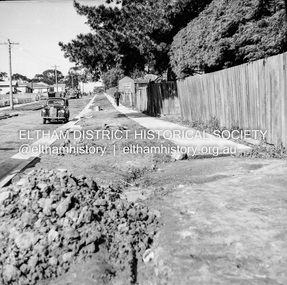
Negative - Photograph, J.A. McDonald, Eltham, Pryor Street, Sep. 1955
Construction of new concrete kerbing and footpath in Pryor Street, Eltham The truck on the left of the road is parked ouside the Eltham Police Station at No. 23. On the right is the present-day Woolworths carparkRecord of various Shire of Eltham infrastructure works undertaken during the period of 1952-1962 involving bridge and road reconstruction projects, sometimes with Eltham Shire Council Project Reference numbers quoted. It was during this period that a number of significant improvements were made to roads and new bridges constructed within the shire that remain in place as of present day (2022). In many situations, the photos provide a tangible visible record of infrastructure that existed throughout the early days of the Shire. The album was put together by or under the direction of the Shire Engineer, J.A. McDonald.1955-09, footpaths and gutters, pryor street, eltham police station, infrastructure, shire of eltham -
 Eltham District Historical Society Inc
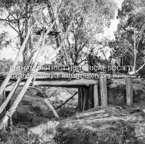
Negative - Photograph, J.A. McDonald, Pinnacle Lane, Steels Creek, Sep. 1955
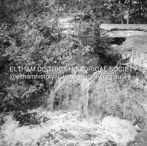
The old bridge looking downstream Record of various Shire of Eltham infrastructure works undertaken during the period of 1952-1962 involving bridge and road reconstruction projects, sometimes with Eltham Shire Council Project Reference numbers quoted. It was during this period that a number of significant improvements were made to roads and new bridges constructed within the shire that remain in place as of present day (2022). In many situations, the photos provide a tangible visible record of infrastructure that existed throughout the early days of the Shire. The album was put together by or under the direction of the Shire Engineer, J.A. McDonald.1955-09, pinnacle lane, steels creek, bridge construction, infrastructure, shire of eltham -
 Eltham District Historical Society Inc
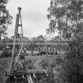
Negative - Photograph, J.A. McDonald, Pinnacle Lane, Steels Creek, Sep. 1955
The old bridge looking eastwardsRecord of various Shire of Eltham infrastructure works undertaken during the period of 1952-1962 involving bridge and road reconstruction projects, sometimes with Eltham Shire Council Project Reference numbers quoted. It was during this period that a number of significant improvements were made to roads and new bridges constructed within the shire that remain in place as of present day (2022). In many situations, the photos provide a tangible visible record of infrastructure that existed throughout the early days of the Shire. The album was put together by or under the direction of the Shire Engineer, J.A. McDonald.1955-09, pinnacle lane, steels creek, bridge construction, infrastructure, shire of eltham -
 Eltham District Historical Society Inc
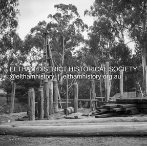
Negative - Photograph, J.A. McDonald, Pinnacle Lane, Steels Creek, Sep. 1955
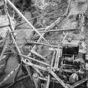
The old bridge from top of pile frameRecord of various Shire of Eltham infrastructure works undertaken during the period of 1952-1962 involving bridge and road reconstruction projects, sometimes with Eltham Shire Council Project Reference numbers quoted. It was during this period that a number of significant improvements were made to roads and new bridges constructed within the shire that remain in place as of present day (2022). In many situations, the photos provide a tangible visible record of infrastructure that existed throughout the early days of the Shire. The album was put together by or under the direction of the Shire Engineer, J.A. McDonald.1955-09, pinnacle lane, steels creek, bridge construction, infrastructure, shire of eltham -
 Eltham District Historical Society Inc
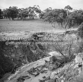
Negative - Photograph, J.A. McDonald, Dixons Creek, Sep. 1955
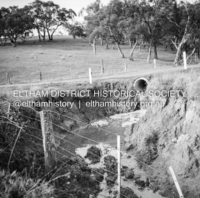
Record of various Shire of Eltham infrastructure works undertaken during the period of 1952-1962 involving bridge and road reconstruction projects, sometimes with Eltham Shire Council Project Reference numbers quoted. It was during this period that a number of significant improvements were made to roads and new bridges constructed within the shire that remain in place as of present day (2022). In many situations, the photos provide a tangible visible record of infrastructure that existed throughout the early days of the Shire. The album was put together by or under the direction of the Shire Engineer, J.A. McDonald.1955-09, dixons creek bridge, dixon's creek road, flood damage, floods, floodwater, infrastructure, shire of eltham -
 Eltham District Historical Society Inc
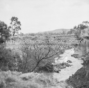
Negative - Photograph, J.A. McDonald, Dixons Creek, Sep. 1955
Record of various Shire of Eltham infrastructure works undertaken during the period of 1952-1962 involving bridge and road reconstruction projects, sometimes with Eltham Shire Council Project Reference numbers quoted. It was during this period that a number of significant improvements were made to roads and new bridges constructed within the shire that remain in place as of present day (2022). In many situations, the photos provide a tangible visible record of infrastructure that existed throughout the early days of the Shire. The album was put together by or under the direction of the Shire Engineer, J.A. McDonald.1955-09, dixons creek bridge, dixon's creek road, flood damage, floods, floodwater, infrastructure, shire of eltham -
 Eltham District Historical Society Inc
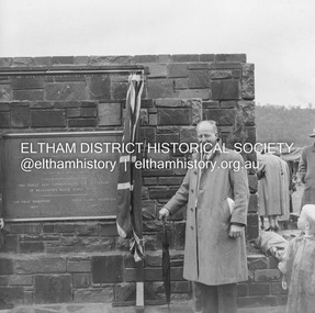
Negative - Photograph, J.A. McDonald, Upper Yarra Dam, 26 Nov. 1957
Sir Dallas Brooks following the formal opening of the Upper Yarra Reservoir, 26 November 1957 Upper Yarra Reservoir Opened by His Excellency The Governor of Victoria General Sir Dallas Brooks K.C.B.., K.C.M.G., K.C.V.O., D.S.O., K.St.J. On 26th November, 1957 This tablet also commemortyaes the centenary Of Melbourne's water supply system Yan Yean Reservoir 1857 Upper Yarra Reservoir 1957Record of various Shire of Eltham infrastructure works undertaken during the period of 1952-1962 involving bridge and road reconstruction projects, sometimes with Eltham Shire Council Project Reference numbers quoted. It was during this period that a number of significant improvements were made to roads and new bridges constructed within the shire that remain in place as of present day (2022). In many situations, the photos provide a tangible visible record of infrastructure that existed throughout the early days of the Shire. The album was put together by or under the direction of the Shire Engineer, J.A. McDonald.infrastructure, shire of eltham, 1957-11-26, opening ceremony, plaques, sir dallas brooks, upper yarra dam, upper yarra reservoir -
 Eltham District Historical Society Inc
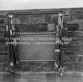
Negative - Photograph, J.A. McDonald, Upper Yarra Dam, 26 Nov. 1957
Upper Yarra Reservoir Opened by His Excellency The Governor of Victoria General Sir Dallas Brooks K.C.B.., K.C.M.G., K.C.V.O., D.S.O., K.St.J. On 26th November, 1957 This tablet also commemortyaes the centenary Of Melbourne's water supply system Yan Yean Reservoir 1857 Upper Yarra Reservoir 1957Record of various Shire of Eltham infrastructure works undertaken during the period of 1952-1962 involving bridge and road reconstruction projects, sometimes with Eltham Shire Council Project Reference numbers quoted. It was during this period that a number of significant improvements were made to roads and new bridges constructed within the shire that remain in place as of present day (2022). In many situations, the photos provide a tangible visible record of infrastructure that existed throughout the early days of the Shire. The album was put together by or under the direction of the Shire Engineer, J.A. McDonald.infrastructure, shire of eltham, 1957-11-26, opening ceremony, plaques, sir dallas brooks, upper yarra dam, upper yarra reservoir -
 Eltham District Historical Society Inc
Negative - Photograph, J.A. McDonald, Upper Yarra Dam, 26 Nov. 1957
Upper Yarra Reservoir Opened by His Excellency The Governor of Victoria General Sir Dallas Brooks K.C.B.., K.C.M.G., K.C.V.O., D.S.O., K.St.J. On 26th November, 1957 This tablet also commemortyaes the centenary Of Melbourne's water supply system Yan Yean Reservoir 1857 Upper Yarra Reservoir 1957Record of various Shire of Eltham infrastructure works undertaken during the period of 1952-1962 involving bridge and road reconstruction projects, sometimes with Eltham Shire Council Project Reference numbers quoted. It was during this period that a number of significant improvements were made to roads and new bridges constructed within the shire that remain in place as of present day (2022). In many situations, the photos provide a tangible visible record of infrastructure that existed throughout the early days of the Shire. The album was put together by or under the direction of the Shire Engineer, J.A. McDonald.infrastructure, shire of eltham, 1957-11-26, opening ceremony, plaques, upper yarra dam, upper yarra reservoir -
 Eltham District Historical Society Inc
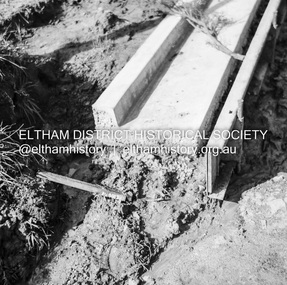
Negative - Photograph, J.A. McDonald, Eltham-Diamond Creek Road, May 1958
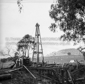
Wing pier Eltham abutment Bridge construction Eltham-Diamond Creek road over the Diamond Creek (Wattletree Road), Eltham, May 1958Record of various Shire of Eltham infrastructure works undertaken during the period of 1952-1962 involving bridge and road reconstruction projects, sometimes with Eltham Shire Council Project Reference numbers quoted. It was during this period that a number of significant improvements were made to roads and new bridges constructed within the shire that remain in place as of present day (2022). In many situations, the photos provide a tangible visible record of infrastructure that existed throughout the early days of the Shire. The album was put together by or under the direction of the Shire Engineer, J.A. McDonald.infrastructure, shire of eltham, 1958-05, bridge construction, wattletree road bridge -
 Eltham District Historical Society Inc
Negative - Photograph, J.A. McDonald, Eltham-Diamond Creek Road, May 1958
Bridge over Diamond Creek Pile driving Diamond Creek pier Bridge construction Eltham-Diamond Creek road over the Diamond Creek (Wattletree Road), Eltham, May 1958Record of various Shire of Eltham infrastructure works undertaken during the period of 1952-1962 involving bridge and road reconstruction projects, sometimes with Eltham Shire Council Project Reference numbers quoted. It was during this period that a number of significant improvements were made to roads and new bridges constructed within the shire that remain in place as of present day (2022). In many situations, the photos provide a tangible visible record of infrastructure that existed throughout the early days of the Shire. The album was put together by or under the direction of the Shire Engineer, J.A. McDonald.infrastructure, shire of eltham, 1958-05, bridge construction, wattletree road bridge -
 Eltham District Historical Society Inc
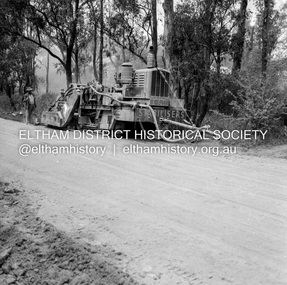
Negative - Photograph, J.A. McDonald, Eltham, Mount Pleasant Road, c.May 1958
Stabilising just below Metery RoadRecord of various Shire of Eltham infrastructure works undertaken during the period of 1952-1962 involving bridge and road reconstruction projects, sometimes with Eltham Shire Council Project Reference numbers quoted. It was during this period that a number of significant improvements were made to roads and new bridges constructed within the shire that remain in place as of present day (2022). In many situations, the photos provide a tangible visible record of infrastructure that existed throughout the early days of the Shire. The album was put together by or under the direction of the Shire Engineer, J.A. McDonald.infrastructure, shire of eltham, 1958-05, footpaths and gutters, mount pleasant road, road construction