Showing 6789 items matching "river"
-
 Eltham District Historical Society Inc
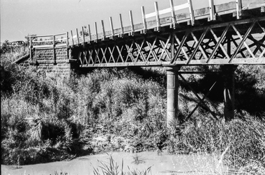
Photograph - Black and White Print, Railway Bridge across Plenty River near Railway Road, Briar Hill, Vic, c. August 1977
Para Road bridge across Plenty River can be seen behind railway bridge.Black and white photographinfrastructure, bridge, greensborough, para road bridge, railway road bridge, shire of eltham infrastructure -
 Eltham District Historical Society Inc
Photograph - Colour Print, Railway Bridge across Plenty River near Railway Road, Briar Hill, Vic, c. August 1977
Para Road bridge across Plenty River can be seen behind railway bridge.Colour photographinfrastructure, bridge, greensborough, para road bridge, railway road bridge, shire of eltham infrastructure -
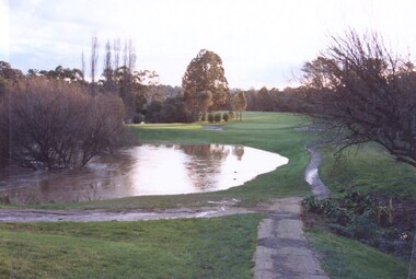 Heidelberg Golf Club
Photograph, Plenty River flooding across 2nd fairway, July 1997, July 1997
Plenty River flooding across 2nd fairway, July 1997, Heidelberg Golf ClubColour photograph of a golf courseheidelberg golf club, 2nd fairway -
 Greensborough Historical Society
Photograph - Digital image, Frank Robinson, Greensborough near Plenty River bridge and football ground, 1954_
Greensborough near Plenty River bridge and football ground. The Blackjack property, house and acres of fruit orchards ran down to the Plenty River off Hume Street Greensborough and was the home of the Robinson family to late 1956. The photographs were taken as slides by Frank Robinson and digitised by his son James in 2015.Digital copy of colour photograph.robinson family, plenty river, blackjack -
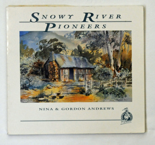 Orbost & District Historical Society
book, Andrews, Gordon, Snowy River Pioneers, 1990
This book was produced by Gordon and Nina Andrews of Netherbyre in Orbost.This is a locally created book. It helps to tell the story of who the Snowy River pioneers and therefore how we came to settle here. It is a useful research tool and is significant to the history of the Orbost area.A 47pp soft covered book titled, Snowy River Pioneers, by Gordon and Nina Andrews, On the front cover is a coloured painting of a hut in bushland. It contains Charles West and other selected stories. The text is by Gordon Andrews. The artwork is by Nina Andrews and Vere Moon.Copyright 1990 Gordon & Nina Andrews Netherbyre, Orbost 3888snowy-river-pioneer stockmen -
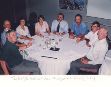 Lakes Entrance Historical Society
Photograph, Lakes Post Newspaper, Tambo Nicholson River Management Group East Gippsland Victoria, 1999
Colour photograph of members of Tambo Nicholson River Management Group seated at round table discussion Charles Hogan Alan Somerville Margaret Gardener Jeanette Severs Rex Candy Kevin Dean Robin Minter and Bill Wilson East Gippsland Victoriaenvironment, fish, waterways -
 Kew Historical Society Inc
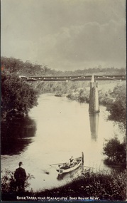
Postcard, River Yarra near Macauleys' Boathouse Kew, c.1910
The Pipe Bridge was constructed to bring fresh water from Fairfield to Kew. This bridge was destroyed in the 1934 Flood and later reconstructed.Early sepia real photo postcard of the first Pipe Bridge bringing water from the Yan Yean Reservoir to Kew. The site is upriver of the original Macauley's boathouse. Obverse: "River Yarra near Macauleys' Boat House Kew". Reverse: "(Pipe Water Line) / Kew to Fairfield above boat house / Pipe Bridge / Received from L. Bennett 1980".bridges - kew (vic.), bridges - yarra river -- kew (vic.), pipe bridge -
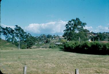
 Greensborough Historical Society
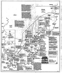
Map, Heidelberg: Historic River Landscape Assessment. Historical maps. Map D 1864 -1901 "Sleepy Hollow" and "Sleeping beauty", 1985c
Geographical area of c. 35 sq. kilometres marked with physical features such as major roads, rivers, vegetation and properties, with locations and notes on the increasing number of farms, orchards and vineyards that had been developed in addition to pastoral runs. Bounded by Shire of Diamond Valley to the North, Darebin Creek to the West, and Plenty River to the East.Black and white sketch on white paper. Second copy 600 x 430 cm printed in black on semi-opaque paperheidelberg, heidelberg - maps -
 Greensborough Historical Society
Photograph - Digital image, Frank Robinson, Looking across the Plenty River from Pope's paddock to Blackjack, 1954_
Looking across the Plenty River from Pope's paddock to Blackjack. The Blackjack property, house and acres of fruit orchards ran down to the Plenty River off Hume Street Greensborough and was the home of the Robinson family to late 1956. The photographs were taken as slides by Frank Robinson and digitised by his son James in 2015.Digital copy of colour photograph.blackjack, popes paddock, robinson family -
 Greensborough Historical Society
Slide - Photograph, John Ramsdale, Ford over Plenty River to Partington's Flat: Slide 72, 1990s
Photograph shows road or path over culvert. This is the ford over Plenty River to Partington's FlatPart of the John Ramsdale collection of slides and audio visual material.Colour photograph scanned from slide.No caption. Printed maker's mark on slide "Kodak Kodachrome Slide"ford over plenty river, plenty river, partington's flat -
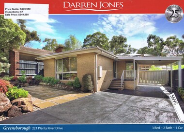 Greensborough Historical Society
Advertising Leaflet, Darren Jones, 221 Plenty River Drive Greensborough, 13/05/2017
221 Plenty River Drive Greensborough. Three bedroom house, sold for $649,950 in July 2017. Real estate advertising leaflet, 1 sheet, printed in colour both sides. plenty river drive greensborough -
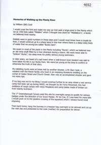 Greensborough Historical Society
Document, Bill Cecil, Memories of walking up the Plenty River, by William (Bill) Cecil, 1950o
Bill Cecil remembers activities from his youth including rabbit hunting on the Plenty River1 page, typescriptplenty river, bill cecil -
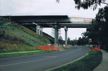 Greensborough Historical Society
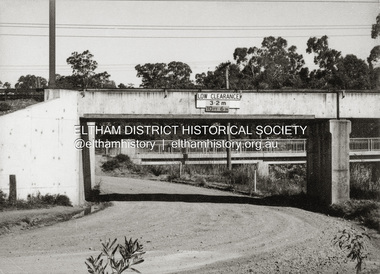
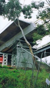
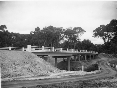
Photograph - Digital image, Frank Solomon, Plenty River Drive Bridge Roadworks 1, 1995c
These photos show the duplication of the bridge over Plenty River Drive on the Greensborough Bypass, circa 1995.Digital copy of colour photographplenty river drive, greensborough bypass -
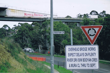 Greensborough Historical Society
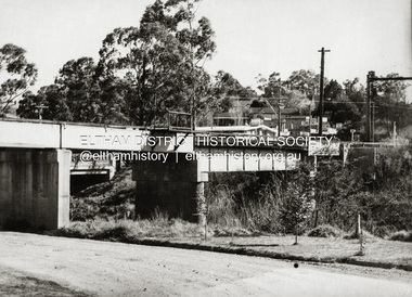
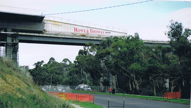
Photograph - Digital image, Frank Solomon, Plenty River Drive roadworks 2, 2005c
These photos show the duplication of the bridge over Plenty River Drive on the Greensborough Bypass, circa 2005.Digital copy of colour photographplenty river drive, greensborough bypass -
 Greensborough Historical Society
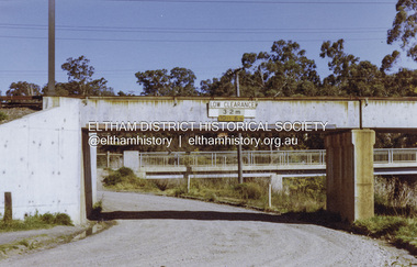
Photograph - Digital image, Frank Solomon, Plenty River Drive Bridge Roadworks 3, 2005c
These photos show the duplication of the bridge over Plenty River Drive on the Greensborough Bypass, circa 2005.Digital copy of colour photographplenty river drive, greensborough bypass -
 Greensborough Historical Society
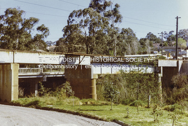
Photograph - Digital image, Frank Solomon, Plenty River Drive Bridge Roadworks 4, 2005c
These photos show the duplication of the bridge over Plenty River Drive on the Greensborough Bypass, circa 2005.Digital copy of colour photographplenty river drive, greensborough bypass -
 Stawell Historical Society Inc
Photograph, Campbell’s Bridge over the Wimmera River 1961
Newly built Campbell’s Bridge over the Wimmera River. Built by Redman Bros. Opened in 1961.stawell shire -
 Greensborough Historical Society
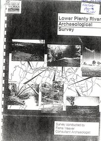
Report, Lower Plenty River Archaeological Survey; Fiona Weaver, 1989_
Archaeological survey of the Lower Plenty River undertaken in 1989-1990 by Fiona Weaver for the Board of Works. Indigenous heritage sites along the Plenty River are examined and recommendations made for the preservation and to lessen the impact of development on these sites.Printed on white A4 paper. Approx 92 pages (not numbered). Illus., maps. 2 copies.plenty river, board of works, aboriginal heritage sites, fiona weaver -
 Greensborough Historical Society
Photograph - Digital image, Frank Robinson, Looking north over the football ground with bridge over Plenty River, 1954_
Looking north over the football ground with bridge over Plenty River. The Blackjack property, house and acres of fruit orchards ran down to the Plenty River off Hume Street Greensborough and was the home of the Robinson family to late 1956. The photographs were taken as slides by Frank Robinson and digitised by his son James in 2015.Digital copy of colour photgraph.robinson family, blackjack, plenty river -
 Kew Historical Society Inc
Photograph - Yarra River in flood at the Willsmere Park, 1993
Willsmere Park is bounded by the the Yarra River, Green Acres Golf Club, Willow Grove and the Eastern Freeway. The land on which the park is now situated was bought by Thomas Wills at the Crown Land Sales of 1846 (Section 56). From the 1840s to the 1940s it was intensively farmed. The park is dominated by very large playing fields, while planting to the southern boundary was undertaken when the Eastern Freeway was built. It is only along the banks of the Yarra that there is any remnant native vegetation. Willsmere Park is of significance as an area of open land that remains from the flood plain that once dominated northern Kew. (Source: Kew Conservation Study, 1988)Original colour small format polaroid photograph of the Yarra River in flood at the Willsmere Park, taken on 16 September 1993."Yarra River at Willsmere Park Flooding 16.9.93"willsmere park, yarra river -- floods -- kew (vic.) -
 Greensborough Historical Society
Photograph - Digital image, Marilyn Smith et al, Janefield Precinct: View of river bend, 27/11/2014
Janefield Precinct: View of river bend. The remains of this site are between Greensborough and Janefield. A RAAF Hygiene Training Camp was located on the Plenty River, just south of the Janefield community. It was in use from 1944 to 1946. The Camp was constructed from salvaged materials. Instruction included building and maintenance of grease traps, latrines, elementary plumbing and carpentry.Early remains of a WW2 training camp Digital colour photograph.janefield -
 Orbost & District Historical Society
black and white photograph, Snowy River Mail, October 1987
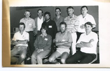
This a photograph of the Gippsland representatives at the C.A.T.S. conference. This photograph was taken at the Curriculum and Technology in Schools workshop held in Bendigo, Victoria in October 1987. Eighty rural primary schools were involved including many from East Gippsland. From the Snowy River Mail; " A large number of technologies was......demonstrated at the conference. Participants were given hands on experience with audio and computer conferencing, CD Rom. an Invicon booth ( individual video console (INVICON) enables any teacher to produce short, relevant teaching videos for individual pupils without assistance), packet radio, videodisk, robotics and many more...." In the back row are: Al Balfour (Bairnsdale Min of E); Graeme Rodier (OHS); Roger Nink (Swifts Creek); John Hillier (Mallacoota); Barry Lay ( Bairnsdale HS); Ross Burn ( Bairnsdale HS), In the front row are: Jeff Wilson (Mallacoota); Bea Lay (Bairnsdale HS); Rick Box ( Swifts Creek) and Brian Pomeroy (AVRB Bairnsdalel). Al Balfour was a noted educator, local identity and one of country Victoria's strongest advocates.This is a pictorial record associated with education in East Gippsland.A black / white photograph of a group of people. The back row is standing and the front is sitting on chairs.education-east-gippsland technology -
 Port Melbourne Historical & Preservation Society
Book, Meyer Eidelson, "Yalukit Willam - The River People of Port Phillip", Feb 2015
Written as part of the City's reconciliation program and with the assistance of Carolyn Briggs over a two year program."Yalukit Willam - The River People of Port Phillip" by Meyer Eidelson: illustrated soft cover, 99 pages plus fold out map at back cover is WFE Liardet watercolour of Emerald Hill corroboree and history of Koori activity pre and during European occupationSigned IFC by author, and Carolyn Briggs, Boon Wurrung Foundation, "yours with respect"australian aborigines, parks and gardens, natural environment, meyer eidelson, carolyn briggs, derrimut, yalukit willam clan, boon wurrung, kulin nation, bunjil, george robinson, ben bow, louisa briggs, wilbraham frederick evelyn liardet, wfe liardet, josephine liardet, emerald hill, william buckley, kurburu (the bear) -
 Ballaarat Mechanics' Institute (BMI Ballarat)
Film - Photograph by Herb Richmond. ca 1971, Pitfield Bridge- Over the Woady Yalloak River, South of Cape Clear. This bridge has been replaced by a modern bridge
Ballarat History35mm B&W Kodak Plus X Pan Film.ballarat, ballaraat, pitfield, bridge, woady, yalloak, river -
 Benalla Art Gallery
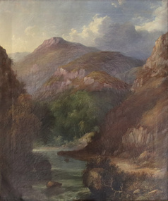
Painting, J. H. CARSE, Mountain River, 1866
Born: Edinburgh, Scotland c.1818; Arrived: Melbourne, Victoria, Australia c.1867; Died: Sydney, New South Wales, Australia 1900VictorianGift of Mrs E.E. Ledger, 1985Rural landscape with dirt track, narrow stream, trees and steep mountains. Gold brushed and painted timber frame.Recto: Signed and dated “J H Carse / 1866” in brown oil, l.r.c of composition; Not titled painting, landscape, mountains, river, clouds, sky, trees -
 Greensborough Historical Society
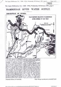
Article - Newspaper Clipping (copy), The Argus, Maroondah River water supply 1891, 18/02/1891
An historical account of the development of Melbourne's Maroondah River water supply, including a description of works undertaken in the 1890s.3 p., photocopy of article, downloaded from Trove. Includes transcript in Word document.melbourne water, mmbw, maroondah aqueduct, yan yean reservoir, greensborough, plenty river -
 Greensborough Historical Society
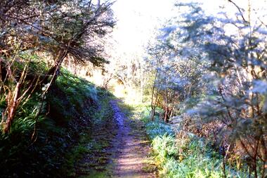
Slide - Photograph, John Ramsdale, Along Plenty River near Para Road: Slide 86, 1990s
Photograph shows a track through bushland, along the Plenty River near Para Road, possibly Montmorency.Part of the John Ramsdale collection of slides and audio visual material.Colour photograph scanned from slide.No maker's marks. No caption on slide.plenty river, para road montmorency, bushland -
 Greensborough Historical Society
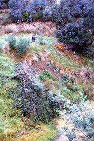
Slide - Photograph, John Ramsdale, Slumping erosion along the Plenty River: Slide 110, 1990s
Photograph shows a man standing on an embankment which is being eroded. This is slumping erosion along the Plenty River.Part of the John Ramsdale collection of slides and audio visual material.Colour photograph scanned from slide.No maker's marks. Caption on slide "Plenty"plenty river, erosion