Showing 1529 items
matching streetscape
-
 Stawell Historical Society Inc
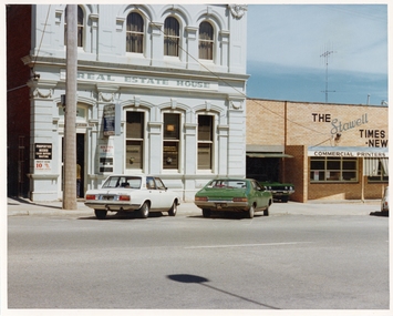
Photograph, Pleasant Creek Special School, Stawell Estate Agent - Jim Rathgeber, Stawell Times News Nov 1975, Nov 1975
Photographs taken by teacher at Pleasant Creek Training Centre to help train students in living skills and becoming familiar with what shops sold. Part of socializing students for leaving the training centre.Main Street Stawell. Showing shops and businesses in Main Street. education, shops, main street, streetscape -
 Stawell Historical Society Inc
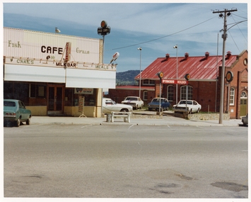
Photograph, Pleasant Creek Special School, Sheffield's Café & Milk Bar, McCracken's Holden Used Car Yard, Salvation Army Citadel Nov 1975, Nov 1975
Photographs taken by teacher at Pleasant Creek Training Centre to help train students in living skills and becoming familiar with what shops sold. Part of socializing students for leaving the training centre.Main Street Stawell. Showing shops and businesses in Main Street. education, shops, main street, streetscape -
 Stawell Historical Society Inc
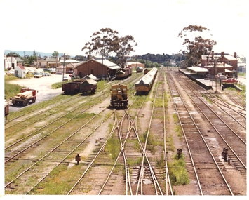
Photograph, Pleasant Creek Special School, Stawell Railway Station, Goods Shed and Railway Station Nov 1975, Nov 1975
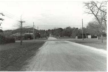
Photographs taken by teacher at Pleasant Creek Training Centre to help train students in living skills and becoming familiar with what shops sold. Part of socializing students for leaving the training centre.Napier Street Stawell education, railways, transport, streetscape -
 Ballarat Heritage Services
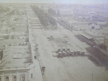
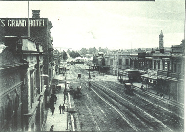
Photograph - black and white, Sturt Street, Ballarat 1870
sturt street, ballarat, streetscape, architecture -
 Ballarat Heritage Services
Photograph - Colour, Market Street, Kyneton, 2016, 13/05/2016
Photograph of every house in Market Street, Kynetonmarket street kyneton, kyneton, architecture, streetscape -
 City of Ballarat Libraries
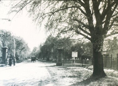
Photograph - Card Box Photographs, North Gates, Ballarat Botanic Gardens circa 1915
The Ballarat Botanic Gardens were once formally fenced and the gates closed at night. The gate posts still remain. The sign in photo 585 reads 'Motorists Drive Slowly'.ballarat botanic gardens, north gates, garden, streetscape -
 City of Ballarat Libraries
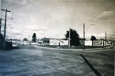
Photograph - Card Box Photographs, South West Corner of Barkly Street and Main Road, Ballarat 1969
main road, barkly street, streetscape, advertising -
 Ballarat Heritage Services
Photograph - Digital photograph, Lisa Gervasoni, Housing in Cotham Ward, Kew, 2017
Housing units in Cotham Road, Kewkew, housing, streetscape, archiecture -
 Ballarat Heritage Services
Photograph - Digital photograph, Lisa Gervasoni, Housing in Cotham Ward, Kew, Victoria, 2017
Double storey building in Kew, a suburb of Melbournekew, housing, streetscape, architecture -
 Ballarat Heritage Services
Photograph - Image, Lydiard Street Looking North, c1895, c1895
Black and white image of Lydiard Street looking North. A steam train crossed the railway line. lydiard street ballarat, steam train, streetscape, architecture -
 Buninyong & District Historical Society
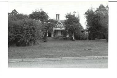
Photograph - B/W photograph, Clifton Villa, Buninyong, 1994
Early house reflecting a degree of wealth, built for Buninyong Chemist around 1859historical and architectural elementsB/W photo of Clifton Villa, family dwelling built c 1859 cnr Eyre and Winter Streets Buninyong, lacework on barge boards and veranda, special feature chimneys. House built for Mr Newman,, chemist in Buninyong.clifton villa, house, garden, streetscape -
 Buninyong & District Historical Society
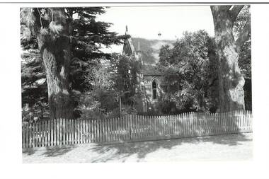
Photograph - B/W photograph, Former Wesleyan Church, Buninyong, 4 Apr 1994
Former Wesleyan Church photographed 1994 after conversion to residenceClassic C19th brick churchNorth side of former Wesleyan Church, Warrenheip St Sth. Partly hidden by trees, white picket fence.wesleyan church, streetscape, trees, buninyong -
 Buninyong & District Historical Society
Photograph - Original B/W Photograph, Scott St looking east from intersection with Warrenheip St, 19th July 1993
Scott St was originally an alternative cart track down from Mt. Buninyong.This streetscape is of historic and social significance.Original B/W photo of Scott St looking east from its intersection with Warrenheip St.scott st, warrenheip st, streetscape, mount buninyong -
 Federation University Art Collection
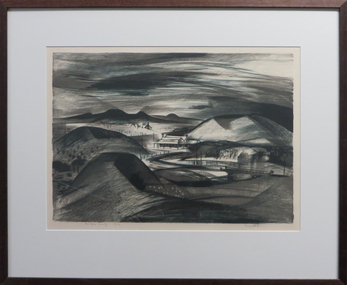
Work on paper - Artwork - Printmaking, Jack, Kenneth, "The Gold Country" by Kenneth Jack, 1960
Framed limited edition two plate lithograph. Donated through the Australian Gifts Programme by Katherine Littlewood.Edition 16/30 kenneth jack, printmaking, landscape, streetscape -
 Canterbury History Group
Photograph - Streetscape of shops underneath the Maling Road Theatre, Jan Pigot, 27/03/1993 12:00:00 AM
Coloured photograph of of a view of shops underneath the Maling Road Theatrecanterbury, maling road, shops, streetscape -
 Bendigo Trades Hall Council & Literary Institute Inc.
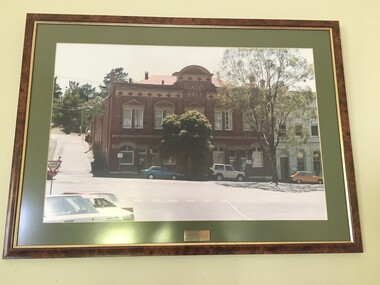
Photograph - Bendigo Trades Hall Council Building
Photo of the Bendigo Trades Hall in the year 1990.Presented to Bendigo THC With Thanks Arnold, Thomas & Becker 13-02-90architecture, red brick, cars, streetscape -
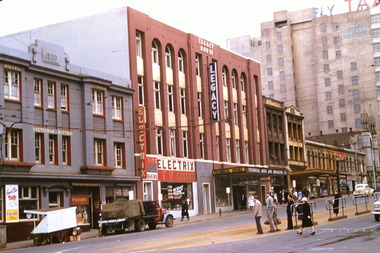
 Melbourne Legacy
Photograph, Legacy House, 1997
A photo of Legacy House from 1997. Junior Legacy Melbourne purchased 289-299 Swanston Street Melbourne (previously called Red Cross House) in 1956 from the Commonwealth Government with money gifted to Legacy in memory of David H Dureau. The donation was initially used to purchase a different building at 342 Swanston St, which was sold in 1954, and 289 Swanston St was purchased. Melbourne Legacy is still using three floors of the building, with tenants on the ground floor. Plus two photos from earlier time that have been digitised from slides. The brown photo would have been from late 1950s and then the green is after it was repainted in 1961 (according to the slide mount) An article mentions the purchase price was undisclosed. It says the purchase was possible due to a generous gift of money from overseas in 1944. The building would be called the David H Dureau Memorial Building at the request of the donors. A record of what the Legacy House building looked like when it was acquired by Melbourne Legacy. Black and white photo of Legacy House from 1997.dureau house, properties, streetscape, swanston st -
 Melbourne Legacy
Slide, Legacy House, 1957
A slide image of Legacy House from 1957. Junior Legacy Melbourne purchased 289-299 Swanston Street Melbourne (previously called Red Cross House) in 1956 from the Commonwealth Government with money gifted to Legacy in memory of David H Dureau. The donation was initially used to purchase a different building at 342 Swanston St, which was sold in 1954, and 289 Swanston St was purchased. Melbourne Legacy is still using three floors of the building, with tenants on the ground floor.A record of what the Legacy House building looked like when just after it was acquired by Melbourne Legacy.Colour slide x 2 of Legacy House from 1957.Both slides are marked as 'Legacy House', one is numbered '9' and the other '10' by the manufacturer.dureau house, properties, streetscape, swanston st -
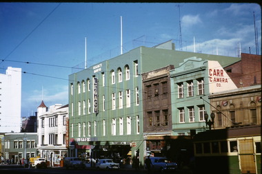 Melbourne Legacy
Slide, Legacy House, 1961
A slide image of Legacy House from 1961. after it had been repainted. Junior Legacy Melbourne purchased 289-299 Swanston Street Melbourne (previously called Red Cross House) in 1956 from the Commonwealth Government with money gifted to Legacy in memory of David H Dureau. The donation was initially used to purchase a different building at 342 Swanston St, which was sold in 1954, and 289-299 Swanston St was purchased. Melbourne Legacy is still using three floors of the building, with tenants on the ground floor.A record of what the Legacy House building looked like when just after it was acquired by Melbourne Legacy.Colour slide of Legacy House from 1961.Slide mount has 'Legacy House after repainting 19-6-61' handwritten in blue pen.dureau house, properties, streetscape, swanston st -
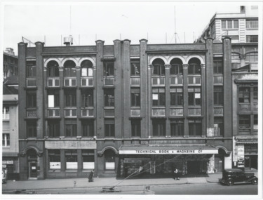 Melbourne Legacy
Photograph, Legacy House, 1956
A photo of Legacy House in the 1950s. Junior Legacy Melbourne purchased 289-299 Swanston Street Melbourne (previously called Red Cross House) in 1956 from the Commonwealth Government with money gifted to Legacy in memory of David H Dureau. The donation was initially used to purchase a different building at 342 Swanston St, which was sold in 1954, and 289 Swanston St was purchased. Melbourne Legacy is still using three floors of the building, with tenants on the ground floor. It was used in a newspaper article about the acquisition of the building for Legacy. It mentions the purchase price was undisclosed. It says the purchase was possible due to a generous gift of money from overseas in 1944. The building would be called the David H Dureau Memorial Building at the request of the donor. The article has a photo of Governor Sir Dallas Brooks and the Legacy President Bob Gaylard. The notation LH5 in red pen implies it was part of an early archive project by Frank Doolan.A record of what the Legacy House building looked like when it was acquired by Melbourne Legacy.Black and white photo of Legacy House around the time when it was acquired in 1956 and newspaper reprint of an article about the acquisition marked LH5.Stamped on reverse 'Please Acknowledge Australian News and Information Bureau' in purple ink. Newpaper reprint has LH5 in red pen on top right corner, part of an archive project.dureau house, properties, swanston st, streetscape -
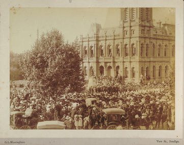 Bendigo Historical Society Inc.
Photograph - BENDIGO BOER WAR MEMORIAL (UNVEILING OF), 11/11/1904
Sepia photograph mounted on fawn board. Bendigo Post Office, Boer War Memorial, crowd of people, horse drawn vehicles. Inscriptions: on front - printed 'GL Massingham, View Street Bendigo', on back - circular stamp 'Royal Historical Society of Victoria, Bendigo Branch'. History: James Lerk 'Unveiling of the Boer War Memorial' by J Walker, Sculpture at the corner Pall Mall and Williamson Street. Helen Mainka August 2001 'Unveiled by Brig. Gen. Gordon 11/11/1904GL Massingham, View St, Bendigoplace, streetscape, pall mall, prev. acc no. gp51 -
 Ballarat Heritage Services
Photograph - Daylesford, Murray Views, Panorama of Daylesford Looking Towards Wombat Hill
Daylesford is a tourist town in central Victoria known for its mineral water springs.Houses in Daylesford looking towards Wombat Hill.daylesford, murray views, wombat hill, streetscape -
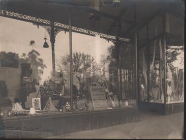 Bendigo Historical Society Inc.
Photograph - HANRO COLLECTION: PHOTO OF SHOP FRONT DISPLAY WINDOW
See Item 11000.189Photo of shop Front Display Window: A black and white photo of large open windows with a central door. In the window on the left side wall is a display sign with *Hanro* A stand along display sign with a golfer swinging a club and two golf balls near by. Casual wear and shirts are displayed around with spools of thread. A Chair with cardigans is also displayed. Some plants are in the window and in the front is a sign with *Benknit Sports Wear for men and women, Product of Hanro (Aust) Bendigo Knitting Mills Pty Ltd. In the right window is a display of lingerie with yards of material draped through out the window. At the bottom of the photo is the imprint of the photographer *Bartlett Bros, Bendigo. A small tear at the top middle. The reflections in the windows is of the veranda with a lamp hanging from underneath and trees. On the back is the circular *Royal Historical Society of Victoria Bendigo Branch in blue ink. At the right top side in black ink in *MP368*. Box 116ABartlett Bros, Bendigo.photograph, streetscape, window display, hanro. -
 Glenelg Shire Council Cultural Collection
Print, Arwa Pishori, Timeless Town, 2017
Image showing the corner of Bentinck Street and Gawler Street in Portland. There are two cars in the image - one going across the roundabout and one parked in front of Clock By the Bay. Across the road from Clock By the Bay is Macs Hotel. The image is sepia coloured with a slightly blue sky. It is landscape orientation.16/20 / 'Timeless Town' / Arwa Pishori / 2017portland, portland town, portland businesses, streetscape -
 Glenelg Shire Council Cultural Collection
Painting, Robert Miller et al, Old Church Portland, 1965
CEMA Art CollectionThe painting depicts a church in an otherwise empty landscape. Within the foreground is a sweeping corner of a dirt road. Along the edge of the road runs a simple fence. Behind the church is a bare yellow and brown hill which reaches into a dark sky. The work has a wooden, white painted frame with grey mount and white trimming and glass.Front: Robert T. Miller 75 (lower right, black signature) Back: ROBERT MILLER " OLD CHURCH PORTLAND" (1966) (lower right, typed) Watercolourportland, church, streetscape, religion -
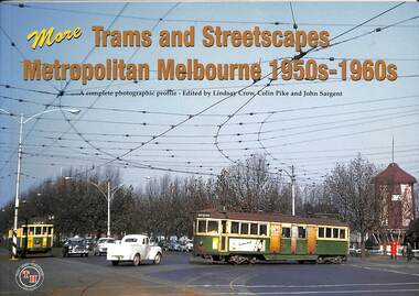 Melbourne Tram Museum
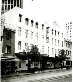
Book, Lindsay Crow et al, "More trams and streetscapes Metropolitan Melbourne 1950s - 1960s", Apr. 2002
Book - 48 pages+ card cover + jacket, perfect bound, landscape format, "More trams and streetscapes Metropolitan Melbourne 1950s - 1960s", edited by Lindsay Crow, Colin Pike and John Sargent, published April 2002, featuring photos by Keith Atkinson, Graham Evans, Ron Lennard, Don McLean, Eric Quinlan, Michael Schrader and Jim Seletto. See Reg Item 4289 for the first in the series published Dec 2000.trams, tramways, melbourne, work trams, mmtb -
Clunes Museum
Photograph - PHOTOGRAPHS
.1 The netball court in the photo was where "Collins Place", Fraser Street, Clunes is now located .3 the warehouse/Clunes Museum building at 36 Fraser Street, Clunes, was a former freezing worksPhotocopies of photographs .1 2 copies of girls playing netball .2 A streetscape of Fraser Street, Clunes .3 Del Mayberry (nee Campbell) and friend. The building that is now the warehouse/Clunes Museum is in the background of this photo, the building was a former freezing works .4 Jean Harling (nee Campbell) and male friend, outside The Club Hotel, Fraser Street, Clunes .5 Landscape of Clunes looking towards Station Flat Road. Port Phillip Mine is in the backgroundcampbell, netball, mayberry, harling -
 Federation University Historical Collection
Photograph - Photograph - black and white, Ballarat School of Mines, Lydiard Street, Ballarat, c1909, c1909
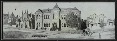
Ballarat School of Mines was established in 1870 making it Australia's first School of Mines. It is now Federation University Australia SMB Campus.Ballarat School of Mines from Lydiard Street. The former Wesley Church is on the left of the photo. Beside it is the New Classrooms (now Administration Building), and the former Ballarat Circuit Court which was demolished in 1912 and replaced the the Ballarat Technical Art School building. .1) Sepia print .2) Black and white print showing all the Lydiard Street streetscape with people in the doorway and a horse and buggy in the street. .3) Black and white copy .4) Line drawing taken from the photo.ballarat school of mines, lydiard street, ballarat, administration buildings, former circuit court, former wesley church, administration building, a building, former methodist church -
 Ballarat Tramway Museum
Photograph - Black & White Photograph/s, c1906
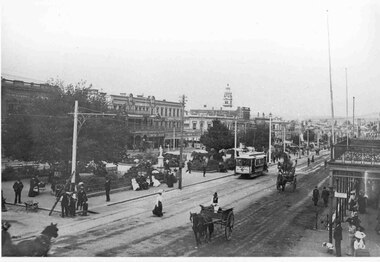
Yields information the operation of electric trams in Sturt St Ballarat, the streetscape and the how the street was used by other vehicles and pedestrians.Black and White photograph of the streetscape of Sturt St, Ballarat looking east from the corner of Dawson and Sturt Streets with many people, horse drawn carts and a tram. Note the horse drawn cart in the bottom left hand corner is travelling on the "wrong side" of the road. Also shows the condition of the road surface, many pedestrians, ladies, and stores and shops on the north side of Sturt St. C1906. The tram has a front advertisement for something being held on a Saturday the Post Office in the far background. tramways, trams, sturt st, dawson st, horse drawn vehicle -
 Melton City Libraries
Photograph, Edna Barrie, Unknown
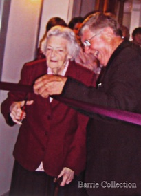
Over 20 years commencing in the 1970s, Edna undertook extensive photographing of the changing streetscape of Melton’s High Street. She anticipated the impact of change on the community during the time of Melton’s rapid transition from a small farming district to a large urban community and this led to her extensively document and photograph many of the structures and landscape features of the township that have since been lost. She also meticulously recorded much of the contemporary life of the town and has left a significant legacy of archival material. Edna Barrie cutting a ribbon to an opening of a eventlocal identities, pioneer families