Showing 26088 items
matching councils
-
 City of Kingston
Photograph - Digital image, Black and white, c. 1900
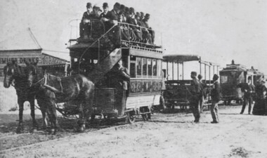
The availability of reliable regular and frequent public transport was very important to the land speculators of the 1880s. Charles H James, an early land speculator, had large holdings in the Shire of Moorabbin at Black Rock, Sandringham and Mentone. In 1884 he was advertising the auction of 109 blocks of land at ‘Picnic Point’ in the Brighton Southern Cross.[1] He provided free railway passes and conveyance to the grounds to prospective buyers. A proposal to extend the Brighton Railway to Sandringham and Black Rock seemed remote in 1884 so James acted to resolve the lack of public transport by forming his own tramway company. From the discussion between the Council and James it was agreed that the Council would apply for permission to construct a tramway on Beach Road. By February 8, 1889 the horse drawn trams were running from Cheltenham Station to Rickett’s Point and from Sandringham Station to ‘Blackrock Corner’. Although stricken with financial problems for its entire existence, Beaumaris Tramway Company continued until 1915.Black and white image of two horses. harnessed to a double decker tram, being pulled along the tram tracks laid in the street. There are men sitting on the top level of the tram, in the open air. Other trams are lined up behind this one, although with no people in them. The tram belongs to the Beaumaris Tramway Company. -
 Eltham District Historical Society Inc
Photograph - Colour Print, Alan Marshall's bungalow, 13 Park West Road, Eltham, 22 July 1993
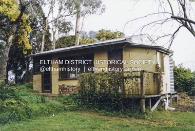
From 1955 Alan Marshall's home was a bungalow at the rear of his sister's house at Eltham. The first bungalow burnt down. Its replacement shown here still stands. In March 2020 the property was sold. It was last sold previously in November 1982. No mention was made in the advertising regarding the heritage protected bungalow in the rear yard and advertising material presented it as having future potential to develop STCA (Subject To Council Approval). Concerned local members of the community alerted to EDHS to the pending upcoming sale and Council was also alerted to the sale and the potential risk presented to the heritage protected bungalow. In 2021 an updated amendment, C133nill, was made to the Nillumbik Planning Scheme in response to a planning application to develop the property following its sale. The Minster of Planning approved and gazetted the Amendment. Gazettal occurred on 25th November 2021. A copy of the gazetted Amendment is available on website of the Department of Environment, Land, Water and Planning at www.planning.vic.gov.au/schemes-and-amendments/browse-amendments. It was last updated March 2022.Colour photo print 10 x 15 cm, originally stuck down on corflute for displayeltham, alan marshall, alan marshall bungalow, heritage assessment, heritage protection overlay, houses, nillumbik shire council, park west road, heritage overlay ho147 -
 Orbost & District Historical Society
cuff links, 1992
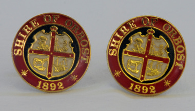
This pair of cuff links was produced in 1992 as a memento/souvenir to commemorate the centenary of the formation of the Shire of Orbost - 1892-1992. Orbost was at first included in the Bairnsdale Shire from 1882 and was later part of the Tambo Shire. Because of travelling distances the Croajingalong Shire was created in 1892 (name changed to Orbost Shire 17.2.1893 with James Cameron as the first Shire President. In 1994 it amalgamated to become part of East Gippsland Shire Council.A pair of gold-plated and enamel cuff links embossed with the Shire of Orbost Coat of Arms and the year of inauguration.Shire of August 1892cuff-links souvenir memento orbost-shire-council -
 Kiewa Valley Historical Society
Report - Alpine Area Proposed Recommendations, Land Conservation Council, Victoria Melbourne, April 1978, April 1978
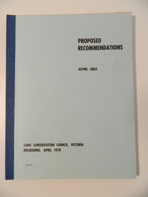
The Land Conservation Council was established by the Land Conservation Act 1970. It makes recommendations to the Minister for Conservation with respect to the use of public land. Notices showing the boundary of the study area ... published in the Victorian Government Gazette Sept. 1973. A descriptive report was published in July 1977. Submissions (1538) on the future use of public land were received & included those representing a wide cross-section of the community. These were considered in the final report.Of interest for research on the changing ideas regarding the use of public land and the environment.Blue book bound by dark blue cloth tape. It has 92 pages with maps at the end and an empty folder inside the back cover.alpine area, land conservation council, alpine study area report -
 Warrnambool and District Historical Society Inc.
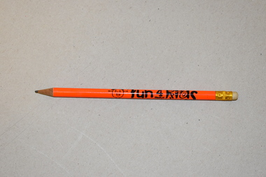
Pencil, Fun 4 Kids Festival, Early 21st century
This pencil is a souvenir of the Fun 4 Kids Festival, a children’s festival run by Warrnambool City Council from 1999 to 2018. It was held during a week in winter on the Civic Green at the corner of Timor and Liebig Streets with the site including temporary buildings as well as the adjoining permanent buildings. The festival was highly regarded and won the 2015 Gold Australian Tourism Award. Declining numbers and increasing costs led to its demise in 2018.This pencil is a memento of Fun 4 Kids, a children’s festival run by the Warrnambool City Council. Existing for 19 years, it was one of the longest surviving children’s festivals in Australia.This is a round wooden pencil containing a thin sliver of graphite. The pencil has a metal band and a rubber at one end and is sharpened at the other end. The pencil has an orange covering, black lettering and an image of a child and a sun.Fun 4 Kids Festivalfun 4 kids warrnambool -
 Port of Echuca
Photograph - Black and white photograph, Late 1970s
Relates to a series of 5 photos:P000094-P000098 of the front of the Bridge Hotel on the corner of Murray esplanade and Hopwood gardens. These photos, taken about 1976, were before the Port Restoration Scheme renovated the hotel. The Bridge Hotel was built by Henry Hopwood in 1858. This and the Bond Store were Echuca's first 2 brick buildings. Named from Hopwood's nearby pontoon bridge. The building was bought be The Council in 1970. Restored and reopened in 1975.The Bridge Hotel is an important part of Echuca's settlement and development. It was originally built by Henry Hopwood, the European founder of Echuca, in 1859. Hopwood built the hotel to provide accommodation to people using his punts across the Campaspe and Murray rivers that area central to the landscape of the Port. The hotel was situated on the land between both rivers and punts and provided for a variety of levels of accommodation from grand rooms to very basic rooms. At the time of the photos the hotel was 120 years old and became an important part of the Port of Echuca tourism. Black and white photograph of the Bridge Hotel , showing western wing before restoration.Stamped on the reverse "Gazemore Studio, D. G. Gay, 18 Frances Street Echuca 3625.bridge hotel, echcua, port restoration scheme, bridge hotel restoration, echuca -
 Eltham District Historical Society Inc
Document - Folder, Naughton, Tracey
Tracey Naughton was Eltham's Community Arts Officer. Contents Newspaper article: "Bringing the art community together", Diamond Valley News, 9 September 1986. Report of luncheon organised by Shire of Eltham's Community Services, speaker Tracey Naughton. Newspaper article: "Councils agree on merger decision", Diamond Valley News, 9 September 1986. Report on State government decision not to force merger of Eltham and Diamond Valley Shires.Newspaper clippings, A4 photocopies, etctracey naughton, community arts officer eltham, bob manuel, eltham shire, diamond valley shire, bob picone -
 Eltham District Historical Society Inc
Photograph, His Excellency Major General Sir Rohan Delacombe with Lady members of the Shire of Eltham Elderly Citizens' Clubs, 19 September 1973
The State Governor Sir Rohan Delacombe and Lady Delacombe visited the Shire of Eltham where they were entertained to a civic luncheon by the Shire President Cr. L. E. Clarke and councilors at the Panton Hill hotel and made a tour of the shire. Among which was the Eltham elderly citizens' club where he met L-R: Mrs Lander, Mrs Stevenson, Mrs Armstrong, Mrs Norman, Mrs - , and Mrs Crockett. This photo forms part of a collection of photographs gathered by the Shire of Eltham for their centenary project book,"Pioneers and Painters: 100 years of the Shire of Eltham" by Alan Marshall (1971). The collection of over 500 images is held in partnership between Eltham District Historical Society and Yarra Plenty Regional Library (Eltham Library) and is now formally known as 'The Shire of Eltham Pioneers Photograph Collection.' It is significant in being the first community sourced collection representing the places and people of the Shire's first one hundred years.Digital imagemajor general sir rohan delacombe, mrs armstrong, mrs crockett, mrs lander, mrs norman, mrs stevenson, sepp, shire of eltham pioneers photograph collection, rohan delacombe, governor, visit, crockett, lander, sepp, senior citizens centre, seniors, older people, older women, stevenson, armstrong, shire of eltham pioneers photograph collection -
 Eltham District Historical Society Inc
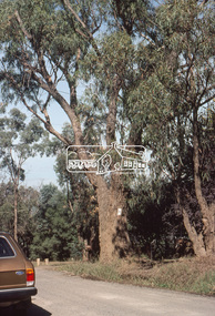
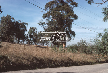
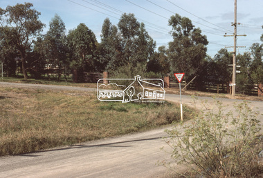
Slide, Bonds Road, Lower Plenty, Mar. 1981
One of a series of images of road infrastructure focussed on Bonds Road, Lower Plenty, the section connecting Old Eltham Road with Rosehill Road, taken by Eltham Shire Council Planning and Engineering officers. They provide perspective of the changes in housing styles and road development that began sweeping in from the mid 1970s with increasing urbanisation of what was once more outlying suburbs and regions. All images have been identified with GPS35 mm colour positive transparency (1 of 13) Mount - Kodak Kodachrome CardProcessed Mar 1981infrastructure, roads, bonds road, lower plenty, old eltham road -
 Eltham District Historical Society Inc
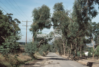
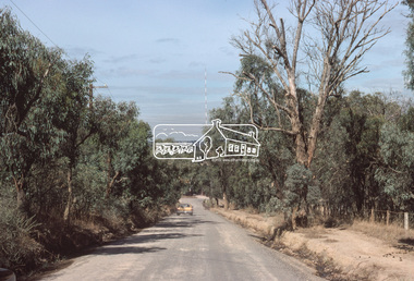
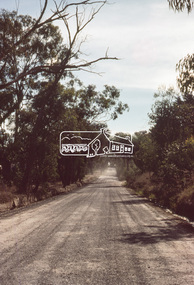
Slide, Bonds Road, Lower Plenty, Mar. 1981
One of a series of images of road infrastructure focussed on Bonds Road, Lower Plenty, the section connecting Old Eltham Road with Rosehill Road, taken by Eltham Shire Council Planning and Engineering officers. They provide perspective of the changes in housing styles and road development that began sweeping in from the mid 1970s with increasing urbanisation of what was once more outlying suburbs and regions. All images have been identified with GPS35 mm colour positive transparency (1 of 13) Mount - Kodak Kodachrome CardProcessed Mar 1981infrastructure, roads, bonds road, lower plenty -
 Eltham District Historical Society Inc
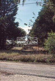
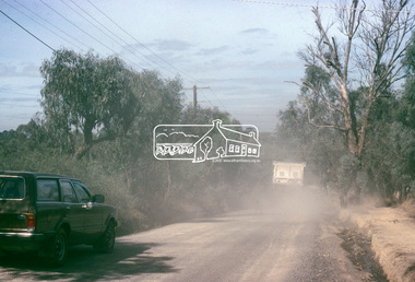
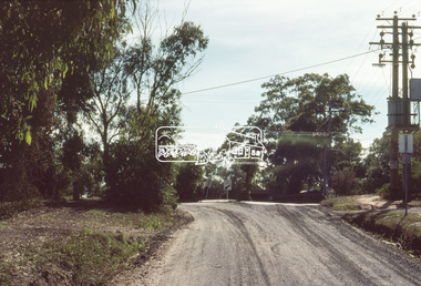
Slide, Bonds Road, Lower Plenty, Mar. 1981
One of a series of images of road infrastructure focussed on Bonds Road, Lower Plenty, the section connecting Old Eltham Road with Rosehill Road, taken by Eltham Shire Council Planning and Engineering officers. They provide perspective of the changes in housing styles and road development that began sweeping in from the mid 1970s with increasing urbanisation of what was once more outlying suburbs and regions. All images have been identified with GPS35 mm colour positive transparency (1 of 13) Mount - Kodak Kodachrome CardProcessed Mar 1981infrastructure, roads, bonds road, lower plenty -
 Eltham District Historical Society Inc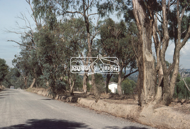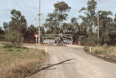
Slide, Bonds Road, Lower Plenty, Mar. 1981
One of a series of images of road infrastructure focussed on Bonds Road, Lower Plenty, the section connecting Old Eltham Road with Rosehill Road, taken by Eltham Shire Council Planning and Engineering officers. They provide perspective of the changes in housing styles and road development that began sweeping in from the mid 1970s with increasing urbanisation of what was once more outlying suburbs and regions. All images have been identified with GPS35 mm colour positive transparency (1 of 13) Mount - Kodak Kodachrome CardProcessed Mar 1981infrastructure, roads, bonds road, lower plenty, rosehill road -
 Eltham District Historical Society Inc
Slide, Bonds Road, Lower Plenty, Mar. 1981
One of a series of images of road infrastructure focussed on Bonds Road, Lower Plenty, the section connecting Old Eltham Road with Rosehill Road, taken by Eltham Shire Council Planning and Engineering officers. They provide perspective of the changes in housing styles and road development that began sweeping in from the mid 1970s with increasing urbanisation of what was once more outlying suburbs and regions. All images have been identified with GPS35 mm colour positive transparency (1 of 13) Mount - Kodak Kodachrome CardProcessed Mar 1981infrastructure, roads, bonds road, lower plenty -
 Eltham District Historical Society Inc
Slide, Bonds Road, Lower Plenty, Mar. 1981
One of a series of images of road infrastructure focussed on Bonds Road, Lower Plenty, the section connecting Old Eltham Road with Rosehill Road, taken by Eltham Shire Council Planning and Engineering officers. They provide perspective of the changes in housing styles and road development that began sweeping in from the mid 1970s with increasing urbanisation of what was once more outlying suburbs and regions. All images have been identified with GPS35 mm colour positive transparency (1 of 13) Mount - Kodak Kodachrome CardProcessed Mar 1981infrastructure, roads, bonds road, lower plenty, old eltham road -
 Eltham District Historical Society Inc
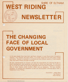
Newspaper - Folder, Shire of Eltham, West Riding Newsletter, 1978
Newsletter produced by the Shire of Eltham including introduction titled: "The changing face of local government", signed by Ward councillors: Helen Wells, Neil Roberts and Allan Horsley, a brief financial statement: "where the money comes from", roads, shopping centres, council/education department projects, land purchase, senior citizens and recreation include list of new construction and upgrades. Folder 71 from Harry Gilham Collection4 pages. Foldedallan horsley, community services, shire of eltham, budget, roads, shoppping centres, briar hill, montmorency, recreation, helen wells, neil roberts -
Ballarat Clarendon College
Trophy
Marching was a part of the CPLC athletics program. As part of the combined athletic meetings, marching contests occurred. Clarendon won in 1964, 1966 (shared) and 1968. The school houses also participated in an inter-house competition. Sir A W Nicholson served as a Council member from 1950, Treasurer 1959-1966 and Chair 1966-1973. He was agenerous donor to the school. The Nicholson library in the Junior School was named after him also Tall silver cup with double half-handles on melamine standInscribed on face of trophy: A W Nicholson Trophy / FOR / Marching / 1963 Sloss / 1964 Walker / 1965 Cairns / 1966 Walker / 1967 Sloss / 1968 Walker / 1969 Kennedy / 1970 Walker / 1971 Walker / 1972 Cairns / 1973 Slosssir-arthur-w-nicholson, clarendon-presbyterian-ladies-college, marching, athletics -
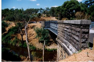 Greensborough Historical Society
Photograph - Digital Image, Anne Paul, Opening of restored Old Lower Plenty Bridge 2001 - side view of bridge, 14/03/2001
The opening of the restored Old Lower Plenty Bridge, opened on 14/03/2001 by the Minister for Environment and Conservation Sherryl Garbutt MLA and Mayor of Banyule Cr Dale Peters. The project was jointly funded by Banyule Council and Parks Victoria. The restored bridge is the oldest remaining bridge in the former Shire of Eltham and forms part of the Plenty River Trail. This photograph shows the bridge from the side elevation, showing the bluestone and iron construction.Digital copy of colour photographlower plenty, lower plenty bridge, sherryl garbutt, dale peters, banyule council, parks victoria -
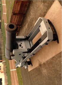 Glenelg Shire Council Cultural Collection
Photograph - Photograph - Battery Point, Portland, c. 1983
Glenelg Shire Council records. Built on land gazetted for defence purposes in the 1840s, Portland Battery was constructed in 1889 to defend Victoria against the feared Russian invasion. Batteries were also constructed at Warrnambool and Port Fairy during this period. The Battery comprises a magazine, upper chamber, a parapet wall, and three gun emplacements. In 1984 the Battery underwent a major restoration. The underground magazine and lamp passage are currently not accessible to the public.Picture of Cannon, Low Moore 68 lb, 1861, Battery Point, South Portland.portland battery, cannon, munition, fortifications, magazine, 1800s -
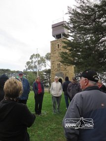 Eltham District Historical Society Inc
Photograph, Shire of Nillumbik World War One Memorials tour, 10 August 2016, 10 August 2016
As part of a program to acknowledge the Anzac Centenary Nillumbik Shire Council partnered with Yarra Plenty Regional Library to provide a bus tour with commentary of local sites of significance. These included Eltham township, the Shire of Eltham War Memorial at Kangaroo Ground, Christmas Hills, Hurstbridge memorial recreation park and finished at Eltham Library to view the Writing the War exhibtion at Eltham Library Community Gallery. Kangaroo Ground War Memorial Park.Born Digitalworld war 1, war memorials, shire of nillumbik, tour, kangaroo ground, shire of eltham war memorial -
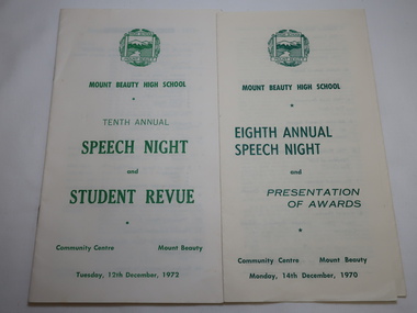 Kiewa Valley Historical Society
Mt Beauty High School Speech Night 1971 and 1972
Mount Beauty High School was proclaimed in 1963 with 213 pupils, 12 staff members. The enrolments and staff numbers increased as the Kiewa Hydro Electric Scheme continued to be constructed . 1. The Annual Report gives details re Accommodation, Grounds & Buildings, Equipment, Curriculum, Activities, Advisory Council, Cafeteria, Staff and Thanks. 2. In 1972, 27 teachers (names & subjects) are listed as well as other staff. The Reports are similar to that in 1970Mt Beauty High School grew quickly and then declined in numbers as the Kiewa Hydro Electric Scheme was constructed from the late 1940s to the 1960s. It is currently (2023) still operating serving the population in the Kiewa Valley. 1.Pale yellow paper folded x2 opening up to 3 columns of green print. 12 items listed followed by 'Extracts from the Eighth Annual Report. The Report contiues on the back. Front page has logo, title & date 14th Dec. 1970 2. Booklet of 12 pages (6 paper sheets)14 items on page 2, Staff listed on page 3, Principal's Report on page 4- 6. S.R.C. Report page 7, 10th Annual Report page 8-9,President's Report page 10. Scholarships & Awards page 11-12. Front page has logo and title. Tenth Annual Speech Night and Student Revue 12th December 1972 mt beauty high school, speech night programmes 1970 1972 -
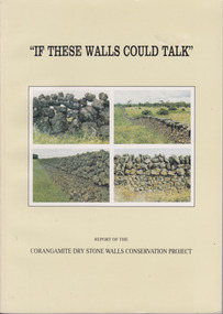 Warrnambool and District Historical Society Inc.
Book, If These Walls Could Talk, 1995
This publication is a result of funding made to the Corangamite Arts Council in 1990-91. Its aims were to identify and research the dry stone walls of the region, to raise their profile and through workshops continue the skills of those wanting to learn more about the craft. The book gives the history of the practice in the area and the various different styles with photographs to illustrate the different features. It also has a number of first- hand accounts written by stonewallers.This study has social, historical, artistic and interpretive significance as the walls are an important feature of the district. The account written by former builders of the walls provides an interesting insight into the various styles and reasons for their construction.Light green card cover. Front cover has 4 photographs of dry stone walls with title and other text in black. Back cover is plain. 144 pages. It contains a large number of black and white photographs of stone walls from around the district as well as maps. Report of the Corangamite dry stone walls Conservation project.dry stone walls, corangamite stone walls, warrnambool and district history, constructing dry stone walls -
 Ringwood and District Historical Society
Photograph, Edwin G. Adamson A.R.P.S, Vacant land back of Adelaide St. houses, Ringwood 1963 (Eastland Litigation Photos)
This series of SS0380 photos are part of the "Eastland Litigation" launched in 1962 by the Whitehorse Traders Co-operative Association (WTCA), against the Ringwood Council's Interim Development Order of 1960. WTCA sought "orders from the Supreme Court of Victoria that the planning scheme was invalid" - See "The Eastland Litigation" chapter in "From Horse Shoes to High Heels - Ringwood Shopping Centre and Eastland 1858-2008" by Richard Carter, Bounce Books 2009.2 photos taped to form a long horizontal photo. This taped photo was scanned in two parts and then merged using Photoshop. The two parts and the merged image are attached.Written on back of picture, 'Vacant land backs of Adelaide St. houses'. Stamped on back, 'In the Supreme Court - 13 Aug 1963' and 'Edwin G. Adamson....July 63'. -
 Ringwood and District Historical Society
Photograph, Edwin G. Adamson A.R.P.S, Back grocery, corner Adelaide St Ringwood 1963 (Eastland Litigation Photo) (2 views), May 1963
This series of SS0380 photos are part of the "Eastland Litigation" launched in 1962 by the Whitehorse Traders Co-operative Association (WTCA), against the Ringwood Council's Interim Development Order of 1960. WTCA sought "orders from the Supreme Court of Victoria that the planning scheme was invalid" - See "The Eastland Litigation" chapter in "From Horse Shoes to High Heels - Ringwood Shopping Centre and Eastland 1858-2008" by Richard Carter, Bounce Books 2009.Written on back of photograph 2826-2, 'Back grocery, corner Adelaide St.' Stamped on back, 'Edwin G. Adamson... [and samped] In the Supreme Court 13 Aug 1963'. On back of 2826-1 (similar photo at different time): Photo of the shop and dwelling ordered to be demolished - north-eastern corner of Adelaide St and Maroondah Hwy.