Showing 4566 items
matching tram 1
-
 Ballarat Tramway Museum
Album - Postcards & Photographs - Vic Solomons and others - Australian Tramways, Vic Solomons, 2023
... No 1 Unknown Launbceston 44 Post Card Tram 6 at Trevallyn... No 1 Unknown Launbceston 44 Post Card Tram 6 at Trevallyn ...Contains 184 images of postcards and photographs collected primarily by Vic Solomons of Sydney, with others from the collection of Wal Jack and Warren Doubleday. Covers almost all of Australia's tramway systems. 1 Post Card Hay St Perth Looking East No 3 Unknown Perth 2 Post Card Cars 30 & 90 both on Route 19 pass in Barrack St looking South Perth WA 1935.02.18 Perth 3 Post Card Hay St Looking East Perth WA Unknown Perth 4 Post Card William St Perth WA Unknown Perth 5 Post Card Perth from Shaftsbury Hotel Unknown Perth 6 Post Card Hay St Perth WA Looking East Unknown Perth 7 Post Card Barrack St Perth Unknown Perth 8 Post Card Murray Views No 3 High St Showing Town Hall Fremantle WA Unknown Fremantle 9 Post Card High St Fremantle WA Unknown Fremantle 10 Post Card View of Bolder City Golden Mile in the Background (Section No 1) 1908.08.20 Kalgoolie 11 Post Card Hannan St Kalgoolie 1900.08.19 Kalgoolie 12 Post Card Hannan St Kalgoolie WA (No 2) Unknown Kalgoolie 13 Post Card Intersection Hannan & Maritana Sts Kalgoolie WA Unknown Kalgoolie 14 Post Card Hannan St Kalgoolie Unknown Kalgoolie 15 Post Card Lane Street Bolder City Unknown Kalgoolie 16 Post Card Hobart Double Deck Tram Unknown Hobart 17 Post Card Macquarie St Hobart Unknown Hobart 18 Photo Liverpool Street Hobart Unknown Hobart 19 Photo Hobart 21 Unknown Hobart 20 Photo Hobart 14 in Elizabeth St Hobart Unknown Hobart 21 Post Card Macquarie St Hobart Unknown Hobart 22 Post Card Macquarie St Hobart Tas Unknown Hobart 23 Photo Double Decker Tram 3 at G.P.O. Hobart Tas No 31 Unknown Hobart 24 Post Card Double Decker Tram 19 Hobart Tas A B Series No 24 Unknown Hobart 25 Photo Hobart Municipal Tramways Tas No 95 Unknown Hobart 26 Post Card Elizabeth St Hobart Unknown Hobart 27 Post Card Elizabeth St Hobart Unknown Hobart 28 Post Card Elizabeth St Hobart Unknown Hobart 29 Post Card Elizabeth St Hobart Tas Unknown Hobart 30 Post Card HMT 21 with crew at Beach Road Terminus Unknown Hobart 31 Post Card HMT 9 & another with crew at Beach Road Terminus. Front cover photo of Destination GPO 1921.01.00 Hobart 32 Post Card Cascade Road and Mount Wellington Hobart Unknown Hobart 33 Post Card Elizabeth St Hobart Unknown Hobart 34 Post Card Elizabeth St Hobart Unknown Hobart 35 Post Card Elizabeth St Hobart 1915.04.07 Hobart 36 Post Card Macquarie St Hobart Tas Unknown Hobart 37 Post Card Macquarie St showing Post Office Hobart 1908.03.12 Hobart 38 Post Card Hobart Municipal Tramways 21 Unknown Hobart 39 Post Card Elizabeth St Hobart Tas Unknown Hobart 40 Post Card Liverpool Street Hobart Unknown Hobart 41 Post Card Electric Tram Launceston Tas 446 W J Little Photo 1919.02.08 Launbceston 42 Post Card Launceston Tram no 3 1911.08.30 Launbceston 43 Post Card Launceston Tram no 3 passes tram No 1 Unknown Launbceston 44 Post Card Tram 6 at Trevallyn a popular suburb Launceston Tasmania Unknown Launbceston 45 Post Card Tram 7 at Trevallyn Road Terminus Launceston Tasmania Unknown Launbceston 46 Post Card Tram 4 in Brisbane St Launceston Unknown Launbceston 47 Post Card Tram 9 in Brisbane St Launceston Tasmania Unknown Launbceston 48 Post Card Camerom Street Launceston Tasmania Unknown Launbceston 49 Post Card Murray Views No 15 Jetty Road Glenelg Terminus 1962-02-08 Adelaide 50 Post Card Bay Tram at Jetty Road Terminus Glenelg SA Unknown Adelaide 51 Post Card Tram 3 in King William Street Adelaide S Aust Unknown Adelaide 52 Post Card Valentine Series No 3065 The Old Horse Tram Victor Harbour Unknown Victor Harbour 53 Post Card Bourke Street Melbourne with Cable Car Looking East 1904.04.25 Melbourne 54 Post Card Opening of New Electric Tramway Elsternwick 1913-11-13 Melbourne 55 Post Card Cable trams in Clarendon St Sth Melb Unknown Melbourne 56 Post Card Pall Mall from Charing Cross Bendigo Unknown Bendigo 57 Post Card Tram 4 & 7 pass at The Fountain and Mitchell Street Bendigo Vic Rose Series P 3198 Unknown Bendigo 58 Post Card M&MTB 133 at Charing Cross bound for Eaglehawk Bendigo Vic Murray Views No 45 Unknown Bendigo 59 Post Card Pall Mall Bendigo Vic Unknown Bendigo 60 Post Card Charing Cross & Mitchell St Bendigo Trams passing 1919.00.00 Bendigo 61 Post Card Pall Mall Looking East Unknown Bendigo 62 Post Card Electric Trams and City Hotel Bendigo Vic Unknown Bendigo 63 Post Card Moorabool Street Geelong V 23 Unknown Geelong 64 Post Card Murray Views No 3 Moorabool Street Geelong Vic Unknown Geelong 65 Post Card The Rose Series P 2487 Ryrie Street Geelong Vic Unknown Geelong 66 Post Card Southern Cross Series 2696 Ryrie Stret Geelong Vic Unknown Geelong 67 Post Card The Rose Series P 1490 Ryrie Street Geelong Vic 1920-03-04 Geelong 68 Post Card Valentine Series No 1568 Lower Sturt Street Ballarat Unknown Ballarat 69 Post Card Rose Series P 1710 Sturt Street Ballarat Victoria Unknown Ballarat 70 Post Card Sturt Street Ballarat Victoria Unknown Ballarat 71 Post Card Horse Tram In Sturt Street Ballarat 1905.11.10 Ballarat 72 Post Card Sturt Street Ballarat Looking North-West Unknown Ballarat 73 Post Card Shoppes Square Sturt Street Ballarat Looking North Unknown Ballarat 74 Post Card Junction Sturt and Lydiard Streets Ballarat 1909-09-01 Ballarat 75 Post Card The Electric Supply Co Souvenir Tram Ticket No 3085of the opening of Electric System August 18 1905 1905.08.18 Ballarat 76 Post Card Sturt Street Ballarat Victoria 1907.11.25 Ballarat 77 Post Card Off to the Gardens Electric Tram Ballarat Unknown Ballarat 78 Post Card Sturt Street Ballarat 1907.04.16 Ballarat 79 Post Card Sturt Street Ballarat Looking East Electric tram with Double Deck Trailer 1911.04.17 Ballarat 80 Post Card Sturt Street Ballarat Looking East Unknown Ballarat 81 Post Card Sturt Street Ballarat Looking West 1911.03.01 Ballarat 82 Post Card Town Hall and Sturt Street Ballarat Unknown Ballarat 83 Post Card Lydiard Street Ballarat 1906.11.23 Ballarat 84 Post Card Looking North along Adelaide Street from George Street Brisbane Sidues Series No 764 Unknown Brisbane 85 Post Card Looking South along Queen Street from the Creek Street Intersection Brisbane Qld Sirues Series No 1379 Unknown Brisbane 86 Post Card George Street from near Supreme Court Brisbane Unknown Brisbane 87 Post Card Queen and Eagle Streets Brisbane 1907.07.04 Brisbane 88 Post Card Queen Street showing His Majesty’s Theatre Brisbane Unknown Brisbane 89 Post Card Queen Street Treasury Building 1908.01.20 Brisbane 90 Post Card G P O and Queen Street Brisbane Unknown Brisbane 91 Post Card Queen Street Brisbane Looking from Wharf Street Unknown Brisbane 92 Post Card Customs House Brisbane 1905.02.16 Brisbane 93 Post Card Queen St Brisbane 1905.09.16 Brisbane 94 Post Card Queen St Brisbane 1907.11.19 Brisbane 95 Post Card Treasury Buildings Brisbane Unknown Brisbane 96 Post Card Queen and Eagle Streets Brisbane Unknown Brisbane 97 Post Card The Valley Corner Brisbane Unknown Brisbane 98 Post Card Brisbane Queen Street opposite General Post Office Unknown Brisbane 99 Post Card North Quay and Milton Beach Brisbane Q Unknown Brisbane 100 Post Card Victoria Bridge Brisbane South Side 1907.08.14 Brisbane 101 Post Card Victoria Bridge Brisbane Unknown Brisbane 102 Post Card Breakfast Creek Bridge Brisbane Q Unknown Brisbane 103 Post Card Melbourne Street Station South Brisbane Queensland Unknown Brisbane 104 Post Card General Post Office Queen Street Brisbane 1955.09.23 Brisbane 105 Post Card Customs House Brisbane 1904.11.04 Brisbane 106 Post Card Queen St Brisbane 1919.11.00 Brisbane 107 Post Card Queen St Brisbane Sidues Series No 627 Unknown Brisbane 108 Post Card Creek Street Brisbane Queensland Unknown Brisbane 109 Post Card Customs House and Garden Reach Brisbane Queensland 1910.00.08 Brisbane 110 Post Card Queen and Creek Streets Brisbane 1909.06.07 Brisbane 111 Post Card Queensland National Bank andd Queen Street Brisbane Queensland Unknown Brisbane 112 Post Card Queen Street and Treasury Buildings Brisbane 0000.09.07 Brisbane 113 Post Card Queen Street showing “Courier” Buildings Brisbane Unknown Brisbane 114 Post Card Intersection George & Roma Streets Brisbane Q 1916.05.11 Brisbane 115 Post Card Adelaide Street Brisbane Q Unknown Brisbane 116 Post Card G P O Queen Street Brisbane Q Unknown Brisbane 117 Post Card Treasury Building Brisbane 1906.03-20 Brisbane 118 Post Card Queen and Eagle Streets Brisbane 1907.02.01 Brisbane 119 Post Card Queen St Brisbane Unknown Brisbane 120 Post Card Queen St Brisbane Q Unknown Brisbane 121 Post Card Victoria Bridge Brisbane 1906.07.30 Brisbane 122 Post Card An Unusual View showing Head of Queen Street Victoria Bridge & South SideSuburbs Brisbane Q Unknown Brisbane 123 Post Card Petries Bight Brisbane Q Unknown Brisbane 124 Post Card South End Victoria Bridge Brisbane Q Unknown Brisbane 125 Post Card Customs House Brisbane Unknown Brisbane 126 Post Card Photo of toastrack car circa 1910 Unknown Brisbane 127 Post Card Treasury Buildings Brisbane Unknown Brisbane 128 Post Card East Street Rockhampton with Steam Tram & trailer Unknown Rockhampton 129 Post Card Post Office Rockhampton with steam tram Unknown Rockhampton 130 Post Card East Street Rockhampton with Steam Trams Rose Series P 7154 Unknown Rockhampton 131 Post Card William Street Rockhampton Rose Series P 7156 Unknown Rockhampton 132 Post Card Central East Street Rockhampton Q with Steam Trams Unknown Rockhampton 133 Photo Sturt St Ballarat Unknown Ballarat 134 Photo Bridge Street Ballarat Unknown Ballarat 135 Post Card George St Sydney Unknown Sydney 136 Post Card Elizabeth St Sydney Unknown Sydney 137 Post Card Railway Square Unknown Sydney 138 Post Card Sydney Harbor Bridge - pending receipt 139 Post Card Kings Cross - Mowbray Series with description on rear from C Roy G Field Unknown Sydney 140 Post Card Kings Cross - Mowbray Series with description on rear from C Roy G Field Unknown Sydney 141 Post Card Central Railway Station Sydney - Rose Series P6033 1954-01-26 Sydney 142 Post card William Street Darlinghurst looking towards City - Rose Series P6602 unknown Sydney 143 Post Card Circular Quay Sydney - Rose Series P6680 Unknown Sydney 144 Post Card View at Manly NSW - Rose Series B1003 Unknown Sydney 145 Post Card Hunter St Newcastle NSW - Rose Series P7843 Unknown Newcastle 146 Post Card Bank Corner Newcastle NSW - Mowbray Series No. 155 Unknown Newcastle 147 Post Card Hunter St Newcastle NSW Unknown Newcastle 148 Post Card Criterion Hotel Hunter St Newcastle NSW Unknown Newcastle 149 Photo Horse tram at Newtown Station 1894 to 1898 - PTC photo c1894 Newtown 150 Photo Steam tram motor No 3 at Railway Square 1879 1879 Sydney 151 Photo Railway steam tram c1900 with a horse drawn double deck bus c1900 Sydney 152 Photo Steam motor 5A and doubled deck bus Unknown Sydney 153 Photo Steam motor 53A with detail notes on rear 1922 Sydney 154 Photo Cable tram set at Milsons Point ferry terminal c1900 Sydney 155 Photo Early Sydney electric car - Ocean St - Rose Bay Unknown Sydney 156 Photo George St looking souoth c1905 c1905 Sydney 157 Photo Tram 165 at Circular Quay Unknown Sydney 158 Photo Tramcar ferry or transporter at The Spit Unknown Sydney 159 Photo tram 882 George St at Marti Place, 1937 1937 Sydney 160 Photo Tram 826 Railway Sq area Unknown Sydney 161 Photo Railway Sq in background, Broadway with double decker bus and toastrack car late 1930s Sydney 162 Photo Coupled St Pitt St? - photo Ben Parle Feb. 1950 Sydney 163 Photo Electric tram No. 2 - North Sydney with side trolley pole running Unknown Sydney 164 Photo George St - Horden's Corner Unknown Sydney 165 Photo George St at Martin Place c1920 Sydney 166 Photo Castlereagh St Sydney c1928 c1928 Sydney 167 Photo Railway Sqare c1920 c1920 Sydney 168 Photo Darling St Countereweight Unknown Sydney 169 Photo Trolley bus depot Unknown Sydney 170 Photo Trolley bus No. 14 Unknown Sydney 171 Photo Newcastle Railway Station with steam tram - Wharf Road?? Unknown Newcastle 172 Photo High St West Maitland - steam tram Unknown Maitland 173 Photo High St West Maitland - steam tram Unknown Maitland 174 Post Card Argent St near tram terminal Broken Hill NSW c1900 Broken Hill 175 postcard Argent St looking south Broken Hill - with Ken Magor's notes on rear Unknown Broken Hill 176 Photo Toronto - steam tram 61A Unknown Toronto 177 Photo 124A trial run 1911? Sutherland - Cronulla line 1911 Sutherland 178 Photo 103A at a tram stop Unknown Sydney 179 Photo Cable tram set at Crows Nest terminus grip car 12, trailer 22 Unknown Sydney 180 Photo Cable tram Queens Square Sydney 1903 Sydney 181 Photo cars 2078 and 2077 Chatswood late 1950s Sydney 182 Photo car 1877 Balmain area late 1950s Sydney 183 Photo Trolley bus - Rockdale destination Late 1950s Sydney 184 Photo Broken Hill steam tram - motor 18A North Tram Unknown Broken Hill 185 Photo Millars Point Sydney NSW - ferry/tram interchange, unknown Sydney All items imaged including the rear or back where there was writing of information. All files stored on the Museum's Photo Collections directory. Demonstrates through the medium of many images, Australian tramway systems and Ballarat's place in them.Album - heavy card covers, plastic lined with postcard or 6x4 photo sleeves.australia, tramways, postcards, photographs, steam trams, horse trams, cable trams, trolley buses -
 Melbourne Tram Museum
Album - Photo Album, John Etkins, Ray Marsh, 1990's
... Annual Report? 1 957 City Circle 1 “hands off our trams... City Circle 1 “hands off our trams” protest march 2 2100 ...Photo Album - 48 sheets bound with a white circular metal/plastic spiral bound within a heavy duty cardboard cover, with glued cover pages, plastic covered with an index sheet. Allows for three photographs per page. Not known whether the plastic envelope for each photograph is of archival quality. No Manufacture detail, though has a bar code on the bottom left hand corner of the rear cover. Cover is a reproduction from a painted art piece. Listing of photographs given on htd1800-RayMarshalbum.pdf Dates given when written on the rear of the photograph. Compiled by John Etkins from photographs given to him by Ray Marsh. 1990's to 1993 generally. Page Tram/s Notes – dates given when on rear of photograph. 1 226 Loading passengers – ex MMTB Annual Report? 1 957 City Circle 1 “hands off our trams” protest march 2 2100, 231 South Melbourne Depot – 10-4-1993 2 676 And many others – Hawthorn Depot 2 217 Princes Bridges 3 380, 104 St Kilda Road 3 106, 104 Essendon Depot 3 431 As a W1 4 1011 Fresh fruit tram, Preston Depot 6-12-1992, 4 824 Day in Day out, Brunswick and Victoria Parade 29-4-1993 4 722 Art tram 5 ? Advert tram – Imperial China 5 237 Stubbsy tram – TrippleM? 6 856 City Circle – with gas and fuel building – 31-7-1994 6 925 City Circle - with gas and fuel building – 31-7-1994 6 728 City Circle – 10-8-1994 7 246 Navy tram x three pics – July 1992 8 ? Gold tram advertising Georges 8 990 Advertising Telstra– 29-4-1993 8 749 Art tram? 9 990 NRMA - 1-3-1994 9 727, 215 Public Transport 9 920 Advert tram with a picket fence 10 Bendigo 21 Preston Workshops 11-3-1993 10 774? W5 being rebuilt at Preston – 21-10-1991 11 ? Bogie cable trailer at Preston – 29-4-1993 11 922 Interior view of a tram – being modernised – 11-3-1993 11 922 Preston Workshops 29-4-1993 12 1018 Workcare tram at Preston 1994 – 11-8-1994 12 774 Preston Workshops – 20-12-1993 12 8 Preston Workshops – 1-10-1992 13 380 Preston Workshops 13 8 Preston Workshops 13 20, 8 Preston Workshops 14 721 Preston Workshops 20-12-1993 14 ? Tramways painted artist tram featuring a driver and workshop 14 Traverser Preston Workshops 15 2110, 2106 Preston Workshops 15 ? Preston Workshops 15 2130 Interior Preston Workshops 20-12-1993 16 Set of three pics Elizabeth St floods – 17-2-1972 17 Set of three pics Elizabeth St floods – 17-2-1972 18 676 Turning into Swanston St from Batman Ave 18 676 Kew Depot – 10-11-1991 18 237, 676, 611 Kew Depot – 10-11-1991 19 214, 676 South Melbourne Depot – Kingsway 19 217 Spencer St 19 214 Advertising Kew Depot Open Day -8-12-1991 20 231, 676 Advertising Kew Depot Open Day -8-12-1991 20 Zoo tram, 256 Outside Kew Depot 20 214 Hawthorn Open Day with band 21 Zoo tram x 3 pics And horses, Kew Open day 22 231, 431 Kew Depot 22 892, 214 Kew Depot 75 years, Postcard – 1991 22 282 Kew Depot – with the name Monique on the tram and a lady standing alongside 23 238, 233 Kew Depot 23 236, 892, 282 Kew Depot – 25-4-1992 23 232, 236, 282 Kew Depot 24 2112 Port Melbourne line – with long grass – 11-4-1993 24 469, 2037, ? 2015 South Melbourne Depot 24 1018 or 976? Advertising a PTC Open Day – 20-10-1991 – In Swanston St - see Reg Item 1845 25 250 Bourke St 25 2100 Running into Preston Workshops 25 282, 1003 Collins St in the rain 26 Logo PMTT 26 Point cover With P&MTT cast into the cover 26 Foundation Stone Person reblocking in gold, a PMTT Foundation Stone 27 Logo Tramway Board 27 Logo MMTB logo 27 Logo Footscray Tramways Trust 28 217 And 2’gauge W2 – South Melbourne Depot – 20-10-1991 28 164 Somewhere? 28 1018 Advert tram – “Moro”, Preston flyover 29 V214 x 3 pics Kew Depot 30 611 Whitehorse Road, Balwyn 5-10-1991 30 976 x 2 pics Advert tram – have a red instead 31 610 Malvern Depot 31 138 (max tract) Flinders St 31 138 (max tract) Bourke into Spencer 32 844 Victoria Parade with R10 behind 32 264 With a TV interview being undertaken 32 2066 Elizabeth St – 29-4-1993 33 255 x 2 pics Derailed at Kew Depot 33 253 Derailed outside the Beehive Hotel 34 214, 892, 611 Re-enactment of Victoria Bridge to Esplanade service – 10-11-91 34 726 Art tram? – Swanston St with overhead trucks in background 34 10W Reblocking scrubber car at Brunswick Depot 1999 35 2085 At Preston workshops over an inspection track section 35 731 St Georges Road, road being rebuilt – Nov. 1991 35 Preston Jtn Junction at Workshops being relaid 36 1003 St Georges Road, Nov. 1991 trackworks 36 St Georges Rd Track being rebuilt – Nov. 1991 has temp track cross over 36 Victoria St Victoria St being reconstructed 6-9-1992 37 East Burwood Extension works – 18-2-1993 37 East Burwood Re-building crossover – 18-2-1993 37 Victoria St Victoria St being reconstructed 6-9-1992 38 19W, 16W Bylands – 5-12-1993 38 R10 Kew Depot 38 Workers Kew Depot pushing on a post 39 R10 R10 towing a B class tram- Royal Parade? 39 11W, 10W? South Melbourne Depot 39 Overhead Overhead truck at Kew Depot 40 Kew Depot Demolition works opposite depot 40 613? Malvern Depot on special tram 40 256 zoo tram Royal Park tram at Kew Depot 41 B class Bundoora line 1993 41 231, 611 Kew depot 75th anniversary tram 41 469, 287 Kew depot 42 510 Spring St into Bourke St – 28-4-1993. “42nd street promotion. 42 153 High St Northcote, Bundoora 42 611 Kew Depot, Nov. 1991 43 195? Simpson St siding – 25-4-1993 – 7 trams in all 43 646 Route 12, with fire station in background – Gisborne and Victoria 43 961 Burke Road, Camberwell, 10-8-1994 44 760 Art tram 44 938 Sam the tram, Flinders St 44 1014 Gilbert Road, West Preston, June 1994, advert for AGC 45 965 Daimaru advert tram, Swanston St 45 1018 Express post advert tram, Swanston St. 45 1024 Advert – lego exhibition – Swanston St 46 104 Camberwell depot 46 611 Looking towards driver’s controls from interior. 46 W1 Interior photo showing tip over seats 47 Cable car Interior photo – could be zoo tram 47 510 Interior, 28-4-1993 47 214 Kew Depot, night shot, Oct. 1991 48 246, 237 Kew depot, 13-9-1993 – Stubbsy and Energy Victoria advert 48 246, 231, 237 Kew depot, Navy, 75th anniversary of Kew and Fox Fm advert 48 2014, 2072 South Melbourne – tt line? Advert tram 49 59 And six other trams in front of Preston Workshops 49 1024 MMTB Christmas Tram, 1970 49 2001 Camberwell Depot 50 725 Preston depot area – tram has a red upper half 50 725 South Melbourne depot – now has Xmas decorations 50 1026 Bourke St, Christmas 6-12-1993 51 933 Victoria Parade shunt and other A class tram – Autumn 51 829 Art tram 51 39 Advert tram – Crime prevention 52 Connie Connie at night = has jeans on 52 1?? Has a MET inspector standing in front of number – Latrobe uni tram 52 611 Kew Depot 53 237 Fox FM Black Thunder tram at Kew Depot, August 1992 53 237, 611, 892 Victoria Bridge re-enactment – 10-11-1991 53 237 At Kew depot with 4 people, including Hugh Waldron 53 442, 10W South Melbourne Restaurant tram and works car 53 W2 At Wattle Park 53 School art Photo of students holding artwork on the zoo tram 256 at Kew 54 138 And many others 54 469 Launch of the Melbourne Tram by the PTC 54 School art Photo of students holding artwork on the zoo tram 256 at Kew 55 B2 Elizabeth St terminus, Christmas 1994 55 8 Z8 Swanston St, April 1993 55 504 Clifton Pugh – Preston Workshops 56 138, 180, 214 Hawthorn Depot display 56 650, 510 Hawthorn Depot 56 469 Camberwell 57 568 Bridge Road Richmond by cable tram depot 57 ? Advert tram – Falls Creek 57 995 Malvern Road, 18-5-1992 58 457, 217 etc Swanston St display 58 231, 611 Kew 75th Anniversary 58 682 Artist tram at Malvern Depot – 18-5-1992 59 1018 Country Road advert tram 59 8 Z class – decorated tram – Essendon Depot 59 947 Metland Safety Express – safety tram – Kew depot 60 101 x 2pics Decorated for RAAF 70th Anniversary 60 2082 Near East Preston Depot, with destination “Next Stop Mill Park” 61 475 After sale and disposal 61 585 After sale and disposal 61 651 After sale and disposal – Diamond Creek – 9-8-1994 62 386 After sale and disposal – Sunbury 62 590 After sale and disposal – Hall ACT 62 476 After sale and disposal – Kinglake 63 11W Bundoora Extension – track being opened 63 947 Metland Safety Express – safety tram – Kew depot 63 Model 2,3 2’ gauge model trams 64 Model 2 Ditto 64 250 After sale and disposal 64 293 After sale and disposal – Diamond Ck – 9-8-1994 65 246, 231, 237 Kew depot, Navy, 75th anniversary of Kew and Fox Fm advert 65 1002 Advert tram – Salvation Army 65 231, 29 Kew Depot 66 246, 231, 237 Kew depot, Navy, 75th anniversary of Kew and Fox Fm advert 66 646, 935, 1002 Kew depot 66 220, 60 Preston Workshops? 67 851, 814 Malvern Depot 3-9-1992 67 726 Malvern Rd at Glenferrie Road – 18-5-1992 67 237, 133 Victoria Parade 1996 68 814 and others Interior Malvern Depot – 18-5-1992 68 231 75th Kew depot anniversary at depot 68 231 75th Kew depot anniversary at depot 69 1024 Malvern Depot 10-11-1991 69 1011 Advert tram Melbourne City Toyota 69 106, 180 Swanston St 70 190, 568 Camberwell Depot 70 431 Flinders St – tram event 70 20, 138 Camberwell Depot 71 431 Flinders St – tram event 71 237 Fox FM Thunder Tram 71 2057, 2014 Elizabeth St, Vic Market 29-4-1993 72 676, 611, 892 Victoria Bridge re-enactment – 10-11-1991 72 Ceremony Victoria Bridge – mayor and others event 72 214 214 on the bridge 73 164 Lygon St – former outer circle line level crossing in view 73 841 Swanston Walk 29-4-1993 74 821 St Georges Road, April 1993 74 431, 231 Victoria Parade 74 217, 676 Passing Camberwell Depot 75 Oporto 018 Clarendon St 6-3-2003 75 3007 Albert Park – 7-3-2003 75 3001, 018, 3502 Docklands – 10-3-2003 76 Oporto 018 Docklands – 16-1-2003 76 Oporto 018 Flinders St 7-3-2003 76 3502 Swanston St at Flinders St -8-3-2003 77 16 Kew Depot, Jan 1991 77 112, 110 Bundoora 4-9-1992 77 738 Camberwell Feb 1991 78 1011 Thornbury Jan 1991 advert for City Toyota 78 101 Bundoora – RAAF tram 4-9-1992 78 814 Art tram – Swanston St August 1992 79 1024, 469, Z3 Preston Workshops – 469 as the Melbourne Tram – 9-9-1992 79 961 Malvern Depot 3-9-1992 79 242 Single line working in Victoria St 6-9-1992 80 781 Thornbury, the hump, Preston Workshops Jan 1991 80 2104 Preston Workshops 9-9-1992 80 2100 Launch, Preston Workshops 9-9-1992 81 5W + 1A 5 x W at Kew Depot 3-2-1991 81 676 Kew Depot 21-2-1991 81 873, 2016 Brunswick depot 2-3-1991 82 231 Kew Depot Yard – 21-1-1991 82 157, 158 Brunswick Depot – 2-3-1991 82 2057, 873, 158 Brunswick Depot – 2-3-1991 83 802 Art Tram - Franklin St from the signal box 2-3-1991 83 990 990 Evian advert tram, Franklin St signal box 2-3-1991 83 920 GIO Advert Tram with Bushels tea and Yellow Pages? Adverts 84 721 Art Tram, Franklin St signal box 84 976 St Georges Road, Jan 1991 – advert tram Capital society 84 731 St Georges Road, Jan. 1991 Art tram 85 10W Victoria Parade, Brunswick St, 1/3/1991 85 10W, 9 or 11W South Melbourne depot 85 10W Bundoora Terminus 4-2-1991 86 11W City Baths 86 10, 16 Camberwell Depot 6-12-1990 86 944 Glenhuntly Depot 18-2-1991 87 2011 Spring St – Princess Theatre, March 1990 87 294, 239, 277, 243, 259, 280 Kew Depot 87 296 Kew Depot 88 1015, 16 Batman Ave 19-1-1991 88 963, 948, 935, 996, 892 Kew Depot 3-2-1991 88 Victoria St Victoria St Richmond Reconstruction 6-2-1992 89 1014, 990 Batman Ave 19-1-1991 (Image added i5 and rear view added 23-12-2018, scanned for Dale Budd. 89 920 920 – GIO advert tram, 760 art Tram Collins at Spencer 17-10-1990 89 610, 611 Kooyong Station level crossing 30-12-1990 90 95 Royal Park, 15-2-1991 90 2057, 873, 158 Brunswick Depot – 2-3-1991 90 10 Camberwell Depot 6-12-1990 91 Bendigo 44 In Prahran and Malvern Tramways Trust Colours 1986 –Black and white photo. Listed 5-11-2016See note page 1 and on image 3trams, tramways, album, photo album, tramcars, the met, yarra trams, kew depot, brunswick depot, advertising trams, transporting art, preston depot, hawthorn, bundoora, st georges rd, victoria st, camberwell depot, tram r10, 8, 10w, 10, 11w, 16, 16w, oporto 018, 19w, 20, bendigo 21, 29, 39, bendigo 44, 59, 60, 95, 101, 104, 106, 110, 112, 133, 138, 153, 157, 158, 164, 180, 190, 195?, 214, 215, 217, 220, 226, 231, 232, 233, 236, 237, 238, 239, 242, 243, 246, 250, 253, 255, 256, 259, 264, 277, 280, 282, 287, 293, 294, 296, 380, 386, 431, 442, 457, 469, 475, 476, 504, 510, 568, 585, 590, 610, 611, 613?, 646, 651, 676, 682, 721, 722, 725, 726, 727, 728, 731, 738, 749, 760, 774, 781, 802, 814, 821, 824, 829, 841, 844, 851, 856, 873, 892, 920, 922, 925, 933, 935, 938, 944, 947, 948, 957, 961, 963, 965, 976, 990, 995, 996, 1002, 1003, 1011, 1014, 1015, 1018, 1024, 1026, 2001, 2011, 2014, 2015, 2016, 2037, 2057, 2057, 2066, 2072, 2082, 2085, 2100, 2104, 2106, 2112, 2130, 3001, 3007, 3502 -
 Eltham District Historical Society Inc
Document - Folder, McLean, 1984-1999
References to McLean family, Hector John McLean and Louisa Frances (nee Green) and six daughters who lived in Eltham during the period 1930 to 1934 inclusive. Lived in the former Evelyn Hotel at the time it was destroyed by fire and being part of the Centenary Parade in 1934 where the family won the Group Section for their entry “Pioneers of Eltham” Reminiscences provided by Edith Jones (nee M1934 flood, ballroom, baptism, barber shop, bittern, boy scouts, bremner's flat, burgoyne's shop, cable tram, cemetery road, centenary celebrations, centenary parade, christening, coach house, collis grocery, dalton street, depression, dole, dorothy jean mclean, edith jones (nee mclean), eltham fire brigade, eltham high school, eltham higher elementary school, eltham lower park, eltham railway station, eltham state school no. 209, evelyn hotel, fire damage - buildings, flinders naval depot, fordham, gladys evelyn mclean, gold mining, gwenneth mae mclean, gwladys evelyn mclean, headmistress, hector john mclean, isherwood house and shop, louisa frances mclean (nee green), metery road, methodist church, miss finnin, miss grant cottage, motor bike races, mrs barrett, mrs bremner, mrs hurley, olive isabel mclean, parade, phoebe lillian mclean, picnic, pioneers of eltham, pitt street, research fire brigade, rev. r.g. arthur, shed, shops, st margarets church hall, st margaret's church, stables, state savings bank of victoria, susso books, todaro, vinnie willet, warrandyte bridge, warrandyte, wingrove park, yarra river -
 Glen Eira Historical Society
Article - CARNEGIE
Four items about unconnected events in Carnegie dating from 1924 to 2011: 1/Photocopied flyers about forthcoming FINE VIEW ESTATE subdivision held on 29/03/1924, includes photocopied photos. 2/Cardboard flyer advertising Carnegie’s community singing at the Progress Hall, Truganini Road. 3/Newspaper article dated 19/03/1980 from the CHADSTONE PROGRESS on Robert Temminghoff, the new president of the Carnegie Chamber of Commerce. 4/MELBOURNE WEEKLY BAYSIDE 06/04/2011, an article on Carnegie, beginnings and other relevant facts.fine view estate', sub divisions, ormond, carnegie station, houses, housing estates, trams, glen huntly tram, shops, crystal palace theatre, caulfield, state school -
Glen Eira Historical Society
Document - Glen Huntly Fire Station
This folder contains 3 copies of photographs plus notes about the Glen Huntly Fire Station: 1/A print of a small black and white photograph (95mm x 127mm) of the exterior of Glen Huntly Fire Station accompanied by typed notes sourced 13/03/2007 from the Melbourne Fire Brigade Museum. The notes indicate that the fire engine shown parked out the front was in service 1919 to circa 1924: Car 55 Rego 8499 Hose Carriage Engine No. 3178 Napier. 2/An A4 sepia copy of the same photograph (210mm x 291mm) with street advertising of one of the shops clearly visible: 'DRAPERY EMPORIUM. UNDERCLOTHING BABY LINEN; HOSIERY HABERDASHERY MILLINERY'. The electric tram at the terminus on Grange Road is also seen in the photograph. Noted on the reverse of the photo: 'Glen Huntly Road and Grange Road' in pencil. 3/A photocopy of a black and white photograph (154mm x 200mm) of Fire Engine with No. 13197 outside the Glen Huntly Fire Station. Two firefighters are seated in the carriage and three others stand on the running board. It is noted 'D DISTRICT' at the top and 'No. 29 STATION GLENHUNTLY' on the bottom.glenhuntly, glen huntly fire station, glen huntly road, glenhuntly road, grange road, eastern hill fire station, electric trams, metropolitan fire brigade board, fire stations, fire brigades, fire engines, firefighters, firefighting equipment, hose carriage engine no 3178 napier, glen huntly, melbourne fire brigade museum, russell david -
 Glen Eira Historical Society
Historical Caulfield to 1972, photo album by Jenny O’Donnell, Glen Huntly Rd
... Drapery T Grogan drapery Emporium Glen Huntly Rd Electric Trams ...1 photo of T Grogan drapery Emporium, crowds gathered for opening day of Glen Huntly Rd Electric Trams 13/11/1913elsternwick, buildings, glen huntly rd drapery, t grogan drapery emporium, glen huntly rd, electric trams, o’donnell, jenny -
 Greensborough Historical Society
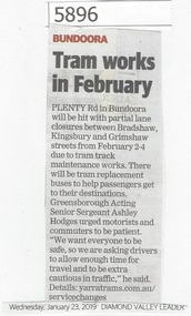
Newspaper Clipping, Diamond Valley Leader, Tram works in February, 23/01/2019
... public transport News article 1 page, black text. Tram works ...Plenty Road in Bundoora will be hit with partial lane closure between Bradshaw, Kingsbury and Grimshaw Streets from February 2-4 (2019) due to tram track maintenance works.News article 1 page, black text.plenty road bundoora, closure, tram track maintenance works, public transport -
 Greensborough Historical Society
Newspaper Clipping, Diamond Valley Leader, Think Tank for trammy, 07/03/2018
The life of Melbourne's happiest tram driver Bruce Whalley got even happier last year when the dapper bow-tie wearing bon vivant was invited to be on the ABC's latest quiz show, Think Tank.News article 1 page, black text and colour image .bruce whalley, think thank - abc, greensborough -
 Greensborough Historical Society
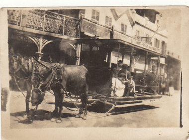
Photograph - Digital image, Charles Marshall et al, Port Said Tramway 2, 1917-1918
This photograph shows the tramway at Port Said. This photo was sent to Charles' brother Gillie.Digital copy of black and white photograph. "For Gillie, Port Said Tram service"charles marshall, world war 1 -
Glen Eira Historical Society
Newspaper - MELBOURNE AND METROPOLITAN TRAMWAYS: TRAMS
This file contains 2 items about the organisation. 1/Copy of photograph of horse-drawn tram. The image is of a tram behind 2 horses, unidentified tramway official, a lady and child. Date and location unknown 2/Original 4 page document including 4 images. Document is titled ‘The Development of Melbourne’s trams’ issued by the Melbourne and Metropolitan Tramways Board as part of M.M.T.B. News dated 1965. The document details the development of trams in Melbourne from 1860 followed by the 1869 formation of The Melbourne Omnibus Company and then the creation of The Melbourne and Metropolitan Tramways Board in 1919. Document covers the operations of horsedrawn trams, cable trams and electric trams and buses until 1965. Document also shows 4 images of various trams, ie horse drawn cable and electric trams.the melbourne and metropolitan tramways board (m.m.t.b), horse tramways, tram companies, trams, public transport, tram services, elsternwick railway station, land transport, glenhuntly road, caulfield railway station, glenhuntly railway station, prahran and malvern tramways trust, buses, point ormond bus, point ormond shuttle tram, tram depots, melbourne tramway and omnibus company, melbourne tramways trust, melbourne omnibus company, glenhuntly tram depot -
 Glen Eira Historical Society
Document - PRAHRAN AND MALVERN TRAMWAYS TRUST
This file has 3 items. 1/Photocopy of Caulfield Conservation Study Report by Andrew Ward dated January 1995 of 6-8 Rusden Street, Elsternwick being former Prahran and Malvern Tramways Trust substation. Report includes image, existing registrations, description of substation building and condition. 2/Original photograph (black and white) of tram shelter at corner of Balaclava Road and Orrong Road, Caulfield North, outside Grimwade House (school), description written on back of photo. 3/Original copy of magazine of the Tramway Museum Society of Victoria Ltd. ‘Running Journal’ Vol 7 No. 3 dated June 1970. Article (pages 3-7) entitled ‘Feeding & Filling, The Story of the Prahran & Malvern Tramways Trust’ written by Graeme Breydon. Article written for the 60th anniversary of the trust which opened for business on 30/05/1910 and describes the establishment and development of Tramways between suburbs of Malvern & Prahran including Elsternwick, Caulfield & Glen Huntly. Article includes 4 images plus map and diagram. Included: Photograph 3: Opening ceremony of tramway extension from Balaclava junction to Elsternwick railway station on Glen Huntly Road dated 13/11/1913. Diagram of various tramway routes including Prahran & Malvern Tramways Trust routes.prahran and malvern tramways trust, p+mtt, tram companies, land transport, public transport, substation, tram shelter, powerhouse, parapet, brick, stuccoed, roof lanterns, historic buildings register, national estate register, national trust register, rusden street, balaclava road, orrong road, hawthorn road, dandenong road, glen huntly road, grange road, elsternwick, elsternwick railway station, caulfield, caulfield north, caulfield railway station, point ormond, grimwade house, breydon graeme, tramcar, edwardian, transport, trams, tram depot -
Glen Eira Historical Society
Article - TRAMWAYS IN GLEN EIRA
Contains 9 items: 1/Typed statements from Keith Stodden, dated 03/09/2004, contributing his list of tram routes in Glen Eira from 1920-1970 and 1970-2004. 2/’Trams in Glen Eira (Caulfield) – A Time Line History’, by Keith Stodden, dated 03/09/2004, listing opening and conversion dates and a detailed time-line from 1888 through 1995, of tram lines in Glen Eira (7 typed pages). Included is Mr Stodden’s handwritten draft of this time-line (13+2 pages). 3/’Trams in Glen Eira, notes prepared by Keith Stodden’, dated 27/05/2004, briefly describing tram routes in Glen Eira (2 pages). 4/Page from unnamed Melbourne newspaper (dated December 1895 in pen) with advertisement for tendering for lease of property for Caulfield Tramway. 5/’Our Tramways’, photocopy of cutting from unnamed newspaper, hand dated 1913, about recent developments on Melbourne tramways. 6/’Melbourne and Metropolitan Tramways Board, location of cars at end of 28 day period, 16 June 1928’, listing by tram depot (2 pages); ‘Melbourne and Metropolitan Tramways Board, location of cars at end of 28 day period, 9 June 1934’, listing by tram depot (2 pages); ‘Melbourne and Metropolitan Tramways Board, location of cards at end of financial year, 30 June 1938’, listing by depot (2 pages). 7/’Glenhuntly Road’, cutting from Southern Cross newspaper, dated 14/05 but without the year (perhaps 1980), with brief history of Glenhuntly Road and photograph of first electric tram there, April 1913. 8/Flyer (2 pages) for ‘The Tramway Society of Victoria Ltd’, about the history of the Society (undated). 9/’Caulfield Conservation Study-Tramways Reservation-Dandenong Road’, photocopied description (5 pages) of reservations in the centre of Dandenong Road, with photographs. Assessment and one photograph dated March 1994.tram services, tram depots, trams, glen eira, caulfield, transport, glen huntly road, leslie street, elsternwick, hawthorn road, grange road, dandenong road, derby road, carnegie, balaclava road, stodden keith, glen huntly depot, caulfield tramway, elsternwick, watts thomas, elstercreek, architectural features, flannagan leonard j., ward andrew, tram companies, land transport, tram shelter -
Glen Eira Historical Society
Document - GLEN HUNTLY
This file contains 3 items about land subdivision and development in Glen Huntly: 1/1 colour real estate advertisement (undated) for the auction of lots of land in Glen Huntly Park Estate, Glen Huntly to be held 06/12/1930. The poster includes1 black and white photograph (85mm x 201mm) of the Shopping Centre on Glen Huntly Road and a colour map (95mm x 107mm) of the Estate and surrounding locality. Also included on the poster is 1 black and white photograph of the Glen Huntly Park Estate and Cypress Plantation of the Glen Huntly Park. 2/1 undated advertisement for an auction of land in Glen Huntly Park to be held 19/03/1938 pursuant to an order to an order for sale made by the Supreme Court of Victoria. It includes 1 black and white photograph (52mm x 375mm) of shops along Koornang Road and 1 black and white photograph (52mm x 375mm) of shops along Glen Huntly Road. 3/1 black and white aerial photograph (undated and unattributed) (164mm x 272mm) of Glen Huntly Park Estate and surrounding area, with street names added, which indicates the second section of the Estate for sale.glen huntly, grange road, glen huntly road, watson crescent, garden avenue, wattle avenue, park avenue, mckay avenue, neville street, miller street, morgan street, truganini road, koornang road, glen huntly park and recreation reserve, glen huntly park estate, royal avenue, glen huntly railway station, tram depots, lyons street, moira avenue, katandra road, ormond, mimosa road, glen huntly park pty ltd, city of caulfield, lord h, land sales, auctions, parks and reserves, shops, elsternwick, caulfield -
Glen Eira Historical Society
Letter - Heritage Watch Caulfield
This file contains 5 items: 1/Documents related to the establishment of Heritage Watch in Caulfield. This includes a typed letter to Mrs. And Mr. Campbell from Graham Walsh inviting them to attend a meeting concerning the potential establishment of Heritage Watch – dated 08/11/1989. A nomination form to elect a committee –dated 27/06/1991, and documents outlining goals, maps of proposed area designated by the council, and black-and-white photographs of Miners Cottage Elsternwick and a mansion in Ripponlea, Elsternwick. 2/Minutes of Caulfield Heritage Watch Committee meetings on 04/12/1999, 22./01/1990, 08/10/1990 and 26/11/1990. It includes aims, general business, publicity and discussion on ‘Rosecraddock’. 3/Caulfield Heritage Watch Newsletter issue number three dated June 1991. It includes a paragraph on Rosecraddock, The Grand Union Tram Junction, Caulfield Heritage Study and an invitation to the annual general meeting on 27/06/1991. 4/Financial statement for Caulfield Heritage Watch for November 1989 to May 1991. 5/A handwritten submission to save Rosecraddock from demolition, date and author unknown.caulfield train station, margaret street 28, walsh graham a., caulfield manor grove 1, shellard mr., labassa, derby road, inkerman road, kerr paul, glen huntly road, victorian houses, gladstone parade, hawthorn road, o’neill college, miners cottage regent street elsternwick, buildings, heritage, preservation, urban conservation policy, caulfield city council, campbell mr. + mrs., caulfield heritage watch committee, snowball b., kay w., spencer d., dustan don, dustan david, campbell f., hill tess, jordan p., ritchie jack, architecture, development, cultural structures and establishments, residential development, murray, wells, hopkins sherry, caulfield town hall, rodder a., caulfield contact, spiker mr., elsternwick railway, elsternwick club, committees and inquiries, meetings, rosecraddock, construction sites, property, hill l., mayoress’ room caulfield, city hall, morris e., feehan j., molony v., moore mrs., elsternwick sandham street 19, elsternwick bowling club, ward andrew, shellard mr., construction and demolition, balaclava road, tramways, tram junction, kerr paul, gardens, save rosecraddock neighbourhood group -
Glen Eira Historical Society
Document - LAND SUBDIVISIONS 1880-1938
This file contains various subdivisions’ advertising flyers and cards. 1/Advertising announcement for auction sale of land (15 lots) at Glenhuntly Tram Terminus, to be held on 29/03/1924. Verso is map of the area (21.5cm x 29cm) 2/Advertising announcement for Trustees’ Auction sale of corner shop sites at Caulfield South near Glenhuntly Road and Hawthorn Roads, 15/11/1927 (21cm x 31cm) 3/Advertising pamphlet (A3) for auction of Cantala Estate, East St. Kilda (32 allotments), between Dandenong, Waiora, and Alma Roads, 21/05/1938 (15.5cm x 28.5cm) 4/Seven advertising postcards relating to auctions of land in Caulfield and Elsternwick. Only one (10 December 1881) with a year on it. (Each 13.5cm x 9cm) 5/Four more advertising postcards relating to auctions of land in Caulfield. One is dated 31/11/1880(?); another 09/02/1905. A third has no date. A fourth postcard is a map of allotments between Orrong, Kooyong, Seymour and Alison Roads, Caulfield, no date (each 13.5cm x 9cm) 6/Large advertising poster (41cm x 52.5cm) for ‘Carnegie Land Sale’ auction of the Egan Estate (near Carnegie Railway Station) on 12 April, no year given, but appears to be circa1900 7/‘Riddell Estate – Plan of Subdivision – Parish of Prahran’ mounted map, no date, probably c. 1900 (16cm x 21cm)auctions, house auctions, land subdivision, land development, subdivisions, caulfield, land subdivisions, east st. kilda, glenhuntly, carnegie, map, ‘new glenhuntly tram terminus estate’, ‘cantala estate’, ‘strathnaver estate’, ‘range estate’, ‘egan estate’, ‘riddell estate’ -
Glen Eira Historical Society
Letter - Whittaker, G, Mrs
File contains 2 items: 1/ A handwritten letter by Mrs G. Whittaker on her personal memories/recollections of South Caulfield, which includes neighbours’ transport, homes, businesses and properties, some of which may have been included in ‘Sand, Swamp and Heath’ by Murray and Wells. 2/ Handwritten research note dated 27/09/2013 by Peta Darke concerning Mrs Whittaker’s parents’ house.whittaker g mrs, caulfield, flowers street, council employees, caulfield council, chinese community, market gardens, quong sing, bealiba road, trams, bambra road, glenhuntly road, glen huntly road, pearce’s nursery, nurseries, pearce mr, prisoners, pearce street, chloris street, benbow family, griffiths brothers teas, griffiths street, longs bull paddock, long mr, methodist church, hawthorn road, camden town methodist, mcconchie harry, mcconchie cricket ii, glenhuntly road, camden court, freeman street, lomax frederick, chloris park -
Glen Eira Historical Society
Document - Glenhuntly Park Estate
This file contains three items: 1/Photocopy (2 pages) of plan for Glenhuntly Park Estate, showing Lyons and Morgan Streets. Includes photocopied photos of Glenhuntly shopping strip in Glenhuntly Road. 2/Photocopy (2 pages) of advertisement for Glenhuntly Park Estate. Includes photocopied photos of Carnegie and Glenhuntly shopping strips. 19/03/1988. 3/Photcopy (2 pages) of plan for Glenhuntly Park Estate; includes Miller and Morgan Streets. Also photocopied photo of Miller Street.glenhuntly park estate, glenhuntly road, lyons street, morgan street, moira avenue, koornang road, miller street, neville street, caulfield, glenhuntly, carnegie, elsternwick, land subdivision auctions, villas, trams, plans, estate, messrs robert best & hooper solicitors -
Glen Eira Historical Society
Article - Grand Union Tramway Junction, Balaclava Road and Hawthorn Road
This file contains three items. 1. A three-page Caulfield Conservation Study of the Balaclava Road/Hawthorn Road Tramway Crossing, undertake by Andrew Ward and dated September 1994. Study includes a brief history of the junction and a statement of significance. Study also includes Four black and white photographs of the junction and of architectural details of the tram tracks. 2. A letter from the Conservation Manager of the National Trust of Australia (Victoria) to the manager of the Planning Section for the City of Glen Eira, dated 15/06/2001 and attached to a six-page Classification Report. The letter informs of the Classification of the Grand Union Junction at the intersection of Balaclava and Hawthorn Road by the national trust, signed by Conservation Manager Ian Pausacker. Classification Report includes details such as the date of construction, a statement of significance, history of the junction, physical description of the junction and the condition of the junction at the time of writing. Report also includes a map of the Melbourne Tram Network drafted by Keith Kings and dated 01/005/1956, with illustration of the layout of fifteen tram depots, and updated aerial illustration of the Grand Union Junction, and a further map of Melbourne Tramways developed by North Melbourne Electric Tramways and Lighting Co. and Prahran and Malvern Tramways Trust, drafted by Keith Kings and dated January 1914 with illustrations of three tram depots. 3. Two articles from the Caulfield Leader written by Aaron Langmaid and dated 13/02/2007 and the Melbourne Bayside Weekly dated 21/02/2007 written by Joanne Sim, both concerning the Grand Union Junction. The article from the Caulfield Leader includes a picture of Executive Officer of the council of Tramway Museum of Australia Craig Tooke in front of the intersection. The article from the Bayside Weekly includes a picture of a tram passing through the junction and a brief history of the junction and tram network in Caulfield. The article also refers to twp local tram shelters at the intersection of Dandenong Road and Alma Road and also Orrong Road and Balaclava Road.caulfield, caulfield conservation, study, balaclava road, hawthorn road, grand union junction, ward andrew, tramway crossings, transport, acland street, caulfield racecourse, tram tracks, race events, event, tram routes, thorough fares, melbourne and metropolitan tramways board, prahran and malvern tramway trust, prahran and malvern district tramways, caulfield electric tramways, caulfield city council, architectural detail, city of glen eira, balaclava road and hawthorn road intersection, balaclava road and hawthorn road junction, dandenong road, glenhuntly road, four-way tram junctions, access covers darling road, cast metal access covers, hadfields patent, caulfield park, tram systems, tram networks, heritage, tramway heritage, kings keith, tram depots, glenhuntly depot, maps, glen eira, melbourne electric tramways, north melbourne electric tramways and lighting co., prahran and malvern tramways trust, caulfield leader, bayside weekly, tooke craig, tourist attractions, grand union tramways junction, caulfield junction, cable car tramways, tram shelters, building, sheds, alma road, orrong road, caulfield electric line, balaclava junction, elsternwick railway station, caulfield station, caulfield station loop, tram services, transport establishments, thoroughfares, buildings, structures, establishments, parts of buildings or structures, documents, commercial industry, sites, historic sites, melbourne bayside weekly -
 Glen Eira Historical Society
Album - Album page, London Tavern, Hawthorn Road, Circa 1972
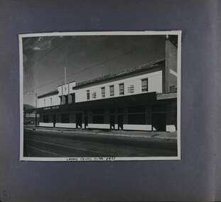
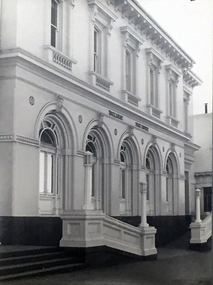
This photograph is part of the Caulfield Historical Album 1972. This album was created in approximately 1972 as part of a project by the Caulfield Historical Society to assist in identifying buildings worthy of preservation. The album is related to a Survey the Caulfield Historical Society developed in collaboration with the National Trust of Australia (Victoria) and Caulfield City Council to identify historic buildings within the City of Caulfield that warranted the protection of a National Trust Classification. Principal photographer thought to be Trevor Hart, member of Caulfield Historical Society. Most photographs were taken between 1966-1972 with a small number of photographs being older and from unknown sources. All photographs are black and white except where stated, with 386 photographs over 198 pages. Glen Eira Heritage Management Plan 1996 by Andrew Ward The 1857 rate book indicates that the major portion of the District was under pasture, although a considerable portion was cultivated. There were 159 houses, huts and tents whose occupants were mainly occupied on the land. If "Camden Town" was the principal commercial focus for the District in 1857, it was to remain so in later years, incorporated today in the Glenhuntly Road centre which extends more or less continuously from Elsternwick to Bambra Road. The Caulfield State School of 1877, the horse tramway of 1889 and subsequently the electric trams were all events confirming the importance of Glenhuntly Road and the fledgling community of "Camden Town" wherein the City's commercial centre has its origins. It is recalled, today, by their presence, and also by the "London Tavern" in Hawthorn Road, established by John Guess in 1873. Dr Geulah Solomon's 4 volume book "Caulfield's Heritage" Vol 1 p 93: "A modern hotel presently on the site continues the name of the London Tavern." That was true until recent years as the hotel is named The Camden Hotel now (2021).Page 81 of Photograph Album with one landscape photograph of the front of the London Tavern with handwriting on the edge of the photograph.Hand written: LONDON TAVERN HOTEL 1937 [on bottom edge of photo] / 81 [bottom left] trevor hart, caulfield, hawthorn road, london tavern, camden town, john guess, hotels, pubs, victorian, 1870's, 1930's, sycamore street, the camden hotel -
 Federation University Historical Collection
Photograph, William Holstead (thought to be), Ballarat from the Ballarat Town Hall Tower, c1940, 1935 - 1945
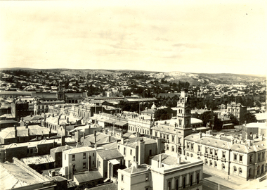
The original of this photo is in the Kicinski Family Private Collection. Their ancestor William Holstead was hall keeper at the Ballarat Town Hall, so it is though he took these photographs. Three scanned images of black and white photographs showing Ballarat as viewed from the Ballarat Town Hall. .1- Ballarat towards the Ballarat Post Office and Black Hill 2. Along Sturt Street Ballarat 3. Along Sturt Street and Bridge Street Ballarat looking towards Mt Warrenheip.ballarat, ballarat townscape, sturt street, black hill, tram, warrenheip. bridge street, holstead -
 Federation University Historical Collection
Photograph - Photograph - Black and White, Photographs of Ballarat Buildings by Geoff Biddington, 1967, 1967
Geoff Biddington took numerous photos around Ballarat and District. He was an active member of the Ballarat Branch of the National Trust. 48 black and white photographs of Ballarat buildings. 1. National Bank, Buninyong 2. Gas Light Standard, Geelong Road, Mount Clear 3. Water Hydrant 4. Former Police Station, Camp Street 5. Cast Iron Drinking Fountain, Eureka Stockade 6. Buninyong Gold Discovery Monument 7. Ballarat Old Cemetery Gates 8. Ballarat East Post office 9. Carriers Arms, Doveton Street North 10. North Star Hotel, Lydiard Street North 11.Lake View Hotel 12. Former Ballarat Gaol, Gate Two 13. Beaufort House 14. Smythesdale Post Office 15. Ballan Timber Building 16. National Mutual Building, Sturt Street 17. Craig's Hotel Doors 18. Her Majesty's Theatre Stage 19 & 20. Ballarat Botanical Gardens Statuary House 21 & 22. Stonemason at work 23. Methodist Church School (1867) Humffray Street 24 & 25. Methodist Church, Brown Hill 26. Queen St Statue,Sturt Street 27-29. Sturt Street Fountain 30. Moore Statue, Sturt Street 31. Hede Statue, Sturt Street 32. George V Statue (Victor Greenhalgh), Sturt Street 33-35. Peter Lalor Statue, Sturt Street 36. Art Deco Statue, Sturt Street 37. Beaufort Bandstand 38. Ranger Barracks, Curtis Street, Ballarat 39. Smeaton Mill and Bridge 40. Hepburn Graveyard, Smeaton 41-45 - Ballarat Tram Ride (possibly last) 46-48. Taking up the Ballarat Tram Tracks, 1967 .49. Melbourne House, Sebastopolgeoff biddington, biddington, buninyong, mount clear, police, gold, cemetery, hotels, ballarat gaol, beaufort house, smythesdale, ballan, theatre, statue, statues, statuary, peter lalor, ranger barracks, smeaton mill, smeaton bridge, hepburn, tram, sebastopol, craig's, her majesty's theatre, smeaton, hepburn graveyard, gold monument, queen victoria statue, ballarat, foodland, ballarat, ballarat buildings, former eagle hotel, former ballarat police station, gold discovery, craig's hotel, buninyong gold discovery obelisk -
 Federation University Historical Collection
Photograph, Ballarat photographs by Geoff Biddington, 1967, 1967
.6) Australian Catholic University Ballarat Campus (Aquinas) is set in the historic gardens of Carn Brea, formerly the property of Cornish miner Cyrus Retallack. The property includes a two-storey mansion, which he built as his family home in 1881. Carn Brea, a castle in Cornwall, was built in the 1500s. After the Queen's Church of England Girls' Grammar School acquired the property in 1919, the mansion was renamed Manifold House. Manifold House now accommodates administrative facilities of the campus and staff offices. (http://www.acu.edu.au/about_acu/campuses/ballarat/history_of_ballarat_campus, accesses 21 August 2014)Nine black and white images by Geoff Biddington. .1) Burke and Wills Monument, corner Sturt Street and Lydiard Street, with the MLS Building and Allan Brothers in the background. .2) Former Ballarat Post Office (later Federation University Post Office Gallery) .3) Tram in Sturt Street .4) Geelong ? shopping centre .5) Geelong Waterworks and Sewerage Trust .6) Carn Brae / Retallacks / Queen's / Australian Catholic University, 1200 Mair Street .7) Former Ballarat Post OFfice, Lydiard Street .8) Perseus Statue, Camp Street (removed for conservation in 2008) .9 McDonald Printer, 48 Lydiard Stgeoff biddington, ballarat, ballarat post office, geelong waterworks, perseus, mcdonald, acu, carn brae, australian catholic university ballarat, burk and wills monument, mlc building ballarat, allan brothers ballarat, lydiard street, sturt street -
 Bendigo Historical Society Inc.
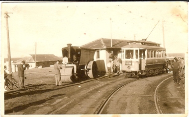
Photograph - BASIL MILLER COLLECTION: TRAMS
Black and white photograph of tram steam roller to left and building rear centre. Two men taking photos and person with bicycle left front. 3 young boys to left front of tram. 4 adults to right of tram. Inscription on reverse: in blue ink, 26/3/57(crossed with pencil), Last tram to Clovelly, (Old 'C'), 23/6/1957(in pencil). N.S.W. Tramway Historical Scty. Tramway steam roller nearby awaiting demolition on following day. Clayton Shuttleworth Roller(1 of 4).No. 216 written in pencil. A red mark just to left of centre and another red mark near photo top edge above other red mark.person, individual, basil miller -
 Bendigo Historical Society Inc.
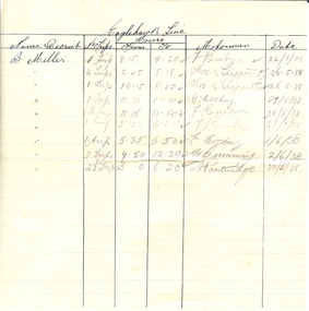
Document - BASIL MILLER COLLECTION: TRAMS - EXAM PASS - TIME TABLE
Envelope with notations on front referring to Basil Miller's Motorman's Examination written on front, May 1938. Time table of trips on Eaglehawk line.Inscriptions: bottom left corner. If not claimed in 7 days, return to: Bendigo Branch Electricity supply Department P.O. Box 166, Bendigo.ENE 1-3.person, individual, basil miller -
 Bendigo Historical Society Inc.
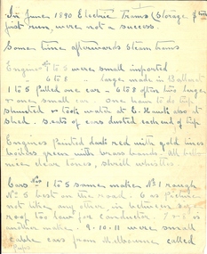
Document - BASIL MILLER COLLECTION: TRAMS - BRIEF HISTORY AND LIST OF NAMES
Three (3) hand written single sided pages giving a brief history of tramways and tram types that have run in Bendigo from June 1890. One (1) handwritten page naming people in a photograph, (not attached).person, individual, basil miller -
 Bendigo Historical Society Inc.
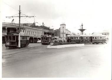
Photograph - BASIL MILLER COLLECTION: NUMBERS 21, 19, AND 1 OTHER TRAMS
... COLLECTION: NUMBERS 21, 19, AND 1 OTHER TRAMS. ...Black and white photograph of trams number 21, 19, and one other near Alexandra Fountain, Charing Cross. City Club Hotel, (left), and City Family hotel, (centre), visible in the background. Inscription on back of photo in pencil, '4X3' and '85#' in pen.person, individual, basil miller -
 Bendigo Historical Society Inc.
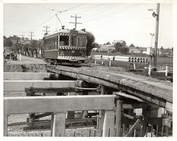
Photograph - BASIL MILLER COLLECTION: NO 30 TRAM
Black and white photo of No 30 Birney Car crossing the Nolan Street Bridge which is under going reconstruction. Vacant land on right of photo is now occupied by the Bendigo Tennis Complex..Written on back in pen '5 1/2'' x 5'' page 69 52.5 %'.person, individual, basil miller -
 Bendigo Historical Society Inc.
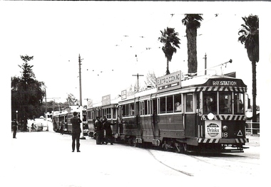
Photograph - BASIL MILLER COLLECTION: 4 TRAMS, EAGLEHAWK
Black and white photo of 4 trams, 3 bogie cars and 1 burnie safety car, stopped on Sailors Gully Road near Canterbury Park. No 18 Tram in lead, destined for Railway Station.person, individual, basil miller -
 Bendigo Historical Society Inc.
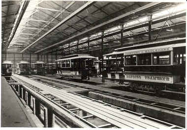
Photograph - BASIL MILLER COLLECTION: 6 TRAMS
Black and white photo of 6 trams in shed at depot. On back of photo 'Photo A Doney Bendigo' stamped in purple, handwritten 'Same size about 5 1/2' x 8 1/2 Page 70 100% P 6'.person, individual, basil miller -
 Bendigo Historical Society Inc.
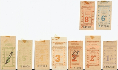
Document - BASIL MILLER COLLECTION: TRAMS - TICKETS
Nine loose tickets. Page dates October 19 - 65. Tickets 2d. - city section, 2d., 3d., 5d concession, 5d., 4d., 8d., 1 shilling (page A). Tickets 3d. - city section, 10d., two 6d. Parcel tickets (B). All issued by State Electricity Commission of Victoria Provincial Tramways.person, individual, basil miller