Showing 1383 items
matching bushfire
-
 Eltham District Historical Society Inc
Photograph - Digital Photograph, Marguerite Marshall, Stuchbery Farm dairy, 14 March 2008
Stuchbery Farm was situated on the Plenty River bounded by Smugglers Gully to the north and La trobe Road, Yarrambat, to the east. Alan and Ada Stutchbery moved to the valley in 1890, first living in a tent where four children were born. Alfred built a home and outbuildings around 1896. They planted an orchard, then a market garden and developed a dairy. Published: Nillumbik Now and Then / Marguerite Marshall 2008; photographs Alan King with Marguerite Marshall.; p179 The dramatic steep-sided Plenty Gorge lies along the divide of two geological areas, and separates the Nillumbik Shire and the City of Whittlesea. On the Nillumbik side are undulating hills and sedimentary rock, and in Whittlesea, lies a basalt plain formed by volcanic action up to two million years ago. This provides the Plenty Gorge Park with diverse vegetation and habitats, making it one of Greater Melbourne’s most important refuges for threatened and significant species. The park, established in 1986, consists of around 1350 hectares, and extends 11 kilometres along the Plenty River, from Greensborough to Mernda. It provides a wildlife corridor for around 500 native plant and 280 animal species. The area’s plentiful food and water attracted the Wurundjeri Aboriginal people and then European settlers. By 1837 squatters had claimed large runs of land for their sheep and cattle. The Plenty Valley was among the first in the Port Phillip District to be settled - mainly in the less heavily timbered west - and was proclaimed a settled district in 1841. But by the late 1880s, the settlers’ extensive land clearing for animal grazing, then agriculture, depleted the Wurundjeri’s traditional food sources, which helped to drive them away. Many Wurundjeri artefacts remain (now government protected), and so far 57 sites have been identified in the park, including scarred trees, burial areas and stone artefacts. Pioneer life could be very hard because of isolation, flooding, bushfires and bushrangers. Following the Black Thursday bushfires of 1851, basalt was quarried to build more fire-resistant homes. Gold discoveries in the early 1850s swelled the population, particularly around Smugglers Gully; but food production made more of an impact. In the late 1850s wheat production supplanted grazing. In the 1860s the government made small holdings available to poorer settlers. These had the greatest effect on the district, particularly in Doreen and Yarrambat, where orchards were established from the 1880s to 1914. Links with a prominent early family are the remains of Stuchbery Farm, by the river’s edge bounded by Smugglers Gully to the north and La Trobe Road, Yarrambat, to the east. The Stuchberys moved to the valley in 1890, and the family still lives in the area. In 1890, Alfred and Ada first lived in a tent where four children were born, then Alfred built the house and outbuildings around 1896. They planted an orchard, then a market garden, and developed a dairy. The family belonged to the local Methodist and tennis communities. Their grandson Walter, opened the Flying Scotsman Model Railway Museum in Yarrambat, which his widow, Vi, continues to run. Wal was also the Yarrambat CFA Captain for 22 years until 1987. Walter sold 24 hectares in 1976 for development - now Vista Court - and in 1990, the remaining 22.6 hectares for the park. Remaining are an early stone dairy and remnants of a stone barn, a pig sty and a well. Until it was destroyed by fire in 2003, a slab hut stood on the Happy Hollow Farm site, at the southern end of the park. The hut is thought to have been built in the Depression around 1893. This was a rare and late example of a slab hut with a domestic orchard close to Melbourne. Emmet Watmough and his family first occupied the hut, followed by a succession of families, until the Bell family bought it around 1948. There they led a subsistence lifestyle for 50 years, despite encroaching Melbourne suburbia. The Yellow Gum Recreation Area includes the Blue Lake, coloured turquoise at certain times of the year. Following the 1957 bushfires, this area was quarried by Reid Quarries Pty Ltd for Melbourne’s first skyscrapers, then by Boral Australia. However in the early 1970s water began seeping into the quarry forming the Blue Lake and the quarry was closed. The State Government bought the site in 1997 and opened it as a park in 1999.This collection of almost 130 photos about places and people within the Shire of Nillumbik, an urban and rural municipality in Melbourne's north, contributes to an understanding of the history of the Shire. Published in 2008 immediately prior to the Black Saturday bushfires of February 7, 2009, it documents sites that were impacted, and in some cases destroyed by the fires. It includes photographs taken especially for the publication, creating a unique time capsule representing the Shire in the early 21st century. It remains the most recent comprehenesive publication devoted to the Shire's history connecting local residents to the past. nillumbik now and then (marshall-king) collection, ada stuchbery, alan stuchbery, dairy, stuchbery farm, farm buildings, yarrambat, plenty gorge park -
 Department of Energy, Environment and Climate Action
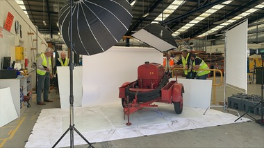
Altona Collection Photography and Cataloguing - November 2024
In November 2024, a small group of cheerful volunteers from the Forests Commission Retired Personnel Association (FCRPA) toiled over nine days to dust-off, photograph and record nearly 300 artifacts in DEECA's Altona Museum. It followed a similar project at the FCRPA's Beechworth Museum in February 2024. The Altona project was generously supported by DEECA / FFMVic to engage professional photographer Mark Jesser from Wodonga whose boundless energy and good humour helped to create these amazing images. Special thanks go to the FFMVic Chief Fire Officer, Chris Hardman, as well as Andrew Stanios and Kat Jensen for making it happen. FFMVic crews and the ever-patient staff from Altona took a strong interest and also helped to shift some of the heavy items like pumps and the Bedford tanker which was very welcome. The Forests Commission and its successors continuously encouraged bushfire research and innovation. In 1946 a large parcel of industrial land was purchased at North Altona as a fire cache and workshop. The Altona workshop became a hotbed of new technological thingumajigs… a marvellous blend of Aladdin’s Cave of Wonders coupled with Wallace and Gromit’s madcap contraptions… an exhilarating place where lots of gizmos were invented and tested… mostly with astounding results... but nearly always with some head-scratching frustrations… and thankfully not too much explosive mayhem. In fact, a lot of Australia’s pioneering equipment development was led by staff from Altona, often in collaboration with other State forestry and fire authorities. The CSIRO also contributed significantly. The US Forest Service, the US Bureau of Land Management and US State agencies such as the California Department of Forestry and Fire (CalFire) as well as the Canadian Forest Service faced similar challenges and proved strong and willing partners in sharing knowledge, ideas, equipment and expertise over many decades. The collection at Altona started in the 1970s by fire equipment wizard Barry (Rocky) Marsden. As obsolete equipment was returned to the Fire Protection Workshop for auction, Rocky began the process of selecting some which would be interesting to retain and display. The items at Altona represent just a small sample of the amazing story of Victoria's forestry and bushfire heritage. The largest item was undoubtedly the Bedford tanker which took two days and nearly 1000 photos which were later stitched together with photoshop. The oldest item is probably the Ericsson wall telephone from 1904. There are also many unique items, but the CSIRO incendiary machine and ping-pong incendiary machine developed at Altona probably had the most significant impact on fire management in Australia. There are plenty of gaps in the collection, but some items are in regional DEECA offices. It’s hoped to merge the FCRPA's Beechworth collection to Altona one day and rename the site to honour Rocky Marsden. There may be some additions to the Altona museum over time, but space is limited. The museum is available to visit by appointment. Peter McHugh - January 2025 forests commission victoria (fcv) -
 Eltham District Historical Society Inc
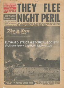
Newspaper - Newspaper articles, Sun News-Pictorial, They Flee Night Peril, The Sun News-Pictorial, Wednesday, January 17, p1, 1962
Various news articles pertaining to the January 1962 Victorian bushfires in the Dandenong and Healesville districts which by the third day had encompassed large areas of the State. Specific Eltham Shire districts mentioned include Panton Hill and Hurstbridge on page 1, Warrandyte on page 2, 3, 4 and 5, Hurstbridge, Smith’s Gully, Kinglake on page 3 and 4, Strathewen, Kangaroo Ground, Panton Hill, St. Andrews, Smith’s Gully on page 4 and Pound Bend, Smith’s Gully and Warrandyte on pages 20-21 • They Flee Night Peril, p1 (Illust.) • Their grim picnic; A flash fire strikes, p2 (Illust.) • Night of terror as towns quitted, p3 • Fought till he dropped, p3 (Illust.) • Rain in fire area, p3 • Wye River town goes, p3 • Black Friday Hero Dies In Fire; with wife, grandsons, p4 • Surrounded!, p4 (Illust.) • Main street houses ablaze, p4 • Hurstbridge is evacuated, p4 • Scores jump in river at Warrandyte, p5 • Hills people leave homes, p5 • “Fire” cry at Parlt., p5 • Blind – he’s safe now, p5 (Illust.) • Police Chief Runs Battle, p7 • From Fire Front: Hospital treats 34, p7 • Firms send help, p7 • Tragedy and Ruin: Third Day; Ferntree Gully; Warrandyte; Pound Bend; Smiths Gully; Escape for 18, pp20-21 (Illust.) • Church was a haven for the hurt, weary, p39 (Illust.) • A home is lost, p40 (Illust.) tom fielding collection, victorian bushfires - 1962, victorian bushfires – 1962, panton hill, hurstbridge, five ways crossroads, warrandyte south, dandenongs, upwey, mt. evelyn, monbulk, olinda, sassafras, st. andrews, warrandyte, christmas hills, yarra river, mitcham, whitehorse roiad, donvale, park orchards, metropolitan fire chief, w.t. aldridge, loughnan’s hill, ringwood, woori yallock, leslie ockwell, linda ockwell, kalorama, healesville, daylesford, fire damage – buildings, wye river, portland, eganstown, ballarat, sherbrooke park forest, forest commission headquarters, kallista, r.t. seaton, montrose, yallourn, central gippsland, smith’s creek, black friday, geoffrey ockwell, ronald ockwell, preston town hall, e.j. tenner, strathewen, kangaroo ground, eric farnsworth, adele farnsworth, robin farnsworth, roy cleland, ann cleland, belgrave, sassfras, kaloramalice commissioner porter, mansfield, box hill hospital, pound bend, ferntree gully, ferntree gully state school, w. carew, ann quinton -
 Forests Commission Retired Personnel Association (FCRPA)
Beechworth FCV District office sign
This sign proudly hung outside the Forests Commission Victoria (FCV) Beechworth office which is now site of the Forestry Heritage Museum. The granite building in the Beechworth's historic precinct was once the Gold Warden's Office and is one of the town's original buildings. The FCV was the main government authority responsible for management and protection of State forests in Victoria between 1918 and 1983. The Commission was responsible for ″forest policy, prevention and suppression of bushfires, issuing leases and licences, planting and thinning of forests, the development of plantations, reforestation, nurseries, forestry education, the development of commercial timber harvesting and marketing of produce, building and maintaining forest roads, provision of recreation facilities, protection of water, soils and wildlife, forest research and making recommendations on the acquisition or alienation of land for forest purposes″. The Forests Commission had a long and proud history of innovation and of managing Victoria's State forests but in September 1983 lost its discrete identity when it was merged into the newly formed Victorian Department of Conservation, Forests and Lands (CFL) along with the Crown Lands and Survey Department, National Park Service, Soil Conservation Authority and Fisheries and Wildlife Service. After the amalgamation the management of State forests and the forestry profession continued but the tempo of change accelerated, with many more departmental restructures occurring over the subsequent four decades. Responsibilities are currently split between the Department of Energy, Environment and Climate Action (DEECA), Forests Fire Management Victoria (FFMV), Parks Victoria, Melbourne Water, Alpine Resorts Commission, the State Government-owned commercial entity VicForests and the privately owned Hancock Victorian Plantations (HVP).Large office sign. Hand painted in traditional FCV mission brown and gold colour scheme.forests commission victoria (fcv), forest signs -
 Eltham District Historical Society Inc
Photograph - Digital Photograph, Marguerite Marshall, Strathewen Public Hall, 20 August 2008
Strathewen Public Hall, social and spiritual centre was later lost in the Black Saturday fires 2009. The Strathewen Community decided a community hall was needed in 1901. In 1902 locals built the hall with messmate trees. It was located on the Cottlesbridge-Strathewen Road. The first function was a Grand concert and Balll attended by about 120 people. Several denominations held Church services and Sunday School services in the Hall. It survived several bushfires until after this photo was taken when it was destroyed in Black Saturday, 9 February 2009. Published: Nillumbik Now and Then / Marguerite Marshall 2008; photographs Alan King with Marguerite Marshall.; p89 Strathewen was settled late, largely because it was difficult to access.1 Early selectors found it a struggle to survive. They had to do everything themselves, from felling trees for buildings, to taking produce to market along bush tracks that they had helped cut. Small dairy farms were typical but fruit became the district’s prime produce. The first settlers east of Arthurs Creek were brothers John and Duncan Smith whose station Glen-Ard was probably operated as a sheep run. Other early settlers were the Mann family, who were to donate land for the hall, provide postal services and John Mann was an Eltham Shire councillor from 1916 to 1919.2 In 1873 James Mann, his wife Jane and their six children, settled on 207 acres (83.7) (Lang Fauld Farm) on both sides of Eagles Nest Road, from the foot of Mount Sugarloaf to the bank of the Arthurs Creek. In 1883 James took up another selection on Chads Creek. It was very hard work and at times he was well behind with his rent. However the family had a good social life, attending the Primitive Methodist Church at the Arthurs Creek Township and on New Year’s Eve throwing a party for all the locals. By 1874 James Mann’s younger brother, John, selected 311 acres (125.8ha) between Eagles Nest Road and upper Arthurs Creek. He called it Carseburn after his home parish in Scotland. Tragically in 1875 John drowned in the Yarra River, at Richmond.3 John Mann’s oldest son, also John, later purchased Duncan Smith’s land, which he named Violet Glen. He was to give one acre (0.4ha) of this land for the Strathewen Hall site. A Mann family diary written at Carseburn in 1897, tells how the district’s name was selected. Strathewen is derived from ‘strath’ meaning ‘broad mountain valley’ and from the name of Ewen H. Cameron, the local parliamentarian for almost 40 years. ‘George Brain came around to get a petition signed to get a post office up here and we had to vote for a name—Strathewen, Glen-Ard, or Headcorie’.4 It was at Carseburn that a public meeting in 1901, decided to build the Strathewen Hall on the Cottlesbridge-Strathewen Road. In 1902 the locals built the hall with messmate trees. The first function was a Grand Concert and Ball attended by around 120 people and several Protestant denominations took turns to hold church services and Sunday School there. Fortunately the hall has survived bushfires to be the town’s spiritual and social centre.5 The area continued to develop and in 1909 a post office operated somewhere at Strathewen and from around 1916 at Carseburn.6 It was not until 1914 that land was bought to establish the Strathewen State School on School Ridge Road. The residents paid £100 to build it on two acres (0.8 ha) while the Education Department contributed £30 and leased the building annually for £1. When teacher Miss Mary Golding opened the school in 1917, it had no equipment.7 But in 1921 the Education Department provided desks and a hexagonal shelter shed (now a rare style in Victoria) and took control in 1925.8 By 1917 Strathewen was booming.9 George Apted had built a coolstore in 1916, and local orchardists bought storage space until the 1950s. This allowed the area to supply the market in and out of season. Guesthouses catered for growing tourism. In the mid 1920s Mrs Eleanor Sparkes built the guest-house Singing Waters, which operated through the 1930s. Her daughter Mrs Vera McKimmie, ran it until the 1950s and the house remains in Chads Creek Road. In the Great Depression land was cleared for timber to be sold as firewood and there was small scale sawmilling. However the orchard industry diminished for several reasons including the 1939 bushfires and rapid changes in production methods. Today the Apteds still operate an orchard and farm at Glen-Ard, which straddles the border between Strathewen and Arthurs Creek. It includes the southern part of Duncan Smith’s original Glen-Ard selection.This collection of almost 130 photos about places and people within the Shire of Nillumbik, an urban and rural municipality in Melbourne's north, contributes to an understanding of the history of the Shire. Published in 2008 immediately prior to the Black Saturday bushfires of February 7, 2009, it documents sites that were impacted, and in some cases destroyed by the fires. It includes photographs taken especially for the publication, creating a unique time capsule representing the Shire in the early 21st century. It remains the most recent comprehenesive publication devoted to the Shire's history connecting local residents to the past. nillumbik now and then (marshall-king) collection, strathewan public hall -
 Kiewa Valley Historical Society
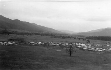
Photographs x 2 - 1. Mt Beauty Camp 2. Bogong Camp, Photo 1 - September 1950
Mt Beauty Camp- The new State Electricity Commission construction camp at the head of the Kiewa Valley was for workmen on the second power station in the project expected to be the most modern and best equipped in Australia… In contrast to the early Kiewa days of horses and canvas tents, the new camp, with its modern amenities, compared favourably with any country town. Administration of the Kiewa Scheme was moved from Tawonga to Mount Beauty in 1946. The first house in Mount Beauty, in Hollonds Street, was occupied by the co-op store manager from November 1946. The new Mess Hall at Mt Beauty was opened with much ceremony in early November 1946. The houses up to Nelse street were erected from 1946 onward and then the township was extended beyond Nelse Street in 1950. The workmen's camp was enlarged in 1950 to the extent of providing accommodation for a total of 1,200. Bogong Camp - In 1940 Field Headquarters for the Kiewa Scheme were established at Bogong with office, workshop facilities and accommodation for workmen, staff and some families constructed. (There had been a 'tent camp' on this site in 1939 but was destroyed by bushfires) Construction of accommodation continued until 1947. A total of 40 houses plus a hostel for single staff, post office, police station, medical centre and primary school all with water and sewerage and electricity supply. The staff hostel was known as Kiewa House and is now occupied by the Education Department. Lake Guy was named after Mr. L.T. Guy who was the Resident Engineer in charge of construction work and associated activities on the Kiewa area. He held this position from 1939 to November 1946 when he was transferred to Head Office. Both Bogong Village and Mt Beauty were developed to accommodate workmen on the Kiewa Hydro Electric Scheme but have since become centres for tourism and a range of outdoor activities.1. Black and white photograph of Mount Beauty Camp taken in September 1950 2. Black and white photograph of Bogong Village Camp1. Written on the back in grey lead - Sept 1950. Mt Beauty Camp. HT Cooper own taking 2. Stamped on back of photograph - Copyright. Not for reproduction. Herald Sun feature Service. Melbourne Australiamt beauty camp, bogong camp, secv -
 Eltham District Historical Society Inc
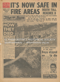
Newspaper - Newspaper articles, Sun News-Pictorial, It's Now Safe in Fire Areas; Death Toll Reacxhes 8, The Sun News-Pictorial, Thursday, January 18, p1, 1962
Various news articles pertaining to the January 1962 Victorian bushfires in the Dandenong and Healesville districts which by the third day had encompassed large areas of the State. Specific Eltham Shire districts mentioned include Warrandyte on page 1, St. Andrews and Smith’s Gully on page 2, St. Andrews on page 3 and 43, Panton Hill and Warrandyte on p23 and Hurstbridge on page 44 • It's Now Safe in Fire Areas; Death Toll Reaches 8, p1 (Illust.) • How they died, pp1-2 • It was “heaven” in the bush … Boys stayed on . . . to die, pp1-2 (Illust.) • Towns take stock as danger drops, p2 • £5400 to the relief fund, p2 • Fire now threat to Otways, p2 • Pensioners lose all, p2 • “…If Only The Rain Had Come” … and then it came to town, p3 (Illust.) • Our best rain since May • It halted at Grandma’s front gate, p5 (Illust.) • Now that the rain has come; It’s time for the clean-up, p6 • Wisps of smoke where flames danced, p7 • Charitry’s a loser, p7 • War Service homes claim, p7 • Help’s on way, p7 (Illust.) • Came with their gifts …, p7 • Fire summons for youth; “sparked the rest”, p9 • Three gaoled, p9 • They had to camp out at Wye River, p9 (Illust.) • “Probe Fires” – Stoneham, p9 • The Fourth Day: Scorched Earth!, pp22-23 (Illust.) • This home was saved but - , p22 (Illust.) • Relief Centre, p23 (Illust.) • Homeless, p23 (Illust.) • So little was left, p43 (Illust.) • Tommy saved his cat, p43 (Illust.) • Some were lucky … and some were tired, p44 (Illust.) tom fielding collection, victorian bushfires - 1962, victorian bushfires – 1962, ronald ockwell, geoffrey ockwell, woori yallock, william ockwell, leslie ockwell, linda may ockwell, black friday, victorian bushfires – 1939, warrandyte, arthur brown, harold vernon betton, bloom road, william smith, olinda, bushfire relief fund, yarra glen, healesville, railway line, st. andrews, smith’s gully, otway ranges, eric watts, edith varty, inverness road, mt. evelyn, wye river, panton hil, heather sullivan, warrandyte hall, montrose, kalorama, mrs e. tucker, shirley tucker, margaret tucker, joane tucker, roger tucker, trevor tucker, ann quinton, tom dunstan, hurstbridge hall -
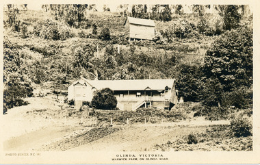 Mt Dandenong & District Historical Society Inc.
Photograph, Warwick Farm On Olinda Road
Information supplied by Stephen Trembath. Warwick Farm was established by my late grand parents Polly (nee Mary Ann Cole) and George Barratt and their 5 children George Jnr, William, James, John (my maternal Grand Father) and Teddy. Their story is told in a book "The wine of Courage" written in 1977 by N.M. Roberts ISBN 0 7223 1003. Their story started when their bank closed their doors on 13 April 1893 and they lost their cafe business in South Melbourne. Two days later, they were ready to head for a new start in Queensland when they saw in the morning paper that the Dandenong Ranges had been thrown open to land release to people. A few days later, having been granted land they headed to Ferntree Gully. From there they walked to the new holding in what would become Olinda. Then George with his sons help had to build a shelter for the family for the night. They chose to name the property "Warwick Farm". Work on the house started a few days later with help from neighbours Mr. Dodd, Mr Beattie, the O'Sheas and others. Come November, Ruby was born. Then bushfire burnt down the newly built house. Back to a bark hut until another house could be built. The new house became a guest house at the suggestion of a neighbour, when George couldn't sell timber and was waiting for crops. The first guests visited in 1898 and another baby, Percival, was born. ....................................................... It was George's son Jim, who was a skilled carpenter and axeman who extended the home to take from 12 to 30 guests. In 1950 Warwick Farm became the home of distinguished writer and journalist C.E.Sayers for a number of years.Photo Series Pictorial Postcard # 981 showing the property Warwick Farm on Olinda Road.Printed on back: PHOTO SERIES Pictorial Postcards. Published by S. Jamieson Bros. Alphington Vic. Phone Northcote 60warwick farm, olinda, postcard, photo series, olinda road, george barratt, barratt, guest house, guest house -
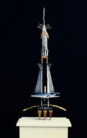 Federation University Art Collection
Sculpture, Thomas, Kylie, 'Cultural Dedication' by Kylie Thomas, 1993
Kylie THOMAS (14 May 1973 - ) Born Creswick, Victoria A graduate of the Bachelor of Arts (Visual Arts) (1993) and Diploma of Visual Arts (1995) from Federation University (then University of Ballarat) Kylie Thomas continued her art practice after studying under distinguished sculptors Peter Blizzard and Adrian Mauriks. This work was acquired from her graduate folio. Soon after completing her studies Kylie Thomas became an artist in residence at Ballarat Grammar School building a public sculpture for the grounds conceived by one of her selected students as part of the program. She became the youngest exhibiting applicant to be awarded the City of Port Phillip, Rupert Bunny Foundation artist in residence program. After moving to Mallacoota she was absorbed into the community as a visual artist, actor, playwright and assistant publicist. Her commissioned public artwork and sculptures as part of residences collections were all lost in the 2019 bushfires that decimated Mallacoota. Moving back to her hometown of Creswick Kylie Thomas completed a Diploma in Education qualifying as a secondary teacher, always continuing her art practice while teaching. Needing to work again, but with no desire to teach, Kylie Thomas studied Building Design and Architectural Drafting, homing in on other areas which could link back to her artistic practice. Working in this field for a short time she moved to Melbourne where she exhibited paintings and sculpture installations as part of The Melbourne Fringe Festival. She also worked in set design, and as a stage manager and theatre actor. This item is part of the Federation University Art Collection. The Art Collection features over 2000 works and was listed as a 'Ballarat Treasure' in 2007.This work is a spiritual totem created in the tradition of the bricoleur, dedicated to bygone cultures, lost technology and mystery referencing nature, humanity and technology. Humanity to use technology with and for nature. The materials are symbolic, the use of bone, Perspex, computer parts, found and crafted objects constructed in a resulting harmony creating a symbiotic relationship. Tapping the 4th dimension that could lift off into space and come back again, with a feeling of weightlessness, awe and suspension captured. A sculpture which stands on a white pedestal with perspex cover. 'Cultural Dedication' is the final work in a series of sculptures influenced by the ancient cultures of Egypt. art, artwork, kylie thomas, sculpture, alumni -
 Eltham District Historical Society Inc
Document - Folder, Pugh, Clifton
The artist, Clifton Pugh, grew up in Briar Hill. He served in WWII and settled at Cottles Bridge, building his own house and forming Dunmoochin artist colony. He married three times and had two sons. He painted the portraits of many eminent people. Contents Newspaper article: "This is the house that Cliff built", The Age, 2 May 1964. Description of Clifton and Marlene Pugh's house.. Folder: Brief biography Clifton Pugh. Photocopy section of "Clifton Pugh: Patterns of a lifetime", Traudi Allen, Nelson, Melbourne 1981. Magazine article: "Clifton Pugh: His home is a work of art", Woman's Day, 16 January 1894. Describes Clifton Pugh's house at Hurstbridge. Newspaper article: "A guide to our orchids", Diamond Valley News, 14 February 1984. Clifton Pugh contributed to the book "A Year of Orchids". Newspaper article: "A family tradition is continued". Diamond Valley News, 28 February 1984. Clifton Pugh's childhood and career. Magazine article: "Clifton Pugh's bush paradise", Home Beautiful, May 1989. Clifton Pugh's house and studio. Clipping: "Clifton Pugh award winning artist". Clifton Pugh currently working on illustrations for a book, with Pam Blashki, on wood chipping ["A Kingdom Lost: A Story of the Devastation of Our Wilderness", published 1989]. Newspaper article: "Funeral drama shows the Pugh touch", The Age, 19 October 1990. Clifton Pugh's funeral at Montsalvat. Newspaper article: "Friends bid farewell to Pugh". Herald-Sun, 19 October 1990. Clifton Pugh's funeral at Montsalvat. Newspaper article: "Friends paint a lowing portrait". Herald-Sun, 19 October 1990. Funeral and obituary of Clifton Pugh. Newspaper article: "Montsalvat mourns passing of a great". Diamond Valley News, 23 October 1990. Clifton Pugh's funeral at Montsalvat. Newspaper article: "Loner who was a fair dinkum mate". Diamond Valley News, 23 October 1990. Obituary of Clifton Pugh. Newspaper article: "Pugh's last works", Tempo, The Age, 17 July 1991. Clifton Pugh was illustrating Helen Lunn's book 'The Digger's Mate' when he died. Newspaper article: "Dunmoochin's rich tradition to live on", Diamond Valley News, 29 October 1993. Dunmoochin Foundation Board to advertise lease of studios. Newspaper article: "Clean up for Cliff", Herald Sun, 8 December 1993. Preparation for exhibition of Clifton Pugh's work at LaTrobe University Art Museum. Flier: Exhibition "Clifton Pugh: A Retrospective", Montsalvat, 12 to 14 November 1999. Newsletter: "Dunmoochin: an edited version of the history prepared for the Heritage Study by David Bick", Eltham District Historical Society newsletter 140, September 2001 Newspaper article: "Hail rising of Phoenix", Diamond Valley Leader, 20 July 2005. Dunmoochin Foundation and official opening of buildings Phoenix I and Phoenix II after the 2001 bush fire. Newspaper article: "Legacy to the arts", Diamond Valley Leader, 10 August 2005. Dunmoochin Foundation and the rebuilding after the 2001 bush fire. Newspaper article: "Tiwi art to go on show", ?publication, ?2002. Shane Pugh, Johnny Young and Ian McKimmie organising exhibition of Tiwi art to mark 100th birthday of Strathewen hall. Flier: Exhibition "Clifton Pugh AO: Reflections of Dunmoochin". Briar Hill Primary School, 23 to 25 November 2007. Printout: "Dunmoochin", http://www.standrews.vic.edu.au/dunmoochin.html. 19 May 2004. Newspaper article: "Hail rising of Phoenix", Diamond Valley Leader, 20 July 2005. Rebuilding at Dunmoochin after bushfire. Newspaper article: "Legacy to the arts", Diamond Valley Leader, 10 August 2005. Rebuilding at Dunmoochin after bushfire. Newspaper article: "Artist's legacy on show". Dunmoochin one of four Cottles Bridge sites for a tour by Trust for Nature, 2 and 3 October no year. Newspaper clippings, A4 photocopies, etcclifton pugh, hurstbridge, adriane strampp, princess michael of kent, arthur boyd, john brack, charles blackman, fred williams, shane pugh, marlene pugh, professor jock marshall, briar hill victoria, cottles bridge victoria, turner family of briar hill, yandell family of briar hill, st helena church, st helena road, briar hill primary school, eltham high school, dunmoochin, campbell beardsell, david beardsell, ivanhoe boys grammar school, national gallery art school, hurstbridge grevillea, montsalvat, george dreyfus, kew city band, justus jorgensen, sir edward "weary" dunlop, prue acton, john howley, fay dunmore singers, derryn hinch, jeff kennett, tom uren, dennis gowing, matcham skipper, kyra skipper, gordon ford, hilary jackman, peter graham, robert marshall, john greaves, jenni mitchell, rodney roschollor, gough whitlam, sir john kerr, lionel murphy, manning clark, arts policy committee of victorian branch of the australian labor party, latrobe's art museum, rudy komon gallery, leonard french, jon molvig, rick armor, john olsen, latrobe university, donovan pugh, trevor welshman, australia council visual arts board, lesley alway, dailan pugh, paul barnett, helen nixon, helen lunn, a year of orchids book, campbell bearsdell, david bearsdell, johnny young, ian mckimmie, tiwi art, strathewen hall, rhonda noble, latrobe university art museum, traudi allen, clifton pugh patterns of a lifetime book, trust for nature, randall robinson -
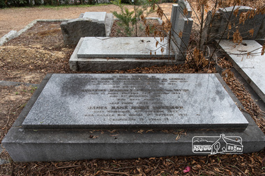 Eltham District Historical Society Inc
Photograph, Peter Pidgeon, Grave of James Hans Morrison and Beatrice Wanliis Morrison, Eltham Cemetery, Victoria, 5 April 2021
Beatrice Irvine was the daughter of former Victorian Premier Sir William Irvine. From age 13 she lived at ‘Killeavey’ off Laughing Waters Road (later accessed from Reynolds Road). In 1923 she married James Morrison and the couple received Killeavey as a wedding gift. The property supported fruit and vegetable growing as well as an impressive botanical garden. But James died in 1936 after a period of ill health, leaving Beatrice to support their six children. To make matters worse, the house was totally destroyed in the Black Friday bushfires in 1939 but was rebuilt. Beatrice became involved in community issues. In particular, she was an active member of the Eltham Women's Auxiliary, which was formed in 1945 to raise funds for the establishment of an Eltham War Memorial. From the outset, it was decided that this would take the form of a Baby Health Centre, a Pre-School and a Children’s Library, set in a garden of remembrance. Thanks to tireless fund-raising, the project came to fruition in the 1950s when, one by one, the three children's welfare buildings opened in Main Road (having previously been in temporary premises): they are collectively known as the Eltham War Memorial site. Beatrice continued to live at Killeavey and became well regarded as a botanist and naturalist. She died in 1989 and is buried in Eltham Cemetery with her husband and one of their sons. The (rebuilt) house has since been demolished. All that remains is a fragment of the garden. In Fond Memory Of James Hans Morrison Croix de Guerre Born St Peters Pass Oatlands Tasmania 6th June 1880 Died Killeavey Eltham 16th November 1936 And his beloved wife Beatrice Wanliss Morrison (nee) Irvine Born St Kilda Victoria 22nd January 1899 Died 5th November 1989 Who rest here James Hans Irvine Morrison Born Melbourne 11th October 1927 Died Gorora New Guinea 1st October 1971Born Digitaleltham cemetery, gravestones, beatrice wanliss morrison (nee irvine), james hans irvine morrison, james hans morrison, croix de guerre (france) -
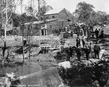 Eltham District Historical Society Inc
Negative - Photograph, Opening of St. Andrews Battery, Queenstown, 29 Aug. 1919
Reproduced on p31 of 'Pioneers & Painters' Was destroyed in 1962 bushfire. Now Peter Franks Reserve, St Andrews On Friday 29th (August 1919) …, the Hon. S. Barnes, M. L. A., Minister of Mines, accompanied by Mr W. Everard, M.L.A., Mr. V. Dickson, secretary for Mines, and Mr. Merrin, Chief Mining Inspector, visited Smith's Gully for the purpose of opening, the new Government battery which has recently been erected. The party arrived punctually at 12.30, and was received by an assemblage of about 200 residents, including, those representing local prospecting and mining interests. At the mill house the Minister wished prosperity to mining on the old Queenstown field, and, in a few appropriate remarks, gave the battery the name of St. Andrew's. Then, as the stamps began to fall, three hearty cheers were given by the gathering. ….. The Queenstown field, dating back to the early sixties, might be regarded as a link that took them back to the Augustine age of gold mining in Victoria…From 1868 to 1918 the total yield of gold from the field was 274,606 fine oz. It might be that here, as elsewhere, deeper prospecting would give new life to the Queenstown goldfield. The miners of Queenstown, who through long year's had never lost faith in the possibilities of the field, felt that the purpose for which they were that day marked the beginning of a new era in the history of local reefing. …. The new mill is situated on the bank of the creek opposite the Queenstown Cemetery, and consists of a five head battery (Berdan pan) and 12 h.p. portable steam engine housed in a spacious structure of wood and iron. A concrete weir across the creek provides a good water supply, and all the necessary pumps, settling dams, etc., have been installed. Later on, should circumstances warrant it, it is pro-posed to erect Wilfley tables for concentrates. Eltham and Whittlesea Shires Advertiser and Diamond Creek Valley Advocate, Friday 5 September 1919, page 3This photo forms part of a collection of photographs gathered by the Shire of Eltham for their centenary project book,"Pioneers and Painters: 100 years of the Shire of Eltham" by Alan Marshall (1971). The collection of over 500 images is held in partnership between Eltham District Historical Society and Yarra Plenty Regional Library (Eltham Library) and is now formally known as the 'The Shire of Eltham Pioneers Photograph Collection.' It is significant in being the first community sourced collection representing the places and people of the Shire's first one hundred years.Digital image 4 x 5 inch B&W Neg Print 20 x 25 (2)shire of eltham pioneers photograph collection, queenstown, st andrews, st. andrews battery, gold mining, s. barnes, merrin, st andrews battery, v. dickson, william h. everard, peter franks reserve -
 Bendigo Historical Society Inc.
Photograph - Historical Society Field Trip to the Springs at Sedgwick, Abt 2009
The Phil Wilkin Collection contains a series of 11 Items. The related items can be found by clicking on the reference link below. The following history of the Young family and their descendants who lived at the Springs is provided by Phil Wilkin. His Great Grandparents were Frances Young and August Wirth. Phil has also provided notes on the Wilkin Family and some history of the gold mining in Sedgwick. Frances Young's parents Joseph and Margaret Young owned the property called "The Old Place, Preston Vale or Wellington Flat" at Sedgwick near the Springs. Joseph Young owned and Managed the Standard Brewery which was located at Campbells Creek during the late 1800’s early 1900’s. Joseph and Margaret are buried in the Harcourt cemetery. In 1880 August Wirth lived at Mosquito Creek (Lake Eppalock, Victoria) when he married Frances Young. In 1902 they moved to part of Joseph Young's property. They milked cows and sold cattle for a living. One of their children Charles Wirth (Phil Wilkin's Grandfather) bought the land in 1935 after his parents had died. Charles Wirth was a councillor and also was president of the Shire of Strathfieldsaye. The "Old Place" was part of the property owned by members of the family. The old house at the Springs was burnt out by bushfire in January 1944 and much of the stonework was later vandalized by campers. The original Coliban Water Works were designed in 1863 by the Irish engineer Joseph Brady. The system included 70 kilometres of open water channels, aqueducts, syphons and tunnels to carry water (by gravity) from the Coliban River at Malmsbury, north to Castlemaine and Bendigo. Sedgwick is a locality in Central Victoria, Australia. It is located in the City of Greater Bendigo. Facilities include a public hall that opened in 1958 and CFA Rural fire station. It was named Upper Emu Creek until 1901 when it was renamed as Sedgwick after British geologist Adam Sedgwick.Twenty nine photos taken on a field trip by the Bendigo Historical Society to "The Springs" on the main Coliban water channel from Malmsbury to the Sandhurst Reservoir in Bendigo. The water race descends through a concrete chute, and continues sharply around the contour of the hills. Once it descended into a syphon across the gully. The are 182 photos in this series and can be found at 8683.1 to 8683.11. The series also includes photos of the surrounding farming land and the remains of an old house. There are also some notes on the pioneers of the district.history, bendigo, coliban water, joseph brady, irrigation, the springs, sedgwick -
 Bendigo Historical Society Inc.
Photograph - Historical Society Field Trip to the Springs at Sedgwick, Abt 2009
The Phil Wilkin Collection contains a series of 11 Items. The related items can be found by clicking on the reference link below. The following history of the Young family and their descendants who lived at the Springs is provided by Phil Wilkin. His Great Grandparents were Frances Young and August Wirth. Phil has also provided notes on the Wilkin Family and some history of the gold mining in Sedgwick. Frances Young's parents Joseph and Margaret Young owned the property called "The Old Place, Preston Vale or Wellington Flat" at Sedgwick near the Springs. Joseph Young owned and Managed the Standard Brewery which was located at Campbells Creek during the late 1800’s early 1900’s. Joseph and Margaret are buried in the Harcourt cemetery. In 1880 August Wirth lived at Mosquito Creek (Lake Eppalock, Victoria) when he married Frances Young. In 1902 they moved to part of Joseph Young's property. They milked cows and sold cattle for a living. One of their children Charles Wirth (Phil Wilkin's Grandfather) bought the land in 1935 after his parents had died. Charles Wirth was a councillor and also was president of the Shire of Strathfieldsaye. The "Old Place" was part of the property owned by members of the family. The old house at the Springs was burnt out by bushfire in January 1944 and much of the stonework was later vandalized by campers. The original Coliban Water Works were designed in 1863 by the Irish engineer Joseph Brady. The system included 70 kilometres of open water channels, aqueducts, syphons and tunnels to carry water (by gravity) from the Coliban River at Malmsbury, north to Castlemaine and Bendigo. Sedgwick is a locality in Central Victoria, Australia. It is located in the City of Greater Bendigo. Facilities include a public hall that opened in 1958 and CFA Rural fire station. It was named Upper Emu Creek until 1901 when it was renamed as Sedgwick after British geologist Adam Sedgwick.Twenty five photos taken on a field trip by the Bendigo Historical Society to "The Springs" on the main Coliban water channel from Malmsbury to the Sandhurst Reservoir in Bendigo. The water race descends through a concrete chute, and continues sharply around the contour of the hills. Once it descended into a syphon across the gully. The are 182 photos in this series and can be found at 8683.1 to 8683.11. The series also includes photos of the surrounding farming land and the remains of an old house. There are also some notes on the pioneers of the district.history, bendigo, coliban water, joseph brady, irrigation, the springs, sedgwick -
 Bendigo Historical Society Inc.
Photograph - Historical Society Field Trip to the Springs at Sedgwick, Abt 2009
The Phil Wilkin Collection contains a series of 11 Items. The related items can be found by clicking on the reference link below. The following history of the Young family and their descendants who lived at the Springs is provided by Phil Wilkin. His Great Grandparents were Frances Young and August Wirth. Phil has also provided notes on the Wilkin Family and some history of the gold mining in Sedgwick. Frances Young's parents Joseph and Margaret Young owned the property called "The Old Place, Preston Vale or Wellington Flat" at Sedgwick near the Springs. Joseph Young owned and Managed the Standard Brewery which was located at Campbells Creek during the late 1800’s early 1900’s. Joseph and Margaret are buried in the Harcourt cemetery. In 1880 August Wirth lived at Mosquito Creek (Lake Eppalock, Victoria) when he married Frances Young. In 1902 they moved to part of Joseph Young's property. They milked cows and sold cattle for a living. One of their children Charles Wirth (Phil Wilkin's Grandfather) bought the land in 1935 after his parents had died. Charles Wirth was a councillor and also was president of the Shire of Strathfieldsaye. The "Old Place" was part of the property owned by members of the family. The old house at the Springs was burnt out by bushfire in January 1944 and much of the stonework was later vandalized by campers. The original Coliban Water Works were designed in 1863 by the Irish engineer Joseph Brady. The system included 70 kilometres of open water channels, aqueducts, syphons and tunnels to carry water (by gravity) from the Coliban River at Malmsbury, north to Castlemaine and Bendigo. Sedgwick is a locality in Central Victoria, Australia. It is located in the City of Greater Bendigo. Facilities include a public hall that opened in 1958 and CFA Rural fire station. It was named Upper Emu Creek until 1901 when it was renamed as Sedgwick after British geologist Adam Sedgwick.Twenty six photos taken on a field trip by the Bendigo Historical Society to "The Springs" on the main Coliban water channel from Malmsbury to the Sandhurst Reservoir in Bendigo. The water race descends through a concrete chute, and continues sharply around the contour of the hills. Once it descended into a syphon across the gully. The are 182 photos in this series and can be found at 8683.1 to 8683.11. The series also includes photos of the surrounding farming land and the remains of an old house. There are also some notes on the pioneers of the district.history, bendigo, coliban water, joseph brady, irrigation, the springs, sedgwick -
 Bendigo Historical Society Inc.
Photograph - Historical Society Field Trip to the Springs at Sedgwick, Abt 2009
The Phil Wilkin Collection contains a series of 11 Items. The related items can be found by clicking on the reference link below. The following history of the Young family and their descendants who lived at the Springs is provided by Phil Wilkin. His Great Grandparents were Frances Young and August Wirth. Phil has also provided notes on the Wilkin Family and some history of the gold mining in Sedgwick. Frances Young's parents Joseph and Margaret Young owned the property called "The Old Place, Preston Vale or Wellington Flat" at Sedgwick near the Springs. Joseph Young owned and Managed the Standard Brewery which was located at Campbells Creek during the late 1800’s early 1900’s. Joseph and Margaret are buried in the Harcourt cemetery. In 1880 August Wirth lived at Mosquito Creek (Lake Eppalock, Victoria) when he married Frances Young. In 1902 they moved to part of Joseph Young's property. They milked cows and sold cattle for a living. One of their children Charles Wirth (Phil Wilkin's Grandfather) bought the land in 1935 after his parents had died. Charles Wirth was a councillor and also was president of the Shire of Strathfieldsaye. The "Old Place" was part of the property owned by members of the family. The old house at the Springs was burnt out by bushfire in January 1944 and much of the stonework was later vandalized by campers. The original Coliban Water Works were designed in 1863 by the Irish engineer Joseph Brady. The system included 70 kilometres of open water channels, aqueducts, syphons and tunnels to carry water (by gravity) from the Coliban River at Malmsbury, north to Castlemaine and Bendigo. Sedgwick is a locality in Central Victoria, Australia. It is located in the City of Greater Bendigo. Facilities include a public hall that opened in 1958 and CFA Rural fire station. It was named Upper Emu Creek until 1901 when it was renamed as Sedgwick after British geologist Adam Sedgwick.Twenty five photos taken on a field trip by the Bendigo Historical Society to "The Springs" on the main Coliban water channel from Malmsbury to the Sandhurst Reservoir in Bendigo. The water race descends through a concrete chute, and continues sharply around the contour of the hills. Once it descended into a syphon across the gully. The are 182 photos in this series and can be found at 8683.1 to 8683.11. The series also includes photos of the surrounding farming land and the remains of an old house. There are also some notes on the pioneers of the district.history, bendigo, coliban water, joseph brady, irrigation, the springs, sedgwick -
 Bendigo Historical Society Inc.
Photograph - The Young and Wirth Families at Preston Vale, near the Springs Sedgwick, 1880s-1900s
The Phil Wilkin Collection contains a series of 11 Items. The related items can be found by clicking on the reference link below. The following history of the Young family and their descendants who lived at the Springs is provided by Phil Wilkin. His Great Grandparents were Frances Young and August Wirth. Phil has also provided notes on the Wilkin Family and some history of the gold mining in Sedgwick. Frances Young's parents Joseph and Margaret Young owned the property called "The Old Place, Preston Vale or Wellington Flat" at Sedgwick near the Springs. Joseph Young owned and Managed the Standard Brewery which was located at Campbells Creek during the late 1800’s early 1900’s. Joseph and Margaret are buried in the Harcourt cemetery. In 1880 August Wirth lived at Mosquito Creek (Lake Eppalock, Victoria) when he married Frances Young. In 1902 they moved to part of Joseph Young's property. They milked cows and sold cattle for a living. One of their children Charles Wirth (Phil Wilkin's Grandfather) bought the land in 1935 after his parents had died. Charles Wirth was a councillor and also was president of the Shire of Strathfieldsaye. The "Old Place" was part of the property owned by members of the family. The old house at the Springs was burnt out by bushfire in January 1944 and much of the stonework was later vandalized by campers. The original Coliban Water Works were designed in 1863 by the Irish engineer Joseph Brady. The system included 70 kilometres of open water channels, aqueducts, syphons and tunnels to carry water (by gravity) from the Coliban River at Malmsbury, north to Castlemaine and Bendigo. Sedgwick is a locality in Central Victoria, Australia. It is located in the City of Greater Bendigo. Facilities include a public hall that opened in 1958 and CFA Rural fire station. It was named Upper Emu Creek until 1901 when it was renamed as Sedgwick after British geologist Adam Sedgwick.Thirty Four Photos of Joseph Young's property near "The Springs" on the main Coliban water channel from Malmsbury to the Sandhurst Reservoir in Bendigo. This item contains family history of Joeph's descendant Charles Wirth, who was a councillor for the Shire of Strathfieldsaye. The water race descends through a concrete chute, and continues sharply around the contour of the hills. Once it descended into a syphon across the gully. The are 182 photos in this series and can be found at 8683.1 to 8683.11. The series also includes photos of the surrounding farming land and the remains of an old house. There are also some notes on the pioneers of the district.history, bendigo, coliban water, joseph brady, irrigation, the springs, sedgwick, charles wirth, preston vale, joseph and margaret young, standard brewery campbells creek harcourt, phil wilkin collection -
Bendigo Historical Society Inc.
Photograph - Phil Wilkin Collection - The Springs at Sedgwick 11 Items
The Phil Wilkin Collection contains a series of 11 Items. The related items can be found by clicking on the reference link below. The following history of the Young family and their descendants who lived at the Springs is provided by Phil Wilkin. His Great Grandparents were Frances Young and August Wirth. Phil has also provided notes on the Wilkin Family and some history of the gold mining in Sedgwick. Frances Young's parents Joseph and Margaret Young owned the property called "The Old Place, Preston Vale or Wellington Flat" at Sedgwick near the Springs. Joseph Young owned and Managed the Standard Brewery which was located at Campbells Creek during the late 1800’s early 1900’s. Joseph and Margaret are buried in the Harcourt cemetery. In 1880 August Wirth lived at Mosquito Creek (Lake Eppalock, Victoria) when he married Frances Young. In 1902 they moved to part of Joseph Young's property. They milked cows and sold cattle for a living. One of their children Charles Wirth (Phil Wilkin's Grandfather) bought the land in 1935 after his parents had died. Charles Wirth was a councillor and also was president of the Shire of Strathfieldsaye. The "Old Place" was part of the property owned by members of the family. The old house at the Springs was burnt out by bushfire in January 1944 and much of the stonework was later vandalized by campers. The original Coliban Water Works were designed in 1863 by the Irish engineer Joseph Brady. The system included 70 kilometres of open water channels, aqueducts, syphons and tunnels to carry water (by gravity) from the Coliban River at Malmsbury, north to Castlemaine and Bendigo. Sedgwick is a locality in Central Victoria, Australia. It is located in the City of Greater Bendigo. Facilities include a public hall that opened in 1958 and CFA Rural fire station. It was named Upper Emu Creek until 1901 when it was renamed as Sedgwick after British geologist Adam Sedgwick.The Phil Wilkin Collection contains a series of eleven Items about the Young family and their descendants who lived at the Springs and is provided by Phil Wilkin. His Great Grandparents were Frances Young and August Wirth. Phil has also provided notes on the Wilkin Family and some history of the gold mining in Sedgwick. The are 182 photos in this series and can be found at 8683.1 to 8683.11. The series also includes photos of the surrounding farming land and the remains of an old house. There are also some notes on the pioneers of the district.history, bendigo, coliban water, joseph brady, irrigation, the springs, sedgwick -
 Bendigo Historical Society Inc.
Photograph - The Sedgwick Gold Mine, abt 1909
The Phil Wilkin Collection contains a series of 11 Items. The related items can be found by clicking on the reference link below. The following history of the Young family and their descendants who lived at the Springs is provided by Phil Wilkin. His Great Grandparents were Frances Young and August Wirth. Phil has also provided notes on the Wilkin Family and some history of the gold mining in Sedgwick. Frances Young's parents Joseph and Margaret Young owned the property called "The Old Place, Preston Vale or Wellington Flat" at Sedgwick near the Springs. Joseph Young owned and Managed the Standard Brewery which was located at Campbells Creek during the slate 1800’s early 1900’s. Joseph and Margaret are buried in the Harcourt cemetery. In 1880 August Wirth lived at Mosquito Creek (Lake Eppalock, Victoria) when he married Frances Young. In 1902 they moved to part of Joseph Young's property. They milked cows and sold cattle for a living. One of their children Charles Wirth (Phil Wilkin's Grandfather) bought the land in 1935 after his parents had died. Charles Wirth was a councillor and also was president of the Shire of Strathfieldsaye. The "Old Place" was part of the property owned by members of the family. The old house at the Springs was burnt out by bushfire in January 1944 and much of the stonework was later vandalized by campers. The original Coliban Water Works were designed in 1863 by the Irish engineer Joseph Brady. The system included 70 kilometres of open water channels, aqueducts, syphons and tunnels to carry water (by gravity) from the Coliban River at Malmsbury, north to Castlemaine and Bendigo. Sedgwick is a locality in Central Victoria, Australia. It is located in the City of Greater Bendigo. Facilities include a public hall that opened in 1958 and CFA Rural fire station. It was named Upper Emu Creek until 1901 when it was renamed as Sedgwick after British geologist Adam Sedgwick.Four photos of the miners and information on the Sedgwick Gold Mine. There are 182 photos in this series and can be found at 8683.1 to 8683.11. The series also includes photos of the surrounding farming land and the remains of an old house. There are also some notes on the pioneers of the district.history, bendigo, coliban water, joseph brady, irrigation, the springs, sedgwick, phil wilkin collection, sedgwick gold mine -
 Bendigo Historical Society Inc.
Photograph - Joseph and Margaret Young from Preston Vale (near The Springs) Sedgwick, 1800s-1900s
The Phil Wilkin Collection contains a series of 11 Items. The related items can be found by clicking on the reference link below. The following history of the Young family and their descendants who lived at the Springs is provided by Phil Wilkin. His Great Grandparents were Frances Young and August Wirth. Phil has also provided notes on the Wilkin Family and some history of the gold mining in Sedgwick. Frances Young's parents Joseph and Margaret Young owned the property called "The Old Place, Preston Vale or Wellington Flat" at Sedgwick near the Springs. Joseph Young owned and Managed the Standard Brewery which was located at Campbells Creek during the late 1800’s early 1900’s. Joseph and Margaret are buried in the Harcourt cemetery. In 1880 August Wirth lived at Mosquito Creek (Lake Eppalock, Victoria) when he married Frances Young. In 1902 they moved to part of Joseph Young's property. They milked cows and sold cattle for a living. One of their children Charles Wirth (Phil Wilkin's Grandfather) bought the land in 1935 after his parents had died. Charles Wirth was a councillor and also was president of the Shire of Strathfieldsaye. The "Old Place" was part of the property owned by members of the family. The old house at the Springs was burnt out by bushfire in January 1944 and much of the stonework was later vandalized by campers. The original Coliban Water Works were designed in 1863 by the Irish engineer Joseph Brady. The system included 70 kilometres of open water channels, aqueducts, syphons and tunnels to carry water (by gravity) from the Coliban River at Malmsbury, north to Castlemaine and Bendigo. Sedgwick is a locality in Central Victoria, Australia. It is located in the City of Greater Bendigo. Facilities include a public hall that opened in 1958 and CFA Rural fire station. It was named Upper Emu Creek until 1901 when it was renamed as Sedgwick after British geologist Adam Sedgwick.12 photos and historical document of Joseph and Margaret Young. There are 182 photos in this series and can be found at 8683.1 to 8683.11. The series also includes photos of the surrounding farming land and the remains of an old house. There are also some notes on the pioneers of the district.history, bendigo, coliban water, joseph brady, irrigation, the springs, sedgwick, phil wilkin collection, standard brewery campbells creek, joeseph and margaret young -
 Bendigo Historical Society Inc.
Photograph - The Wilkin Family of Sedgwick, 1800s-1900s
The Phil Wilkin Collection contains a series of 11 Items. The related items can be found by clicking on the reference link below. The following history of the Young family and their descendants who lived at the Springs is provided by Phil Wilkin. His Great Grandparents were Frances Young and August Wirth. Phil has also provided notes on the Wilkin Family and some history of the gold mining in Sedgwick. Frances Young's parents Joseph and Margaret Young owned the property called "The Old Place, Preston Vale or Wellington Flat" at Sedgwick near the Springs. Joseph Young owned and Managed the Standard Brewery which was located at Campbells Creek during the late 1800’s early 1900’s. Joseph and Margaret are buried in the Harcourt cemetery. In 1880 August Wirth lived at Mosquito Creek (Lake Eppalock, Victoria) when he married Frances Young. In 1902 they moved to part of Joseph Young's property. They milked cows and sold cattle for a living. One of their children Charles Wirth (Phil Wilkin's Grandfather) bought the land in 1935 after his parents had died. Charles Wirth was a councillor and also was president of the Shire of Strathfieldsaye. The "Old Place" was part of the property owned by members of the family. The old house at the Springs was burnt out by bushfire in January 1944 and much of the stonework was later vandalized by campers. The original Coliban Water Works were designed in 1863 by the Irish engineer Joseph Brady. The system included 70 kilometres of open water channels, aqueducts, syphons and tunnels to carry water (by gravity) from the Coliban River at Malmsbury, north to Castlemaine and Bendigo. Sedgwick is a locality in Central Victoria, Australia. It is located in the City of Greater Bendigo. Facilities include a public hall that opened in 1958 and CFA Rural fire station. It was named Upper Emu Creek until 1901 when it was renamed as Sedgwick after British geologist Adam Sedgwick.17 photos and historical document of the Wilkin Family associated with the Springs near Sedgwick. There are 182 photos in this series and can be found at 8683.1 to 8683.11. The series also includes photos of the surrounding farming land and the remains of an old house. There are also some notes on the pioneers of the district.history, bendigo, coliban water, joseph brady, irrigation, the springs, sedgwick, phil wilkin collection, standard brewery campbells creek, joeseph and margaret young, wilkin family -
 Bendigo Historical Society Inc.
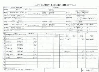
Photograph - The Wilkin Family of Sedgwick - Isaac and Letitia Barcley, 1800s-1900s
The Phil Wilkin Collection contains a series of 11 Items. The related items can be found by clicking on the reference link below. The following history of the Young family and their descendants who lived at the Springs is provided by Phil Wilkin. His Great Grandparents were Frances Young and August Wirth. Phil has also provided notes on the Wilkin Family and some history of the gold mining in Sedgwick. Frances Young's parents Joseph and Margaret Young owned the property called "The Old Place, Preston Vale or Wellington Flat" at Sedgwick near the Springs. Joseph Young owned and Managed the Standard Brewery which was located at Campbells Creek during the late 1800’s early 1900’s. Joseph and Margaret are buried in the Harcourt cemetery. In 1880 August Wirth lived at Mosquito Creek (Lake Eppalock, Victoria) when he married Frances Young. In 1902 they moved to part of Joseph Young's property. They milked cows and sold cattle for a living. One of their children Charles Wirth (Phil Wilkin's Grandfather) bought the land in 1935 after his parents had died. Charles Wirth was a councillor and also was president of the Shire of Strathfieldsaye. The "Old Place" was part of the property owned by members of the family. The old house at the Springs was burnt out by bushfire in January 1944 and much of the stonework was later vandalized by campers. The original Coliban Water Works were designed in 1863 by the Irish engineer Joseph Brady. The system included 70 kilometres of open water channels, aqueducts, syphons and tunnels to carry water (by gravity) from the Coliban River at Malmsbury, north to Castlemaine and Bendigo. Sedgwick is a locality in Central Victoria, Australia. It is located in the City of Greater Bendigo. Facilities include a public hall that opened in 1958 and CFA Rural fire station. It was named Upper Emu Creek until 1901 when it was renamed as Sedgwick after British geologist Adam Sedgwick.Seven historical documents of Isacc and Letitia Barcley who were associated with the Wilkin Family and also with the Springs near Sedgwick. There are 182 photos in this series and can be found at 8683.1 to 8683.11. The series also includes photos of the surrounding farming land and the remains of an old house. There are also some notes on the pioneers of the district.history, bendigo, coliban water, joseph brady, irrigation, the springs, sedgwick, phil wilkin collection, joeseph and margaret young, letitia and isacc barclay -
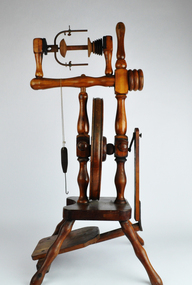 National Wool Museum
Tool - Spinning Wheel, c.1980
This spinning wheel originates from New Zealand; however, it has no distinguishing features relating to its creator such as an inscription, so its exact maker is not known. Gill Stange remembers buying the wheel on Bridge Road in Richmond, approximately 30 years ago. Gill had joined her local Spinners and Weavers Guild after the Ash Wednesday bushfires of 1983. She was a then resident of Mount Macedon and lost everything in the fires. Moving to Melbourne to get away from the scene of much pain, Gill was also in need of a new hobby to help occupy her mind. That is when spinning and weaving entered her life. The local Spinners and Weavers Guild was a great support network for her and with their recommendation, she purchased her own spinning wheel. Her passion was started, and the wheel was to become a treasured item in Gill’s home. She had several spinning wheels within her possession over the years, however, this wheel was her first and always her favourite. When the time came for Gill to downsize, there was simply no longer room for her spinning wheel. This is when she decided to donate the wheel to the National Wool Museum. Gill remembers one highlight was weaving a tablecloth from a traditional German design. It took her two years to complete, with Gill spinning all the wool herself on this wheel. The tablecloth won the first prize in the Melbourne Show in 1987. Gill also used the wheel to teach programs to school children on how to spin and knit wool. She would take the easily transported little wheel, and its accompanying seat, with her to schools. Its small size enabled her to teach children to knit and spin, bringing others the joy that spinning had brought her. Not just limited to schools, Gill also taught programs with the wheel here at the National Wool Museum. It is a fitting home for the wheel, which Gill donated to the National Wool Museum in 2021.Dark varnished wood in a Castle style spinning wheel. The wheel has 8 small spokes which meet a thick outside rim. The outside rim has four golden disc weights on the bottom edge, to aid in the turning of the wheel. The spinning wheel has four legs of turned wood giving a sculptural form, a design pattern which is continued throughout. The wheel has a single medium sized foot pedal. This pedal is well worn with varnish missing from years of use. The wheel is completed with its accompanying chair. Made of the same dark varnished wood, its legs are also of turned wood, continuing the design pattern and uniting the two objects. The chair is very simple outside of the legs, with a medium size base and a thin backrest ending in a rounded head. The chair’s varnish is also starting to fade from years of use. The chair is small, designed to keep the spinning wheel operator at the appropriate height when spinning on the equally small and compact Castle style spinning wheel. Additional parts were donated with the Spinning Wheel. - 3 x Lazy Kates - Spare Maiden. - 450mm Niddy Noddy - Steel teeth brushspinning wool, spinning wheel, ash wednesday, mount macedon, textile production -
 Department of Energy, Environment and Climate Action
Protective Bushfire overalls
At the time of the 1982-83 bushfire season FCV firefighters wore either navy blue issue overalls or their own clothing, generally a checked flannel shirt and jeans. Uncomfortable safety boots and hardhats were issued. The CFA had switched from white overalls to their distinctive yellow kit by 1983. In about 1980, in a far-sighted corporate move for the time, Alan Threader, who was the Chairman of the FCV, established a departmental safety committee, which he personally chaired. The Committee, among other things, wanted to upgrade fire safety clothing. Alan also initiated a radical colour idea after a work trip to the UK in about 1981 and brought home a small sample swatch. Alan believed that the now distinctive bright yellow-green was a good colour contrast to the Victorian bush which is a blue-green hue. Trevor Brown from Stores Branch scored the task to make the change and letters were sent to the UK seeking information about the pigment. The FCV worked with the Commonwealth Dyers Association and Cushen Clothing to replicate the shade on cotton drill, which presented darker when it was treated with the flame-retardant chemical, Proban. The first of the new Kermit Suits were rolled-out in late 1984, and the stylish colour was initially registered and patented to the Department. But it's also fair to say that the new gaudy shade of apparel wasn’t universally popular with staff. The lime green overalls were an Australian first, and forest agencies in other states followed a few years later. In the early 1990s, armed with a pair of dressmaker’s scissors, the baggy one-piece Kermit boilersuits were tailored by Peter Billing from Fire Protection Branch and Trevor Brown in conjunction with the family-owned business, Top Level Workwear, which saw numerous enhancements and prototypes. The two-piece Kermit suits were available in the late 1990s after many years of argy-bargy and complaints from field firefighters. Protective overalls Two types - early FCV (c 1983) and later CNR (1992) forests commission victoria (fcv), protective clothing, safety equipment -
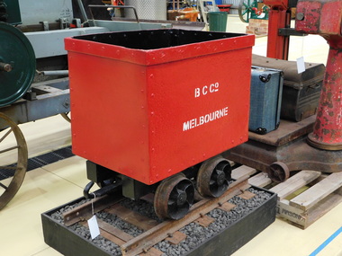 Puffing Billy Railway
Benwerrin Coal Company Coal Skip, circa 1899 - 1904
BENWERRIN COAL COMPANY SKIP This quarter ton coal truck or skip was used at a small mine situated at Benwerrin near Deans Marsh in Victoria’s Otway Ranges. The mine first opened in 1899 and closed in 1904. With the fuel shortages due to World War 2, the Benwerrin Coal Company reopened the mine in 1941. The coal was loaded into skips and winched out of Box’s Creek valley on a narrow gauge incline to a loading point that was close to the Deans Marsh-Lorne Road. It was then taken by road to the Deans Marsh Railway station. The average gradient of the tramway was 1 in 4 over a length of just under 500 metres (1600 feet). The gauge of the tramway has often been referred to as 375mm (or 15 inches) as shown on the map opposite taken from “Sawdust and Steam”. However, actual measurements of the wheels show the gauge to be 400mm (or 16 inches), which is quite unusual as is the small size of the skip itself. The mine produced up to 30 tonnes of brown coal each week until it closed in 1949 and the incline tramway and its skips were abandoned. Preservation of this coal truck came as a result of interest by the Tramway Museum Society of Victoria (TMSV) in the Barlow or Box type rails that it ran on. These rails had originally come from the Beaumaris Horse Tramway and were obtained by the Benwerrin Coal Company from Hayden Bros’ abandoned timber tramway at nearby Barwon Downs. Members of the TMSV visited the mine in the 1960s only to find that most of the tramway had recently been recovered for scrap. There remained a significant number of relics around the mine adits including most of the skips. One of these remained in good condition and it was recovered for preservation in May 1967. It was restored but never displayed and a second restoration took place by the author over 2012/13 so that it could be placed in the Menzies Creek Museum where it was delivered in February 2013. Little remains of the mine today with trestles and sleepers destroyed in the “Ash Wednesday” Bushfires in 1983. References: Houghton, N (1975), Sawdust and Steam, Light Railway Research Society of Australia. Historic - Industrial Narrow Gauge Railway - Benwerrin Coal Company , Benwerrin , Victoria, AustraliaCoal Skip - made of Iron sheet and wrought iron frame & wheelsB,C.Co Melbournepuffing billy, coal skip, benwerrin coal company, narrow gauge -
 Falls Creek Historical Society
Magazine - Brigade Magazine Spring 2016
Brigade Magazine is issued to members of the Victorian CFA. The Spring edition of 2016 includes an article to acknowledge 21 years of service by the Falls Creek CFA. The article was written by Joy Nowakowski on behalf of the Falls Creek CFA with information provided by the Falls Creek Historical Society. Falls Creek Fire Brigade protects Falls Creek Village from fires throughout the year and supports other brigades to fight bushfires nearby and further away. In 2016 the brigade had 23 year-round volunteers. At a celebratory function at Falls Creek in June 2016, alpine pumper and brigade snowmobiles were on display. Falls Creek’s alpine pumper was the first of its kind in Australia. It had a pumping capacity of 4,000 litres a minute and its tracks enabled it to access areas of the village and ski fields. Until 2016 Falls Creek Village has been threatened by two major fires, the worst being in 2003 when CFA crews saved the village and the adjoining ski field infrastructure right at the boundaries. Snow making equipment was used to create a water/fog barrier that helped stop the fires from taking the village. The team that saved the village was considered heroic Support for fighting fires at Falls Creek dates back to 1956 but this support came from Mount Beauty, 30 kilometres down the mountain. Falls Creek locals were concerned by this, so used six available hydrants and a canvas hose to fight any fires on the mountain. In 1964 the SECV gave the village a trailer which could be used with both wheels and skis for summer and winter operations. But this trailer only lasted two years. In the early 1970s, the village was given a 2,000-gallon Ford Blitz 4WD truck, and additional equipment was quickly acquired by the village including a new locally-constructed trailer with a pumper unit. In the 1990s, a change in land status meant the Falls Creek area became the responsibility of CFA. This status was formalised in 1995 by a public meeting that formed Falls Creek Fire Brigade.This magazine is significant because it contains an article celebrating 21 years of Falls Creek CFA.A publication for CFA members which includes stories about recent incidents, brigades, training, events, community safety, health and safety and general CFA news. falls creek cfa, alpine firefighting, falls creek cfa 21 years -
 Federation University Art Collection
Photograph, Clive Hutchison, 'Our Hopes and Future of Morwell' Photographic Collection, 2017
This photographic exhibition was developed by the Federation University-led Community Wellbeing research stream of the Hazelwood Health Study in collaboration with Morwell Neighbourhood House and Gippsland Centre for Art and Design at Federation University Australia. It highlights people's hopes for the future of Morwell has its roots in two unexpected places: the Hazelwood mine fire in 2014 and an academic study into community recovery from that fire. In late summer of 2014 a bushfire spread to the coal mine near the town of Morwell in the LaTrobe Valley, in south-eastern Victoria. The Hazelwood mine fire burned for 45 days, shrouding communities - especially Morwell - in smoke and ash. Strong calls by the community for an investigation into the health impacts of the Hazelwood Mine Fire led to the Department of Health's (Know the Department of Health and Human Services) decision to fund a ten year study of the potential health effects of this smoke event (Known as the Hazelwood Health Study). This exhibition came out of work undertaken by the Community Wellbeing Stream of the Hazelwood Health Study during 2016 and 2017. Based at Federation University Australia's Gippsland Campus, just a few kilometres from where the fire took place, one of our Study's main aims has been to find out from the community how the smoke event impacted on community wellbeing. We also planned to talk to community members about the effectiveness of community rebuilding activities, and find our how these have aided recovery following the smoke event. In 2017 we began working with community organisations on a project to foster community recovery and wellbeing. What emerged from these discussions was the idea for a photographic exhibition, on the theme of 'Our hopes for the future of Morwell'. Invitations to participate were extended to up to 50 members of various community groups. The groups were asked to think of some object that symbolizes their hopes for the future of Morwell. Individuals were then invited to attend a photographic session kindly hosted by the Morwell Neighbourhood House. Each individual was to hold this object while it was photographed, as well as explain what the object represented in terms of Morwell's future. Out of this process twenty nine photographs with their captions were produced, enlarged and framed for exhibiting. The photographs were taken by Clive Hutchison of the Gippsland Centre for Art and Design at Federation University Australia.Twenty nine framed original photographs.morwell, our hopes for the future of morwell, clive hutchison, photography, morwell neighbourhood house, hazelwood health service, gippsland centre for art and design, hazelwood mine fire, haxelwood health study, morwell neighbourhood mine fire, neale stratford, tracie lund, ian brown, susan yell, sue whyte, ainsley ja, ainsley james, michelle duffy, shaun mallia, valerie prokopiv, morwell art and framing -
 Eltham District Historical Society Inc
Photograph - Digital Photograph, Alan King, St Andrews Hotel, 2 February 2008
The c1860 St Andrews Hotel, with the c1930 additions, and the Canary Island Palm, and the surrounding site to the title boundaries are historically, socially and aesthetically significant to the Shire of Nillumbik. The St Andrews Hotel is historically significant because it may have given its name 'St Andrews' to the town (another suggestion is that the name came from St Andrews church) and for its connection to Ewen Hugh Cameron (1831-1915) the prosperous local farmer, member of the Eltham Roads Board/Shire Council and local MP. It is also significant as the oldest hotel building in the former Shire of Eltham, as one of the few surviving buildings connected with the Caledonian goldfields era and as one of a handful of early structures to have survived the 1960s bushfires; the additions and alterations to the hotel reflect its long life. The hotel is socially significant because it has served as an important meeting place for more than 160 years. The Canary Island Palm is historically significant as a rare example of exotic tree planting in this rural area. The tree is aesthetically and historically significant as a local landmark and for its contribution to the streetscape and landscape value. Covered under Heritage Overlay, Nillumbik Planning Scheme. Published: Nillumbik Now and Then / Marguerite Marshall 2008; photographs Alan King with Marguerite Marshall.; p71 Built around 1860, St Andrews Hotel has changed little since it first welcomed thirsty gold diggers from the Caledonia Goldfields. The timber building, with gabled roof, beamed ceilings and a massive fireplace, is Nillumbik Shire’s oldest hotel and has always been an important community centre, particularly in its early days. Fortunately, the hotel and the near-by Canary Island Palm Tree, which is quite rare in this area, survived the 1960s bushfires, along with a few other early buildings. St Andrews (formerly Queenstown) was founded on gold, as were Panton Hill (formerly Kingstown), Research and Diamond Creek, from the mid-1850s to the 1860s. But by the early 20th century common use changed the name Queenstown to St Andrews, possibly after this hotel or after the church or the mining district.1 The Caledonia Diggings were probably named by Scottish settlers after the Roman name for Scotland, despite this land bearing little similarity to their homeland.2 Queenstown, which was proclaimed as a township in 1861, was the gold-mining centre on the Upper Diamond and in the 1850s had up to 600 European inhabitants and a small camp of Chinese on the flats along the creek. Queenstown was the administrative centre of the Upper Diamond with three hotels, a brewery and a slaughterhouse.3 It is unclear which hotel was the district’s first, as distinct from the earliest unlicensed grog shops, some of which operated in tents. John Corke Knell was one of eight unlicensed storekeepers supplying drink to miners at Caledonia in 1857, named by Sgt. McNamara of the Caledonia Police Station.4 In February 1859, Knell apparently bought most of the present hotel’s site at the first township land sales. As he was a local storekeeper, he might have first established a store there.5 Knell and his wife Eliza were early licensees of the St Andrews Hotel. The hotel had eight bedrooms – including three for public use – and the dining-room seated 30 people. It is thought they named the hotel St Andrews after Eliza’s hometown of St Andrews in Scotland. St Andrews Hotel was an important local centre in several ways. In the same building the Knells also operated a post office and general store. In 1867 Mrs Knell was appointed Deputy Registrar of Births and Deaths for Queenstown. The hotel was also used to hold inquests into people’s deaths when the police residence became too small.6 The hotel also became a fashionable destination at Christmas for parties from Melbourne. In 1868, possibly following her husband’s death, Mrs Knell applied for a temporary licence, which was then transferred to Robert Smith after their marriage in 1869. But then, possibly after Robert’s death, Mrs Smith operated the hotel until 1892. This contradicts a report in The Evelyn Observer 1882 that JC Knells of the St Andrews Hotel was granted a publican’s licence in the Queenstown Police Court. At that time he was supposed to have been dead for around 14 years! Although Mrs Smith was a respected citizen, known for her geniality and as an ideal hostess, she had a minor brush with the law when she was fined ten shillings for not lighting a lamp outside her licensed premises.7 From 1892 several publicans owned the hotel including W Atkins, from 1895. In 1909 the licensee was apparently Mrs Smith’s son, Walter Knell, who held the licence until at least the 1920s. Not surprisingly, this old hotel has attracted romantic stories. Mrs Smith is said to be seen roaming the pub in her nightdress – even though she was buried in the Queenstown Cemetery in 1911.8 A musical The Hero of Queenstown, set in the hotel, was written and produced by local actor Reg Evans in the 1970s.This collection of almost 130 photos about places and people within the Shire of Nillumbik, an urban and rural municipality in Melbourne's north, contributes to an understanding of the history of the Shire. Published in 2008 immediately prior to the Black Saturday bushfires of February 7, 2009, it documents sites that were impacted, and in some cases destroyed by the fires. It includes photographs taken especially for the publication, creating a unique time capsule representing the Shire in the early 21st century. It remains the most recent comprehenesive publication devoted to the Shire's history connecting local residents to the past. nillumbik now and then (marshall-king) collection, st andrews hotel