Showing 1537 items matching "aerial photograph"
-
 Stawell Historical Society Inc
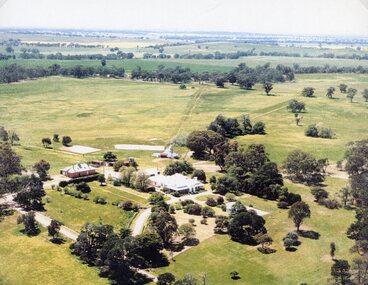
Photograph, "Kirkella" Homestead 2001 -- Aerial Photo
... Aerial photograph of Kirkella homestead taken in 2001... grampians Aerial photograph of Kirkella homestead taken in 2001 ...Aerial photograph of Kirkella homestead taken in 2001. Shows Cricket pitch on Right Hand Side of photo partly surrounded by trees.stawell sport -
 Phillip Island and District Historical Society Inc.
Photograph, 1969
... Black & White Aerial photograph of the two bridges linking... San Remo 1969." Black & White Aerial photograph of the two ...One of 16 photographs and postcards donated by Mary KarneyBlack & White Aerial photograph of the two bridges linking San Remo with Newhaven, Phillip Island. San Remo Jetty and township bottom left foreground. Newhaven on the top.On back: "Two bridges San Remo 1969."the two bridges san remo, san remo to newhaven, phillip island bridges, mary karney -
 Port Melbourne Historical & Preservation Society
Photograph - Aerial view Maribyrnong and Yarra rivers and Coode Island, c. 1976
... Aerial photograph taken from above junction of Yarra... Aerial photograph taken from above junction of Yarra ...Donated to City of Port Melbourne by Councillor Russell GRIFFITHS.Aerial photograph taken from above junction of Yarra and Maribyrnong rivers showing oil and chemical storage farm at Coode Island and four container vessels at Swanson Dock.transport - shipping, piers and wharves - miscellaneous, swanson dock -
 Bendigo Military Museum
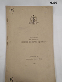
Manual - Australian Survey Corps 1947 - Instructions for the use of Slotted Template Equipment, Australian Survey Corps, 1947
... from aerial photographs, and how the system works.... from aerial photographs, and how the system works. Royal ...This is an instruction manual describing in detail the construction of the templates used for producing map compilation sheets from aerial photographs, and how the system works.Foolscap size, soft carboard covers, 9 x numbered pages, 3 x fold out pages containing two photos on each. Australian Survey Corps Badge on cover. Stapled and re-stapled on Left hand edge.Front Cover, "15" Top Left and Bottom Left corner, "COOPER" and stamped "58" in Top Right, "AHQ/Misc/0015" Bottom Left Corner, Stamped "Eastern Command Survey Service copy 5"royal australian survey corps, rasvy, fortuna, army survey regiment, army svy regt, asr -
Tatura Irrigation & Wartime Camps Museum
Photograph, Aerial of Tatura 1930, 1930
... Early aerial photograph of township of Tatura. Main... Tatura the-murray Early aerial photograph of township of Tatura ...Early aerial photograph of township of Tatura. Main buildings and street can be seen. Copied by W. Purcell. Original held by donor A. Hampton.Black and white photograph taken from a small plane of township of Taturaon back: aerial photo of Tatura 1930. -
 Glenelg Shire Council Cultural Collection
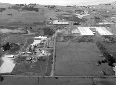
Photograph, CSR Softwoods/Dartmoor Mill, n.d
... Aerial photograph of CSR Softwoods/Dartmoor Mill. Depicts 3... Authority archives. Port of Portland Aerial photograph of CSR ...Port of Portland Authority archives.port of portland -
 Glenelg Shire Council Cultural Collection
Photograph, CSR Softwoods/Dartmoor Mill, n.d
... Aerial photograph of CSR Softwoods/Dartmoor Mill. Depicts 3... Authority archives. Port of Portland Aerial photograph of CSR ...Port of Portland Authority archives.port of portland -
 Glenelg Shire Council Cultural Collection
Photograph, CSR Softwoods/Dartmoor Mill, n.d
... Aerial photograph of CSR Softwoods/Dartmoor Mill. Depicts 3... Authority archives. Port of Portland Aerial photograph of CSR ...Port of Portland Authority archives.port of portland -
Glenelg Shire Council Cultural Collection
Administrative record - Progress Report of Portland Harbour - Royal Commission of Victoria, 1925
... maps of Victoria, Portland and harbour and aerial photographs... and harbour and aerial photographs of Portland and Harbour ...Retrieved from the files of the former Maritime Discovery Centre Manager at the Portland Information Centre (A copy of this report is listed in the manifest from the Port of Portland when collection was offered in 1995)Front: Capt. J W Brown -inkport of portland -
 Ringwood and District Historical Society
Map - State Aerial Survey, Dandenong Ranges Area, Parts of Parishes of Nunawading, Warrandyte and Ringwood - 1956
... , July 1956, from aerial photographs and Cadastral Survey..., July 1956, from aerial photographs and Cadastral Survey ...Map of Ringwood North and parts of Mitcham, Donvale, Park Orchards and Ringwood East compiled by Dept of Lands and Survey, July 1956, from aerial photographs and Cadastral Survey information. Sheet 1, Ringwood A2D or 849 A2D Zone 7. Scale: 4 chains to 1 inch. Contour interval 20 feet. -
 Lakes Entrance Historical Society
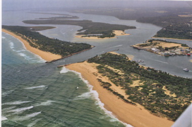
Photograph - Lakes Entrance, Gippsland Ports, 2006 c
... Colour aerial photograph of the Entrance from Bass Strait...Also another copy of same photograph number 03864.1 same ...Also another copy of same photograph number 03864.1 same sizeColour aerial photograph of the Entrance from Bass Strait into the Gippsland Lakes including Bullock Island, Cunninghame Arm and looking NW across Rigby Island Lakes Entrance Victorialand settlement, waterways, lakes entrance -
Glenelg Shire Council Cultural Collection
Photograph - aerial view of train track between Heywood and Rennick, 03/05/1952
... Black and white aerial photographs (aerial survey record... photographs (aerial survey record print) of the railway line between ...Black and white aerial photographs (aerial survey record print) of the railway line between Heywood and Rennick (S.A. border) Taken for Victorian Railways, May 1952. Some photos have annotations later added to the front of the image in penVictorian Railways aerial survey record print of the railway line between Heywood and Rennick (S.A. border) Black and white, white vertical strip on imageFront: Annotations in red ink added at a later date Back: 'Heywood - Rennick 21578 - 19841 279m 49c Rennick ' - all black ink. Purple VR aerial survey stamp. '3 May 1952' - black stampvictorian railways, train track, travel, transport -
Glenelg Shire Council Cultural Collection
Photograph - Photograph - Portland Harbour, n.d
... Aerial sepia photograph of Portland Harbour, taken from... Back: harb026- pencil Aerial sepia photograph of Portland ...Port of Portland AuthorityBack: harb026- pencilport of portland archives, portland harbour, aerial sepia -
 City of Kingston
Photograph - Black and white, c. 1944
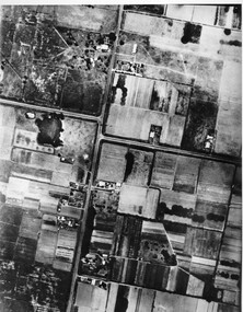
... Aerial photograph of Moorabbin, including Chesterville Road... Parkdale Aerial photograph of Moorabbin, including Chesterville ...Aerial photograph of Moorabbin, including Chesterville Road, Keys Road and Wickham Road, Moorabbin, Briggs cottage, Neill's waterhole, McKittrick property, site of FRUMELBlack and white aerial view of Moorabbin. Houses, market garens, roads, and water features are all clearly visible.Handwritten in red ink on reverseL A 603 / 97% [in red circle] Handwritten in blue ink on reverse: 9502 06111 / M'bbinmoorabbin, city of moorabbin, chesterville, keys, wickham -
Glenelg Shire Council Cultural Collection
Photograph - Photograph - N.W., of T.B.& S. abattoir; red brick wool store; petroleum installations; north/central Portland residential areas and Portland Harbour, 1955
... A black and white aerial photograph taken from the N.W... and white aerial photograph taken from the N.W., of T.B.& S ...Port of Portland CollectionFront: NOV 1955 'AIRSPY PHOTO' ref NO 2/b/74port of portland archives, portland harbour, portland residential areas, tb and s abattoir, red brick wool store, petroleum installations -
Port Melbourne Historical & Preservation Society
Photograph - Aerial view of four US ships at princes Pier, Port Melbourne, Airsky, Aug 1925
... 'sepia' lasercopy from 1925 aerial photograph of four US.... 'sepia' lasercopy from 1925 aerial photograph of four US ships ...After death of Euralee, the original was found among her papers, mounted on brown cardboard'sepia' lasercopy from 1925 aerial photograph of four US ships at Princes Pier in August 1925, found by Clark Towson after his grandmother Euralee's death in December 2001original had the four ships names at Princes Pier, Port Melbourne, August 1925.piers and wharves - princes pier, uss oklahoma, uss seattle, uss nevada, uss pennsylvania -
 Ringwood and District Historical Society
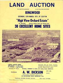
Flyer, Land Auction Sale Brochure, High View Orchard Estate, Ringwood, Vic. - 1971
... aerial photograph, map, and summary of local facilities... aerial photograph, map, and summary of local facilities ...Double-sided advertisement for Ringwood High View Orchard Estate land auction sale on Saturday, 13th March, 1971, including aerial photograph, map, and summary of local facilities and services.Subdivision includes Wonga Road, Oban Road, Sang Court, Ambrie Avenue, Hendra Grove, and Mullum Mullum Road. Agent - A.W. Dickson Pty. Ltd., 136 Whitehorse Road, Ringwood, 3134. Telephones: 870 6000, 870 6007, 870 7016, after hours 870 6868. A separate copy of the advertisement includes a local newspaper follow-up clipping reports thirty home sites grossing $102,350 at the auction. -
Phillip Island and District Historical Society Inc.
Photograph, circa 1940
... . local history photography photographs slides film aerial views ...Commercially printed approx 1940s. Bayview Guesthouse (lower right foreshore) was burnt down in 1950s.Jetty diagonally lower left - township in foreground - open paddocks in background. Thompson Avenue & Cypress trees lower middle to upper right. Taken approx 1940sAerial view of Cowes Phillip Island No. 147local history, photography, photographs, slides, film, aerial views of cowes, phillip island, black & white photograph, aerial views cowes -
 Bendigo Historical Society Inc.
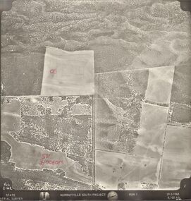
Photograph - MURRAYVILLE SOUTH PROJECT
... PHOTOGRAPH Aerial murrayville south project photos Murrayville South ...State Aerial Survey. A set of aerial surveys related to the Murrayville South Project. Run 1. Vic. 2162. 29-2-1968. 53 photos.photograph, aerial, murrayville south project, photos, murrayville south project, state aerial survey, surveys, murrayville, photographs, photography, aerial photography -
 Tatura Irrigation & Wartime Camps Museum
Photograph, camp 1 aerial photo 1946
... Tatura the-murray camp 1 aerial photo 1946 photograph camp 1 ...camp 1 aerial photo 1946, photograph -
 Bendigo Historical Society Inc.
Map - BENDIGO MAP AERIAL VIEW, 1934
... PHOTOGRAPH Aerial bendigo 1934 Map of Bendigo. Aerial View of Bendigo ...Map of Bendigo. Aerial View of Bendigo taken in 1934. Published by City of Great Bendigo.photograph, aerial, bendigo 1934 -
 Bendigo Historical Society Inc.
Map - BENDIGO MAP AERIAL VIEW
... PHOTOGRAPH Aerial bendigo Map of Bendigo. Aerial View of Bendigo ...Map of Bendigo. Aerial View of Bendigo. Published by City of Bendigo. Undated.photograph, aerial, bendigo -
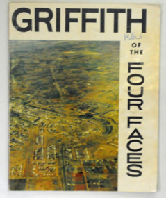 Orbost & District Historical Society
book, Riverina Commercial Press, Griffith, 1963
... Faces". on the front cover is a coloured aerial photograph... is a coloured aerial photograph of Griffith, New South Wales. The book ...Albert Jaime Grassby, AM was an Australian politician who served as Minister for Immigration in the Labor Whitlam Government. He completed reforms in immigration and human rights, and is often known as the father of Australian "multiculturalism". Prior to this Grassby worked as a journalist and information officer for the CSIRO in Griffith, New South Wales.This item is a useful reference tool on the history of Griffith in New South Wales.A 46 pp paper back book titled, " Griffith of the Four Faces". on the front cover is a coloured aerial photograph of Griffith, New South Wales. The book contains coloured photographs and a history of the area.on front cover hand-written in blue pen - "M. Gilbert"griffith-new-south-wales griffith-history -
 Wangaratta High School
WHS Yearbook -Korrumbeia, 1984
... featuring a full page aerial photograph of WHS students standing... featuring a full page aerial photograph of WHS students standing ...Black and white bound photocopy of the 1984 yearbook featuring a full page aerial photograph of WHS students standing in a crowd in the shape of text reading WANG HIGH 84 in front of the school buildings -
Tatura Irrigation & Wartime Camps Museum
Photograph, Eildon Township, 1957
... Medium sized black and white photo. Aerial photograph... sized black and white photo. Aerial photograph - looking down ...Taken by photographer for State Rivers and Water Supply Commission.Medium sized black and white photo. Aerial photograph - looking down on township in middle foreground - overflow dam to the right, middle distance - dam wall with reservoir beyond - mountain tops forming horizonOn frame below photo: "Eildon Township."victoria state rivers and water supply commission, eildon -
 Hume City Civic Collection
Photograph, 1972
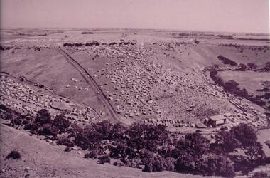
... An aerial photograph of a crowd of people on a hillside... george evans collection An aerial photograph of a crowd of people ...The photograph was taken during the 1972 Sunbury Pop Festival which was staged on a property owned by George Duncan. The site is on the banks of the Jacksons Creek between Sunbury and Diggers Rest.An aerial photograph of a crowd of people on a hillside and along a creek valley with a stage set up. On the LHS there is a large marquee surrounded by cars and pitched tents. There are trees around the creek and vast open paddocks in the distance.sunbury pop festival, jacksons creek, duncan, george, george evans collection -
 Bendigo Military Museum
Photograph - Aerial Photography - Mohogany Ship Search Warrnambool Victoria, Victorian Lands Department, 3.1.1981
... These Victorian Lands Dept Aerial Photographs were acquired... goldfields These Victorian Lands Dept Aerial Photographs were ...These Victorian Lands Dept Aerial Photographs were acquired by the Army Survey Regiment to help locate a Mohogany Ship wreck near Warrnambool Victoria as part of a unit Regimental Training ExerciseSeven Aerial photographic Prints and Film Negatives and positives of the same images. Images are Numbered 3562- 15,16,17,18,19, 29 and 30.royal australian survey corps, rasvy, fortuna, army survey regiment, army svy regt, asr -
 Heidelberg Golf Club
Album - Photograph Album, Heidelberg Golf Club, Clubhouse redevelopment, 1998; Course development,2000-2001; Course redesign, 1967, 1967-2001
... . Includes aerial photographs of golf club, some stamped "proof".... Includes aerial photographs of golf club, some stamped "proof ...Album containing about 70 color photographs of Clubhouse redevelopment, 1998; Course development,2000-2001; Course redesign, 1967. Includes aerial photographs of golf club, some stamped "proof"Album #2 in the photograph collection at HGCBlack spiral bound album. Contains approx. 70 colour photographs of various sizes.heidelberg golf club, clubhouse redevelopment 1998, course design 1967, heidelberg golf course -
Glenelg Shire Council Cultural Collection
Photograph - Photograph - Portland Smelter, c. 1980
... Framed aerial photograph of Portland smelter taken in 1908... framer Framed aerial photograph of Portland smelter taken in 1908 ...Previously displayed in offices at the smelterFramed aerial photograph of Portland smelter taken in 1908's. Image shows Dutton way and Narrawong in the background. Gilt wooden frame. Glass covers photo. Brown paper on back of photo, hanging cord.Front: Back- Label for Gary Hayman, picture framer -
4th/19th Prince of Wales's Light Horse Regiment Unit History Room
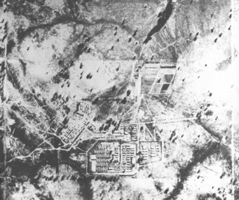
Aerial Photographs, Broadmeadows Victoria camp?, late 1940's
... A set of 30 aerial photographs of what could... aerial photographs of what could be Broadmeadows Victoria camp ...A set of 30 aerial photographs of what could be Broadmeadows Victoria camp. Some show the terrain, others the camp layout and others of a tank regiment formed up in Squadrons. The majority of the tanks appear to be General Grantsairial photos, tank camp, broadmeadows