Showing 1464 items
matching between wars
-
 Halls Gap & Grampians Historical Society
Book - B/W
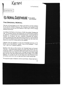
Norval Guest-House Aginda and Wettenhall The original Norval The story of Norval begins in 1917 when it was built as a private residence for Mr and Mrs William Thompson. Mrs Thompson was a pioneer of the tourist business, having come from Ballarat to Hall's Gap in 1909 to manage Bellfield Guest-house According to Ida Stanton, in her history of Hall's Gap entitled "Bridging the Gap", Mr Thompson and his wife acquired the six roomed shearers quarters at "Hankelow", on land leased by the Wettenhall family, on the south side of Bellfield. Mr Thompson, she says, completely dismantled the quarters, carefully marking each board, then hired George McKeon to cart the material up to where the original Norval house stood. With great care, the rooms were rebuilt into a home for William and his wife Mathilda. Catherine Good, the daughter of Viola (nee Wettenhall) and niece of Dr Roland, in here "Recollections" entitled "Look to the Mountains - Viola's View 1887-1979", mentions Hankelow. Speaking of her days at Glen Holford, the Wettenhall home at Pomonal, Viola says "Verona and Francie Dennis, my cousins, and I went for one very exciting trip. Father (i.e Dr Roland's father) had bought 300 acres in the Gap to take sheep from Carr's Plains in time of drought, and had a little cottage there with one of the Glen Holford men and his wife in charge. It was called Hankelow. So we three set off over the Range from Glen Holford on foot and leading a pack horse with our night attire and no doubt sponge bags. "We stayed the night at Hankelow with Jim and Minnie. Minnie had been a housemaid at Glen Holford. I was very fond of her. It makes one laugh to think of the excitement of "roughing it"! Minnie gave us a lovely dinner with meringues, and cream, I remember, then early morning tea. After breakfast we were driven in the buggy to the foot of the Goat Rock (since renamed Mt Rosea) and off we went - walking in our long skirts and ankle boots. There was no track of any kind, nor blazed trail - we just made for the top. It was rather frightening at times because we couldn't see where the top was an it always seemed to get further and further away. The last mile was so terribly steep, with a lot of lose shale where you went up twelve inches and slipped back six. Now you motor to about a couple of miles from the top and then have a graded path. Anyway, we got there and back safely and were rewarded with a magnificent view" By a strange coincidence, Hankelow, the source of Norval Guest-house in times past (if the name can be applied to the property as a whole, which seems likely) is in fact also the source of our Wettenhall Campsite! Hankelow was named after a property owned by the Wettenhall family in England. In 1917 William and Mathilda retired to their newly built home (Norval) "to escape from the tourist business" However, so many people made requests to stay with them that they found it necessary to add several more rooms and sleepouts to their home. In this way, early in 1921, the guest-house began to take shape. Mr Thompson, a former librarian of the Mechanics Institute in Ballarat, named the house "Norval". The name "Norval" comes from a quotation from the play 'Douglas" by John Home. Written in the mid-16th century the play is set in the Grampian Mountains of Scotland. The story is of a boy who was parted from this mother during his early childhood, and was given to a shepherd who raised him. Some eighteen years later the mother by chance happens to meet here son, and not knowing his true identity, asks his name. He answers, "My name is Norval; and in the Grampian hills my father feeds his flocks." Perhaps it was simply because "Norval" was associated with the "Grampians" that it was chosen by Mr Thompson. He may also have been conscious of feeding "flocks" of tourists in his expanding, guest-house. Norval Guest-house prospered. It was known for its fine cooking and friendly atmosphere - a tradition which has carried through to the modern Norval! It closed between 1940 and 1949 because of the second world war. In 1949 it was decided to almost completely rebuild the house. Most of the old building (Hankelow plus) was demolished and rebuilt to a much larger and more modern plan. And then, on May 1, 1965, it was purchased by the Committee of Management of the Methodist and Presbyterian Conference Centres. At this time the guest-house was owned and operated by Marjorie and Lachland McLennan, Mrs McLennan being the daughter of William and Mathilda Thompson, the pioneers of the establishment. The McLennans had operated the Guest-house since about 1930.Photocopy 2 pages of article from book titled 'In the Making' title of article Norval guest House the original Norvalaccommodation, guesthouses, norval -
 Halls Gap & Grampians Historical Society
Map - Coloured
Background on Bridle Path up Stony Creek Gorge Pre 1840 C. B. Hall, squatter on Mokepilly Run 1841-1842, first European to discover the Fyans Creek valley, the entrance of which became known as Hall's Gap. He later recorded that he followed a number of tracks which he assumed had been made by the Aboriginies and described one as "leading up a wild romantic glen and over on to the source of the Glenelg River". This could well have been the route taken up Stony Creek gorge by the first timber-cutters in this part of the Grampians to the saddle between the Wonderland and Mt. Difficult ranges known as Valley Gap 1850s/60s Timber cutters and shingle splitters were reported to be moving into the eastern side of the Grampians and by the mid 1860s there were a number of families connected to the supplying of timber to Pleasant Creek living in the "Hall's Gap ranges". John Wakeham, the first store owner in Pleasant Creek in 1854, established a timer-mill in upper Stony Creek Gorge in the late 1850s. Wakeham is credited for the clearing and levelling of the first bridle-path up the gorge. 1870s By the mid 1870s the track had been extended over Valley Gap to the Victoria Forest (the upper region of the Victoria Valley). McKeon's bullock team was known to have hauled red gum from the Valley to Stawell in the late 1870s and the 1880s. 1880s In 1887 an article in the Pleasant Creek news describes the Stony Creek Gorge track as "being a ledge alongside the mountain range, formed in the early days with the aid of earth and timber, along which the bullock teams used to travel to Horsham and plains of the Wimmera beyond." 1890s Gold was discovered in the catchment area of Stony Creek and by the end of the 1890s a new track was built from "near the junction of Fyan's and Stony Creeks, up the gorge to the diggings settlement. The mining Department had paid L300 for its construction and, when completed, the track was "three miles and 30 chains in length, the side cuttings at the narrowest part being 10 feet between" and "the watercourses which cross the track at various points" having been "filled up with rocks rolled down the sides of the hills, and consequently there can be no damage caused by bushfires which destroyed the former wooden bridges erected on the old track to Wakeham's saw-mill, the remains of which are still to be seen at the side of the diggings" The article goes on to further describe the track as one which "can with ease travel with a two horse conveyance either up or down" and that the workmen engaged in the construction of the track would be attending "a ball that night at McKeon's farm near the mouth of the gap to celebrate the successful completion of the undertaking". 1900s At what time the bridle path was extended beyond Valley Gap to the Wartook basin on the Mt. Difficult Range has not yet been determined. However, it is known that, by the turn of the century, people were travelling between Halls Gap and the caretakers' residence at Wartook Reservoir along what was now known as the "Bluff Road. Wartook's embankment had been constructed in 1887 and at that time there was already a track from Rosebrook Station homestead (near the present day Wartook Pottery) to the reservoir. Philip Rose owned both Rosebrook and Wartook Stations from the mid 1840s to the late 1850s and had regularly leased the Wartook basin to Cobb & Co. to rest horses there. 1920s Following the war of 1914-1918, tourism really took off in the Grampians, and Halls Gap rapidly grew. People would travel as far as they could on the many tracks then hike to the many lookouts being discovered by local tour guides. This led to the need for access across the range so that horse riders and the increasing number of vehicles could travel between Horsham and Halls Gap. To this end, the Bluff Road was improved and extended on 1929 and at its opening in March, 1930, by Lady Somers it was renamed the Mt. Victory Road.Map of Mt Victory Road and othersaccess routes, mt victory rd, bridle path, roads -
 4th/19th Prince of Wales's Light Horse Regiment Unit History Room
Hat Khaki Fur Felt, est 1940's
The Volunteer Defence Corps (VDC) was an Australian part-time volunteer military force of World War II modelled on the British Home Guard. The VDC was established in July 1940 by the Returned and Services League of Australia (RSL) and was initially composed of ex-servicemen who had served in World War 1. The government took over control of the VDC in May 1941 and gave the organisation the role of training for guerrilla warfare, collecting local intelligence and providing static defence of each unit's home area. General Harry Chauvel, who had retired in 1930, was recalled to duty in 1940 and appointed Inspector-General of the VDC. Chauvel held this position until his death in March 1945. Following the outbreak of the Pacific War, the Government expanded the VDC in February 1942. Membership was open to men aged between 18 and 60, including those working in reserved occupations. As a result, the VDC reached a peak strength of almost 100,000 in units across Australia. As the perceived threat to Australia declined, the VDC's role changed from static defence to operating anti-aircraft artillery, coastal artillery and searchlights. Members of inland VDC units were freed from having to attend regular training in May 1944 and the VDC was officially disbanded on 24 August 1945Hat Khaki Fur Felt with green cloth single band puggaree which has cotton Volunteer Defence Corps badge sewn on, brass rising sun badge on brimMaker's label on head band -RG & RI Stebbins, 14 Willow Court, Donald , Vic 3480 -
 Eltham District Historical Society Inc
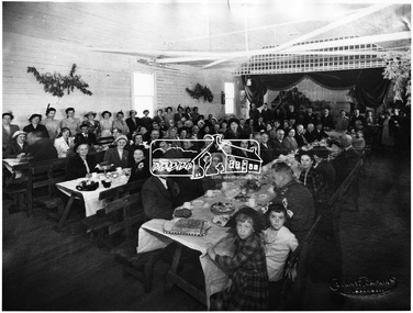
Photograph, Queenstown (St. Andrews); sports meeting Easter Monday, c.1918
Towards end of 1914-1918 war. Photo was taken where the hall was located at the time of collection (1970).This photo forms part of a collection of photographs gathered by the Shire of Eltham for their centenary project book,"Pioneers and Painters: 100 years of the Shire of Eltham" by Alan Marshall (1971). The collection of over 500 images is held in partnership between Eltham District Historical Society and Yarra Plenty Regional Library (Eltham Library) and is now formally known as the 'The Shire of Eltham Pioneers Photograph Collection.' It is significant in being the first community sourced collection representing the places and people of the Shire's first one hundred years.Digital image, 9 x 12.5 cm print and 4 x 5 inch B&W Negsepp, shire of eltham pioneers photograph collection, queenstown -
 Eltham District Historical Society Inc
Photograph, Council Office. Kangaroo Ground, formerly printing office of the "Evelyn Observer"
Council Office. Kangaroo Ground, formerly printing office of the "Evelyn Observer" until the name was changed to the "Advertiser" and the company moved to Hurstbridge during the 1914-1918 war. Shire Office until destroyed by fire 8th Feb., 1934. Source: Mrs. McMinn, KinglakeThis photo forms part of a collection of photographs gathered by the Shire of Eltham for their centenary project book,"Pioneers and Painters: 100 years of the Shire of Eltham" by Alan Marshall (1971). The collection of over 500 images is held in partnership between Eltham District Historical Society and Yarra Plenty Regional Library (Eltham Library) and is now formally known as the 'The Shire of Eltham Pioneers Photograph Collection.' It is significant in being the first community sourced collection representing the places and people of the Shire's first one hundred years.Digital imagesepp, shire of eltham pioneers photograph collection, kangaroo ground, council office, evelyn observer -
 Eltham District Historical Society Inc
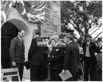
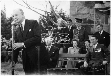
Photograph, Kangaroo Ground. Dedication of Tower and Cottage by His Excellency the Governor of Victoria, Gen. Sir Dallas Brooks, K.C.B., C.M.G., D.S.O., K.St.J., 16 November 1951
Source: Shire of ElthamThis photo forms part of a collection of photographs gathered by the Shire of Eltham for their centenary project book,"Pioneers and Painters: 100 years of the Shire of Eltham" by Alan Marshall (1971). The collection of over 500 images is held in partnership between Eltham District Historical Society and Yarra Plenty Regional Library (Eltham Library) and is now formally known as the 'The Shire of Eltham Pioneers Photograph Collection.' It is significant in being the first community sourced collection representing the places and people of the Shire's first one hundred years.Digital imagesepp, shire of eltham pioneers photograph collection, kangaroo ground, sir dallas brooks, governor of victoria, war memorial tower -
 Eltham District Historical Society Inc
Photograph, Shire of Eltham War Memorial. Dedication of Tower and Cottage, 16 November 1951
Source: Shire of ElthamThis photo forms part of a collection of photographs gathered by the Shire of Eltham for their centenary project book,"Pioneers and Painters: 100 years of the Shire of Eltham" by Alan Marshall (1971). The collection of over 500 images is held in partnership between Eltham District Historical Society and Yarra Plenty Regional Library (Eltham Library) and is now formally known as the 'The Shire of Eltham Pioneers Photograph Collection.' It is significant in being the first community sourced collection representing the places and people of the Shire's first one hundred years.Digital imagesepp, shire of eltham pioneers photograph collection, kangaroo ground, war memorial tower, dedication -
 Eltham District Historical Society Inc
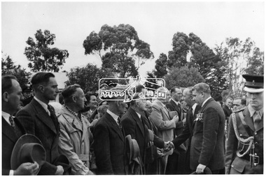
Photograph, Shire of Eltham War Memorial. Dedication of Tower and Cottage. Gen. Sir Dallas Brooks meeting ex-servicemen of the district, 16 November 1951
Source: Shire of ElthamThis photo forms part of a collection of photographs gathered by the Shire of Eltham for their centenary project book,"Pioneers and Painters: 100 years of the Shire of Eltham" by Alan Marshall (1971). The collection of over 500 images is held in partnership between Eltham District Historical Society and Yarra Plenty Regional Library (Eltham Library) and is now formally known as the 'The Shire of Eltham Pioneers Photograph Collection.' It is significant in being the first community sourced collection representing the places and people of the Shire's first one hundred years.Digital imagesepp, shire of eltham pioneers photograph collection, kangaroo ground, war memorial tower, dedication, sir dallas brooks -
 Eltham District Historical Society Inc
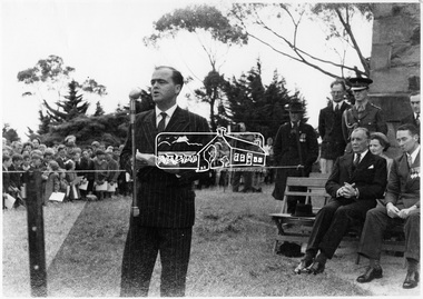
Photograph, Dedication of Tower and Cottage at Kangaroo Ground, 16 November 1951
Source: Shire of ElthamThis photo forms part of a collection of photographs gathered by the Shire of Eltham for their centenary project book,"Pioneers and Painters: 100 years of the Shire of Eltham" by Alan Marshall (1971). The collection of over 500 images is held in partnership between Eltham District Historical Society and Yarra Plenty Regional Library (Eltham Library) and is now formally known as the 'The Shire of Eltham Pioneers Photograph Collection.' It is significant in being the first community sourced collection representing the places and people of the Shire's first one hundred years.Digital imagesepp, shire of eltham pioneers photograph collection, kangaroo ground, war memorial tower, dedication -
 Eltham District Historical Society Inc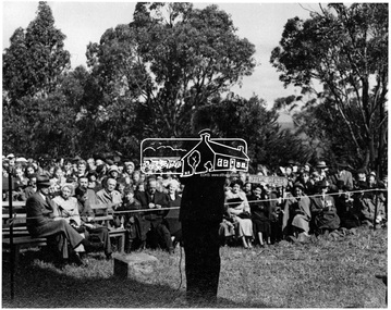
Photograph, War Memorial at Kangaroo Ground. Dedication of Tower and Cottage by Gen. Sir Dallas Brooks, K.C.B., C.M.G., D.S.O., K.St.J., 16 November 1951
Source: Shire of ElthamThis photo forms part of a collection of photographs gathered by the Shire of Eltham for their centenary project book,"Pioneers and Painters: 100 years of the Shire of Eltham" by Alan Marshall (1971). The collection of over 500 images is held in partnership between Eltham District Historical Society and Yarra Plenty Regional Library (Eltham Library) and is now formally known as the 'The Shire of Eltham Pioneers Photograph Collection.' It is significant in being the first community sourced collection representing the places and people of the Shire's first one hundred years.Digital imagesepp, shire of eltham pioneers photograph collection, kangaroo ground, war memorial tower, dedication, sir dallas brooks, governor of victoria -
 Eltham District Historical Society Inc
Photograph, Official guests being entertained after Dedication of Tower and Cottage by Gen. Sir Dallas Brooks, K.C.B., C.M.G., D.S.O., K.St.J., 16 November 1951
Source: Shire of ElthamThis photo forms part of a collection of photographs gathered by the Shire of Eltham for their centenary project book,"Pioneers and Painters: 100 years of the Shire of Eltham" by Alan Marshall (1971). The collection of over 500 images is held in partnership between Eltham District Historical Society and Yarra Plenty Regional Library (Eltham Library) and is now formally known as the 'The Shire of Eltham Pioneers Photograph Collection.' It is significant in being the first community sourced collection representing the places and people of the Shire's first one hundred years.Digital imagesepp, shire of eltham pioneers photograph collection, kangaroo ground, war memorial tower, dedication, sir dallas brooks, governor of victoria -
 Eltham District Historical Society Inc
Photograph, View of Kangaroo Ground District from War Memorial Tower, 16 November 1951, 16 Nov. 1951
View from Shire of Eltham War Memorial tower at Garden Hill, Kangaroo Ground, probably taken shortly after the memorial's re-dedication held 8 Nov. 1951. On November 11th 1926 the Shire of Eltham War Memorial Tower at Kangaroo Ground was opened. It is regarded as one of Melbourne’s most outstanding lookout towers. It commands a magnificent 360 degree panorama from Kinglake across the Diamond Valley to Macedon and the You Yangs. It is built on a peak which was once a volcano, 237 metres above sea level. After World War one a memorial cairn was erected on the site, and in 1925 a committee of public-minded citizens began to plan for a tower. Many generous donations of material and money were forthcoming so that in 1926 the Governor General Lord Stonehaven was able to unveil the plaque before a crowd of 500 people There was some concern in the 1960s when the Forests Commission wanted to build a firespotters cabin on the top. At first R.S.L. branches opposed the idea, but it was realised that this use could combine with its use as a tourist attraction, and would ensure its maintenance for the future. Today the Kangaroo Ground tower provides one of the best views around Melbourne and is a fitting memorial to those who died in two world wars. From: Historic items for Diamond Valley Community Radio September 1990 (EDHS collection) On November 8th, 1951, the memorial was re-dedicated by the Governor of Victoria, Sir Dallas Brookes with the addition of the names of men from the Shire of Eltham who fell in the Second World War. Further wreaths were added in time for the 2001 Reembrance Day service to commemorate the men from th shire who had fallen in the Malayan, Korean, Borneo and Vietnam campaigns.This photo forms part of a collection of photographs gathered by the Shire of Eltham for their centenary project book,"Pioneers and Painters: 100 years of the Shire of Eltham" by Alan Marshall (1971). The collection of over 500 images is held in partnership between Eltham District Historical Society and Yarra Plenty Regional Library (Eltham Library) and is now formally known as the 'The Shire of Eltham Pioneers Photograph Collection.' It is significant in being the first community sourced collection representing the places and people of the Shire's first one hundred years.Digital image 120 format B&W negative B&W Print 12.5 x 17.5 cmsepp, shire of eltham pioneers photograph collection, kangaroo ground, garden hill, kangaroo ground tower, lookout, memorial park, panorama, shire of eltham war memorial, view, vista -
 Eltham District Historical Society Inc
Negative - Photograph, Unveiling of War Memorial Obelisk, corner of Main Road and Bridge Street, Eltham
The unveiling of the Eltham Obelisk War Memorial was performed by the Rev. Padre Charles Tregear, assisted by Church of England vicar, Mr Safsford on August 3, 1919. Reproduced page 99 of "Pioneers & Painters." "Beneath a lonely pine tree on the hill crest out from Eltham, where the Greensborough Road junctions with the main Melbourne Road, Eltham has erected an everlasting tribute to the memory of the fallen heroes of the district. It is an obelisk of Harcourt granite in the rough, bearing an appropriate inscription and 27 names—an unpretentious monument by the wayside, which will stand for all time silently expressing the appreciation of the living for the sacrifice of the dead. The obelisk stands 14 feet high. ... Representatives of every house in the town, and many people from the surrounding district, gathered around the obelisk for the opening ceremony. The spring-like sunshine of the afternoon attracted everybody out of doors. There must have been 700 people present when the Lieutenant-Governor, Sir William Irvine, removed the draping of flags and revealed the names on the obelisk, the base of which was surrounded by wreaths and branches of wattle bloom, placed there by parents whose sorrow at the loss of sons was blunted, for the day at least, by feelings of pride. .." Age, Monday 4 August 1919, page 8 This was the memorial's orginal location. It has been relocated numerous times.This photo forms part of a collection of photographs gathered by the Shire of Eltham for their centenary project book,"Pioneers and Painters: 100 years of the Shire of Eltham" by Alan Marshall (1971). The collection of over 500 images is held in partnership between Eltham District Historical Society and Yarra Plenty Regional Library (Eltham Library) and is now formally known as the 'The Shire of Eltham Pioneers Photograph Collection.' It is significant in being the first community sourced collection representing the places and people of the Shire's first one hundred years.Digital image 4 x 5 inch B&W Negsepp, shire of eltham pioneers photograph collection, eltham, main road, bridge street, eltham war memorial, obelisk, obelisk corner -
 Kiewa Valley Historical Society
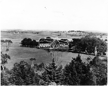
Photograph of Kiewa Valley Panorama, Farming lands within the Kiewa Valley in1950s, Circa 1950
This photograph shows how (early to mid1900s), before the establishment of the Mount Beauty "gated" village, the Kiewa Valley was farmed and the scarce population was spread out over acres of productive land. This photograph catches a time before (what appeared to the local farmers as the invasion by a mass of construction workers) when this remote valley was part of a "lay back" rural landscape,occasionally visited by friends and some wayward tourists. The mountain ranges provided an adequate barrier against the way-would traveller. The immigration numbers coming into Australia was still quite small ( due to the "white" Australia policy) which was in force before World War II. After World War II a mass of displaced European refugees and migrants boosted the Australian population and provided for a greater degree of diverse professions and rural related work force.This photograph depicts the borderline in time between an exclusively rural based population and respective activities(early 1900s)to the present (2000 on wards) integrated village, tourist and retiree/holiday area. The time when land was exclusively used in agriculture is over and the impact of cheaper rural produce from Asian markets will see a shift of land useage and population activities. The Kiewa Valley is loosing its hiding place and is becoming more and more a source of untapped residential land. Black and white photograph of farming/grazing land useage, before the establishment of the Mount Beauty Village. Small pockets of residentual houses can be viewed. Road access (unsealed dirt) was typical of that provided in rural regions in the 1950s. The photo is on 200gms paper and not on photographic paper.kiewa valley in the early1900s, grazing in the kiewa valley, sec victoria -
 Kiewa Valley Historical Society
Photograph of Snow Covered Catchment Area Vic, Snow Covered Catchment Area Victorian Alps - 1950s, Circa 1950
This photograph details (early to mid1950s), the Victorian Alpine region when this remote area was part of a "lay back" rural landscape,occasionally visited by recreational adventurers and some wayward tourists. The mountain ranges had provided an adequate barrier against the way-would traveller, but with the opening up of this region by the provision of improved roadways and accommodation facilities, courtesy of the Kiewa Valley Hydro Electricity Scheme, changes such as tourism and its impact upon the "natural" state started to show its side effects (clearing of the land). The expansion of the European immigration numbers (1950s) coming into Australia was increasing after World War II which not only provided increased construction workers to the region but also immigrants who appreciated alpine regions. Some of these immigrants contributed to the expansion of the region and provided for a greater degree of diverse professions and rural related work force.This photograph depicts the borderline in time between an exclusively rural based population and respective activities(early 1900s)to the present (2000 on wards) integrated village, tourist and retiree/holiday area. The time when land was exclusively used in agriculture and Alpine grazing lands is over. The Kiewa Valley is loosing its hiding place and is becoming more and more a source of untapped residential land and winter time recreational adventure lands. The changes brought about by modern technologies involving recreational activities such as hang gliding, gliding (local airstrip), mountain bikes, car rallies and their associated clubs is providing for an increased short term population boost. These together with the attractions for retirees is changing not only the physical nature of the Kiewa valley but also its "soul".This item is a black and white photograph of a section of snow covered catchment area in the Victorian Alps in the mid 1900. It is on 200 gms paper but not on photographic paper and has a white boarder (3 mm).kiewa valley tourism, victorian alps, alternate energy supplies, alpine population growth -
 Kiewa Valley Historical Society
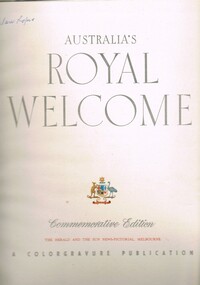
Book - Non Fiction History, Australia's Royal Welcome 1954, circa 1954
This publication covers the mid 1900s and relates to a period where the majority of the Australian population was engrossed with the Queen of Australia, even though her Highness did not reside on this continent. The period covered was before the great immigration insurgence from Europe.The Labour Party's "White Australian" policy was a hinderance and a barrier towards the Asian and African prospective immigrants. The motto Queen and Country was still very ingrained in the rural population. This period in Australian domestic self reliance, brought about the growing strength and very active trade union movement and their staunch support for the Tariff protection against a growing swell of imported goods. This self reliance psyche was essentially a by product of World War II, and the isolation felt by the Australian People. The Queen (royalty) was the binding force holding the British Empire together which was emphasised with her popularity when touring Australia Queen Elizabeth's visited the MCG twice in 1954 1. to attend an assembly of ex-servicemen and women's organisations 2. to attend a Children's Display. She also visited Government House and visited Country Victoria on the Royal train from 24th Feb - 9th March.The Kiewa Valley and all the rural areas in the region were still very much tied to the "mother land" and trade between Britain and Australia was very strong. Trade with Asian manufacturers was minimal and needed the late 1900s to see both the trade and immigration barriers fall. This book was produced during a time when the majority of Australians looked more to England for trade and companionship. The agricultural trade with England and Europe was very high and the motto of the time was "Australia grows on the sheep's back". Late 1900's saw the motto "Australia grows on the miner's back" The Queen was still very popular then which was emphasised by the large crowds which greeted her on tour. Residents of Mt Beauty including Cubs, Brownies, Scouts and Guides travelled to Benalla to see the Queen. Clare Roper was a founding member of the KVHS and attended a garden party at Buckingham Palace representing the local CWA. She has purchased this book and therefore giving this a close historical significance connection, it has good provenance and interpretive capacity. This hard(blue coloured) covered book contains thirty six double sided pages. Both the first and last pages (inside cover included) has the royal crest of Australia (kangaroo and emu) balancing the individual six states crests ,united under the royal crown. The first six double pages, each portraying a coloured free hand sketches of various Australian scenery enclosing the Queen's day by day and State by State itinerary. There are 115 black and white photographs and 25 coloured photographs contained in this book.Third page has free hand penned signature "Clare Roper"1954 royal tour, queen elizabeth ii monarchy, british empire in the 1900s, god save the queen. -
 Kiewa Valley Historical Society
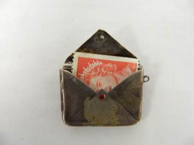
Container Postage Stamps, circa early 1900's
This unique postage stamp container, fashioned as a postal letter is from an era 1800 to early 1900, when items with no real bravado of wealth, were produced to satisfy the basic needs of their owners. A small yet "simple" postage stamp container made from silver would stand out but yet not that "vulgar". This was a period that flouting wealth was not done. This attitude changed when "old" wealth of property and titles moved to industrial and merchant "new" wealth merged.This item was introduced to the Kiewa Valley by a "genteel" woman who had come from "old" wealth in the "mother" country. In rural Australia such flashing of wealth or even "one up man ship" is frowned upon. The Kiewa Valley residents, in this time frame, would have reacted in a "true blue" manner. The significance of this item is that it highlights a time when the "Australian" heart was closely aligned to "mother Great Britain". These national bindings and self identity were only to last until World War II. The realisation of untying the national umbilical chord between Great Britain and Australia came when the United States of America provided its support and a closer bond developed. This container for postal stamps is fashioned as a letter. The lid(flap) is hinged to the main letter frame, allowing access to the contents (stamps). It is made of thin silver (sterling) with the silver markings on the inside of the flap. The folds on the opening flap side mirror the early dated letter envelope (glued on two sides, folded and glued on the third). The markings on the inside, clearly visible when the flap is open has the Assay Office Birmingham "anchor" stamped before the sterling silver "lion" mark. Stamped on inside flap "92" and "M" .Inside the letter facing the opener is the "Anchor" symbol and next to that the "Lion" symbolpostal stamp container, stamps, envelopes -
 Kiewa Valley Historical Society
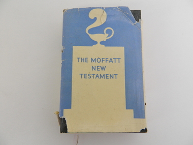
Bible, Bible Moffat, 1935
This Christian Bible by Professor James Moffatt from the United Free Church College in Glasglow Scotland was at a time when translated Christian bibles(Greek to English) were being review as to the accuracy of their translated words. This period was in the early 1900's specifically during and between the two major World Wars of 1914-18 and 1939-45 and also covering the Great Depression(1939). All these periods were ones of death, destruction and "loss of faith". Bibles which provided greater clarity of better times ahead flourished. This book offered its readers hope for the future (in terrible times). The regions that it covered were those who belonged to the Christian Faith. The significance of this bible to the Kiewa Valley is that it provides an insight of those Christians living in a semi remote rural region at the period in Australian history where forces outside of this area were placing hardships which were "foreign" to them, as a family and as a community. The major Christian religions within the Kiewa Valley were either of the Catholic or English Protestant teachings. These groups still remain the dominant ones well into the 2nd Millennium. Spiritual relief to overcome harsh rural setbacks is not just specific to the Australian rural sector but is also global. With the influx of migrant workers from the war torn European nations (after WWII) a broader coverage of Christian and other faiths developed. A "positive" saying, when crops failed and bush fires and river floods sprang up, rallied the faithful "with God's help" This hard covered bible consists of six pages of preamble including title, publishing details, printer and author's preface. The book has 388 pages of black print. Relevant reference lines are notated by numbers on the left side of the page. On the front dust cover is a cream silhouette against a light blue backdrop highlighting a smoking "Aladdin's" Arabic oil lamp on a cenotaph. The hard cover has a embossed emblem of a lantern with a plume of smoke rising from the spout. This is all encapsulated by a circle. The spine also has this emblem. On the dust jacket, front "THE MOFFATT NEW TESTAMENT", and the back cover has blue writing on a cream background. On the spine, at the top "JAMES MOFFATT" below this a white on blue silhouette of "Alalddin's lamp" below this is (in blue letters against a light blue background " THE NEW TESTAMENT A NEW TRANSLATION" On inside cover a signature "Clare Roper". The hard cover has marked in red print "THE NEW TESTAMENT ANEW TRANSLATION MOFFAT" christian bible, prayer, new testament, religion, faith. -
 Kiewa Valley Historical Society
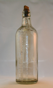
Bottle - Ginger Beer, mid to late 1900's
This bottle was used in a period when "soft" drink ginger beer was "brewed" not only in homes but also in specific breweries. Most rural areas had families which produced their own ginger beer. Medium to large towns and cities had ginger beer "factories". These factories had large "on bottle" advertising who the producer was. This producer advertising was firmly infused into the bottle and not on removable labels (late 1900's on wards). Regional breweries had a strong following, similar to State beer producing breweries. The competition between breweries of ginger beer was regional and not state or international. Return of bottles was not a sign of saving the environment or becoming eco- friendly but a requirement to keep production costs low. This is highlighted by "This bottle Remains the Property", in other words return when empty. Up to the end of the second World War Australian "soft drink" demand was for local produce. The American invasion of other flavours of "soft drink" came in the 1950's. Multi -Corporations producing non alcoholic beverages at lower production costs reduced local manufacturers considerably. This however had little effect on semi isolated rural areas where home brews flourished.This bottle shows the impact that small regional towns had and still have on semi isolated rural communities(Kiewsa Valley). With better communications (radio/television/newspapers) and a better transport connections specialised breweries such as the Wangaratta Brewery had an extensive customer "hinterland" to serve. The "canny" rural population would be able to reuse this bottle for their own specific purpose. Because of the long distances between Kiewa Valley residences and the major towns available to them, the issue of adaptability of any purchases made was always closely linked to their long term usefulness.This bottle is made from thick clear glass and has a capacity of one and a half pints. It has a flat top with a wooden screw stopper (internal thread). On one side "THIS BOTTLE REMAINS THE PROPERTY OF WANGARATTA BREWERY PTY LTD" On the top rim of bottle on both sides "17". On the bottom of the base are "AGM" AND "346"ginger beer bottle, soft drink bottles, cordial bottles, wangaratta drinks -
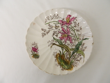 Kiewa Valley Historical Society
Plate - Gilt, 1870 -1920
This gilt plate is from an era where master crockery manufacturers where either located in Britain or Europe.The cost of transportation and the time taken to receive items limited the availability of first class goods. This was an era that was "British is best" in all manufactured goods. With the slow influx of European immigrants European manufactured goods also became of high value. This social requirement was more of a prerequisite for the more affluent rural population, especially at a time when Australia "rode on the sheep's back". Fine British and European goods were a "status symbol", even in rural Australia. After World War II, the invasion of American and Japanese merchandise opened up the market place for cheaper "throw away" items. Longevity and quality of goods fell away as the "throw away" society rolled on.This item demonstrates the time when the rural sector was at its most affluent and influential in dictating the strong ties between Australia, Britain and Europe. The very influential "Country Party" ensured that the protection of the rural sector was well entrenched. The ability of the "well off" rural sector, in this period, were not only able to travel abroad but also to purchase expensive items "overseas" cutlery and crockery. The significance of this item is that it highlights a period in time when the "rural" affluence was at its peak.This hand painted floral gilt plate is a cream fluted china plate decorated with pink and yellow orchid flower arrangement. It is in the "Art Nouveau" period 1880-1920.underneath and within the circular base and in gold freehand script "4" underneath "1562". Pressed into the base is the manufacturer's monogram.Circled around the FAM mark is "* FRANZ ANT. MEHLEM*BONN A/RHEIN*"hand painted china, floral gilt plate, decorative china -
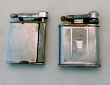 Kiewa Valley Historical Society
Lighter Lift Arm, Circa 1930's to 1940's
This cigarette or pipe lighter was in use in the mid 1900's when the majority of users were men. Ladies did smoke but mainly not in "public" The activity was still regarded as a male activity. Middle to Upper "Class" of women nearly always had a gentleman "at hand" that would "light up" her cigarette. This was seen as a "social" activity only but later in the mid 1900's onward it was quite acceptable for both sexes to "smoke" at anytime.This type of lighter was male orientated due to the degree of lighting the flint with the horizontal movement required a strong thumb action across the lighting wheel. It is significant to rural areas such as the Kiewa Valley as the majority of men (especially during and after World War II) regarded smoking as a way to ease off the "tension" of hard work. The socio-economics of the Australian work place changed after the emancipation of women in the "workforce" after the World War II depleted the male workforce for the duration of the War and changed the Australian ethics of women in all aspects of both city and rural working "so called" male only occupations.This Polo Swift lift arm cigarette/pipe lighter has a chrome plated shell and is fueled by petrol. To operate this lighter you lift the "snuffer" arm exposing the wick, then scrape the flint wheel to create a spark from the adjacent flint(resting on the brass ignition wheel).At the bottom of the lift arm station "POLO". Each side of the lighter are "Art Deco line running from the top of the lighter to the bottom. Between these is a rectangular box with "diamond crossed lines"early hand lighters, smoking in the 1930's, cigarette lighter, tobacco, cigerettes, lighter -
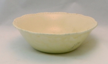 Kiewa Valley Historical Society
Bowl Ceramic, 1955 to 1962
This bowl was imported from "the mother" country (England) in the period when good table ware was either shipped from England or Europe. It was in the period before the American and Asian imports were sought (post World War II and the depression/recession years), when only the best quality kitchenware was preferred and the cheaper mass produced goods were not on the market. The maker's details on the bottom puts the manufacture time between 1955 to 1962.This item, used by one of the Kiewa Valley's oldest established families provides the historical provenance for the item and the period purchased within the time frame when change in the purchasing (in cities) practices from traditional sources, England and Europe was slowly evolving from these sources to cheaper USA and Asian producers. This change however was slower in rural sectors than the cities and larger rural towns. The "traditional" sources was ingrained into the mores of rural sections and changing economic ties with Asia and the USA connected to the greater influx of dinner wares and the cheaper produce. The "throw away" society mores , developed in the USA, after World War II, and transferred to Australia by new technology driven media outlets had a very effective outcome for the demise of quality products from the "mother" country.This buff coloured glazed ceramic bowl was manufactured by an official potter to Her Majesty Queen Victoria. It has a "patterned" top rim but no other details.On the outside bottom the makers seal "Est. 1792" and in a double lined scroll like frame "RIDGEWAY" underneath in smaller print "Made In England".ceramic bowls, kitchen crockery, domestic plates -
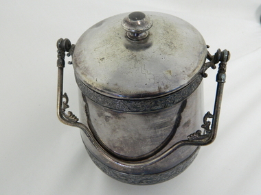 Kiewa Valley Historical Society
Bucket Ice, circa mid 1900's
This mid 1900's ice "bucket" was used during the first major "American" (fashion invasion) of merchandise for the "new " social set. This was a form of release, coming after the tight money restrictions during the "Great Depression" and from World War II.This item is an example of the change of direction in regards to household cutlery and crockery which the Australian rural environment slowly progressed through. This progression was due to a closer alliance with the USA after World War II and and increase push in marketing by USA manufacturers of their Australian partners and the closer alliance between the two nations. The American service men and women on recreational leave during the "South Pacific war" front brought both nations closer together and the requirement of American industries to find new markets resulted in "cheaper" mass produced silverware onto the Australian scene, which at that time were mainly sourced from the UK and Europe. This silver plated "ice bucket" with lid and handle has "pot belly" shape. A smaller circumference top, bulging center and smaller bottom. The lower inside shape of the "bucket" allows for a "grate" to be placed 40mm from the bottom (this grate would separate the "solid" ice cubes from the melted ice water). There is a "U" shaped "swiveled" handle with "art deco" type leaves(grape) reinforcing the cross section. There are two bands of "grape leaf" motifs, one smaller one at the top rim and a larger one on the bottom at the point of furthest bulge.At the outside base is the manufacturers logo "K" and encircled in small print are "KNICKERBOCKER MFG CO. QUADRUPLE PLATE"silver plated ice "bucket", bottle cooler -
 Kiewa Valley Historical Society
Kettle Ceramic, Circa 1950
This electric kettle/Jug is shaped in the style of the Art Deco period 1930's to 1950's (in Australia). It was at the beginning of the wave of creative kitchen ware to stimulate and impress visitors and uplift what used to be a boring kitchen environment.This "art deco" electric kettle is very significant to the Kiewa Valley because it highlight that rural families and areas where in step (fashion wise) to their city "cousins". In the mid 1900's "the fashion" in Australia was (on the whole) always some years behind that of England and Europe. The years after World war II reduced the time lag between the "advanced fashion" of Europe and England and came in step with the emerging modern American fashion. American "film stars" started have their fashion projected onto the silver screens.This electric Fowler ware is a ceramic hot water jug. Its shape is in the "Art Deco" style of the early 1920's.On base "240V - 1650W" below this "AC ONLY" below this "MODEL No. EEJ" "APP. No. N550" below this "JUG BODY BY" under this and in script style "FOWLER WARE" below this "1583"kitchen appliances, tea/coffee preparation, light refreshments, hospitality offerings, art deco styles in appliances -
 Kiewa Valley Historical Society
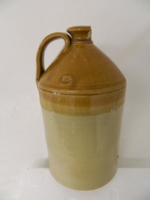
Jar/ Demi John Stone Ware, Circa 1860
This kiln glazed container for liquid's, was the type used in the 1700's to mid 1900's to contain fluids mainly for human consumption which needed to retain liquid that could be affected by sunlight and or required to be maintained at a cooler temperatures. Ginger beer and other "brews" for human consumption were the prime target. The ability to refill these vessels were of the utmost importance to the consumer. Over time these containers were reduced in size and produced for "special" liquids e.g. alcoholic Port. This Demi John stone ware was manufactured in Tamworth (England) and imported into Australia during a period when the majority of "quality" domestic items were sourced from "the Mother Country" and the ties between the still "colonial" outpost were very strong. This bondage remained longer in rural communities than in the cities. The "multi-culturalism of the post World War II era resulted in the lessening of the earlier ties. The growing of nationalism, the Aussie evolution, was brought about by the increased social and business/commercial interactions between Australia and the United States of America, post World War II.This container(jug) is very significant to the Kiewa Valley, a rural region that required these type of liquid storage vessels, especially in the late 1800's to the mid 1900's. These were times when household refrigeration, if available, would be from the "block ice" coolers or "cool" storage nooks and crannies within farmhouse locations.This large "stone ware" glazed Demi John, alias Carboy has a capacity of over 20 litres. It has a conical smooth lipped neck top with a wide, flat(three to four finger) carry and poring handle. The top third portion of the jug is caramel in colour and the bottom a darker cream. It has a manufacturer's seal stamped into the surface before glazing. This item would have been corked and then sealed (air tight) with wax.manufacturer's seal "GEORGE SKEY WILNECOTE TAMWORTH"household liquid jar container, 1800's food storage, kiln fired glazed pottery -
 Kiewa Valley Historical Society
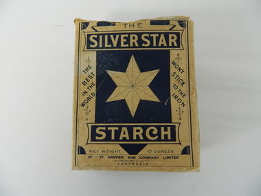
Box Starch, Pre decimal currency date(14th February 1966)
This brand of starch was first manufactured before 1966 and covered the period when Australian made was the preferred clothing due to limited imports from England. This was a period when the demand for "home grown" produce was at its peak. This was in a time when by necessity and ease of supply and not by the "Buy Australian" campaign (of later years), was the major factor for the demand of these type of laundry goods. It was in a time when starch was used in formal clothing to put a "crisp" or fresh new appearance for clothes. This product was in the era and importantly the social more of "clothes make the person" in which starched shirts and dresses was the fashion vogue. Formality of dress was a strictly British "class" up-man-ship which from the 1950's onwards became less and less visible. The Australian "Ocker" or fair "dink'm" bloke became more entrenched after World War II. The national identity was slowly developing.This box of starch is very relevant to the Kiewa Valley because this box highlights the differences ,in this period, between city and rural social standards. Rural areas were deeply entrenched into colonial and the pioneer family structure viz- a-vie social and dress fashion standards. British values and norms lingered on well beyond the changes happening in city fashion. Tradition and English "ties" were the backbone of early colonies and it was only after World War II that these "ties" were becoming irrelevant. Early traditions lingered well past the independence sought by Federation, colony to statehood and trade with other nations eg. USA and Asia. The idea that a change in "status" would automatically change the social mores of Australians, especially in rural ares, was not fully grasped by the "law makers" and those wanting change.This box (capacity 12 ozs) has white(aged into cream) and blue printing and a "white star" on five sides, the sixth side has a laundry scene with two ladies, in early 1900's fashion. The package is made from 200 gsm thick cardboard. As manufacture was made before and during the two World Wars 1914 to 1945 the promotion was heavily focused on Australian made and Australian grown maize. One side of the box has instructions of use and all the other sides are promotional, detailing "the best in the world and won't stick to the iron""SILVER STAR", "THE BEST IN THE WORLD", "WON'T STICK TO THE IRON", "REQUIRES NO BOILING", INSTRUCTIONS FOR USE", "ROBERT HARPER AND COMPANY LIMITED", "INCORPORATED IN VICTORIA, AUSTRALIA", "NET WEIGHT 12 OUNCES", "LARGE BOX 12 OZS"domestic laundry essentials, cotton clothing preparations, household starch "crisp and neat appearances. -
 Eltham District Historical Society Inc
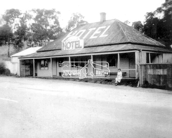
Photograph, Daughter of the owner, Miss Irene Browne, sitting on the verandah of the Lower Plenty Hotel, c.1940-c.1943
Sidney and Ivy-Jane Browne purchased the Lower Plenty ‘Golf Club’ Hotel in 1940. They owned it until 1943. Their daughter, Irene Stella, was born in Eltham in July 1923 and would have been between 17 and 20 years of age at the time this photograph was taken. Ivy-Jane (nee Williams) was born in Eltham in December 1899 and was the sister of George Alfred Williams who is commemorated on the WWI plaque at the back of St. Margaret’s church, Eltham, and whose name is also listed on the Cenotaph in front of the Eltham War Memorial in Main Road, Eltham. Irene Browne married Leslie Allan Walker in 1945 and following his death in 1958 she married Charles William Smith. She died in 2008 and is buried in Omeo Cemetery along with her husband, Charles Smith. Her granddaughter, Veronica Gunn, advises a few years earlier, Irene’s son took her to the hotel and spoke with the then owner who showed Irene the photo, which she confirmed was of herself. Digital filelower plenty, lower plenty hotel, hotels, irene stella browne, irene stella smith, golf club hotel, 1940s -
 Eltham District Historical Society Inc
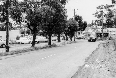
Photograph, Looking north along the east side of Main Road from near Henry Street, Eltham, February 1968, Feb 1968
Shows the Commercial Bank of Australia on the Dudley Street intersection and part of the War Memorial on the left amongst the parked cars.In February 1968 an unknown person took a series of photos from the Eltham Hotel at Pitt Street heading north along Main Road through the shopping centre to just north of Elsa Court covering the length of the section of Main Road which was duplicated shortly thereafter. Shows the condition and environment of the streesscape of Main Road, Eltham immediately prior to the duplication between Pitt Street and Elsa Court through the shopping centre. Also shows a number of shops and businesses that operated at that time.Black and white photographduplication, eltham, main road, commercial bank, eltham, dudley street, shire of eltham war memorial, arthur street, shopping centre, eltham shire office -
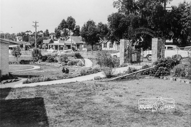 Eltham District Historical Society Inc
Photograph, Inside the garden of the War memorial with paths and entrance gates along Main Road, Eltham, February 1968, Feb 1968
Shows the east side shops between Arthur Street and Dudley Street and former Eltham Shire Offices. View is from the entrance of the Baby Health Centre. The roadway outside the gates was not made and was used for parking. The shops and an early fire station (near to left gate post) show the area before the Woolworths rebuilding of the area to Eltham.In February 1968 an unknown person took a series of photos from the Eltham Hotel at Pitt Street heading north along Main Road through the shopping centre to just north of Elsa Court covering the length of the section of Main Road which was duplicated shortly thereafter. Shows the condition and environment of the streesscape of Main Road, Eltham immediately prior to the duplication between Pitt Street and Elsa Court through the shopping centre. Also shows a number of shops and businesses that operated at that time.Black and white photographduplication, eltham, main road, dudley street, shire of eltham war memorial, arthur street, shopping centre, eltham shire office