Showing 914 items
matching directories
-
 Melbourne Tram Museum
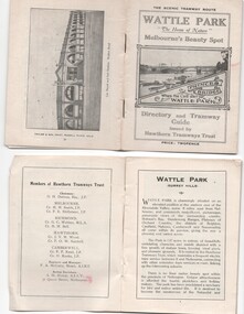
Ephemera - Timetable, Hawthorn Tramways Trust (HTT), "Directory and Tramway Guide issued by the Hawthorn Tramways Trust", 1918
Booklet - 38 pages, printed on off white page, centre stapled, titled "Directory and Tramway Guide issued by the Hawthorn Tramways Trust", specifically advertising Wattle Park and showing Princes Bridge and the Yarra on the front cover and a photo of Hawthorn depot on the rear cover. Gives details of Wattle Park, its opening, many photos, members of the Trust, Engineer and Manager and Acting Secretary, Stopping points for the round and fares to Wattle Park, section fares, maps of the tram routes and connections with other tramways and railway stations. Has timetables for Burnley and other major points, special and emergency services, the coloured lights used on the trams, and a map for land sales at Riversdale Heights estate. Advertisements for Mutual stores, Melbourne Electric Supply Co., Moule, Hamilton and Kindle for the sale of land at Riversdale Heights and a map showing the estate location. Both copies have alterations or corrections to the route signage letters - marked in red - from the Minutes of the HTT Board meetings, the Trust were not happy with the finished product and was reluctant to pay for them - see Minutes of Meeting No. 99 of 5-7-1918. Two copies held - one with red marks on the front cover.trams, tramways, htt, wattle park, princes bridge, hawthorn depot, timetables, mesco, real estate -
 Ringwood and District Historical Society
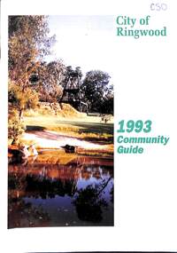
Book, City of Ringwood, City of Ringwood 1993 Community Guide, 1993
Community information book issued by City of Ringwood for 1993 - covering the facilities and activities of the Ringwood Council and other local organisations and associations. Includes two Ringwood Aquatic Centre bonus entry vouchers valid until June 30th, 1993. Cover photographs: Front - Poppet Head, Ringwood Lake; Back - Opening of North Ringwood Child Care Centre. CONTENTS: (page no.) Message from the Mayor – Cr. Greg Adkins, J.P. 3 Councillors 4 Council & Committee Cycle 5 Council Elections 6 History of Ringwood 7 Chief Executive's Report 8 The Management Team 9 Functional Responsibilities 10 Community Liaison 11 Council Expenditure for 1992/93 12 Rates and Valuations 13 COUNCIL SERVICES Community Services 14 Protecting the Environment 17 Protecting Our Community 19 Town Planning 21 Building 22 Design and Investigation 23 Works 24 Street Index - Electoral Wards 25 Neighbourhood Map 26 and 27 COUNCIL RECREAION AND LEISURE FACILITIES Ringwood Golf Course 29 Aquatic Centre 30 The Ringwood Convention Centre 32 Ringwood Library 34 Ringwood Recreation 35 Parks and Reserves 30 Community Directory 38-50 Community Information Data Bank 51 Aquatic Centre Vouchers 51rinx -
 Melbourne Tram Museum
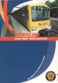
Magazine, Rail Tram & Bus Union (RTBU), "Newsline - 2008 New Year Edition" , "Newsline - 2007 New Year Edition", 2006
.1 - Magazine - A4 - 20 pages including light card covers, full colour, centre stapled titled "Newsline - 2008 New Year Edition", published by the RTBU - Rail Tram and Bus Union Christmas 2007. Contains reports from Union officials including Phil Altieri Assistant Secretary , Lou DiGregorio - Secretary and Doug Brady, President of the Tram and Bus division. Gives contact details. Photos supplied by Yarra Trams and Metlink. Has adverts for Southern Cross Station, Slater & Gordon, Consultum financial advisors, Members Equity bank, Connex, VLine, Metlink, RTBU Holiday units, Mainco, Transport Health Fund, Retired Railway Employees Association of Vic and Retired Tramway Employees Association of Vic. - President Joyce Spark, Secretary Dot Micallef, Yarra trams, Austral Credit Union and a services directory. For Calendar see Reg Item 1182. .2 - as above - 2007 edition, with additional Officers reporting. Has front cover photo of the Siemens 100 years of trams on the front cover, and a poster for the event on the inside front cover. On page 14, has a photo of retired trammies at Essendon Depot during the 100 years celebrations. Has adverts in addition to above for Australian Super, Safeworking solutions (Rail Safety).trams, tramways, yarra trams, rtbu, unions, essendon, 100 years of electric trams -
 Eltham District Historical Society Inc
Document - Appendix, M.B. Watson, Shire Secretary, List of Former Road Board Chairmen and Shire Presidents (1856-1966), 28 Nov 1966
Appendix to Shire Secretary’s Report, 28 November 1966 SHIRE PRESIDENTS Local Government in this part of the State could be said to have commenced with election in 1846 of three trustees for "The Parish Road, leading from the Suburban Allotments in the Parish of Jika Jika, near Melbourne, to the Village Reserve in the Parish of Nillumbik". The Upper Heidelberg and Old Eltham Road follow approximately the original line of road proclaimed in 1840. The Eltham Road District was proclaimed on 24.9.1856. A meeting of landowners and householders of the Eltham Road District was held on 14.10.1856 at the Fountain of Friendship Hotel, Little Eltham, for the purpose of forming a District Road Board. To date I have been unable to locate any record of the names of the members elected, or of the first Chairman. Further research may yield the desired information. The Shire of Eltham was constituted on 28.3.1871. The proposed Roll of Shire Presidents should, I believe, also include the Road Board Chairmen. It may also be considered fitting to recognise the Heidelberg or Nillumbik (or Warringal) Road Trust in the same way. The first Minute Book of the Board, covering the period 1856 to 1863, has apparently been missing for many years. The Shire Minute Book for the period 1878 to 1885 is also missing. The absence of these vital records makes difficult the compilation of a complete and accurate list of Chairmen and Presidents. Although an early letter book yielded the names of the Shire Presidents in 1878, 1879 and 1800. The names prior to 1863 were derived from Rate Books and Government Gazettes. The information contained in the Municipal Directories 1875 to 1885 is at variance to some extent with such Council records as are available for that period, and consequently cannot be relied upon for the years where the Presidents names have not been shown. shire of eltham archives, series listing, a. armstrong, a. beale, a. brinkkotter, a. donaldson, a.h. price, a.j. braid, c.h. bath, c.m.a. pelling (mrs.), c.t. bell, d.c. o'beirne, e.d. butler, e.h. cameron, e.j. andrew, e.p. harmer, f.e. griffith, f.v. squire, f.w. nankervis, g. love, g. robertson, h. dendy, h. hewitt, h. stooke, l.t. wilmot, j. cox, j. murray, j. barr, j. bell, j. fitch, j. herbert, j. lawrey, j. mealy, j. pape, j. ryan, j. smedley, j.b. shallard, j.l. beale, l. c. docksey, r. mcadam, r.a. bell, r.c. white, r.r. woolcott, rutter, s.s. addison, s.w. scott, t. armstrong, t. irvine, w. horris, w. hubbard, w. lorimer, w. morris, w. taylor, w.c. farrell, w.f. ford, w.g. gray, w.h. bradbury, w.j. taylor, w.v. houghton -
 Victorian Aboriginal Corporation for Languages
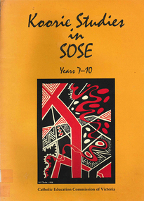
Book, Catholic Education Commission of Victoria, Koorie studies in SOSE : years 7-10, 2001
Section 1. Notes on the use of this resource Section 2. Policy support statements. Aboriginal Studies Policy Statement of Victorian Aboriginal Education Association Incorporated (VAEAI) National Principles and Guidelines for Aboriginal Studies and Torres Strait Islander Studies, K-12 Principles for the Introduction of Aboriginal Perspectives in the Curriculum of the Catholic School (Catholic Education Commission of Victoria Policy 1.3, 1987) Section 3. Language, culture and viewpoint: issues of terminology Section 4. Units of work Unit 1. Koorie people of south-east Australia: a contemporary view Unit 2. On sacred ground Unit 3. Koorie life in the pre-contact era Unit 4. Mulla Meea-Baa Gnuenjall: a long time ago, and today Unit 5. The land we share: human stories in the environment Unit 6. Frontier wars Unit 7. Aboriginal mission stations and reserves in Victoria Unit 8. Land, law and indigenous Australians Section 5. Directory of indigenous organisations and affiliated groups/?agencies. National organisations Victorian organisations Catholic Education Commission of Victoria Indigenous Education personnel Organisations within regions of the Archdiocese of Melbourne Organisations within regions of the Ballarat Diocese Organisations within regions of the Sale Diocese Organisations within regions of the Sandhurst Diocese Cultural centres/?camps across Victoria.maps, b&w photographsvaeai, history, curriculum development, koorie studies, catholic education commission of victoria, secondary school education, -
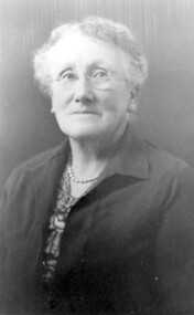 Surrey Hills Historical Society Collection
Photograph, Mrs Florence Margaret Tacey (nee Edwards)
Mrs Florence Margaret Tacey (nee Edwards) was the mother of Albert Arthur Tacey. She was born in 1863; died in 1943 in Camberwell. Her husband was William Tacey born in the Buckland Valley near Bright in 1857. There were many members of the Tacey family who were butchers. Various members of the family were associated with Tacey's Butchers at 629 Canterbury Road, Surrey Hills. According to a Context P/L heritage assessment of the property the land on which the business was built "was purchased by Edward Tacey on 16 September 1889. Edward Tacey was a butcher and the Sands & MacDougall street directory indicates that a butcher’s shop had been constructed on the site and was operating by 1890. It seems that the family lived for some time at a house located next door to the shop at 627 Canterbury Road (visible on the 1909 MMBW plan, but since demolished). On 15 June 1920 Edward Tacey transferred all three blocks of land to Joseph Tacey, most likely his son * and also a butcher, who carried on business from the same premises. Joseph Tacey died on 20 February 1933, after which administration of his estate (which included the three blocks of land) passed to his widow, Mary Dorothy Tacey." Edward Tacey (1863 - 1952) was the brother of William Tacey (1857 - 1920). The property passed to Joseph Charles Tacey (1887 - 1933), his nephew and son of William, not his son. His wife was Mary Dorothy Coates. Albert Arthur Tacey was a brother of Joseph Charles Tacey. The SHNCHC has a large framed photo collage of the Tacey butcher's shop at 629 Canterbury Road. It hung in various Tacey family-owned butcher's shops around Victoria before coming back to Surrey Hills. The donor was the daughter of Albert Arthur Tacey (1902-1959). A black and white photograph of an older lady. She has greying hair, is wearing rimless glasses, pearls and a jacket over her dress.surrey hills, butchers, mrs florence margaret tacey, miss florence margaret edwards, william tacey, joseph charles tacey, albert arthur tacey -
 Ringwood and District Historical Society
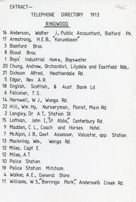
Document, 1913 Ringwood Telephone Directory
One A4 sheetTELEPHONE DIRECTORY 1913 RINGWOOD 16 Anderson, Walter J, Public Accountant, Belford Pk. 17 Armstrong, H.E.B., 'Korumbeen'' 3 Bamford Bros. 8 Blood Bros. 1 Boys' Industrial Home, Bayswater. 20 Chung, Andrew, Orchardist, Lilydale and Eastfield Rds, 21 Dickson Alfred, Heatherdale Rd. 5 Edgar, Rev. A.R. 18 English. Scottish, & Aust. Bank Ld. 6 Falconer, T. S. 14 Harnwell, W.J., Wonga Rd. 22 Hill, Wm.Hy, Nurseryman, Florist, Main Rd. 2 Langley, Or A.T. Station St. 15 Lothian, John I, "St Abbs" Canterbury Rd. 9 Madden, C. L., Coach and Horses Hotel. 7 McAlpin, J. B., Govt. Assessor, Valuator, opp. Station. 13 Mackinlay, Wm., Wonga Rd. 12 Miles, Capt. E. 12 Miles, A.T. 10 Police Station. 19 Police Station. Mitcham. 4 Walker, A.E., General Store. 11 Williams, W.S., 'Berringa Park,' Andersons Creek Rd. -
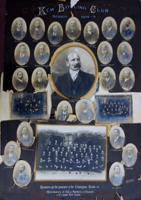 Kew Historical Society Inc
Photograph, Kew Bowling Club, Runners up for Pennant and for Championship Rink; Office Bearers of Club and Members of Pennant and Champion Rink Teams, 1908-9
The Kew Bowling Club was formed in 1880 and merged with Auburn Heights Recreation Club in 1998. In addition to the unnamed members of the teams, the following individuals are profiled on the item. The background of these men has been identified by John Torpey as follows: BRADSHAW William Henry, grocer, 6 Cotham Road, Kew & 33 Prospect Hill Road, Camberwell - CARNEGIE J Lewis, merchant, Studley Avenue, Kew [Carnegie & Sons, piano & organ importers 106 Elizabeth Street, Melbourne] - CLARKE Charles, warehouseman, 35 Queen Street, Kew - EDGAR Robert McCutcheon, 215 High Street, Kew - FINLAYSON John Marshall, solicitor, 178 Cotham Road, Kew - GREEN Charles Henry, clerk, 81 Wellington Street, Kew - GREENHILL F snr [not found] - GREENHILL Thomas jnr, traveller, High Street south, Kew - HAMBLETON Lincoln, civil servant, 32 Coleridge Street, Kew - HANDBURY John, manufacturer, 55 Walpole street, Kew - JELLIS Thomas G, baker, Princess Street, Kew - LILBURN William Hugh solicitor, Denmark Street, Kew - MANSFIELD Allan, plumber, 150 Cotham Road, Kew [S&McD] or 21 Belmont Avenue, Kew [Electoral Roll 1909] - NATHAN Simeon, warehouseman, 59 Sackville Street, Kew - NIVEN Henry N, 192 Barkers Road, Kew [FW Niven & Co 40-42 Flinders Street, Melbourne, printers & lithographers] - SIMONTON Alan Thompson, dairyman, Belmont Avenue, Kew - SINUCH WC [not known – bottom right of frame] - SWINBURNE George [see Australian Dictionary of Biography] - TREDENNICK William, civil servant 285 Tennyson Street, Kew - WENTWORTH William Dalton, painter, 5 Derrick Street, Kew - WOOLLARD Thomas, civil servant, Hildebrand Crescent, Hawthorn - WOOLLARD Walter Herbert, builder, 35 Disraeli Street, Kew [Sources: Sands & McDougall directories, Electoral Roll 1909]The photographic collage is historically important as it includes rare photographs of local identities, many of whom were significant civic actors statewide.Large photo collage created by Barroni & Co (Melb) of team, player and official portraits of members of the Kew Bowling Club. At one stage the item was in a drawer in a map cupboard, fractured into multiple pieces. The items were later assembled some years ago Graham Lindsay and framed in 2021 for exhibition by John Torpey. "Kew Bowling Club / Season 1908-9 / Runners up for pennant and for Championship Rink / Office bearers of Club and Members of Pennant and Champion Rink Teams".kew bowling club -
 Tarnagulla History Archive
Photograph: Colonial Bank of Australasia (later Union Bank) in Tarnagulla, June 1866
David Gordon Collection. There were four banks in Tarnagulla at one stage, but two - the National Bank and the Bank of Australasia - were open for a short period only. The single-storey brick building at far left was built in 1859 and used by the Union Bank until 1888, and was later renamed 'Lochcarron' and used as premises by doctors and dentists. The two-storey building (right) was built in 1866 by the Colonial Bank of Australasia. Before this, the site had been occupied by Foo's shop. Whilst it was being built, the Colonial Bank operated from Company's Hotel (later known as Burstall Hall and the Council Chambers). The double-storey building in this image was used by the Colonial Bank from 1866 until 21st February, 1888. The premises were sold to the Union Bank for £2500. The Union Bank moved in and commenced operations on 6th June 1888, continuing until 1942. The building was later used as a general store until the 1990s. Both buildings are now private residences. This image was created by Aime Marchand in June 1866. Marchand (1846-1910) made a series of fourteen photographs which were submitted to the 1866-67 Melbourne Intercolonial Exhibition, where they earned a 1st Class Honourable Mention. This is one of those fourteen images. Of French or Belgian origin and possibly formerly an assayer in California, Marchand appears to have begun his practice of photography in Tarnagulla around 1865 as an assistant to A.B. Clay. By the following year he had settled in Portland, where he opened the Royal Photographic Studio in Gawler Street. From his base in Portland he toured surrounding districts, offering portrait and view services. Little else is known about his life. He appears to have left Australia in 1878. A misprint of his name in a local directory as Annie Marchand created the misconception that he was one of only a few named women photographers in the colonies. -
 Bendigo Historical Society Inc.
Document - AGOS INFO, BENDIGO, April 1987
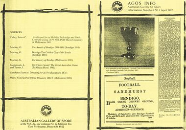
AGOS INFO, Bendigo. Australian Gallery of Sport. Information Pamphlet No. 1 April 1987. Photo of cup awarded to the Sanhurst Football Club for their victory over Bendigo Football Club, 4th July 1883. (Purchased 1987). Extract from Bendigo Advertiser, 4th July 1883 advertising Match between Sandhurst and Bendigo. Admission - Sixpence. Members of Sanhurst & Bendigo Football Clubs and BUCC admitted free on production of tickets. Extract of Bendigo Advertiser, 5th July 1883, FOOTBALL Sandhurst v. Bendigo. (remainder of print too small to read. Sandhurst. Bendigo July 4th 1883 The match played between Sandhurst and Bendigo provides a rare insight into the Australian game at a crucial stage of its development.. . Trophy presented by local jeweler, Mr Joseph Moody. .. Football was relatively weaker in Bendigo than in the comparable city of Ballarat. This can be explained by the high migrant proportion of the Bendigo population, its economic difficulties in the 1880s and by its distance from Melbourne. .. Football overtook cricket by the end of the decade as the most popular sport. .. A regular Saturday competition was played, with matches also played on Wednesdays. These matches were a legacy of the earliest ''scratch'' matches, suggesting a relatively strong union movement which had won concessions for weekend work. Matches started at 3pm. ..The best player on the ground was a contractor and the captain an accountant. .. Transition. The predominance of the ''little mark'' the participation of sometimes frightened junior teams against adults and the division of the game into halves rather than quarters represents an era that has disappeared. Complaints of rough play, poor losers, the problems posed by children. .. An issue, was seen as a blight on the game in 1883. The greatest offender, alleged by ''Drop-Kick'' in The Bendigo Advertiser, was Sheldon of Sandhurst, an ancestor of current day player Ken Sheldon of St Kilda. .. Fundamental issue about the place of sport in society. .. The reason for this is that the Bendigo club was in dispute with the Bendgio Union Cricket Club over control of the Back Creek Ground. If they had been refused the ground, as it was feared, then the whole association would have been forced to disband. Only last minute negotiations resolved the dispute. .. Reflects the values of society, .. Broader conflicts about power and the control of resources within that society. 2000 turned out. The crowd cheered lustily and the players exhibited similar excitement and were urged on by their captains to play up and kick the ball. In the eventual Sanhurst victory, amongst the best players was Edward Cordner, a forerunner of the renowned Cordner family of the Melbourne Football Clubs. Shane Cahill. Sources: Fahey, James C. Wealth and Social Mobility In Bendigo and North Central Victoria, 1868-1891. Mackay, G. The Annals of Bendigo 1868-1891 (Bendigo 1914). Mackay, G. Bendigo The Golden City of the South (Bendigo 1893) Mackay, G. The History of Bendigo (Melbourne 1891). Sandercock, L.. And Turner, I. Up Where Cazaly? The Great Australian Game (St Albans Herts. 1981) Sanhurst Districts' Directory for 1875-6 (Sandhurst 1875) Wise's Victoria Post Office Directory 1884-5 (Melbourne 1886). Australian Gallery Of Sport at the MCG, cnr Joliment St. & Joliment Trc. East Melbourne, Phone 654 8922.clubs and associations, football, agos, agos info, bendigo. australian gallery of sport. information pamphlet no. 1 april 1987. photo cup awarded sanhurst football club for victory bendigo football club, 4th july 1883. (purchased 1987). advertiser, 4th july 1883 match between sandhurst v. bendigo. admission - sixpence. members sanhurst & bendigo football clubs and bucc free. extract, 5th july 1883, football sandhurst v. bendigo. sandhurst. bendigo july 4th 1883 sandhurst and bendigo provides insight into the australian stage development.. . trophy local jeweler, mr joseph moody. .. football weaker in bendigo than in ballarat. explained by the migrant proportion bendigo population, its economic difficulties 1880s distance from melbourne.. football overtook cricket by end decade the popular sport.. saturday competition played, matches also wednesdays. legacy of the earliest ''scratch'' matches, strong union movement concessions for weekend work. matches started at 3pm.. best player on the ground a contractor the captain accountant. .. transition. predominance ''little mark'' participation frightened junior teams adults game halves rather than quarters represents an era disappeared. complaints rough play, poor losers, problems posed children., a blight 1883. offender, ''drop-kick'', sheldon, ancestor ken sheldon of st kilda...bendigo club was in dispute bendgio union cricket club control of the back creek ground. refused, as it was feared, association forced to disband. negotiations resolved dispute..values of society.. conflicts power control resources. 2000 turned out. crowd cheered players exhibited similar excitement captains. edward cordner. cordner family melbourne football clubs. shane cahill. sources: fahey, james c. wealth and social mobility in bendigo and north central victoria, 1868-1891. mackay, g. the annals of bendigo 1868-1891 (bendigo 1914). mackay, g. bendigo the golden city of the south (bendigo 1893) mackay, g. the history of bendigo (melbourne 1891). sandercock, l.. and turner, i. up where cazaly? the great australian game (st albans herts. 1981) sanhurst districts' directory for 1875-6 (sandhurst 1875) wise's victoria post office directory 1884-5 (melbourne 1886). australian gallery of sport at the mcg, cnr joliment st. & joliment trc. east melbourne, phone 654 8922. -
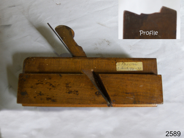
 City of Moorabbin Historical Society (Operating the Box Cottage Museum)
Tools, Spokeshave steel ornate, c1900
A spokeshave is a tool used to shape and smooth wooden rods and shafts - often for use as wheel spokes, chair legs . Spokeshaves can be made from flat-bottom, concave, or convex soles, depending on the type of job to be performed. Spokeshaves can include one or more sharpened notches along which the wooden shaft is pulled in order to shave it down to the proper diameter. Historically, spokeshave blades were made of metal, whilst the body and handles were wood. An early design consisted of a metal blade with a pair of tangs to which the wooden handles were attached. Like a plane, spokeshaves typically have a sole plate that fixes the angle of the blade relative to the surface being worked. By the twentieth century metal handles and detachable blades had become the most common. Preston Tools was an English tool making company also known as E.P. Tools and Edward Preston Tools. Edward Preston Sr. (1805-1883) was first listed as a plane maker at 77 Lichfield Street in the 1833 Birmingham Directory but it is believed he may have started business there as early as 1825. Around 1850 his son, Edward Preston Jr. (1835-1908) left school to join his father's business and he later started up his own "wood and brass spirit level manufactory" at 97-1/2 Lichfield Street by 1864. By 1866 Edward Jr. had added planes, routers, joiners, coach, gun, cabinet and carpenters tools to his line, and the following year he moved his shop from his father's address and relocated to 26 Newton Street, before moving again to a much larger premises at 22-24 Whittall Street. This later became the office and factory of Edward Preston and Sons, who were forced to liquidate in 1934, due mainly to the Great Depression and mismanagement of the company. The plane making concern was sold to the Sheffield firm of C. & J. Hampton, who had subsequently merged in 1932 with Record Ridgeway Ltd.An ornate steel spokeshave wood plane with an adjustable screw.PRESTONS PATENTwoodwork, tools, spokeshave, moorabbin, cheltenham, bentleigh, early settlers, pioneers, market gardeners, woodplanes, craftwork, bicycle wheels, furniture, cabinetmaking, cartwheels, wagons, drays, preston edward, preston tools ltd -
 Surrey Hills Historical Society Collection
Work on paper - Vertical file, Kew State electorate
Collected materials mainly produced by the local member and candidates for election.A standard vertical file with attached pp pockets which contain: 1. How to vote card 2022, Kew Legislative Assembly, Kooyong Climate Change Alliance 2. How to vote flyer 2022 for The Greens; Jackie Carter; Katherine Copsey 3. Election flyer from Sophie Torney (Independent), dated 20/10/2022 4. Election flyer from Sophie Torney, (Independent), dated 31/10/2022 5. How to vote flyer, Sophie Torney (Independent) 2022 6. How to vote flyer, Lucy Skelton (ALP) 2022 7. Election flyer, Jess Wilson (Liberal) 2022 – “We will …” 8. Election flyer, Jess Wilson (Liberal) 2022 – “Getting things done for Kew” – 2 copies 9. Election flyer from Liberal Party against Teals, dated 27/10/2022 – 2 copies 10. Election flyer – Vote Liberal on both ballot papers 2022 11. Election flyer from Jess Wilson (Liberal) – My plan for Kew, dated 16/11/2022 12. Local directory card from Jess Wilson, Member for Kew 13. Election flyer, Animal Justice Party, 2022 14. Election flyer from Jess Wilson – Only the Liberals will fix Victoria’s healthcare …, 2022 15. Jess Wilson Community News, Spring 2023 16. Jess Wilson Community News, Autumn 2023 – 2 copies 17. Jess Wilson Inaugural Speech, 7 February 2023 18. Jess Wilson Community News, Winter 2024 – 2 copies SHVFKEWST on top RH corner of the suspension filekooyong climate change alliance, jackie carter, katherine copsey, animal justice party, 2022, sophey torney, jess wilson, 2023, 2024, elections, how to vote cards, lucy skelton, jess wilson inaugural speech -
 Flagstaff Hill Maritime Museum and Village
Ceramic - Stoneware Bottle, Henry Kennedy Pottery, Late 1800s to early 1900s
This bottle was made in Scotland and recovered decades later from a shipwreck along the coast of Victoria. It may have been amongst the ship's cargo, its provisions or amongst a passenger's personal luggage. It is now part of the John Chance collection. Stoneware bottles similar to this one were in common use during the mid-to-late 19th century. They were used to store and transport. The bottles were handmade using either a potter's wheel or in moulds such as a plaster mould, which gave the bottles uniformity in size and shape. The bottle would then be fired and glazed in a hot kiln. Makers often identified their bottles with the impression of a small symbol or adding a colour to the mouth. The manufacturer usually stamped their bottles with their name and logo, and sometimes a message that the bottle remained their property and should be returned to them. The bottles could then be cleaned and refilled. The Barrowfield pottery was founded in 1866 by Henry Kennedy, an Irish native, in the Camlachie district east of Glasgow, close to the Campbellfield and Mount Blue potteries. It is believed that Kennedy started with just one kiln but by 1871 was employing forty men and six boys and such was the success of the enterprise that by 1880, no less than eight kilns were in operation and a year later one hundred and the pottery was employing eighteen people. Stoneware bottle production was a mainstay of the pottery and over “1500 dozen” were being turned out daily along with other wares, including 30-gallon ironstone containers. With so many kilns in operation, six hundred saggars were required every week but, unlike some potteries, these were made on the premises from Garnkirk and Glenboig fire clays. Pottery production reaches a high scale which presented a high risk of fire and Barrowfield was no exception. In April 1884 heat from a kiln set fire to the roof resulting in significant structural damage, the loss of unfinished wares alone amounting to £10,000 a very substantial sum in 1884. The pottery recovered from this reverse but then Henry Kennedy died in July 1890. The terms of his will indicated that he and his sons John and Joseph were partners and this was reflected in a change of title in the 1891-92 Post Office Directory to Henry Kennedy & Sons. Despite the growth of the business there was still space enough, however, to allow china, earthenware and glass retailers Daniel and John McDougall to commence production of their Nautilus wares there in 1894, the success of which allowed them to soon move to permanent quarters at the empty Saracen Pottery, Possil. In around 1900 John Kennedy left to resurrect the liquidated Cleland Pottery and although Barrowfield remained listed as Henry Kennedy & Sons, brother Joseph was in control. In 1911 Henry Kennedy & Sons Ltd was formed, with two of the four directors being the Kennedy brothers. The pottery’s growth to this point was reflected in the eighteen kilns the largest pottery kilns then recorded in Scotland. However, the disruption of the First World War and the combined effects of subsequent economic depression, US prohibition, hygiene regulations and competition from alternative materials posed severe challenges for stoneware potteries in the post-war years as they competed with each other for diminishing markets. Competitors such as Eagle and Caledonian Potteries fell by the wayside and finally, Barrowfield closed in 1929. This stoneware bottle is historically significant for its manufacture and use in the late 19th to the early 20th century. The bottle is also significant as it was recovered by John Chance, a diver, from a wreck on the coast of Victoria in the 1960s-70s. Items that come from several wrecks along Victoria's coast have since been donated to the Flagstaff Hill Maritime Village’s museum collection by his family, illustrating this item’s level of historical value. Stoneware was produced at Barrowfield pottery for the domestic and export markets, with South America being a large market. Barrowfield stoneware can be found throughout the world. Its longevity and abundant production makes the subject item a significant addition to the Flagstaff Hill Maritime Museum collection.Bottle, salt glazed stoneware, beige, some discolouration above base. Chip on base and on neck. Inscriptions stamped near base.Makers lozenge stamped, H Kennedy Barrowfield Pottery GLASGOW at base.flagstaff hill, warrnambool, flagstaff hill maritime museum, maritime museum, shipwreck coast, flagstaff hill maritime village, great ocean road, john chance, h kennedy pottery, stoneware, ironstone, pottery, barrowfield glasgow -
Surrey Hills Historical Society Collection
Work on paper - Bakeries in Surrey Hills
A vertical file with the following items: 1. Bakers in Surrey Hills from Sands and Mac’s directories 1885-1960s (1 page). 2. Bakers in Surrey Hills at 108 and 118 Union Road, 1900-1950 (1 page). 3. M.F. Conlan’s new bakery, Box Hill Reporter, 3.1.1930 (1 page). 4. M.F. Conlan – bakery 410-412 Canterbury Road, note from Miss E. Conlan (undated) (1 page). 5. 108 Union Road history, prepared by Lisa Gave, March, 1997 (2 pages). 6. Bakery – Slavin: undated notes on G.I. Garner & M. Conlan by Mrs. E. Sneddon (1 page). 7. ‘Conlan’s bakery’ by Eileen Conlan for a talk at S.H Neighbourhood Centre, 1985, (2 pages with 3rd answers to questions). 8. Advertisement ‘Conlan’s bread’, The Argus, 24.2.1933 (NLA) (1 page). 9. Bakery 118 Union Road various notes 1890-1980 (1 typed and 1 handwritten page). 10. Russell Slavin death notice, 31.1.2001 (1 page). 11. 2 photos, back to back, of baking equipment made by Joseph Baker and sons (unknown newspaper) (1 page). 12. Rowe family information, 2004 (1 page). 13. ‘New ways for cake fillings and frostings’ compiled by Davis Gelatine (Australia) Pty. Ltd. (undated) (1 page folded into booklet). 14. ‘Diabetic recipes’ compiled by Davis Gelatine (undated) (32 page booklet & covers). 15. Catering competition held by the Victorian Master Pastrycooks’ Association: prize awarded to D.H. Rowe July, 1938 (1 page). 16. 2 photocopies of no. 11 (2 pages). 17. Edible Oil Industries Pty. Ltd. Bakery service department 14 recipes (undated) (14 pages). 18. The E.O.I. bakery service Kaykee 10 minute mixing method (undated) (1 page). 19. Casely’s ice block mixes (undated) (15 page booklet & cover). 20. Imperial Margarine Digest, October, 1942, W. Angliss & Co. (Aust.) Pty. Ltd. (1 page). 21. Imperial Margarine Digest, July, 1942, W. Angliss & Co. (Aust.) Pty. Ltd. (1 page). 22. Nycander & Co. Pty. Ltd. Bun recipes, (3 page booklet). 23. ’Bakery focal point of festival’, Progress Press, 12.4.1999 (1 page). 24. Pure Bread Bakery – business card for Terry Seaman (undated) (1 page). bakeries, recipes, 118 union road, 108 union road, lisa gave, m f conlon, 410-412 canterbury road, eileen conlon, g i garner, conlon's bakery, russell slavin, joseph baker and sons, rowe family, davis gelatine (australia) pty. ltd, victorian master pastrycooks’ association, d h rowe, edible oil industries pty ltd, casely's ice block mixes, imperial margarine digest, nycander & co pty ltd, terry seaman, pure bread bakery -
 Eltham District Historical Society Inc
Photograph, Nicholes Photographers, Bird family, c.1905
Bird family, c.1905 Back row, L-R: Janet Bird (nee Kilpatrick), George Bird, Ellen May (Nell) Bird Front row L-R: George Hugh Bird, Ernest Reginald Bird, Arthur Andrew Bird, Edwin John Bird Nicholes Photographer, Alphington According to the Sands McDougall Melbourne Directory, George. Nicholes, Photographer was first listed on the north side of Heidelberg Road, Alphington in 1904 and again in 1905. By 1906 he was still listed but with no profession. From 1907 on he was listed as a bicycle agent. On July 23, 1878, George Bird married Janet Kilpatrick (born Ayrshire) at Northcote by Presbyterian minister, Duncan Fraser. The witnesses were daughters of the minister. George gave his profession as farmer. Around 1880 or possibly earlier he acquired the property known as View Hill at the top of Pitt Street, Eltham between Pitt Street and Mount Pleasant Road and what is now Eucalyptus Road. George and Janet developed an orchard and farm around the View Hill home and had 10 children, three of whom died young. George Bird is listed in the 1977 history of the Eltham Methodist Church as Steward and trustee in the early years. In the 1950 history he is mentioned as Sunday School Superintendent. In the early 1900s, Janet regularly went to the church by horse and jinker. Janet died September 2, 1915, age 60 of endocarditis and bronchial pneumonia. At about this time, three children had married (Sarah, George and Ada) and four were living at home. However, Edwin joined the AIF in August 1915 and Ellen married in 1916 leaving two sons, Arthur and Reg, to look after their father and the property although some of the married children may have lived at View Hill for some time. From Edwin's letters, Hilda Pepper, a cousin on their mother's side) stayed with the family for some time to help. In later years, George developed glaucoma and became blind. He died December 6, 1920, aged 75 years, of diabetes mellites. Both Janet and George are buried at Eltham Cemetery, but the gravestone incorrectly gives 1921 for the death of George. The estate was divided into equal portions and distributed to the surviving members with Arthur and Ted Pepper being Executors. Ada Janet Lowe received a portion above what is now Rockliffe Street and Sis Pepper (Sarah Ann nee Bird) the portion below Rockliffe Street. Ernest Pepper built in the 1930s on the Pepper block at the Pitt Street end. George's share was along Wattle Grove and Arthur received the portion at the eastern end. Presumably the other two received portions including the top of the hill and slopes down to Pitt Street, Mount Pleasant Road and Wattle Grove. Read's (at the corner of Pitt Street and View Hill Crescent) was the first additional house brought in on wheels by a Mr Walkenden. The View Hill house was occupied by the Johanssons in the 1930s and was later damaged by fire. Source: Info provided to Marg Ball by Neil and Lyn Pepper (both deceased) abt. 2018. PANEL 1875-1920 Panels began to be produced around 1875, and were particularly suited, because of their larger size, for capturing family, or even larger, groups. They measured 8.5 by 6.5 inches (22 cm x 16.5 cm). - Frost, Lenore; Dating Family Photos 1850-1920; Valiant Press Pty. Ltd., Berwick, Victoria 1991marg ball collection, 1905, arthur andrew bird, bird family, edwin john bird, ellen may (nell) bird, ernest reginald bird, george bird (1845-1921), george hugh bird, janet bird (nee kilpatrick), nicholes photographer alphington, straw boater -
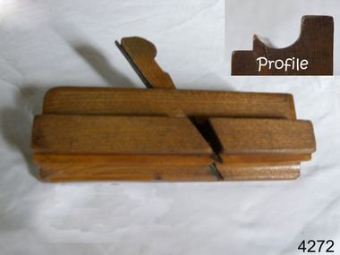
 Flagstaff Hill Maritime Museum and Village
Tool - Wood moulding Plane, Edward Preston & Sons, Early 20th century
By the end of the nineteenth century, the firm of Edward Preston & Sons was founded in 1825, becoming one of England's leading makers of hand tools and in many ways a British counterpart to America's "Stanley" for its wide range of quality utilitarian tools at affordable prices. Edward Preston Sr. (1798–1883) was first listed as a plane-maker at 77 Lichfield Street in the Birmingham Directory of 1833, but later listings and advertisements assert that the business was started in 1825. Preston is likewise recorded as a plane-maker living with his family in Lichfield Street in the 1841 census, at which time his younger son Edward was 6 years old. Around 1850, his son Edward left school to join his father's business and is recorded in the 1851 census as a plane-maker at his father's address. He appears to have been quite a talented and resourceful young man, as he had later been able to start up his own "wood and brass spirit level manufacturing business at 97½ Lichfield Street by 1864. By 1866, Edward Jnr had added planes, routers, joiners, coach, gun, cabinet, and carpenters tools to his line, and the following year he moved his shop from his father's address and relocated to 26 Newton Street, before moving again to much larger premises at 22–24 Whittall Street. This location became known as the Whittall Works and later was the office and factory of Edward Preston & Sons, Ltd. In 1889 Edward Preston Jnr and his three sons were brought into the firm and the name was changed to Edward Preston & Sons, becoming Edward Preston & Sons Ltd on incorporation in 1898. Part of the firm's output was a healthy line of malleable and gun-metal planes and patent adjustable iron smoothers, shoulder planes, bull-nose, and block planes - a range that was expanded in later years. The 1901 catalog shows several styles of planes that were unique to the Preston brand, along with the usual styles which had already been set by other makers. The death of Edward Preston Jnr was reported in the Lichfield Mercury of 26 September 1913. "Mr. Preston was decided of an innovative turn of mind," the newspaper wrote, "as many of the machines in use at his works, as well as of the tools produced were the invention of himself and his three sons, who now manage the business." The report noted that at the time of his death, the business was carried on at Whittall Works, Cheston Street, Aston, Birmingham. Falling on hard times, the firm of Edward Preston & Sons was sold to the Birmingham firm of John Rabone & Sons in 1932, and shortly thereafter manufacturing rights to some of the Preston range of planes were sold to the Sheffield firm of C. & J. Hampton, who would later merge with the Record Tool Company. Some of the Preston planes were directly added to the Record line by the Hampton firm, while others were modified or discontinued altogether. Generally, all Preston wooden planes are stamped on the front of the plane, the shape, size, and character type of the stamp indicating the age of the plane. On some metal planes, all the parts were stamped with a number or symbol during manufacture. This number was used to re-assemble the parts following a batch process. Not all Preston tools are trade-marked clearly. Early shoulder, rebate, chariot planes, and chamfer rebates commonly appear without trademarks but may have assembly numbers. The "E P" trade-mark was already in use by 1882. The trade-mark "Preston" also appears on some later tools that were manufactured in Sheffield, England. These are generally smoothing planes and appear modern and very similar in construction to other modern manufacturers' planes.The item gives a snapshot of one of England's premier tool manufacturing companies at a time when significant industrial changes were occurring in manufacturing and business structures in the World that were beginning to affect social changes.Ogee moulding Plane Maker E Preston & Sons sticker with date 1904 -1931flagstaff hill, warrnambool, shipwrecked-coast, flagstaff-hill, flagstaff-hill-maritime-museum, maritime-museum, shipwreck-coast, flagstaff-hill-maritime-village -
 Flagstaff Hill Maritime Museum and Village
Functional object - Rowlock, early 20th century
This row lock was fitted onto the Warrnambool Lifeboat, which is also on-site at Flagstaff Hill Maritime Village. The construction of the lifeboat 'Warrnambool' began 15th September 1909 and was completed almost 12 months later 1st September 1910. It was built at the Government Dockyard in Williamstown, Victoria, along the lines designed by Great Britain's Royal Lifeboat Institution, and included whale back decks fore and aft, mast and centre board, and rudder and tiller hung from the stern post. It could be propelled by both sail and oar. At that time Captain Ferguson was Chief Harbour Master and Mr Beagley was a foreman boat builder. Mr Beagley built the lifeboat with his fellow workmen. It had all the latest improvements in shape, disposition of weight with watertight compartments, and it had space for a large number of people in addition to the crew. It appears that 'H Meiers' whose signature was on the plaque that was found concealed in the hull, was involved with the building of the lifeboat. His signature and the dates of the start and finish of the boat's construction are penciled on the raw timber 'plaque' found in the hull in the early 1990s when the lifeboat was being restored. It is interesting that the 'Melbourne Directory' of 1911, published by Sands and MacDougal, lists McAuley and Meiers, boat builders, Nelson Place foreshore, between Pasco and Parker Streets, Williamstown, It is quite possibly the business of the person whose name is inscribed on the lifeboat plaque. Flagstaff Hill's documentation also mentions that the keel was laid at 'Harry Myers, boat builders, Williamstown, Melbourne the name 'Myers' can also be spelled 'Meiers', which could be the same person as the Meiers in "McAuley and Meiers" (as mentioned in genealogy lines of Myers). The new lifeboat, to be named 'Warrnambool' was brought to town by train and launched at the breakwater on 1st March 1911 using the Titan crane (the old lifeboat built-in 1858, was then returned to Melbourne in 1911). This new lifeboat was stationed at Warrnambool in a shed located at the base of the Breakwater, adjacent to the slipway. The lifeboat ‘Warrnambool’ was similar in size to the old lifeboat but far superior in design, with new sea-going qualities such as greater maneuverability. The ‘self-righting, self-draining’ design was made the vessel difficult to capsize and even if the boat overturned it would right itself to an even keel and the water would drain away. The hull was built of New Zealand Kauri, using double diagonal planking, laid in two layers at right angles, with a layer of canvas and red lead paint between the timbers to help seal the planking. It has plenty of free board. The backbone timbers were made of Jarrah. The Warrnambool lifeboat was one of several rescue boats used at Port Fairy and Warrnambool in the early 1900s. In late 1914 the Warrnambool lifeboat and crew were used to help find what was left of the tragic wreckage of the Antares and were able to discover the body of one of the crewmen. Between 1951 and 1954 the lifeboat was manned under the guidance of Captain Carrington. He held lifeboat practice each month on a Sunday morning, to comply with the Ports and Harbour’s request that lifeboats be ready for action in case of an emergency. In the early 1960’s it ended its service as a lifeboat and was used in Port Fairy as a barge to help dredge the Moyne River. Flagstaff Hill obtained the Warrnambool lifeboat in 1975. In 1984 it was on display at Flagstaff Hill Maritime Village, Warrnambool. On 23rd May 1990, she was lifted from the water and placed in a cradle for restoration. The name 'WARRNAMBOOL could be seen faintly on the lifeboat before it was restored. It was during the restoration that Flagstaff Hill's boat builder discovered the 'plaque' inside the hull. A copy of the blueprint plans has the name “V.E.E. Gotch” printed on it. His advertisement in Footscray’s ‘Independent’ newspaper of Saturday 11th May 1901 states he is “Principal and Skilled member (Naval Architect) to the Court of Marine Inquiry of Victoria and holds classes for naval architectural drawing and arithmetic.” The subject row lock is significant due to its association the Warrnambool Lifeboat which was an integral part of an important service to the local community as a lifesaving vessel for a half-century. One of the lifeboats many achievements was when it was used to help retrieve the body of a shipwrecked crew member of the ship Antares. Rowlock from the Warrnambool Lifeboat.Noneflagstaff hill, warrnambool, shipwrecked-coast, flagstaff-hill, flagstaff-hill-maritime-museum, maritime-museum, shipwreck-coast, flagstaff-hill-maritime-village, lifeboat warrnambool, life boat, life saving vessel, 1910 vessel, port fairy, boat builder plaque, rescue boat, beagley, government dockyard, williamstown, v.e.e. gotch, royal lifeboat institution, captain ferguson, non-capsizeable lifeboat, self-righting lifeboat, antares shipwreck, double diagonal planking, captain carrington, rowlock, lifeboat rowlock -
 Flagstaff Hill Maritime Museum and Village
Tool - Wood moulding Plane, Edward Preston & Sons, Early 20th century
By the end of the nineteenth century, the firm of Edward Preston & Sons was founded in 1825, becoming one of England's leading makers of hand tools and in many ways a British counterpart to America's "Stanley" for its wide range of quality utilitarian tools at affordable prices. Edward Preston Sr. (1798–1883) was first listed as a plane-maker at 77 Lichfield Street in the Birmingham Directory of 1833, but later listings and advertisements assert that the business was started in 1825. Preston is likewise recorded as a plane-maker living with his family in Lichfield Street in the 1841 census, at which time his younger son Edward was 6 years old. Around 1850, his son Edward left school to join his father's business and is recorded in the 1851 census as a plane-maker at his father's address. He appears to have been quite a talented and resourceful young man, as he had later been able to start up his own "wood and brass spirit level manufacturing business at 97½ Lichfield Street by 1864. By 1866, Edward Jnr had added planes, routers, joiners, coach, gun, cabinet, and carpenters tools to his line, and the following year he moved his shop from his father's address and relocated to 26 Newton Street, before moving again to much larger premises at 22–24 Whittall Street. This location became known as the Whittall Works and later was the office and factory of Edward Preston & Sons, Ltd. In 1889 Edward Preston Jnr and his three sons were brought into the firm and the name was changed to Edward Preston & Sons, becoming Edward Preston & Sons Ltd on incorporation in 1898. Part of the firm's output was a healthy line of malleable and gun-metal planes and patent adjustable iron smoothers, shoulder planes, bull-nose, and block planes - a range that was expanded in later years. The 1901 catalog shows several styles of planes that were unique to the Preston brand, along with the usual styles which had already been set by other makers. The death of Edward Preston Jnr was reported in the Lichfield Mercury of 26 September 1913. "Mr. Preston was decided of an innovative turn of mind," the newspaper wrote, "as many of the machines in use at his works, as well as of the tools produced were the invention of himself and his three sons, who now manage the business." The report noted that at the time of his death, the business was carried on at Whittall Works, Cheston Street, Aston, Birmingham. Falling on hard times, the firm of Edward Preston & Sons was sold to the Birmingham firm of John Rabone & Sons in 1932, and shortly thereafter manufacturing rights to some of the Preston range of planes were sold to the Sheffield firm of C. & J. Hampton, who would later merge with the Record Tool Company. Some of the Preston planes were directly added to the Record line by the Hampton firm, while others were modified or discontinued altogether. Generally, all Preston wooden planes are stamped on the front of the plane, the shape, size, and character type of the stamp indicating the age of the plane. On some metal planes, all the parts were stamped with a number or symbol during manufacture. This number was used to re-assemble the parts following a batch process. Not all Preston tools are trade-marked clearly. Early shoulder, rebate, chariot planes, and chamfer rebates commonly appear without trademarks but may have assembly numbers. The "E P" trade-mark was already in use by 1882. The trade-mark "Preston" also appears on some later tools that were manufactured in Sheffield, England. These are generally smoothing planes and appear modern and very similar in construction to other modern manufacturers' planes.The item gives a snapshot of one of England's premier tool manufacturing companies at a time when significant industrial changes were occurring in manufacturing and business structures in the World that were beginning to affect social changes.Ogee wood moulding plane Maker E Preston & Sons No 5 (Owner A T Nipe) also has A's stamped on ends and the No 7flagstaff hill, warrnambool, shipwrecked-coast, flagstaff-hill, flagstaff-hill-maritime-museum, maritime-museum, shipwreck-coast, flagstaff-hill-maritime-village -
 Flagstaff Hill Maritime Museum and Village
Functional object - Rowlock, early 20th century
This row lock was fitted onto the Warrnambool Lifeboat, which is also on-site at Flagstaff Hill Maritime Village. The construction of the lifeboat 'Warrnambool' began 15th September 1909 and was completed almost 12 months later 1st September 1910. It was built at the Government Dockyard in Williamstown, Victoria, along the lines designed by Great Britain's Royal Lifeboat Institution, and included whale back decks fore and aft, mast and centre board, and rudder and tiller hung from the stern post. It could be propelled by both sail and oar. At that time Captain Ferguson was Chief Harbour Master and Mr Beagley was a foreman boat builder. Mr Beagley built the lifeboat with his fellow workmen. It had all the latest improvements in shape, disposition of weight with watertight compartments, and it had space for a large number of people in addition to the crew. It appears that 'H Meiers' whose signature was on the plaque that was found concealed in the hull, was involved with the building of the lifeboat. His signature and the dates of the start and finish of the boat's construction are penciled on the raw timber 'plaque' found in the hull in the early 1990s when the lifeboat was being restored. It is interesting that the 'Melbourne Directory' of 1911, published by Sands and MacDougal, lists McAuley and Meiers, boat builders, Nelson Place foreshore, between Pasco and Parker Streets, Williamstown, It is quite possibly the business of the person whose name is inscribed on the lifeboat plaque. Flagstaff Hill's documentation also mentions that the keel was laid at 'Harry Myers, boat builders, Williamstown, Melbourne the name 'Myers' can also be spelled 'Meiers', which could be the same person as the Meiers in "McAuley and Meiers" (as mentioned in genealogy lines of Myers). The new lifeboat, to be named 'Warrnambool' was brought to town by train and launched at the breakwater on 1st March 1911 using the Titan crane (the old lifeboat built-in 1858, was then returned to Melbourne in 1911). This new lifeboat was stationed at Warrnambool in a shed located at the base of the Breakwater, adjacent to the slipway. The lifeboat ‘Warrnambool’ was similar in size to the old lifeboat but far superior in design, with new sea-going qualities such as greater maneuverability. The ‘self-righting, self-draining’ design was made the vessel difficult to capsize and even if the boat overturned it would right itself to an even keel and the water would drain away. The hull was built of New Zealand Kauri, using double diagonal planking, laid in two layers at right angles, with a layer of canvas and red lead paint between the timbers to help seal the planking. It has plenty of free board. The backbone timbers were made of Jarrah. The Warrnambool lifeboat was one of several rescue boats used at Port Fairy and Warrnambool in the early 1900s. In late 1914 the Warrnambool lifeboat and crew were used to help find what was left of the tragic wreckage of the Antares and were able to discover the body of one of the crewmen. Between 1951 and 1954 the lifeboat was manned under the guidance of Captain Carrington. He held lifeboat practice each month on a Sunday morning, to comply with the Ports and Harbour’s request that lifeboats be ready for action in case of an emergency. In the early 1960’s it ended its service as a lifeboat and was used in Port Fairy as a barge to help dredge the Moyne River. Flagstaff Hill obtained the Warrnambool lifeboat in 1975. In 1984 it was on display at Flagstaff Hill Maritime Village, Warrnambool. On 23rd May 1990, she was lifted from the water and placed in a cradle for restoration. The name 'WARRNAMBOOL could be seen faintly on the lifeboat before it was restored. It was during the restoration that Flagstaff Hill's boat builder discovered the 'plaque' inside the hull. A copy of the blueprint plans has the name “V.E.E. Gotch” printed on it. His advertisement in Footscray’s ‘Independent’ newspaper of Saturday 11th May 1901 states he is “Principal and Skilled member (Naval Architect) to the Court of Marine Inquiry of Victoria and holds classes for naval architectural drawing and arithmetic.” The subject row lock is significant due to its association the Warrnambool Lifeboat which was an integral part of an important service to the local community as a lifesaving vessel for a half-century. One of the lifeboats many achievements was when it was used to help retrieve the body of a shipwrecked crew member of the ship Antares. Rowlock from the Warrnambool Lifeboat.Noneflagstaff hill, warrnambool, shipwrecked-coast, flagstaff-hill, flagstaff-hill-maritime-museum, maritime-museum, shipwreck-coast, flagstaff-hill-maritime-village, lifeboat warrnambool, life boat, life saving vessel, 1910 vessel, port fairy, boat builder plaque, rescue boat, beagley, government dockyard, williamstown, v.e.e. gotch, royal lifeboat institution, captain ferguson, non-capsizeable lifeboat, self-righting lifeboat, antares shipwreck, double diagonal planking, captain carrington, rowlock, lifeboat rowlock -
 Eltham District Historical Society Inc
Photograph, Looking north across the Fitzsimons Lane Bridge over Yarra River between Eltham and Templestowe, c.1985, 1985c
Turnoff to Candlebark Park on right. The bridge over the Yarra River was initially opened September 22nd, 1961. Newspaper reports at the time of opening stated it linked Bolton Street, Eltham, with Fitzsimons Lane, Templestowe. In 1955 the Country Roads Board (CRB) produced survey plans that showed proposed land acquisition for the future bridge and road approaches. The 1955 plan shows that it was proposed to connect Fitzsimons Lane with Bolton Street in Eltham by a diagonal road across the river. The road connection would then continue along Bolton Street to Main Road. Prior to construction of the bridge the CRB modified the proposal significantly so that there was a new road parallel with Bolton Street and then curving to join Main Road at what was then its intersection with Old Eltham Road. This involved significantly more land acquisition and altered the pattern of land subdivision through this corridor. Initially the new road was just a single two-way carriageway as it would have required a significant widening of the cutting on the Shire of Eltham side of the river. The road was officially un-named but was known locally as the Eltham-Templestowe Road. The 1966 Melway street directory and other 1960s editions also listed the road as the Eltham-Templestowe Road. In December 1970, Eltham Shire Council, in pursuance of the provisions of the Local Government Act, named it Templestowe Road. The road was renamed Fitzsimons Lane around 1984 in conformity with the section south of the river. In 1991 a new bridge was built to the west of the original bridge. Fitzsimons Lane was widened to four traffic lanes although on the Eltham side this was done within the limits of the existing cutting. NEW BRIDGE STARTS THEM EXPLORING Without any fanfares, Country Roads Board workmen on Friday afternoon put the finishing touches to the approaches, removed the barricades, and let the traffic roll over the new Yarra bridge linking Bolton Street, Eltham, with Fitzsimons Lane, Templestowe. Over the week-end many “bridge watchers” who were making one of their periodic inspections of the progress on the new bridge found to their surprise that they could drive over it, so that people who had gone for a run out to Eltham suddenly found themselves wandering through Templestowe and Doncaster. By Monday the word of the bridge’s opening had got around sufficiently for many regular travellers to the city from Eltham and beyond to vary the monotony by going to town via Templestowe and Kew instead of through Heidelberg. They were surprised at the distances – about 3 ½ miles from Eltham to Templestowe, 6 miles from Eltham Shire hall to the Lower Heidelberg Road-Banksia Street intersection. NEW NEIGHBOURS For people on both sides of the river, the new bridge has turned distant friends into near neighbours. A Greensborough man on Sunday took 35 minutes to reach the home of a friend in East Doncaster, but the return trip over the new bridge took only 17 minutes. It will be some time yet before most people work out the possibilities in shorter and quicker trips form the north-eastern areas to the eastern and south-eastern suburbs. The coming of the warmer months will soon teach many, though the short cuts to Peninsular beaches and eastern suburban drive-ins. And before very long it is likely there will be a Tramways bus running from Templestowe to Eltham station. NEW BRIDGE STARTS THEM EXPLORING (1961, September 27). The Diamond Valley News (News clipping held in SEA_74-1_047) The previously un-named road between Main Road and Yarra River, Eltham South, east of Bolton Street was named Templestowe Road, December 15, 1970 NAMING OF STREETS AND ROADS. (1970, December 15). The Diamond Valley News (News clipping held in SEA_74-2_022)Colour photographinfrastructure, shire of eltham infrastructure, bridge, fitzsimons lane bridge, yarra river, candlebark park, red nose day -
 Eltham District Historical Society Inc
Photograph, Fitzsimons Lane Bridge over Yarra River between Eltham and Templestowe
The bridge over the Yarra River was initially opened September 22nd, 1961. Newspaper reports at the time of opening stated it linked Bolton Street, Eltham, with Fitzsimons Lane, Templestowe. In 1955 the Country Roads Board (CRB) produced survey plans that showed proposed land acquisition for the future bridge and road approaches. The 1955 plan shows that it was proposed to connect Fitzsimons Lane with Bolton Street in Eltham by a diagonal road across the river. The road connection would then continue along Bolton Street to Main Road. Prior to construction of the bridge the CRB modified the proposal significantly so that there was a new road parallel with Bolton Street and then curving to join Main Road at what was then its intersection with Old Eltham Road. This involved significantly more land acquisition and altered the pattern of land subdivision through this corridor. Initially the new road was just a single two-way carriageway as it would have required a significant widening of the cutting on the Shire of Eltham side of the river. The road was officially un-named but was known locally as the Eltham-Templestowe Road. The 1966 Melway street directory and other 1960s editions also listed the road as the Eltham-Templestowe Road. In December 1970, Eltham Shire Council, in pursuance of the provisions of the Local Government Act, named it Templestowe Road. The road was renamed Fitzsimons Lane around 1984 in conformity with the section south of the river. In 1991 a new bridge was built to the west of the original bridge. Fitzsimons Lane was widened to four traffic lanes although on the Eltham side this was done within the limits of the existing cutting. NEW BRIDGE STARTS THEM EXPLORING Without any fanfares, Country Roads Board workmen on Friday afternoon put the finishing touches to the approaches, removed the barricades, and let the traffic roll over the new Yarra bridge linking Bolton Street, Eltham, with Fitzsimons Lane, Templestowe. Over the week-end many “bridge watchers” who were making one of their periodic inspections of the progress on the new bridge found to their surprise that they could drive over it, so that people who had gone for a run out to Eltham suddenly found themselves wandering through Templestowe and Doncaster. By Monday the word of the bridge’s opening had got around sufficiently for many regular travellers to the city from Eltham and beyond to vary the monotony by going to town via Templestowe and Kew instead of through Heidelberg. They were surprised at the distances – about 3 ½ miles from Eltham to Templestowe, 6 miles from Eltham Shire hall to the Lower Heidelberg Road-Banksia Street intersection. NEW NEIGHBOURS For people on both sides of the river, the new bridge has turned distant friends into near neighbours. A Greensborough man on Sunday took 35 minutes to reach the home of a friend in East Doncaster, but the return trip over the new bridge took only 17 minutes. It will be some time yet before most people work out the possibilities in shorter and quicker trips form the north-eastern areas to the eastern and south-eastern suburbs. The coming of the warmer months will soon teach many, though the short cuts to Peninsular beaches and eastern suburban drive-ins. And before very long it is likely there will be a Tramways bus running from Templestowe to Eltham station. NEW BRIDGE STARTS THEM EXPLORING (1961, September 27). The Diamond Valley News (News clipping held in SEA_74-1_047) The previously un-named road between Main Road and Yarra River, Eltham South, east of Bolton Street was named Templestowe Road, December 15, 1970 NAMING OF STREETS AND ROADS. (1970, December 15). The Diamond Valley News (News clipping held in SEA_74-2_022)Black and white photographinfrastructure, shire of eltham infrastructure, bridge, fitzsimons lane bridge, yarra river -
 Eltham District Historical Society Inc
Photograph, Looking south across the Fitzsimons Lane Bridge over Yarra River between Eltham and Templestowe
The bridge over the Yarra River was initially opened September 22nd, 1961. Newspaper reports at the time of opening stated it linked Bolton Street, Eltham, with Fitzsimons Lane, Templestowe. In 1955 the Country Roads Board (CRB) produced survey plans that showed proposed land acquisition for the future bridge and road approaches. The 1955 plan shows that it was proposed to connect Fitzsimons Lane with Bolton Street in Eltham by a diagonal road across the river. The road connection would then continue along Bolton Street to Main Road. Prior to construction of the bridge the CRB modified the proposal significantly so that there was a new road parallel with Bolton Street and then curving to join Main Road at what was then its intersection with Old Eltham Road. This involved significantly more land acquisition and altered the pattern of land subdivision through this corridor. Initially the new road was just a single two-way carriageway as it would have required a significant widening of the cutting on the Shire of Eltham side of the river. The road was officially un-named but was known locally as the Eltham-Templestowe Road. The 1966 Melway street directory and other 1960s editions also listed the road as the Eltham-Templestowe Road. In December 1970, Eltham Shire Council, in pursuance of the provisions of the Local Government Act, named it Templestowe Road. The road was renamed Fitzsimons Lane around 1984 in conformity with the section south of the river. In 1991 a new bridge was built to the west of the original bridge. Fitzsimons Lane was widened to four traffic lanes although on the Eltham side this was done within the limits of the existing cutting. NEW BRIDGE STARTS THEM EXPLORING Without any fanfares, Country Roads Board workmen on Friday afternoon put the finishing touches to the approaches, removed the barricades, and let the traffic roll over the new Yarra bridge linking Bolton Street, Eltham, with Fitzsimons Lane, Templestowe. Over the week-end many “bridge watchers” who were making one of their periodic inspections of the progress on the new bridge found to their surprise that they could drive over it, so that people who had gone for a run out to Eltham suddenly found themselves wandering through Templestowe and Doncaster. By Monday the word of the bridge’s opening had got around sufficiently for many regular travellers to the city from Eltham and beyond to vary the monotony by going to town via Templestowe and Kew instead of through Heidelberg. They were surprised at the distances – about 3 ½ miles from Eltham to Templestowe, 6 miles from Eltham Shire hall to the Lower Heidelberg Road-Banksia Street intersection. NEW NEIGHBOURS For people on both sides of the river, the new bridge has turned distant friends into near neighbours. A Greensborough man on Sunday took 35 minutes to reach the home of a friend in East Doncaster, but the return trip over the new bridge took only 17 minutes. It will be some time yet before most people work out the possibilities in shorter and quicker trips form the north-eastern areas to the eastern and south-eastern suburbs. The coming of the warmer months will soon teach many, though the short cuts to Peninsular beaches and eastern suburban drive-ins. And before very long it is likely there will be a Tramways bus running from Templestowe to Eltham station. NEW BRIDGE STARTS THEM EXPLORING (1961, September 27). The Diamond Valley News (News clipping held in SEA_74-1_047) The previously un-named road between Main Road and Yarra River, Eltham South, east of Bolton Street was named Templestowe Road, December 15, 1970 NAMING OF STREETS AND ROADS. (1970, December 15). The Diamond Valley News (News clipping held in SEA_74-2_022)Black and white photographinfrastructure, shire of eltham infrastructure, bridge, fitzsimons lane bridge, yarra river -
 Eltham District Historical Society Inc
Photograph, Fitzsimons Lane Bridge over Yarra River between Eltham and Templestowe
The bridge over the Yarra River was initially opened September 22nd, 1961. Newspaper reports at the time of opening stated it linked Bolton Street, Eltham, with Fitzsimons Lane, Templestowe. In 1955 the Country Roads Board (CRB) produced survey plans that showed proposed land acquisition for the future bridge and road approaches. The 1955 plan shows that it was proposed to connect Fitzsimons Lane with Bolton Street in Eltham by a diagonal road across the river. The road connection would then continue along Bolton Street to Main Road. Prior to construction of the bridge the CRB modified the proposal significantly so that there was a new road parallel with Bolton Street and then curving to join Main Road at what was then its intersection with Old Eltham Road. This involved significantly more land acquisition and altered the pattern of land subdivision through this corridor. Initially the new road was just a single two-way carriageway as it would have required a significant widening of the cutting on the Shire of Eltham side of the river. The road was officially un-named but was known locally as the Eltham-Templestowe Road. The 1966 Melway street directory and other 1960s editions also listed the road as the Eltham-Templestowe Road. In December 1970, Eltham Shire Council, in pursuance of the provisions of the Local Government Act, named it Templestowe Road. The road was renamed Fitzsimons Lane around 1984 in conformity with the section south of the river. In 1991 a new bridge was built to the west of the original bridge. Fitzsimons Lane was widened to four traffic lanes although on the Eltham side this was done within the limits of the existing cutting. NEW BRIDGE STARTS THEM EXPLORING Without any fanfares, Country Roads Board workmen on Friday afternoon put the finishing touches to the approaches, removed the barricades, and let the traffic roll over the new Yarra bridge linking Bolton Street, Eltham, with Fitzsimons Lane, Templestowe. Over the week-end many “bridge watchers” who were making one of their periodic inspections of the progress on the new bridge found to their surprise that they could drive over it, so that people who had gone for a run out to Eltham suddenly found themselves wandering through Templestowe and Doncaster. By Monday the word of the bridge’s opening had got around sufficiently for many regular travellers to the city from Eltham and beyond to vary the monotony by going to town via Templestowe and Kew instead of through Heidelberg. They were surprised at the distances – about 3 ½ miles from Eltham to Templestowe, 6 miles from Eltham Shire hall to the Lower Heidelberg Road-Banksia Street intersection. NEW NEIGHBOURS For people on both sides of the river, the new bridge has turned distant friends into near neighbours. A Greensborough man on Sunday took 35 minutes to reach the home of a friend in East Doncaster, but the return trip over the new bridge took only 17 minutes. It will be some time yet before most people work out the possibilities in shorter and quicker trips form the north-eastern areas to the eastern and south-eastern suburbs. The coming of the warmer months will soon teach many, though the short cuts to Peninsular beaches and eastern suburban drive-ins. And before very long it is likely there will be a Tramways bus running from Templestowe to Eltham station. NEW BRIDGE STARTS THEM EXPLORING (1961, September 27). The Diamond Valley News (News clipping held in SEA_74-1_047) The previously un-named road between Main Road and Yarra River, Eltham South, east of Bolton Street was named Templestowe Road, December 15, 1970 NAMING OF STREETS AND ROADS. (1970, December 15). The Diamond Valley News (News clipping held in SEA_74-2_022)Black and white photographinfrastructure, shire of eltham infrastructure, bridge, fitzsimons lane bridge, yarra river -
 Eltham District Historical Society Inc
Photograph, Russell Yeoman, Fitzsimons Lane Bridge over Yarra River between Eltham and Templestowe, c.1970, 1970c
The bridge over the Yarra River was initially opened September 22nd, 1961. Newspaper reports at the time of opening stated it linked Bolton Street, Eltham, with Fitzsimons Lane, Templestowe. In 1955 the Country Roads Board (CRB) produced survey plans that showed proposed land acquisition for the future bridge and road approaches. The 1955 plan shows that it was proposed to connect Fitzsimons Lane with Bolton Street in Eltham by a diagonal road across the river. The road connection would then continue along Bolton Street to Main Road. Prior to construction of the bridge the CRB modified the proposal significantly so that there was a new road parallel with Bolton Street and then curving to join Main Road at what was then its intersection with Old Eltham Road. This involved significantly more land acquisition and altered the pattern of land subdivision through this corridor. Initially the new road was just a single two-way carriageway as it would have required a significant widening of the cutting on the Shire of Eltham side of the river. The road was officially un-named but was known locally as the Eltham-Templestowe Road. The 1966 Melway street directory and other 1960s editions also listed the road as the Eltham-Templestowe Road. In December 1970, Eltham Shire Council, in pursuance of the provisions of the Local Government Act, named it Templestowe Road. The road was renamed Fitzsimons Lane around 1984 in conformity with the section south of the river. In 1991 a new bridge was built to the west of the original bridge. Fitzsimons Lane was widened to four traffic lanes although on the Eltham side this was done within the limits of the existing cutting. NEW BRIDGE STARTS THEM EXPLORING Without any fanfares, Country Roads Board workmen on Friday afternoon put the finishing touches to the approaches, removed the barricades, and let the traffic roll over the new Yarra bridge linking Bolton Street, Eltham, with Fitzsimons Lane, Templestowe. Over the week-end many “bridge watchers” who were making one of their periodic inspections of the progress on the new bridge found to their surprise that they could drive over it, so that people who had gone for a run out to Eltham suddenly found themselves wandering through Templestowe and Doncaster. By Monday the word of the bridge’s opening had got around sufficiently for many regular travellers to the city from Eltham and beyond to vary the monotony by going to town via Templestowe and Kew instead of through Heidelberg. They were surprised at the distances – about 3 ½ miles from Eltham to Templestowe, 6 miles from Eltham Shire hall to the Lower Heidelberg Road-Banksia Street intersection. NEW NEIGHBOURS For people on both sides of the river, the new bridge has turned distant friends into near neighbours. A Greensborough man on Sunday took 35 minutes to reach the home of a friend in East Doncaster, but the return trip over the new bridge took only 17 minutes. It will be some time yet before most people work out the possibilities in shorter and quicker trips form the north-eastern areas to the eastern and south-eastern suburbs. The coming of the warmer months will soon teach many, though the short cuts to Peninsular beaches and eastern suburban drive-ins. And before very long it is likely there will be a Tramways bus running from Templestowe to Eltham station. NEW BRIDGE STARTS THEM EXPLORING (1961, September 27). The Diamond Valley News (News clipping held in SEA_74-1_047) The previously un-named road between Main Road and Yarra River, Eltham South, east of Bolton Street was named Templestowe Road, December 15, 1970 NAMING OF STREETS AND ROADS. (1970, December 15). The Diamond Valley News (News clipping held in SEA_74-2_022)Roll of 35mm black and white negative film, 4 of 7 stripsIlford HP4bridge, bridges, fitzsimons lane bridge, infrastructure, shire of eltham infrastructure, yarra river -
 Eltham District Historical Society Inc
Photograph, Fitzsimons Lane Bridge over Yarra River between Eltham and Templestowe, c.1966, 1966c
The bridge over the Yarra River was initially opened September 22nd, 1961. Newspaper reports at the time of opening stated it linked Bolton Street, Eltham, with Fitzsimons Lane, Templestowe. In 1955 the Country Roads Board (CRB) produced survey plans that showed proposed land acquisition for the future bridge and road approaches. The 1955 plan shows that it was proposed to connect Fitzsimons Lane with Bolton Street in Eltham by a diagonal road across the river. The road connection would then continue along Bolton Street to Main Road. Prior to construction of the bridge the CRB modified the proposal significantly so that there was a new road parallel with Bolton Street and then curving to join Main Road at what was then its intersection with Old Eltham Road. This involved significantly more land acquisition and altered the pattern of land subdivision through this corridor. Initially the new road was just a single two-way carriageway as it would have required a significant widening of the cutting on the Shire of Eltham side of the river. The road was officially un-named but was known locally as the Eltham-Templestowe Road. The 1966 Melway street directory and other 1960s editions also listed the road as the Eltham-Templestowe Road. In December 1970, Eltham Shire Council, in pursuance of the provisions of the Local Government Act, named it Templestowe Road. The road was renamed Fitzsimons Lane around 1984 in conformity with the section south of the river. In 1991 a new bridge was built to the west of the original bridge. Fitzsimons Lane was widened to four traffic lanes although on the Eltham side this was done within the limits of the existing cutting. NEW BRIDGE STARTS THEM EXPLORING Without any fanfares, Country Roads Board workmen on Friday afternoon put the finishing touches to the approaches, removed the barricades, and let the traffic roll over the new Yarra bridge linking Bolton Street, Eltham, with Fitzsimons Lane, Templestowe. Over the week-end many “bridge watchers” who were making one of their periodic inspections of the progress on the new bridge found to their surprise that they could drive over it, so that people who had gone for a run out to Eltham suddenly found themselves wandering through Templestowe and Doncaster. By Monday the word of the bridge’s opening had got around sufficiently for many regular travellers to the city from Eltham and beyond to vary the monotony by going to town via Templestowe and Kew instead of through Heidelberg. They were surprised at the distances – about 3 ½ miles from Eltham to Templestowe, 6 miles from Eltham Shire hall to the Lower Heidelberg Road-Banksia Street intersection. NEW NEIGHBOURS For people on both sides of the river, the new bridge has turned distant friends into near neighbours. A Greensborough man on Sunday took 35 minutes to reach the home of a friend in East Doncaster, but the return trip over the new bridge took only 17 minutes. It will be some time yet before most people work out the possibilities in shorter and quicker trips form the north-eastern areas to the eastern and south-eastern suburbs. The coming of the warmer months will soon teach many, though the short cuts to Peninsular beaches and eastern suburban drive-ins. And before very long it is likely there will be a Tramways bus running from Templestowe to Eltham station. NEW BRIDGE STARTS THEM EXPLORING (1961, September 27). The Diamond Valley News (News clipping held in SEA_74-1_047) The previously un-named road between Main Road and Yarra River, Eltham South, east of Bolton Street was named Templestowe Road, December 15, 1970 NAMING OF STREETS AND ROADS. (1970, December 15). The Diamond Valley News (News clipping held in SEA_74-2_022)Black and white photographManufacturer's marks: Polaroid, Batch #J62K181 (Sep 1966).infrastructure, shire of eltham infrastructure, bridge, fitzsimons lane bridge, polaroid, yarra river -
 Eltham District Historical Society Inc
Photograph, Fitzsimons Lane Bridge over Yarra River between Eltham and Templestowe, c.1966, 1966c
The bridge over the Yarra River was initially opened September 22nd, 1961. Newspaper reports at the time of opening stated it linked Bolton Street, Eltham, with Fitzsimons Lane, Templestowe. In 1955 the Country Roads Board (CRB) produced survey plans that showed proposed land acquisition for the future bridge and road approaches. The 1955 plan shows that it was proposed to connect Fitzsimons Lane with Bolton Street in Eltham by a diagonal road across the river. The road connection would then continue along Bolton Street to Main Road. Prior to construction of the bridge the CRB modified the proposal significantly so that there was a new road parallel with Bolton Street and then curving to join Main Road at what was then its intersection with Old Eltham Road. This involved significantly more land acquisition and altered the pattern of land subdivision through this corridor. Initially the new road was just a single two-way carriageway as it would have required a significant widening of the cutting on the Shire of Eltham side of the river. The road was officially un-named but was known locally as the Eltham-Templestowe Road. The 1966 Melway street directory and other 1960s editions also listed the road as the Eltham-Templestowe Road. In December 1970, Eltham Shire Council, in pursuance of the provisions of the Local Government Act, named it Templestowe Road. The road was renamed Fitzsimons Lane around 1984 in conformity with the section south of the river. In 1991 a new bridge was built to the west of the original bridge. Fitzsimons Lane was widened to four traffic lanes although on the Eltham side this was done within the limits of the existing cutting. NEW BRIDGE STARTS THEM EXPLORING Without any fanfares, Country Roads Board workmen on Friday afternoon put the finishing touches to the approaches, removed the barricades, and let the traffic roll over the new Yarra bridge linking Bolton Street, Eltham, with Fitzsimons Lane, Templestowe. Over the week-end many “bridge watchers” who were making one of their periodic inspections of the progress on the new bridge found to their surprise that they could drive over it, so that people who had gone for a run out to Eltham suddenly found themselves wandering through Templestowe and Doncaster. By Monday the word of the bridge’s opening had got around sufficiently for many regular travellers to the city from Eltham and beyond to vary the monotony by going to town via Templestowe and Kew instead of through Heidelberg. They were surprised at the distances – about 3 ½ miles from Eltham to Templestowe, 6 miles from Eltham Shire hall to the Lower Heidelberg Road-Banksia Street intersection. NEW NEIGHBOURS For people on both sides of the river, the new bridge has turned distant friends into near neighbours. A Greensborough man on Sunday took 35 minutes to reach the home of a friend in East Doncaster, but the return trip over the new bridge took only 17 minutes. It will be some time yet before most people work out the possibilities in shorter and quicker trips form the north-eastern areas to the eastern and south-eastern suburbs. The coming of the warmer months will soon teach many, though the short cuts to Peninsular beaches and eastern suburban drive-ins. And before very long it is likely there will be a Tramways bus running from Templestowe to Eltham station. NEW BRIDGE STARTS THEM EXPLORING (1961, September 27). The Diamond Valley News (News clipping held in SEA_74-1_047) The previously un-named road between Main Road and Yarra River, Eltham South, east of Bolton Street was named Templestowe Road, December 15, 1970 NAMING OF STREETS AND ROADS. (1970, December 15). The Diamond Valley News (News clipping held in SEA_74-2_022)Black and white photographManufacturer's marks: Polaroid, Batch #J62K181 (Sep 1966).infrastructure, shire of eltham infrastructure, bridge, fitzsimons lane bridge, polaroid, yarra river