Showing 15697 items
matching docuents-maps-france
-
 University of Melbourne, Burnley Campus Archives
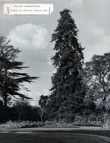
Photograph - Black and white print, Sequoia sempervirens
Note by T.H. Kneen 8 July 1992, "The reference to the planting of this tree in "Green Grows Our Garden" is not correct. Correspondence from Charles French held in the archives indicates that the Horticultural Society of Victoria met at Burnley in 1857 and Charles French then an apprentice in a nursery at Richmond was asked to plant the tree. The writer of G.G.O.G. did not see this correspondence and relied on my recollections which proved to be faulty."View of the Sequoia sempervirens and Jacaranda mimosafolia and the beds in front. Labelled, "Sequoia sempervirens planted by Charles French 1857."charles french, green grows our garden, horticultural society of victoria, nursery, sequoia sempervirens, jacaranda mimosafolia -
 Bendigo Military Museum
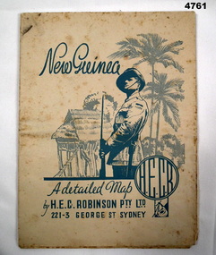
Map - MAP, NEW GUINEA, H.E.C Robinson PTY LTD, Post WW2
... Maps ...Map Robinsons “Territory of New Guinea and Papua” 0ff white colour rectangular shape, shows New Guinea, Papua, New Britain, New Ireland & Bougainville, colours red, orange, yellow, green designating boundaries, when folded one section has in blue a depiction of An Australian Soldier with palm trees & native hut.“Map No 315”maps, new guinea, robinsons -
 Beechworth Honey Archive
Map- Eldorado
Compiled from 1971 aerial photography. Printed in 1978.Map shows Eldorado town, Reedy Creek, abandoned gold dredge and Monument Hill. Scale 1:25,000. Printed colour on paper.Map labelled Eldorado. No. 8225-3-4map, eldorado, reedy creek, dredge, monument hill, aerial photography, paper, beechworth honey -
 Warrnambool and District Historical Society Inc.
Map, Department of Lands and Survey (Lithographers), Caramut township, 1938
This map of the township of Caramut was produced in 1938 but shows the original land owners of each town allotment and of the surrounding area. The size of all the allotments and the date of the original purchase are also shown. Caramut is a Victorian Western District town on Mustons Creek on the Hamilton Highway 48 kilometres from Warrnambool. This map was used by Rolf Crawley when he was the engineer for the Shire of Warrnambool from 1935 to 1968. The annotations on the map have probably been made by Rolf Crawley as they refer to the records and letter books of his father, John William Crawley, Junior (Shire of Warrnambool Engineer 1895 to 1935). Both Rolf Crawley and his father, John had private businesses as architects, surveyors and engineers and the map could have been used in connection with both their official Shire duties and their private businesses. The last owner of the map was the surveyor, Michael Hand who took over the business of Rolf Crawley in the late 1960s. This map is of great interest firstly because it has all the historical details of the land first purchased in the town of Caramut and area and secondly because it came from the office of Rolf Crawley, the engineer for the Shire of Warrnambool from 1935 to 1968. This is a buff-coloured paper map with a cloth backing. The map details are in black and white print. There are some handwritten red and black annotations on the map. “Town of Caramut Parish of Caramut County of Villiers’town of caramut, john william crawley junior, warrnambool, rolf crawley, warrnambool -
 Tatura Irrigation & Wartime Camps Museum
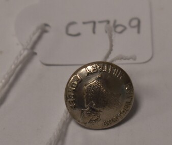
Button, Stokes and Son
Issued to Sister Kathleen Heaphy of Australian Army Nursing service. Sister Heaphy was attached, for part of her service, to 28 Camp Hospital Internment camp 1.round silver metal button with a metal shank. Crown and map of Australia and wording around the circumference. Australian Military Forces A crown and map of Australia Stokes and Sonsaustralian army nursing service, sister kathleen heaphy, 28 camp hospital internment camp 1, brass buttons -
 Bacchus Marsh & District Historical Society
Map, Village allotments, Parish of Myrniong, County of Bourke
Myrniong is a village 9 kilometers west of Bacchus Marsh. Prior to 1863 the area was known as Blow's Flat. This map which was produced in 1903 and according to the catalogue record of this map held at the State Library of Victoria was based on an earlier map created in 1861. The early layout of streets for the village of Myrniong can be seen on this map. The streets shown are, Main Street, Hardy Street, Blow Street, Myrniong Street, Shuter Street, and Blackwood Street. An area marked as a reserve for a school can be seen between Hardy Street and Main Street.A single page paper map. A cadastral parish map of Myrniong in Victoria, showing numbered land allotments. Photo-lithographed at the Department of Lands & Survey, Melbourne, in 1903. Based on an original map created in 1861. The map is pasted into a bound volume containing 76 maps or plans in total. High resolution digital image stored on BMDHS computer network. Surveyed by John Hardy, Surveyor ; photo-lithographed at the Department of Lands & Survey, Melbourne by T.F. McGauran, 24.12.03myrniong parish plan, myrniong parish maps -
Stawell Historical Society Inc
Map - Electoral Map, Victorian Government, Map of North - Western ( Country) Electoral Province Legislative Council 1934, 1939
Electoral MapMap Overprinted with Provinces In RedScale 8 Miles to 1 Inchgovernment -
 Bendigo Military Museum
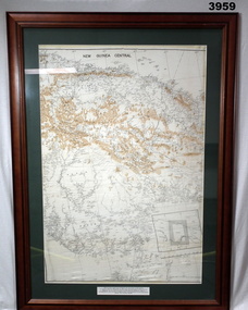
Map - MAP, NEW GUINEA FRAMED, C. 1941 onwards
Map of central section of New Guinea. Black print on white background with mountain ridges in tan. Map is mounted with green border. Brown wooden frame, glass front, white cardboard backing with wire hanging strap on back. Map prepared under the direction of RAAF Headquarters.Printed in black top centre: “NEW GUINEA CENTRAL” Printed on border under map: “These escape maps were carried in the zip pocket of life jackets by fighter pilots in WW2. This map was presented to A.S.R. on 12.7.79 by Councillor Ian McKenzie, Mayor of Eaglehawk, who served as a fighter pilot in 78th SDN in the SW Pacific area during 1943-44.”map, new guinea, central, raaf -
 Melbourne Legacy
Document - Document, letter, Ex-Legatee Louis Vavijinski, 1969
Various documents recording the discussions around helping an ex-Legatee who needed financial assistance. Louis Vavjinski was a member of Legacy in the early years (1920s and 1930s) and gave remarkable service especially to boys' classes where he was an excellent instructor. He had married a French lady at the end of World War 1 and they returned to France after the second world war. By the 1960s he was in financial difficulties and the correspondence points out that he was not eligible for an Australian pension due to living in France. A group of Legatees worked together to raise funds (over £1000) to send Louis, in one letter they approached Legacy President Ivan Layton for funds from the Presidents fund. This shows that legatees form strong bonds with each other and have a desire to help anyone in need. The Presidents Fund was created in 1932 with the aim to give the President a way to help needy cases with discretion and without having to gain approval from committees. In many cases the money was repaid by the recipient. This document was in a folder labelled President's Fund Correspondence and was with other file items about donations to help appropriate cases. The folder was marked with H40 which is part of an early archive project from the late 1960s and early 1970s.The Presidents Fund was a significant help to legatees and junior legatees who were unable to obtain help from other sources.File copy of correspondence about sending money to Louis Vavijinski in France in 1969.financial help, presidents fund -
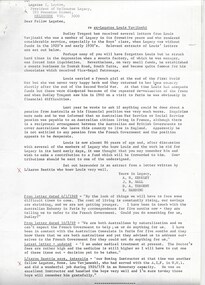
 Bendigo Military Museum
Postcard - POSTCARDS WW1, PHOTOGRAPHIC, C.1914 - 18
Photos of soldiers and Bombardment scenes from battlefields in Flanders in WW1.1. Picture of a street in France after a bombardment during WW1. B & W photo. 2. B & W photo of ambulances picking up wounded soldiers in a desolute bombed out village in France in WW1. 3. Soldiers standing in front of a bombed building in Poperinghe, Flanders, Belgium in WW1. 4. B & W studio photo of 5 British Soldiers from WW1 in uniform.1. In French and English says "Rue De Framboisiers after the Bombardment". 2. Says "R.A.M.C. picking up wounded in a captured village.passchendaele barracks trust, postcards, ww1 -
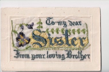
Beechworth RSL Sub-Branch
Silk Postcard Collection 1914-1919, Tom Eastwell collection - postcard No:1, Pre 1914
The popularity of woven sild postcards peaked during the First Workd War 1914-1918. A thriving cottage industry began around 1915 and the quaity and colours of the silks used is extremely high. This card is one of three cards presented by the Tom Eastwell family in 2018. Further infirmation on Australian War memorial website: www.awmgov/collection/accessing-records-at-the-memorial/findingaids/guide-silk-postcard-collection#S11Historic and social significance: the ability of the sender to reassure their family of their wellbeing through the sending of embroidered postcards was a common practice among deployed servicemen during the First World War.Small light embossed cardboard and woven silk with embroidery on the front. The rear for correspondance, name and postal detailsWoven silk cards were first made in 1900 for the Paris Exhibution and became popular during WWI 1914-1918 . Embroidery depicting flags of France, Great Britain, Germany, Belgium and Italy, laurel leaf wreath, a thistle, red rose and the Red Cross Insignia. A check on the colours and design of all flags should be conducted. Message on rear: “With Best Love To Little Maisie from Tom xxxxxxxxxxxx “. post card; carte postale; postkaart; embroidered postcard -
Clunes Museum
Map - MAP OF CLUNES, FENTON CHARLES
THESE MAPS WERE SOLD IN CLUNES MUSEUM PRIOR TO TH REDEVELOPMENTOF THE WAREHOUSE BY HEPBURN SHIRE COUNCIL. MAPS WERE SOLD FOR $ 1.504 COPIES OF MAP OF CLUNES 1987map, clunes 1987, charles fenton, map of clunes -
 Bendigo Military Museum
Album - ALBUM, PHOTOGRAPH, WWI
The album was owned by Jack Grinton 1043, 38th Batt AIF. Part of the Grinton collection which included hundreds of negatives and developed photos that he took in England and France during WW1. He reproduced many himself in his hut in England prior to going to France. Refer Cat No 1280 for service details. Refer 1317P, 1320P. Dark blue photo album with string and tassels. Six pages, grey background with 22 B&W photos of England and France.Hand written remarks in ink under each photo.books- albums, photography - photographs -
Clunes Museum
Pamphlet - TOUR AND MAP, RICHARD AITKEN, TALBOT WALKING TOUR, 1988
PUBLISHED FOR BICENTENNIAL COMMEMORATION 1988TALBOT WALKING TOUR AND MAP. PUBLISHED BY TALBOT AND CLUNES HERITAGE PROJECT. WRITTEN BY RICHARD AITKEN, 1988PHOTO OF TALBOT TOWN HALL; HISTORY; DESCRIPTIONS OF BUILDINGS AND MAPtalbot, tour, map, 1988, aitken -
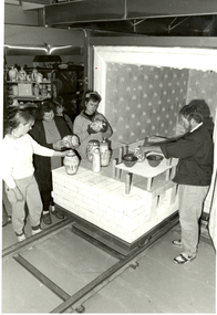 Federation University Historical Collection
Photograph - Photograph - black and white, Neville French and Ceramics Students Loading a Kiln, c1990
Neville French taught ceramics on the SMB campus for many years.Neville French (right hand side) and 4 students inspect ceramics work around a kiln at the Ballarat School of Mines Technical Art School.ballarat school of mines, ballarat technical art school, art, ceramics, pottery, neville french, kiln -
 Lara RSL Sub Branch
Memento, Sweetheart Cards WW1, World War 1
Sweetheart cards WW1 Woven silk postcards were produced in Krefeld in 1898 , Germany. Embroidered silk postcard were first made in Paris in 1900. The popularity of the silk postcard peaked during World War 1. The different examples shown reflect what, and to whom the soldiers sent them to during this period. An estimated 10 million hand made cards were produced from 1915 1919. Tjhe cards were generally hand embroidered by French women in their homes on strips of silk mesh, with as many as 25 on strip. They were then sent to a factory for cutting and mounting on postcards. Rectangular post cards , cream coloured with silk embroided silk motifs on the frontpostcards, sweetheart cards, silk embroidered cards, world war 1, lara rsl, france -
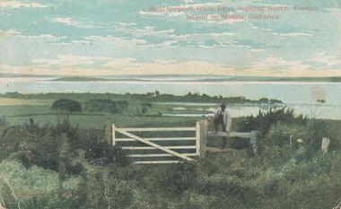 Phillip Island and District Historical Society Inc.
Photograph - Post Card, Early 1900's
One of a collection of photographs donated by Shirley Peterson.Colour postcard of farmland in foreground looking across Westernport from Rhyll. French Island in the distance. Man standing on fence beside gate."Westernport from Rhyll, looking North, French Island in Middle Distance." "Robb Bros. Cowes" On back a letter from M Evans of Ventnor to ?? in Ascot Vale.rhyll farmland phillip island, westernport bay, phillip island, shirley peterson -
 Peterborough History Group
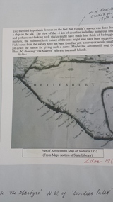
Document - Peterborough survey, Heytesbury District
About Peterborough town and the surrounding Council districts, coastal survey and mapshistory of the development of the townMaps, photocopiesflaxman hill, peterborough history, heytesbury, peterborough 3270 -
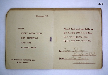 Bendigo Military Museum
Card - XMAS CARD, 1917
The card made by the 3rd Australian Tunnelling Coy AIF France.Christmas card with gold stamped rising sun badge. On Active Service with printed insetHandwritten on insert"Rose Lehmer/New South Wales/Brother Harry/Francedocuments-cards, christmas, aif -
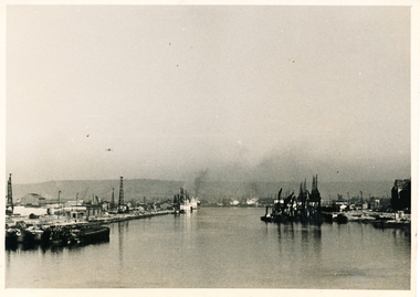 Mission to Seafarers Victoria
Photograph - Gelatin silver photograph, Allan Charles Quinn, Port of Rouen, 05 June 1949
This photograph is one of a series taken by Allan Quinn while travelling through France in mid-1946. There are several letters relating to this journey.This is a photograph from the Allan Charles Quinn collection which is a collection of letters and photograph depicting aspects of life at sea for a young man in the era immediately following World War II.A black and white photograph of the port at Rouen, France, taken on the 5th of June, 1949. There is a narrow white boarder around the image.On reverse: PORT OF ROUEN / 5-6-49 handwritten in blue ink. Below this is the mark "ItI"in pencil.allan-quinn, photograph, port-of-rouen, france -
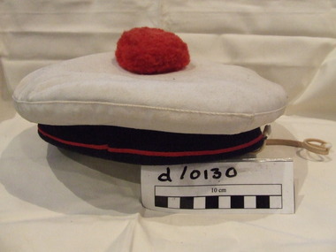 Waverley RSL Sub Branch
Cap French Naval
Worn by french navy during WWIICloth French naval cap with white crown blue band with red stripe and red "pompom" in centre of top. Cap has an attached webbing chin strap.cap french navy -
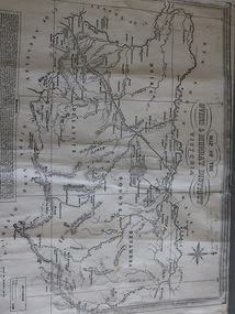 Kiewa Valley Historical Society
Map of the Ovens and Murray District of Victoria
The map features Beechworth and its history.This map features the north-east and in particular, Beechworth where residents of the Kiewa Valley may have shopped or visited for appointments.Black and white map with references to roads and gold. The centre of the map is Beechworth and in the bottom left side of the map is the heading Beechworth with 12 lines of print of information regarding Beechworth. The Kiewa Valley is not identified.beechworth -
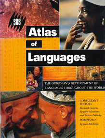 Victorian Aboriginal Corporation for Languages
Book, Bernard Comrie, SBS SBS atlas of languages : the origin and development of languages throughout the world, 2003
... maps ...Over 30 full-colour maps, over 40 of the world?s major languages, language family trees, over 100 stunning full-colour photographs. A full glossary of linguistic terms.Maps, colour illustrations, colour photographslinguistics, maps, atlases -
 Bacchus Marsh & District Historical Society
Map, Coimadai Parish Map, County of Bourke. Circa 1890s-1900s
The cadastral Parish of Coimadai, a subdivision of the County of Bourke, lies directly north of the township of Bacchus Marsh. The date of this map is uncertain. T.F. McGauran the person who made a photo-lithographic copy of the map was in charge of photo-lithography at the Victorian Department of Lands and Survey in the late 19th century until about 1910.A single page paper map showing the map for the Parish of Coimadai in the County of Bourke. A cadastral map showing parish boundaries and land ownership. A rectangle shaped area is missing from the centre of the map due to a tear or deliberate excision. The map is pasted into a bound volume containing 76 maps or plans in total. High resolution digital image stored on BMDHS computer network. Photo-lithographed at the Department of Lands and Survey, Melbourne by T.F. McGauran 26.8.[??] NOTE. Photo litho from L.P showing temporary surveys and occupation of land prepared for departmental use onlybacchus marsh region parish plans, coimadai parish maps, coimadai parish plan -
 Mission to Seafarers Victoria
Photograph, Allan Charles Quinn, Mostly from the time of Joan of Arch - Rouen, 05 June 1949
This photograph is one of a series taken by Allan while travelling through France in mid-1946. There are several letters relating to this journey.This is a photograph from the Allan Charles Quinn collection which is a collection of letters and photograph depicting aspects of life at sea for a young man in the era immediately following World War II.A black and white photograph of a narrow laneway in Rouen, France, taken on the 5th of June, 1949. There is a narrow white boarder around the image.On reverse: ROUEN 5-6-49 handwritten in blue ink. Below this is a mark "ItI"in pencil, written sideways.allan-quinn, photograph, rouen, france -
 Creswick Campus Historical Collection - University of Melbourne
Map, Creswick, 1943
Dept of Lands and Survey map of Creswick and county of Talbot. 2 linen backed sheets rolled into white cardboard cylinderMaps -
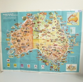 Greensborough Historical Society
Map, International Harvester, Australia. Land of tomorrow, 1965_
This 1960s map of Australia shows areas of economic development at that time.Colour map of Australiaaustralia economic development, international harvester -
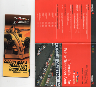 Melbourne Tram Museum
Booklet, Metlink, "Information for public transport staff - 2006 Formula 1 Australian Grand Prix", 2006
Gives details of event for train, tram and bus crews, event program and transport map, including shunting details, announcements, bus replacement services, electric or automatic points, route alterations. On the back cover has contact telephone numbers and web addresses - Published by Metlink. Fold out map gives a detail map of the course, locations for transport and details of the event - published by the Grand Prix corporation. Yields information the 2006 Grand Prix event at Albert Park.Set of 2 items - both within a clear plastic envelope. 1 - booklet 40 pages with foldout map centre stapled 2 - 16 fold map - circuit map and transport guide tramways, grand prix, metlink, formula 1, albert park -
Federation University Historical Collection
Plan (copy), Frederick Proeschel, Map of the Roads to all the Gold Mines in Victoria, 1853
The map was pirated from Frederick Proeschel's "Pocket Map of the Roads to all the Gold Mines in Victoria" issued earlier in 1853.Digital file of the Map of the Roads to all the Gold Mines in Victoria. The map has been coloured to show routes to the Victorian goldfields from Melbourne and Geelong.frederick proeschel, proeschel, gold, mining, philp -
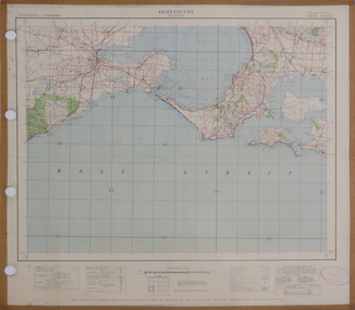 Federation University Historical Collection
Map, Queenscliff, 1942, 1942
Two copies of printed colour map on paper showing Queenscliff and surrounds"This map in an official document, if found, it must be handed in to the nearest military headquarters or police station."queenscliff, portsea, point nepean, point lonsdale, barwon heads, geelong, corio bay, port phillip bay