Showing 756 items
matching line drawings
-
 Federation University Art Collection
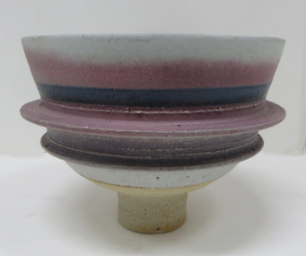
Ceramic - Artwork - Ceramics, Stoneware Bowl by Robin Welch, 1980
Robin WELCH ( 23 July 1936-5 December 2019) Born Nuneaton, Warwickshire, England Robin Welch is one of the most highly respected contemporary British potters. The full range of his work includes large vessels with related paintings, fine drawings, and distinctive bowls and vases which explore colour, surface texture, form, detail of edge, and line. He is one of small group of significant British potters who expanded the language of throwing pots on the wheel through post-wheel additions and alteration. This gave his generally cylindrical forms a more organic and sculptural aspect, but their heavily coloured and textured surfaces were as much about painting, too, as Robin sought an integration of the visual disciplines he enjoyed. As he once wrote: “There’s no divide between art or craft. You decide to be an artist and you’ll use anything. If marooned on a desert island you’d use driftwood.” (https://www.theguardian.com/artanddesign/2019/dec/27/robin-welch-obituary, accessed 23 March 2021) Initially studying at Penzance School of Art under Michael Leach (son of Bernard Leach) and the Central School of Art, London Robin Welch then worked part-time at the Leach Pottery between 1953 and 1959 before opening his own pottery in London's west end (1960 to 1962). After a couple of years of world travel, including working in Australia from 1962 to1965 helping Ian Sprague set up his Mungeribar Pottery and exhibiting in Melbourne, Robin Welch returned to England setting up Stadbroke Pottery in Eye, Suffolk in 1965. Apart from his studion work Robnin Welch was a skilled designer for industry including Wedgwood. When not in his Suffolk studio Robin Welch spent much time in Australia where he appreciated the outback’s arid earth, brilliant light, grittier textures and luminous colour. Stoneware bowl on a tall foot. Calcium matt glaze, underglaze colour with underglaze metallic lustre. ceramic, jan feder memorial ceramics collection, robin welch, gippsland campus, mungeribar pottery, stadbroke pottery -
 Federation University Art Collection
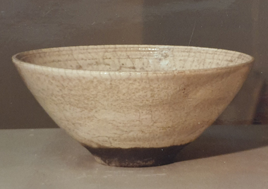
Ceramic, Raku Fired Bowl with White Crackle Glaze by Robin Welch, 1980
Robin WELCH (1936- ) Born Nuneaton, Warwickshire, England Robin Welch is one of the most highly respected contemporary British potters. The full range of his work includes large vessels with related paintings, fine drawings, and distinctive bowls and vases which explore colour, surface texture, form, detail of edge, and line. Initially studying at Penzance School of Art and the Central School of Art, London Robin Welch then worked part-time at the Leach Pottery between 1953 and 1959 before opening his own pottery in London's west end (1960 to 1962). After a couple of years of world travel, including working in Australia from 1962 to1965 helping Ian Sprague set up his Mungeribar Pottery and exhibiting in Melbourne, Robin Welch returned to England setting up Stadbroke Pottery in Eye, Suffolk in 1965. This work is part of the Jan Feder Memorial Ceramics Collection. Jan Feder was an alumna of the Gippsland Campus who studied ceramics on the campus. She passed away in the mid 1980s. Her student peers raised funds to buy ceramic works in her memory. They bought works from visiting lecturers who became leading ceramic artists around the world, as well as from many of the staff who taught there.Raku Fired stoneware bowl with White Crackle Glaze by Robin Welch Robin Welch stamped on baserobin welch, ceramics, jan feder memorial ceramics collection, gippsland campus -
 Federation University Art Collection
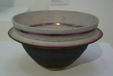
Ceramic, Bowl by Robin Welch, 1980
Robin WELCH ( 23 July 1936-5 December 2019) Born Nuneaton, Warwickshire, England Robin Welch is one of the most highly respected contemporary British potters. The full range of his work includes large vessels with related paintings, fine drawings, and distinctive bowls and vases which explore colour, surface texture, form, detail of edge, and line. He is one of small group of significant British potters who expanded the language of throwing pots on the wheel through post-wheel additions and alteration. This gave his generally cylindrical forms a more organic and sculptural aspect, but their heavily coloured and textured surfaces were as much about painting, too, as Robin sought an integration of the visual disciplines he enjoyed. As he once wrote: “There’s no divide between art or craft. You decide to be an artist and you’ll use anything. If marooned on a desert island you’d use driftwood.” (https://www.theguardian.com/artanddesign/2019/dec/27/robin-welch-obituary, accessed 23 March 2021) When not in his Suffolk studio Robin Welch spent much time in Australia where he appreciated the outback’s arid earth and brilliant light, its grittier textures and luminous colour, qualities he sought to convey in-the-round and on canvas. Apart from his studion work Robnin Welch was a skilled designer for industry including Wedgwood, Midwinter and Denby. Initially studying at Penzance School of Art under Michael Leach (son of Bernard Leach) and the Central School of Art, London Robin Welch then worked part-time at the Leach Pottery between 1953 and 1959 before opening his own pottery in London's west end (1960 to 1962). After a couple of years of world travel, including working in Australia from 1962 to1965 helping Ian Sprague set up his Mungeribar Pottery and exhibiting in Melbourne, Robin Welch returned to England setting up Stadbroke Pottery in Eye, Suffolk in 1965.Stoneware bowl with split flange, glazed with matt white, black and a touch of copper red Tobin Welch stamped on basejan feder memorial ceramics collection, ceramics, robin welch, gippsland campus, jan feder -
![Drawing - Pencil on Paper, [Group of sketches] by Sybil Craig, 1935](/media/collectors/530576742162ef0fa09a2288/items/534748169821f420f8c0373d/item-media/5eff422b21ea6712bcf90559/item-fit-380x285.jpg) Federation University Art Collection
Federation University Art CollectionDrawing - Pencil on Paper, [Group of sketches] by Sybil Craig, 1935
Sybil CRAIG (18/11/1901-09/09/1989) Born London, England Arrived Melbourne 1902 Died Melbourne, Victoria Sybil Frances Craig was a student of John Shirlow in 1920 who introduced her to French avant-garde artists such as Matisse and Gauguin. In 1924 she studied at the National Gallery of Victoria Art School. She also underook private classes with George Bellfor several months where individual expression was encouraged, and she became associated with a group of Modernist artists including Sam Atyeo. In 1945 Sybil Craig became the third woman to be appointed as an official war artist. Based in Melbourne she worked for fourth months at the Commonwealth Ordinance Factory at Maribyrnong, becoming the first female artist to paint women working in the munitions factories. In her work Craig was attracted to many changing ideas and continued to explore line, rhythm, colour, simplicity and design. This item is part of the Federation University Art Collection. The Art Collection features over 2000 works and was listed as a 'Ballarat Treasure' in 2007.Framed pencil sketch.art, artwork, sybil craig, australian war artist, kitchen -
![Drawing - Texta on paper, [Flower Study] by Sybil Craig, 2001](/media/collectors/530576742162ef0fa09a2288/items/534748169821f420f8c0373e/item-media/58cf4cb1d0ce1e3314911c72/item-fit-380x285.jpg) Federation University Art Collection
Federation University Art CollectionDrawing - Texta on paper, [Flower Study] by Sybil Craig, 2001
Sybil CRAIG (18/11/1901-09/09/1989) Born London, England Arrived Melbourne 1902 Died Melbourne, Victoria Sybil Frances Craig was a student of John Shirlow in 1920 who introduced her to French avant-garde artists such as Matisse and Gauguin. In 1924 she studied at the National Gallery of Victoria Art School. She also underook private classes with George Bellfor several months where individual expression was encouraged, and she became associated with a group of Modernist artists including Sam Atyeo. In 1945 Sybil Craig became the third woman to be appointed as an official war artist. Based in Melbourne she worked for fourth months at the Commonwealth Ordinance Factory at Maribyrnong, becoming the first female artist to paint women working in the munitions factories. In her work Craig was attracted to many changing ideas and continued to explore line, rhythm, colour, simplicity and design. This item is part of the Federation University Art Collection. The Art Collection features over 1000 works and was listed as a 'Ballarat Treasure' in 2007.Framed texta sketch of a correa.art, artwork, sybil craig, craig, flora, available, leaves, texta, texta colour, correa -
 Federation University Art Collection
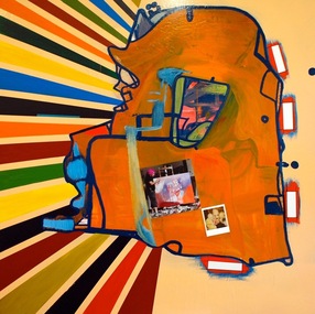
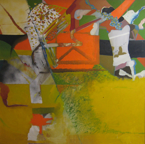
Painting - Artwork, 'Looking for God in Abstract Art 2' by Gareth Sansom, 2010
Gareth SAMSOM (19 November 1939- ) Born Melbourne Sansom describes a desire to constantly surprise and challenge himself as an artist. He had his first exhibition in 1959. His paintings of the 1960s were characterised by a distorted use of line, shape and colour and were influenced by abstract expressionism, Francis Bacon and Sidney Nolan. Over time, his work has also drawn on punk, dada, Basquiat, T.S. Eliot, urban graffiti, classical Greek philosophy and art theory across a variety of media ranging from drawing, printmaking and collage to photomontage and photography. Sansom lectured in Art at the Ballarat Teachers' college, and was appointed Head of Painting at the Victorian College of the Arts from 1977-1985, and Dean School of Art at the Victorian College of the Arts from 1986-1991. He was artist-in-residence at the University of Melbourne in 1985, which was when he resumed his full-time painting practice with a series of large works on canvas. The Federation University Art Collection features over 1000 works and was listed as a 'Ballarat Treasure' in 2007.'Looking for God in Abstract Art 2' is a play on the debate over the respective virtues of abstraction and figuration that has preoccupied artists and critics for more than a century. Sanson has always walked a wobbly line between the two, adroitly avoiding falling headlong into either camp. It is also a gentle dig at the pretensions to higher spiritual meaning in abstract art. In the centre are two photographs, one of rubber masks and the other of the artist in a lurid fright wig and mask and using a spray can like a young tagger. These images, where the artist wears a mask and teeters on bright red platforms, are wonderfully ludicrous send-ups of the 'fine art' of painting. (Geoff Wallis from 'Gareth Sansom: Alternative Person", Art Gallery of Ballarat, 2012) This work was exhibited and published in the catalogue of the exhibition 'Gareth Sansom: Alternative Person' at the Art Gallery of Ballarat in 2012 item. art, artwork, gareth sansom, sansom, mixed media, oils, enamel, photo-collage -
 Federation University Art Collection
Painting, Gareth Sansom, 'Metropolis' by Gareth Sansom, c1975
Gareth SAMSOM (19 November 1939- ) Born Melbourne Sansom describes a desire to constantly surprise and challenge himself as an artist. He had his first exhibition in 1959. His paintings of the 1960s were characterised by a distorted use of line, shape and colour and were influenced by abstract expressionism, Francis Bacon and Sidney Nolan. Over time, his work has also drawn on punk, dada, Basquiat, T.S. Eliot, urban graffiti, classical Greek philosophy and art theory across a variety of media ranging from drawing, printmaking and collage to photomontage and photography. Sansom lectured in Art at the Ballarat Teachers' college, and was appointed Head of Painting at the Victorian College of the Arts from 1977-1985, and Dean School of Art at the Victorian College of the Arts from 1986-1991. He was artist-in-residence at the University of Melbourne in 1985, which was when he resumed his full-time painting practice with a series of large works on canvas. This item is part of the Federation University Art Collection. The Art Collection features over 1000 works and was listed as a 'Ballarat Treasure' in 2007.A large abstract painting.art, artwork, garth sansom, sansom, abstract -
 National Communication Museum
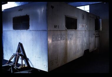
Vehicle - Mobile Telephone Exchange, c. 1965
Manufactured in the 1960s, this mobile emergency telephone exchange was fitted into a caravan. Part of the Shepparton Division State Disaster Plan, the caravan could be towed to areas affected by disasters to enable communications to recommence. The caravan remained in service until approximately 1974.Mobile infrastructure plays an important role in Australian communications, owing to the often remote and hostile environments in which Australians live and work. Exchanges such as this facilitated phone calls in the aftermath of an emergency, particularly for hospitals, police and other emergency services. Today, Mobile Exchange on Wheels (MEOWs), Cell on Wheels (CoW) and Satellite Cell on Wheels (SatCOW) - which provide temporary landline and broadband services, mobile phone coverage and service in areas without communications infrastructure respectively - are a critical part of emergency response procedures for natural disasters such as fire and flood. Though technology has progressed, the need for rapid service in remote areas remains a present concern of the communications service providers in Australia. This mobile service infrastructure is historically significant as an early example of a service which has evolved over decades, yet is still needed today. The exchange, as a representative example of a vehicle which would provide early-response in a disaster, is socially significant as a facilitator of critical communications needs in devastated communities: access to emergency services and contact with family and friends. The exchange itself, intact from its period of use, provides an insight into technology of the 1970s.Mobile emergency exchange housed in a caravan trailer on 2 wheel base, duralin body, steel tow bar, Caravan divided into 3 sections; the exchange room; the relay room and the main frame room. The exchange room contains 3 switchboards, a folding table, cupboards, benches and switch rack (.1). table (.2), steel bar for attaching the table (.3), back boards of switchboards (.4-.6), switches (.7-.16), box of switches (.17). There is a wall phone magneto, 300 type handset on wall and 2 skylights with wire screens. .11? hat pegs and shelf; there are 2 fluorescent tubes for lighting, all in exchange section. The floor is covered with 2 tone grey tiles and there are wire mesh on outside of windows and a geometric curtain inside behind switch rack. There is a flywire screen door as well as exterior door. The relay room has a sectioned door so half can open at a time. Room contains a cupboard with folding bench top beneath a curtained window. The opposite wall has a bank of batteries and transmission condensers; there is a shelf above window, one fluorescent tube and fuse boxes. Tiles on floor also. The main frame room contains many metres of coiled black covered cable, a black covered magneto wall telephone with 300 type handset; grey plastic jumper cords, a rack of termination points and wire with wasp nests attached. There is a small iron step under door, a fluorescent tube on wall and 3 hat hooks. Roll of Paper Handtowels (.18), cord and handle (.19), red exchange cords and plugs (.20-.22), plastic aluminium runners (.23,.24), headset (.25,.26), logbook (.27), battery readings (.28), box containing papers circuit drawings etc (.29-.93), paper lists off wall (.94,.95). Books, record books etc (.96-.103). Manila folder (.104) containing circuit drawings (105-.124). Wooden drawer (.125), metal drawer containing subscribers master cards, record of faults cards, particular switchboards connected, Junction line cards (.126). Box of valves (.127), box of clamps (.128). Box of 2000 type rack fuses, red 1 1/2 AMPS, black 3 AMP, blue 1/2 AMP (.129). Box of sleeves for covering wire joints (.130), plastic beakers (.131,.132), soap (.133), box of white plastic squares (.134), time switch "Venner BF/43 time switch" Made in England (.135), box of bolts, knobs etc (.136), box of switchboard number indicators (.137), fuse (.138), fuse wire (.139), football card (.140). Box of cartridge fuse 6 AMP (.141). Envelope of drawing pins, rubber bands (.142), black plastic, paper tape centres (.143-.152), metal plug (.153), 2 signs "Beware of vehicles" (.154-.155). Paper listing Naringal East automatic conversion (.156). Green Commonwealth of Australia note pad (.157). Wiring plug for tail lights (.158). Black fuse plugs (.159,.160). Box of bolts (.161). 2 sections of blue plastic coated wires (.162,.163). Gloves used for working on batteries (.164-.167). Wasp nests (.168,.169). White fuse (.170). Photographs of van in use (.171,.172)..1 on front: "ANOTHER / MOBILETRAIL / PRODUCT" "MAX SPEED / 25MPH" "TRAILER BRAKES / --- / " On sides: "EMERGENCY TELEPHONE EXCHANGE" "NO 1" "PMG" "TCQ / GROSS 250 / TARE 182 / LOAD 162" "6" "COUNTRY BRANCH / NORTH REGION / [SHEPPARTON DIVISION]" "LAW'S SIGNS" "Telecom Australia" On back: "DANGER / LONG LOAD" "MQA 3787" .133: "FIR OIL" "AUSTRALIA"mobile telephone exchanges, mobile telecommunications trailers, trailers, transport, natural disaster, black saturday, bushfires, floods, emergency communications -
 Federation University Art Collection
Drawing, Victor Cobb, At Miss Bale's Castlemaine by Victor Cobb, 26/4/1931
Victor Ernest COBB OM (14 August 1876-2 December, 1945) Born Footscray, Victoria Victor Cobb studied drawing under Bernard Hall at the National Gallery School in 1896. He was self taught in the art of etching, creating his own press and tools. He became known for his popular views of Melbourne and as a teacher of etching. Melbourne Grammar School marked its sesquicentenary in 2008. As part of the celebrations, a Talents Committed Exhibition was staged. This exhibition recognised 150 Old Melburnians who have made a difference to the City of Melbourne, the State of Victoria and the wider community in Australia and overseas. The above profile was included in the Talents Committed Exhibition in 2008. Double sided sketch by Victor Cobb. One side is 'At Miss Bale's, Castlemaine, the other is some line work towards a landscape26/4/31 At miss Bale's Castlemaine V.E.C.victor cobb, castlemaine, a.m.e. bale, landscape -
Federation University Art Collection
Drawing, Victor Cobb, At Castlemaine by Victor Cobb, 26/4/1931
Victor Ernest COBB OM (14 August 1876-2 December, 1945) Born Footscray, Victoria Victor Cobb studied drawing under Bernard Hall at the National Gallery School in 1896. He was self taught in the art of etching, creating his own press and tools. He became known for his popular views of Melbourne and as a teacher of etching. Melbourne Grammar School marked its sesquicentenary in 2008. As part of the celebrations, a Talents Committed Exhibition was staged. This exhibition recognised 150 Old Melburnians who have made a difference to the City of Melbourne, the State of Victoria and the wider community in Australia and overseas. The above profile was included in the Talents Committed Exhibition in 2008. Double sided sketch by Victor Cobb. One side is 'At Castlemaine, the other is some line work towards a landscape V.E.C. At Castlemaine 26/4/31victor cobb, castlemaine, a.m.e. bale, landscape -
 Mont De Lancey
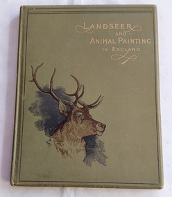
Book, Vere Foster's Watercolour Series, Landseer and Animal Painting in England, c1890's
A useful book for artists wishing to learn the techniques of drawing and painting animals by Edwin Landseer and other notable English artists in the early 1890's. The reproduced coloured plates and engravings support the text and advice.An antique green hardcover Edwin Landseer and Animal Painting in England book - Vere Foster Series with the title printed in gold lettering at the top right hand corner with a large head of a stag with black and brown lines in the bottom left hand corner.There is a thin black line surrounding the edge of front cover. The spine and back cover are plain green. There is gilt on the edges of the pages. Inside are guidelines for drawing and painting animals as suggested by Landseer and other well known English artists of the time with several reproductions of coloured plates as well as black and white engravings. Stephen T. Dadd gives practical hints. At the back are lists of Vere Foster's water-colour books and Blackie Publications.Pp 84.non-fictionA useful book for artists wishing to learn the techniques of drawing and painting animals by Edwin Landseer and other notable English artists in the early 1890's. The reproduced coloured plates and engravings support the text and advice.painting, art, art books, artists, artworks, etchings -
 Mont De Lancey
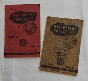
Booklet - Knitting Patterns, The Country Womens Associaotion of Victoria, War Workers' Woolcraft, c.1940's
The red covered book is compiled by The Country Women's Association of Victoria and sponsored by the Australian Wool Board. On the back of the front cover is an Introduction by the Chairman of the Australian Wool Board, Sir Dalziel Kelly, K.B., L.L.B. explaining the reason for these books encouraging the use of Australian wool to support the Empire Forces. The Foreward promotes the CWA in a similar vein. The book has knitting hints, patterns useful for war service members in the navy, army and air force patterns for clothing.The khaki covered book is similar, but is compiled by the Country Women's Association of Victoria. It is a Third Edition.Two small copies of War Workers' Woolcraft - Knitting and Spinning books: one with a red paper cover and the other with a faded khaki coloured paper cover. 1. The red front cover book shows the title printed inside a black cloud shape with a black lined illustration of a ball of wool underneath. The Country Women's Assoc. South Aust. is printed on the cover inside a round shaped black crest. It is compiled by The Country Women's Association of Victoria and sponsored by the Australian Wool Board. Inside on the back of the front cover is an Introduction by the Chairman of the Australian Wool Board, Sir Dalziel Kelly, K.B., L.L.B. explaining the reason for these books encouraging the use of Australian wool to support the Empire Forces. The Foreward promotes the CWA in a similar vein. The book has knitting hints, patterns useful for war service members in the navy, army and air force patterns for clothing - caps, sleeveless pullover, waistcoat muffler, armlets, man's socks and mittens, kneecaps, hot water bottle covers and scarves. Inside the back cover is advice on checking your tape measure against the 6 Inch one printed on the page. 2. The khaki covered book is similar, but is compiled by the Country Women's Association of Victoria with Price 3d.- posted 4d. at the bottom of the cover. It is a Third Edition. Both have advertising on the last few pages.non-fictionThe red covered book is compiled by The Country Women's Association of Victoria and sponsored by the Australian Wool Board. On the back of the front cover is an Introduction by the Chairman of the Australian Wool Board, Sir Dalziel Kelly, K.B., L.L.B. explaining the reason for these books encouraging the use of Australian wool to support the Empire Forces. The Foreward promotes the CWA in a similar vein. The book has knitting hints, patterns useful for war service members in the navy, army and air force patterns for clothing.The khaki covered book is similar, but is compiled by the Country Women's Association of Victoria. It is a Third Edition. knitting, knitting patterns, knitting equipment -
 Mont De Lancey
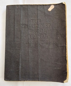
Book, Wesleyan Methodist Sunday School Department, The Methodist School Hymnal, Early 1900's
A Methodist School Hymnal book for use in schools in Australasia for the moral training of children. A thin black paperback vinyl covered vintage copy of The Methodist School Hymnal. The title is stamped into the front cover with a rectangular lined shape around it. There is a Preface, able of Contents, Index of First Lines, Appendix and Australasian Supplement. Pp 256.On the back left end paper is a child's pencil drawing of a face.religious books, hymn books, hymns, hymnals -
 Mont De Lancey
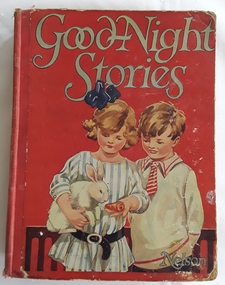
Book, Thomas Nelson and Sons, Ltd, Goodnight Stories - Happy Stories and Jolly Pictures for the little Folks, c1900's
A collection of illustrated stories, nursery rhymes and poems for very young children by assorted authors. It has large print, wear on the front cover, some stains on the back cover, foxing on the edges of the pages.A large red hardcover book with the title Goodnight Stories printed in blue lettering at the top with the publisher, Nelson at the right hand bottom corner. There is a coloured illustration of a young girl holding and feeding a white rabbit with a boy looking on. The spine has the title, a black outline drawing of a girl and the publisher at the bottom. Poems, rhymes and stories are illustrated with black lined illustrations and some coloured plates. 160p.fictionA collection of illustrated stories, nursery rhymes and poems for very young children by assorted authors. It has large print, wear on the front cover, some stains on the back cover, foxing on the edges of the pages. children's fiction., nursery rhymes -
 Mont De Lancey
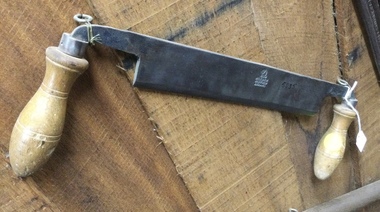
Tool - Draw Knife, Hale Bros
A flat straight metal woodworking tool with two wooden line patterned handles used to remove surplus large chunks of wood and taper the sides of timber for floorboards, paneling and such before planing them. It can be used to to fashion tool handles, wooden sculptures stool legs or wheel spokes. The final finishing on such work was done by a Spoke Shave tool which we also have in our collection.Stamped on the blade is a horse head with the manufacturer's name Hale Bros Sheffield England below.woodcarving tools, drawing knives, shaves, handtools, iron -
 Melbourne Legacy
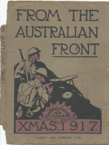
Book, From the Australian Front. Xmas 1917, 1917
A book of drawings and photos published about the trenches in Europe in 1917. Put together by the Australian Commonwealth Military Forces and published by a British publisher. Reproductions of official photographs and cartoons and sketches by members of the A.I.F. Photos show life in the trenches and the war zones, including Ypres, Hill 60, Hindenburg line, Bapaume, Menin Road, Zonnebeke and more. Plus conducting battle operations, Boche prisoners, ruined towns and churches, and the wounded awaiting transport. Most of the drawings are humorous. It is incomplete, the back cover is missing and the pages are only from Page 1 to 24 and 57 to 127. Information from the Australian War Memorial archives says it should have been 157 pages long. Was with other World War 1 memorabilia that has come from Private John Basil McLean, 2nd Reinforcements, 37th Battalion, A.I.F. J.B. McLean (Service No. 13824) was from near Maffra, Victoria and enlisted on 22 January 1916. He embarked on 16 December 1916 for Europe. His full war record is available from AWM. He spent time with the Australian Field Artillery (Pack Section). At the end of the war he worked for a year at the A.I.F. Headquarters in London before returning to Australia on the 'Ceramic', arriving Portsea in 1920.A record that photos from the trenches were published as a memento of Christmas in 1917, presumably for the troops.A book of black and white photos and drawings published for the troops in World War 1.Title page has 'JB McLean / Maffra' handwritten in blue ink.world war one, souvenir -
 Melbourne Legacy
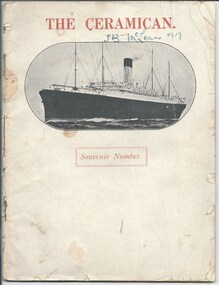
Magazine, The Ceramican. Souvenir Number, 1920
A commemorative publication from the voyage back to Australia aboard the ship The Ceramic in 1920. It departed Tillbury, UK 12th March and docked in Freemantle on 27th April 1920 and then went onto Adelaide, Melbourne and Sydney. The Ceramic was a transport vessel built in Belfast in 1913 for the White Star Line to transport frozen produce and apples from Australia to UK. It was taken over by the Australian Government for troop transport in October 1914 and could carry over 3,000 troops. This trip in 1920 there were 1467 on board, there were women and children as well as 439 soldiers returning home. The publication has articles of life on the voyage as well as poems, stories, photos and drawings compiled on-board. Notable events such as crossing the equator, a baby competition and stopping in Bombay were some of the photos. Was with other World War 1 memorabilia that has come from Private John Basil McLean, 2nd Reinforcements, 37th Battalion, A.I.F. J.B. McLean (Service No. 13824) was from near Maffra, Victoria and enlisted on 22 January 1916. He embarked on 16 December 1916 for Europe. His full war record is available from AWM. He spent time with the Australian Field Artillery (Pack Section). At the end of the war he worked for a year at the A.I.F. Headquarters in London before returning to Australia on the 'Ceramic', arriving Portsea in 1920.A record of a soldier's journey home after World War 1.An onboard publication x 28 pages, to record the journey home from World War 1.On the cover in blue ink 'J.B. McLean 1919'.world war one, souvenir -
 Ballarat Tramway Museum
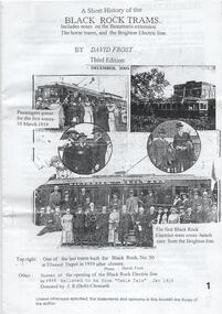
Pamphlet, David Frost, "A Short History of the Black Rock Trams", 2001
Single sheet of A4 white paper, printed both sides and folded to A5 size titled, and a A3 version, folded to A4 "A Short History of the Black Rock Trams", written by David Frost, 1st Edition, 2001. Printed by photocopying process. Published by the Sandringham and District Historical Society, has photographs, drawings, map and history of the tram line. The line was operated by the Victorian Railways.trams, tramways, black rock, vr, sandringham, melbourne, beaumaris -
 City of Kingston
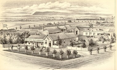
Photograph - Colour, Gregg's Hotel South Brighton
Gregg's Hotel in South Brighton was purchased by Barry Gregg in 1869 and continued to until 1925. Gregg had planned to create a health resort. This image first appeared in Alexander Sutherland's 'Victoria and Its Metropolis, Past and Present', 1888.Colour image of a drawing of Gregg's Hotel in South Brighton. South Brighton is now called Moorabbin. The drawing shows stables in the background with a field and a house behind that. The train line can be seen in the distance, with a train running along the tracks. -
 Williamstown Botanic Gardens- Hobsons Bay City Council
Postcard - Postcard – Williamstown Botanic Gardens, The Crown Studios, Sydney, c1900-1910
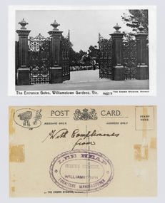
The cast iron gates (manufactured in Glasgow) introduced at the North West entrance in 1907. The gates were purchased from ‘Fairlie” corner of Acland and Anderson Streets, South Yarra at the cost of 72 pounds and cost 60 pounds to install. They had originally cost the owners of ‘Fairlie’ 1200 pounds. Lee Heap Furniture Warehouse of Williamstown used the postcards to advertise. The postcards are evidence of the interest the gardens held as a subject for postcard publishers. The text and images provide a snapshot into fashions, social interests and concerns of the time. The professionally produced images provide a pictorial history of Gardens including changing planting styles, various structures and features of the Gardens eg the aviary, cannons, the fountain, the second Curator’s Lodge and gates. The images offer an opportunity to compare garden vistas with the present day. The image in this postcard shows the gates intact and as installed in 1907. The current layout of this area still reflects the change of design, which followed the 1907 removal of the first gardener's residence and the subsequent re-organisation of this quarter of the gardens. This postcard is evidence of the placement of one of the cannons relocated from Fort Gellibrand in 1906. They were removed from the Gardens in the 1960s. These same cannons remain a feature on the Williamstown waterfront in 2013. Black and white image of main entrance gates which are open. Through the gates can be seen a man in waistcoat standing in front of a cannon. The gates are cast iron, double carriage gates with single pedestrian gates on either side and supported by four cast iron posts with ornamental finials. Front: ‘The Entrance Gates, Williamstown Gardens. Vic.’ ‘0457/2’ ‘THE CROWN STUDIOS, SYDNEY’. Reverse: Centre top ‘POST CARD’ with a logo in the middle of the words. Left top corner a drawing of an artist’s board and brushes with a camera in the centre. Left side ‘MESSAGE ONLY.’ Right side ‘ADDRESS ONLY.’ Top right corner inside a dotted rectangle ‘STAMP HERE’. Bottom on card ‘BY THE CROWN STUDIOS, SYNDEY.’ Under the vertical line down the middle line ‘Neither the Address not the Message must cross this line’. In ink ‘With Compliments / from’. An oval stamp with scalloped rim ‘LEE HEAP FURNITURE MANUFACTURER’ inside inner oval ‘FURNITURE WAREHOUSE, / WILLIAMSTOWN’.postcard, gardens, post-card, williamstown-botanic-gardens, hobsons-bay-city-council, entrance gates, entrance-gates, cast iron, finials, cannon, crown studios, lee heap furniture warehouse -
Bendigo Historical Society Inc.
Document - MARKS COLLECTION: PLAN OF CHIMNEY STACK
Unlabelled plan, drawing shows side view of chimney stack, '5 feet' written on base of chimney. Plan could be associated with a mine on New Chum Reef Line, Victoria Hill.bendigo, mining, chimney side section, chimney stack -
![1981 Warrnambool and District Community Information Directory front cover [.6]](/media/collectors/4f729f7797f83e030860184f/items/664fef1cdd0f9ab6b51abf51/item-media/66c27aa3202c41c4ca03b234/item-fit-380x285.jpg) Warrnambool and District Historical Society Inc.
Warrnambool and District Historical Society Inc.Booklet - Booklet Collection: City of Warrnambool Directory of Services, Collett and Bain
This is a collection of nine directories published by the City of Warrnambool dating from 1952 to 1992. They contain descriptions of the municipality and lists and details of services, social and community facilities for the period covered.These directories give snapshots of the City of Warrnambool for the years covered and will be useful for research.[.1] 16 pages printed with black and white photographs. The cover is cream card with writing in blue printing and the city of Warrnambool crest in the top left corner. [.2] 16 pages printed with black and white photographs. The cover is yellow card with writing in blue printing and the city of Warrnambool crest in the top left corner. [.3] 8 pages printed with pale yellow feathered design edges on either side of the text. The cover is cream with writing in Blue print and the pale yellow feathered pattern. A coloured City of Warrnambool seal is in the centre top third of the front cover. [.4] A single sheet of buff coloured light weight card folded in half to make a booklet. Black printing with a black Warrnambool crest in the top centre. [.5] 36 page booklet. The cover is of white shiny card with printed purple text. [.6] 96 page booklet. The cover has black printed text and red stylised cartoon like drawings representing different aspects of the community. [.7] 32 page booklet. The cover is of cream card printed with a 5mm wide green line across the front and back. Black ink drawings of Warrnambool landmarks by P Bryant feature on the cover and the Warrnambool City seal is in the bottom right hand corner. [.8] 20 page booklet of white paper with black text printing. There is a photo of the Tourist information centre on the rear cover. The Warrnambool city crest on the front cover which has a black geometrical edging design. [.9] 24 page booklet of white paper with black text printing. The front cover has the Warrnambool city crest in the top left hand corner and a photograph of the Lake Pertobe playground in the bottom two thirds. The back cover has a photo of the Warrnambool Saleyards. [.1] City of Warrnambool Victoria, Australia [.2] City of Warrnambool Victoria, Australia [.3] City of Warrnambool [.4] City of Warrnambool Organisations taking part in the Community Life of the City of Warrnambool 1952 [.5] Warrnambool Directory of Social Services [.6] Community Information Directory Warrnambool and District 1981 [.7] Community Information Guide 1991/1992 City of Warrnambool [.8] Citizens' Information Handbook for 1976-1977 [.9] Citizens' Information Handbook for 1977-1978 warrnambool, warrnambool city directory, warrnambool community organisations -
 Melbourne Tram Museum
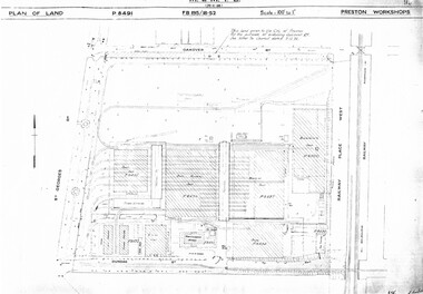
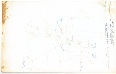
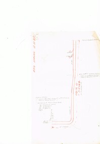
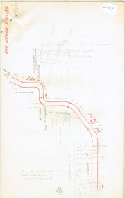
Drawing, Melbourne & Metropolitan Tramways Board (MMTB), "Preston Workshops", c1938
... layout and associated drawings including Reservoir railway line... Trams tramways Drawings Depots Property Preston Workshops ...Set of nine photocopied plans or drawings on A3 sheets of the "Preston Workshops" - c1939 .1 - P8491 - Plan of land showing layout and associated drawings including Reservoir railway line - 19-4-1939. .2 - P8492 - Plan of Timber stacks and Hall - 3-2-1939 .3 - P8493 - Plan of Offices and location of sub-station - 13-12-1938 .4 - P8494 - Plan of Store including Oil store - c1939. .5 - P8495 - Plan of Paint Shop and relationship to timber stack - 1-3-1939 .6 - P8496 - Plan of Car building and Repairs shop - 6-12-1938 .7 - P8497 - Plan of machine shop - 10-12-1938 .8 - P8500 - Plan of Blacksmiths shop - 1-12-1938 .9 - P8590 - Plan of Substation - 1-12-1938trams, tramways, drawings, depots, property, preston workshops, workshops, substation -
 Melbourne Tram Museum
Document - Report, David Frost, "A short history of the Black Rock Trams", Dec. 2003
Report or Research Report - 10 A4 pages, printed from 5 A3 sheets folded, titled "A short history of the Black Rock Trams", written by David Frost, 3rd Edition Dec. 2003. Includes notes on the Beaumaris extension, the horse trams and the Brighton Electric line. Photocopied from an original document. Includes a list of tram stops, map including the St Kilda Brighton Electric Street Railway, drawing of tram 36 and tickets, the tramcar fleet and a photo of the author on the rear page.trams, tramways, vr, beaumaris, black rock, st kilda brighton, horse trams, map -
 Melbourne Tram Museum
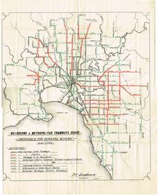
Map, Melbourne & Metropolitan Tramways Board (MMTB), "Proposals for General Scheme", 27/08/1923 12:00:00 AM
... Map - drawing with a line back, titled "Melbourne... Parliament Brighton Railways Map Map - drawing with a line back ...Map - drawing with a line back, titled "Melbourne and Metropolitan Tramways Board Proposals for General Scheme". Shows the proposed tram lines submitted to Parliament for the report into the General Scheme. Printed by Sands & McDougall Pty Ltd. Signed by J. P Strickland dated 27-8-1923. See Reg item 3374.2 for a better copy.trams, tramways, mmtb, general scheme, tramways, development, parliament, brighton, railways, map -
 Melbourne Tram Museum
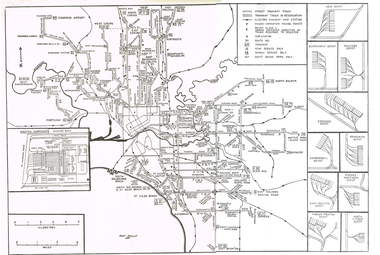
Map, Track plan or track map or layout of the Melbourne system, c1973
Track plan or track map or layout of the Melbourne system showing track layout, crossovers, depots, workshops and route numbers, terminus, substations, Bundy clocks, layout of Preston works. On the rear is a detailed layout of the city area. Shows railway stations but not the station names and rivers. Printed on cartridge paper. No details of to who prepared the plan or the drawing or date. Wattle Park line has been duplicated (Sept 1970), but the Essendon Airport line remains (closed Oct. 1976).trams, tramways, mmtb, track layout, junction, depots, substation, plans, trackwork, route numbers, terminus, map, bundy clock -
 Melbourne Tram Museum
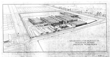
Drawing, Melbourne & Metropolitan Tramways Board (MMTB), "Melbourne & Metropolitan Tramways Board Preston Workshops", late 1920's?
Dyeline print of a perspective elevation of the MMTB Preston Workshops, titled "Melbourne & Metropolitan Tramways Board Preston Workshops", drawing No. W531. Shows the layout of the buildings, tracks, traversers, Thornbury Workshops, railway line and junction arrangements. In the bottom right hand corner is a draftsman's name "K. V. McGuiness". Scanned in a hi res format March 2016trams, tramways, mmtb, preston workshops, thornbury depot, drawings -
 Melbourne Tram Museum
Document - Research Notes, H. S. McComb, MTT & MTOCo authorised lines, c1956
Notes, 13 pages foolscap sheets pinned in the top left hand corner, 2 loose foolscap pages, 6 quarto pages, providing a sketch map of the MTOCo lines as authorised, length of each line, description, extract from surveyors level books for dates, list of cable car depots and financial notes. Items 2064 to 2075 within box 72.3 in a brown folder marked "MT&O Co." red pencil on the front cover.trams, tramways, mto co, cable trams, drawings, reports, surveys -
 Melbourne Tram Museum
Document - Research Notes, H. S. McComb, Details of Richmond line - Spencer St, Flinders St and Bridge Road, c1930
Notes, 9 pages, has been pinned together, giving details, opening dates, terminals, depot entries, sheave pits, curves, for the Richmond line - Spencer St, Flinders St and Bridge Road. Items 2064 to 2075 within box 72.3 in a brown folder marked "MT&O Co." red pencil on the front cover.trams, tramways, mto co, cable trams, drawings, reports, surveys, richmond, spencer st, flinders st, bridge rd -
 Melbourne Tram Museum
Document - Research Notes, H. S. McComb, Collins St to Brunswick St line, including the St Georges Road terminus at Barkly St, c1930
Notes,13 pages, pinned together, giving details, opening dates, terminals, depot entries, sheave pits, curves, for the Collins St to Brunswick St line, including the St Georges Road terminus at Barkly St. Items 2064 to 2075 within box 72.3 in a brown folder marked "MT&O Co." red pencil on the front cover.trams, tramways, mto co, cable trams, drawings, reports, surveys, collins st, gisborne st, brunswick st, st georges rd