Showing 8405 items matching "mckillops-bridge"
-
 Lakes Entrance Historical Society
Photograph, Judy Davies, Small blue album of North Arm bridge: Lakes Entrance Victoria, 2010
Small blue album containing twenty eight colour photographs of North Arm from bridge to Cabaritor Point showing new residential sites at Kalimna Victoriaengineering, historic site -
 Eltham District Historical Society Inc
Photograph, Looking west across Mount Pleasant Road Bridge, Research, c.1977, 1977c
Miscellaneous Bridges.Black and white photographmount pleasant road bridge, research (vic.) -
 Stawell Historical Society Inc
Photograph, Beasley’s Bridge on the Stawell to St Arnaud Road
Beasley’s Bridgestawell -
 Eltham District Historical Society Inc
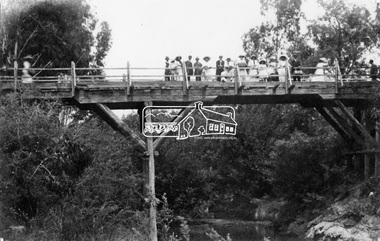
Negative - Photograph, Hurst's Bridge, c.1912
The area of Hurstbridge was originally known as Hurst’s-bridge after the timber bridge built over the Diamond Creek near Hurst’s station in late 1881/early 1882. A large group of people can be seen strolling across the timber bridge over the Diamond Creek on Hurstbridge-Arthurs Creek Road, Hurstbridge. It was built by John McDonald, of Arthur's Creek and was demolished and replaced in 1917 by a reinforced concrete arch bridge designed by John Monash.This photo forms part of a collection of photographs gathered by the Shire of Eltham for their centenary project book, "Pioneers and Painters: 100 years of the Shire of Eltham" by Alan Marshall (1971). The collection of over 500 images is held in partnership between Eltham District Historical Society and Yarra Plenty Regional Library (Eltham Library) and is now formally known as 'The Shire of Eltham Pioneers Photograph Collection.' It is significant in being the first community sourced collection representing the places and people of the Shire's first one hundred years.Digital image 4 x 5 inch B&W Negshire of eltham pioneers photograph collection, 1912, bridge, diamond creek (creek), hurstbridge, hurst's bridge -
 Eltham District Historical Society Inc
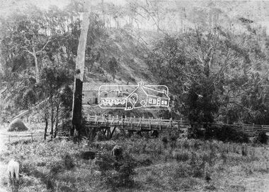
Negative - Photograph, Hurst's Bridge, 1885
Looking northwest onto the first bridge at Hurstbridge, 1885. The area of Hurstbridge was originally known as Hurst’s-bridge after the timber bridge built over the Diamond Creek near Hurst’s station in late 1881/early 1882 on the Hurstbridge-Arthurs Creek Road, Hurstbridge. It was built by John McDonald, of Arthur's Creek and was demolished and replaced in 1917 by a reinforced concrete arch bridge designed by John Monash. Cross Reference Photo No.(s): 1012/1013This photo forms part of a collection of photographs gathered by the Shire of Eltham for their centenary project book,"Pioneers and Painters: 100 years of the Shire of Eltham" by Alan Marshall (1971). The collection of over 500 images is held in partnership between Eltham District Historical Society and Yarra Plenty Regional Library (Eltham Library) and is now formally known as the 'The Shire of Eltham Pioneers Photograph Collection.' It is significant in being the first community sourced collection representing the places and people of the Shire's first one hundred years.Digital image 4 x 5 inch B&W Negshire of eltham pioneers photograph collection, hurstbridge, bridge, diamond creek (creek), hurst's bridge -
 Eltham District Historical Society Inc
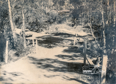
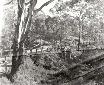
Photograph, Old Bridge, Kaylock's Crossing, Brougham Street, Eltham, c.1895
Brougham Street was created in Josiah Holloway's 1851 subdivision of Little Eltham. It was one of several east-west streets shown on the subdivision plan as crossing the Diamond Creek. The western part was named Wellington Street on the subdivision plan but was later changed to conform with the name of the eastern part as acknowledgement of the continuity of the street. It is not known when the first bridge was constructed in Brougham Street however it was certainly mentioned at Council’s meeting of 2 June 1884 as being in a dangerous state of repair. This photo (c.1895) of an old bridge shows a very low-level simple log girder bridge crossing the creek at a right angle and so the approaches involved bends in the road alignment. This bridge was generally known as Kaylocks Bridge or Kaylock’s Crossing after the owner of the adjoining land. It was most likely built from around the mid-1850s, or a crossing of some fashion established as Richard George Kaylock, butcher of Little Eltham and his wife Emily Ann settled there in 1854. His property was in Wellington Street (now Brougham Street) and apparently extended across the Diamond Creek. The land on the western side of the creek was farmed, the house being on the eastern side. Kaylock's Bridge formed part of the original coach road to Eltham and in 1922 was described as an "old rustic bridge". Its low level and insubstantial construction made it susceptible to flood damage, necessitating frequent closures until repairs could be carried out. In September 1922, Council called for tenders for a new timber bridge to be constructed at Kaylock’s crossing. An engineering assessment carried out for the Council by Macleod Consulting at the time of the replacement suggested that the construction details indicate that it was in the 1900s, however this dating could possibly have been the result of numerous repairs undertaken over the years to flood damage. The tender was awarded to Mr Weller of Kangaroo Ground who commenced work in February 1923 on a higher-level timber trestle bridge. Work was slowed due to illness of the contractor and the accidental death of a man in March 1923 following the collapse of the bank after he had jumped into a hole that had just been blasted. The bridge was completed around July 1923 at which point the old structure was pulled up, marking what was described in the ‘Advertiser’ newspaper as the passing of an old and well-loved landmark in the district. In April 1924 the approach to Kaylocks bridge was washed away during the heavy flooding that destroyed the Main Road bridge. The western side was repaired, and an extra span was added to the eastern side using timber from the destroyed Main Road bridge. The bridge was again severely damaged four months later in August 1924 When a lack of finances delayed repairs to the Bridge Street bridge in 1931 (also referred to as Obelisk Bridge at the time), traffic had to detour via Brougham Street for some time. Local residents feared that the Bridge Street bridge might never reopen. Kaylocks Bridge was constantly subject to damage by floods. In the 1934 flood it was submerged by two feet of water. In more recent times the bridge was again severely damaged by flooding and repairs made. A new bridge and adjoining footbridge were constructed in 2009. Part of a slide show presentation "Bridges & Waterways of the Shire" by Russell Yeoman to the 13 September 1989 Society meeting. The presentation included slides of historic photos from the Shire of Eltham Pioneers collections as well as several recent views.Photo of earliest known crossing of the Diamond Creek at brougham StreetPostcard photo printbrougham street, eltham, wellington street, kaylocks bridge, bridge, diamond creek (creek) -
 Lakes Entrance Historical Society
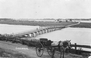
Postcard - North Arm bridge. Lakes Entrance Victoria c1900, Cooper Alexander, 1900c
CunninghameSepia coloured postcard of first bridge over North Arm, showing view of town buildings, including Club Hotel; sand hummocks; Cunninghame Arm; die back of melaleuca on sand flats. In foreground post and rail fence beside road, two wheeled horse drawn vehicle, jinker, with grey horse standing in shafts. Ten or eleven people standing on bridge. Lakes Entrance Victoriatopography, bridges, transport -
 Eltham District Historical Society Inc
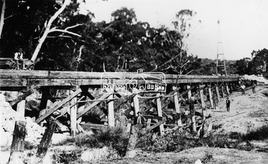
Photograph, Railway Bridge construction between Eltham and Hurstbridge, c.1912
The railway was extended from Eltham to Hurstbridge in 1912. This bridge is most likely near Allendale Road, Diamond Creek. It was one of four original trestle bridges in the stretch north of Allendale Road, which were all burnt out in January 1969 (replaced by two steel bridges and two corrugated iron culverts).This photo forms part of a collection of photographs gathered by the Shire of Eltham for their centenary project book,"Pioneers and Painters: 100 years of the Shire of Eltham" by Alan Marshall (1971). The collection of over 500 images is held in partnership between Eltham District Historical Society and Yarra Plenty Regional Library (Eltham Library) and is now formally known as the 'The Shire of Eltham Pioneers Photograph Collection.' It is significant in being the first community sourced collection representing the places and people of the Shire's first one hundred years.Digital image One 4 x 5 inch B&W negative One 9 x 12.5 cm printshire of eltham pioneers photograph collection, hurstbridge, allendale road, hurstbridge railway extension, railway bridge, railway line construction, trestle bridge, diamond creek (creek) -
Malmsbury Historical Society
Photograph (Item), Malmsbury Gutters Near Coliban Bridge, Malmsbury ca1990
Buildings - Coliban Bridge -
 Hume City Civic Collection
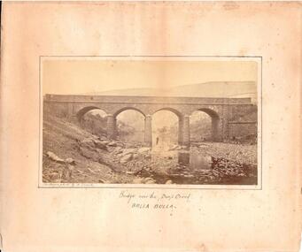
Photograph, c. 1870s - 1880s
The phtograph was taken by Alfred Sinel who was the local photgrapher in Sunbury. The four arched bridge spans the river at Deep Creek, Bulla. The bridge replaced the forde crossing which is in the foreground of the photograph. Alfred Sinel is listed in the 1874 rate book as a photographer - artist.A mounted sepia photograph of the four-arched bluestone bridge over Deep Creek at Bulla. A man is standing under the 3rd arch from the LHS. The cream mount has a ruled ink frame around the photo. The caption has been hand-written under the photograph.BRIDGE OVER THE DEEP CREEK / BULLA BULLAdeep creek, bridges, bulla, sunbury, sinel, alfred, photographers, george evans collection -
 Eltham District Historical Society Inc
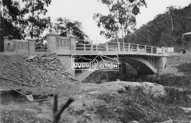
Negative - Photograph, New bridge at Hurstbridge, 1917
The newly constructed re-inforced concrete arched bridge across the Diamond Creek at Hurstbridge designed by John Monash. Eltham Shire shared the cost of the construction of the bridge with Heidelberg and Whittlesea Shires. The bridge was officially opened on 3rd November 1917. Part of a slide show presentation "Bridges & Waterways of the Shire" by Russell Yeoman to the 13 September 1989 Society meeting. The presentation included slides of historic photos from the Shire of Eltham Pioneers collections as well as several recent views.This photo forms part of a collection of photographs gathered by the Shire of Eltham for their centenary project book, "Pioneers and Painters: 100 years of the Shire of Eltham" by Alan Marshall (1971). The collection of over 500 images is held in partnership between Eltham District Historical Society and Yarra Plenty Regional Library (Eltham Library) and is now formally known as 'The Shire of Eltham Pioneers Photograph Collection.' It is significant in being the first community sourced collection representing the places and people of the Shire's first one hundred years.Digital image 4 x 5 inch B&W Negshire of eltham pioneers photograph collection, hurstbridge, bridge, 1917, diamond creek (creek), monash bridge -
 Phillip Island and District Historical Society Inc.
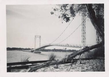
Photograph, 1940's
One of a collection of 9 photographs donated by F. WinnBlack & White photograph of the old Suspension Bridge at San Remo. Newhaven on other side of bridge.On back: "San Remo Bridge"san remo suspension bridge, phillip island suspension bridge, bridges, f winn -
 Eltham District Historical Society Inc
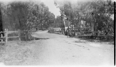
Postcard - Photograph postcard, Old Bridge, Kaylock's Crossing, Brougham Street, Eltham, c.1912
Date estimated to be circa 1912 based on the style of printing on the reverse of the card - Kodak Austral paper for real photo postcards, the paper was manufactured c.1908-1914 (See also POSTCARDS ON KODAK PAPER - IS IT POSSIBLE TO "DATE" THEM? http://tps.org.au/bb/viewtopic.php?t=115) Brougham Street was created in Josiah Holloway's 1851 subdivision of Little Eltham. It was one of several east-west streets shown on the subdivision plan as crossing the Diamond Creek. The western part was named Wellington Street on the subdivision plan but was later changed to conform with the name of the eastern part as acknowledgement of the continuity of the street. It is not known when the first bridge was constructed in Brougham Street however it was certainly mentioned at Council’s meeting of 2 June 1884 as being in a dangerous state of repair. This photo (c.1895) of an old bridge shows a very low-level simple log girder bridge crossing the creek at a right angle and so the approaches involved bends in the road alignment. This bridge was generally known as Kaylocks Bridge or Kaylock’s Crossing after the owner of the adjoining land. It was most likely built from around the mid-1850s, or a crossing of some fashion established as Richard George Kaylock, butcher of Little Eltham and his wife Emily Ann settled there in 1854. His property was in Wellington Street (now Brougham Street) and apparently extended across the Diamond Creek. The land on the western side of the creek was farmed, the house being on the eastern side. Kaylock's Bridge formed part of the original coach road to Eltham and in 1922 was described as an "old rustic bridge". Its low level and insubstantial construction made it susceptible to flood damage, necessitating frequent closures until repairs could be carried out. In September 1922, Council called for tenders for a new timber bridge to be constructed at Kaylock’s crossing. An engineering assessment carried out for the Council by Macleod Consulting at the time of the replacement suggested that the construction details indicate that it was in the 1900s, however this dating could possibly have been the result of numerous repairs undertaken over the years to flood damage. The tender was awarded to Mr Weller of Kangaroo Ground who commenced work in February 1923 on a higher-level timber trestle bridge. Work was slowed due to illness of the contractor and the accidental death of a man in March 1923 following the collapse of the bank after he had jumped into a hole that had just been blasted. The bridge was completed around July 1923 at which point the old structure was pulled up, marking what was described in the ‘Advertiser’ newspaper as the passing of an old and well-loved landmark in the district. In April 1924 the approach to Kaylocks bridge was washed away during the heavy flooding that destroyed the Main Road bridge. The western side was repaired, and an extra span was added to the eastern side using timber from the destroyed Main Road bridge. The bridge was again severely damaged four months later in August 1924 When a lack of finances delayed repairs to the Bridge Street bridge in 1931 (also referred to as Obelisk Bridge at the time), traffic had to detour via Brougham Street for some time. Local residents feared that the Bridge Street bridge might never reopen. Kaylocks Bridge was constantly subject to damage by floods. In the 1934 flood it was submerged by two feet of water. In more recent times the bridge was again severely damaged by flooding and repairs made. A new bridge and adjoining footbridge were constructed in 2009.Digital file only Postcards scanned from the collection of Michael Aitken on loan to EDHS, 2 Sep. 2022michael aitken collection, eltham, postcards, bridge, brougham street, diamond creek (creek), kaylocks bridge, wellington street -
 Ringwood and District Historical Society
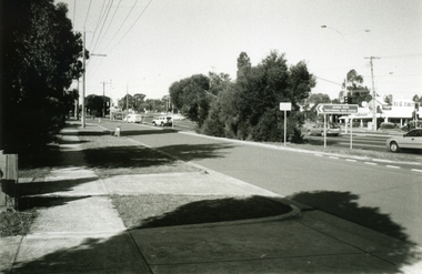
Photograph, Joan Walker, East Ringwood 2000 - Burnt Bridge taken from Maroondah Highway just near Kalinda Road, 2000
East Ringwood 2000 - Burnt Bridge Shopping Centre taken from Maroondah Highway just near Kalinda Road - B&W Photo from Album 6501 -
 Buninyong & District Historical Society
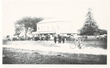
Photograph - Photograph of Original Photograph, Corduroy Bridge Hotel, 1906, 1988
Building historyB/W photo of original photo of Corduroy Bridge Hotel, High St. Clarendon, circa 1906, at date of auction, showing Midland Highway, people, buggies and carts.Identification on reverse.corduroy bridge hotel, clarendon, high street -
 Tarnagulla History Archive
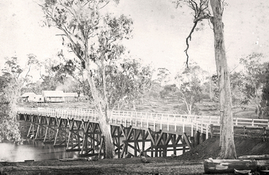
Photograph of the newly completed bridge at Newbridge, Victoria, c.1894, The newly completed bridge at Newbridge, Victoria, c.1894, 1894
Murray Comrie Collection. This photograph is a well-preserved original. Monochrome photograph depicting the newly completed wooden bridge at Newbridge, Victoria. Position of photographer is on the east bank of the Loddon, looking west toward the present day Newbridge Pub.newbridge, bridge, loddon river, infrastructure, construction, roads, businesses, buildings -
 Eltham District Historical Society Inc
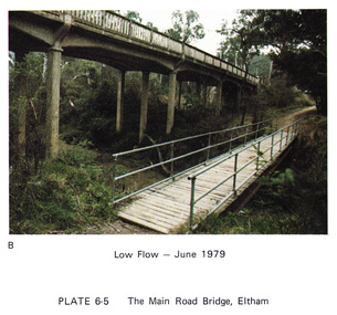
Work on paper (Sub-Item) - Photograph, Main Road Bridge, Eltham low flow of Diamond Creek, June 1979
Colour photograph.Main Road Bridge, Eltham low flow of Diamond Creek with wooden pedestrain bridge constructed over the creek as a continuation of the walking and biking trail, June 1979diamond creek, eltham, bridge, main road, pedestrain bridge, trail -
![Newspaper Clipping - Digital Image, Bridge-over-rail job to cost $254,000, 1974 [Main Street Greensborough], 24/09/1974](/media/collectors/4f729f5697f83e03086015b8/items/5eb5f55721ea671f1807c4cf/item-media/5eb5f5e021ea671f18088f90/item-fit-380x285.jpg) Greensborough Historical Society
Greensborough Historical SocietyNewspaper Clipping - Digital Image, Bridge-over-rail job to cost $254,000, 1974 [Main Street Greensborough], 24/09/1974
In 1974 the proposed road over rail bridge in Main Street Greensborough was estimated to cost $254,000. The reconstruction of the bridge was necessary for the duplication of the rail line between Macleod and Greensborough.News clipping, black and white text. hurstbridge rail line, greensborough station, main street greensborough -
 Greensborough Historical Society
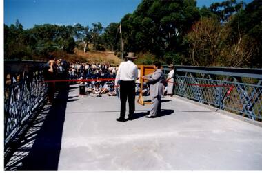
Photograph - Digital Image, Anne Paul, Opening of restored Old Lower Plenty Bridge 2001, 14/03/2001
The opening of the restored Old Lower Plenty Bridge, opened on 14/03/2001 by the Minister for Environment and Conservation Sherryl Garbutt MLA and Mayor of Banyule Cr Dale Peters. The project was jointly funded by Banyule Council and Parks Victoria. The restored bridge is the oldest remaining bridge in the former Shire of Eltham and forms part of the Plenty River Trail.Digital copy of colour photographlower plenty, lower plenty bridge, sherryl garbutt, dale peters, banyule council, parks victoria -
 Eltham District Historical Society Inc
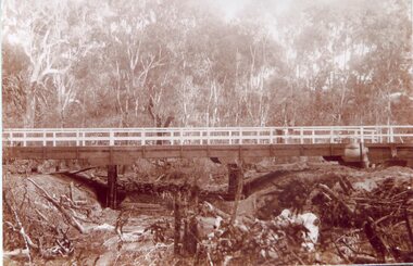
Negative - Photograph, J.A. McDonald, One Tree Hill Road Bridge, Christmas Hills, 2 July 1962
One Tree Hill Road Looking south 2/7/62 The bridge was destroyed by bushfires 15-16 January 1962. A temporary bridge was set up to the east sideRecord of various Shire of Eltham infrastructure works undertaken during the period of 1952-1962 involving bridge and road reconstruction projects, sometimes with Eltham Shire Council Project Reference numbers quoted. It was during this period that a number of significant improvements were made to roads and new bridges constructed within the shire that remain in place as of present day (2022). In many situations, the photos provide a tangible visible record of infrastructure that existed throughout the early days of the Shire. The album was put together by or under the direction of the Shire Engineer, J.A. McDonald.1962-07-02, bridge construction, christmas hills, infrastructure, shire of eltham, victorian bushfires - 1962, bush fires, one tree hill road, property damage -
 Eltham District Historical Society Inc
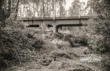
Photograph, Russell Yeoman, Yarra Glen Road Bridge over Watsons Creek, Kangaroo Ground, c.1970, 1970c
Concrete bridge built in the 1920s.Roll of 35mm black and white negative film, 4 of 7 stripsIlford HP4bridge, bridges, watsons creek, eltham-yarra glen road, yarra glen road, kangaroo ground -
 Stawell Historical Society Inc
Photograph, Salt Creek Bridge 1993 -- Coloured
Salt Creek Bridge 1993stawell -
 Stawell Historical Society Inc
Photograph, Mokepilly Bridge 1908 -- Postcard
Mokepilly Bridge 1908 Postcardstawell -
 Wonga Park Community Cottage History Group
Photograph (Item) - Black and White, Wonga Park: Old Jumping Creek Bridge, c. 1931
Old Jumping Creek BridgePhoto is named 14880026.jpg on CD -
 Halls Gap & Grampians Historical Society
Photograph - Coloured, C 1980s (?)
Photo shows old wooden rail bridge curved up and over a creek. A man is standing on bridge looking down, a woman is kneeling behind man and is also looking down. Tree branches are leaning over bridge.'Old rail bridge"structures, bridges, trains -
 National Vietnam Veterans Museum (NVVM)
Photograph, Gibbons, Denis, National Route 23 Bridge
Denis Gibbons (1937 – 2011) Trained with the Australian Army, before travelling to Vietnam in January 1966, Denis stayed with the 1st Australian Task Force in Nui Dat working as a photographer. For almost five years Gibbons toured with nine Australian infantry battalions, posting compelling war images from within many combat zones before being flown out in late November 1970 after sustaining injuries. The images held within the National Vietnam Veterans Museum make up the Gibbons Collection. A black and whitie photograph of a series of South Vietnamese Regional Force heavily sandbagged outposts on Vietnams National Route 23, built around both approaches to a second bridge built by 1st Field Sqn Engineers of the 1st Australian Task Force soldiers had the responsibility for protecting the bridge against NVA/VietCong attack. The Regional Force soldiers living in these outposts normally had their families, wives and children, living with them.photograph, south vietnamese regional force, national route 23, 1st field sqn engineers, 1st atf base, gibbons collection catalogue, regional force soldiers, australian soldiers, nva/vietcong, denis gibbons -
 Eltham District Historical Society Inc
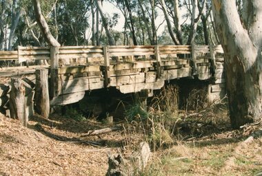
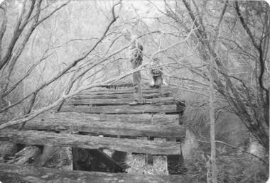
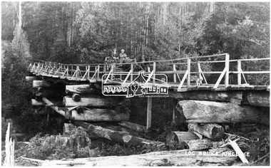
Negative - Photograph, Log bridge over Pheasant Creek, Kinglake, c.1920
Horse and cart with driver Mr. F. Thomson and passenger cross a wooden bridge with log tree trunk base construction supported by timber rails over Johnstone's Creek amidst the Kinglake forest. The bridge was built for the timber tramline. There was also a logging district in the Pheasant Creek area just outside the Shire of Eltham. Note dog also sitting on bridge.This photo forms part of a collection of photographs gathered by the Shire of Eltham for their centenary project book,"Pioneers and Painters: 100 years of the Shire of Eltham" by Alan Marshall (1971). The collection of over 500 images is held in partnership between Eltham District Historical Society and Yarra Plenty Regional Library (Eltham Library) and is now formally known as 'The Shire of Eltham Pioneers Photograph Collection.' It is significant in being the first community sourced collection representing the places and people of the Shire's first one hundred years.Digital image 4 x 5 inch B&W Neg 120 format B&W negative (spare) 2 x printsbridge, f. thomson, kinglake, log bridge, mr. munro, pheasant creek, pioneers and painters, shire of eltham pioneers photograph collection, timber tramway -
 Melbourne Tram Museum
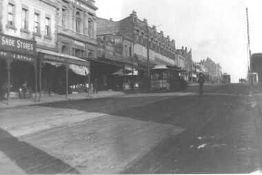
Photograph, Cable tram 41 Bridge Road Richmond, c1900
The photograph shows cable, trailer 41 climbing the Bridge Road hill just west of Waltham Steet bound for the city. A second cable set can be seen in the distance, bound for Hawthorn Bridge. Nearly all of the buildings on this south side of Bridge Road remain today including the former Forbes and Sons building. Photo possibly dated c1900.Yields information about cable trams in Bridge Road Richmond and associated buildings.Photograph, black and white, plain papertrams, tramways, cable tram, bridge road, tram 41, richmond -
 Phillip Island and District Historical Society Inc.
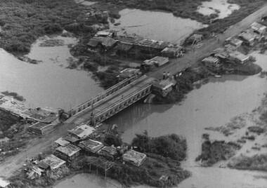
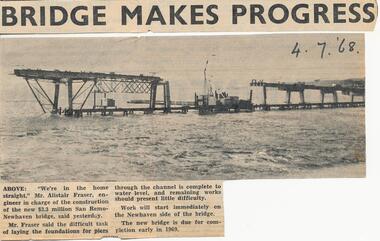
Newspaper clippings, 04/07/1967
Collection of newspaper clippers in scrap book dated 1960 - 1973Newspaper article concerning the building of new bridge Phillip Island - San Remo; foundations laid in channel; photograph of bridge in construction."Bridge makes progress"local history, newspapers, jean jamieson, phillip island new bridge from san remo -
 Eltham District Historical Society Inc
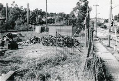
Photograph, Para Road Bridge construction, Briar Hill, near Greensborough, c.1971, 1971c
Three black and white photographs; two showing construction works of the bridge over the Plenty River at Briar Hill and one of Greensborough Park, Grimshaw Street, summer 1971-1972greensborough, briar hill, para road, bridges, construction, plenty river