Showing 14765 items
matching north road
-
 Eltham District Historical Society Inc
Photograph - Aerial Photograph, Landata, Eltham, Vic, Apr. 1963
... and Bible streets bounded by Elsa Court to north, Main Road Bridge... and Bible streets bounded by Elsa Court to north, Main Road Bridge ...Centred on present day John Street, Eltham between Main and Bible streets bounded by Elsa Court to north, Main Road Bridge to south, Wattle Grove to east and Bolton Street to west. Historic Aerial Imagery Source: Landata.vic.gov.au Aerial Photo Details: Project No :486 Project : MELBOURNE (1963) PROJECT Run : 6 Frame : 123 Date : 04/1963 Film Type : B/W Camera : RC8 Flying Height : 5100 Scale : 9600 Film Number : 1805 GDA2020 : 37°43'12"S, 145°08'54"E MGA2020 : 336800, 5823623 (55) Melways : 21 J6 (ed. 42)aerial photo, neil webster collection, 1963-04, bolton steet, elsa court, eltham, john street, main road, main road bridge, melway 21j6, wattle grove -
 Eltham District Historical Society Inc
Photograph - Aerial Photograph, Landata, Eltham, Vic, Apr. 1963
... bounded by Elsa Court to north, Main Road to south, Bible Street... bounded by Elsa Court to north, Main Road to south, Bible Street ...Centred on present day Eltham Ridge, Bolton Street, Eltham bounded by Elsa Court to north, Main Road to south, Bible Street to east and Reichelt Avenue and Rattray Road to west. Historic Aerial Imagery Source: Landata.vic.gov.au Aerial Photo Details: Project No :486 Project : MELBOURNE (1963) PROJECT Run : 6 Frame : 124 Date : 04/1963 Film Type : B/W Camera : RC8 Flying Height : 5100 Scale : 9600 Film Number : 1805 GDA2020 : 37°43'12"S, 145°08'16"E MGA2020 : 335876, 5823604 (55) Melways : 21 G6 (ed. 42)aerial photo, neil webster collection, 1963-04, bible street, bolton street, eltham, eltham ridge, main road, montmorency, rattray road, reichelt avenue -
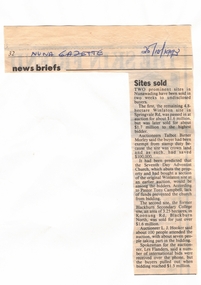 Whitehorse Historical Society Inc.
Article, Sites sold, 25/10/1993 12:00:00 AM
... in Koonung Road, Blackburn North.... blackburn secondary college koonung road blackburn north talbot ...Report of two prominent sitesReport of two prominent sites in Nunawading having been sold to undisclosed buyers. The first was the remaining 4.8 hectare Winlaton site in Springvale Road and the second site was the former Blackburn Secondary College site, an area of 3.25 hectares in Koonung Road, Blackburn North.Report of two prominent sites land sales, winlaton, springvale road, nunawading, blackburn secondary college, koonung road, blackburn north, talbot, birner, morley (auctioneer), seventh day adventist church, campbell, tony (pastor), l. j. hooker -
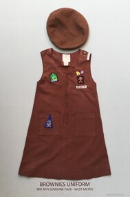 Sunshine and District Historical Society Incorporated
Brownies Uniform - 3rd North Sunshine, Early 1980's
... Sunshine Brownies were located in Furlong Road, North Sunshine 3020... in Furlong Road, North Sunshine 3020 (Melway 26 G6). This brown ...Prior to 1996 young girls (7 - 11years) in the Girl Guide Association were known as Brownies. About circa 1983 this beret and dress were worn by a girl named Rebecca who was a member of the 3rd North Sunshine Pack - West Metro region. The 3rd North Sunshine Brownies were located in Furlong Road, North Sunshine 3020 (Melway 26 G6).This brown uniform is a historic reminder that at one stage Brownies existed as part of the Girl Guide Association.Two clothing items: (a) Beret - Brown woollen beret with a sewn on Brownies cloth badge. (b) Dress - Brown sleeveless cotton dress with 2 metal badges attached and 6 sewn on cloth badges.3rd Nth Sunshine Pack - West Metro, 19 April Action 83, Venture, Footpathbrownies uniform, 3rd north sunshine, 1983 april action, furlong road, venture, footpath, brownies beret, brownies dress -
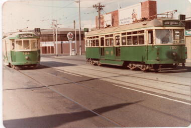 Melbourne Tram Museum
Photograph - Set of two photographs - Union Road - Ascot Vale VR700 and L104, 1-3-1980
... is on the Showgrounds siding, with tram 700 in Union Road, just to the north..., with tram 700 in Union Road, just to the north of Epsom Road ...Set of two colour photos showing VR class tram 700 and L class 104 on the ARHS & TMSV tour 1-3-1980. L104 is on the Showgrounds siding, with tram 700 in Union Road, just to the north of Epsom Road. In the background are Showgrounds buildings and a Caltex Service Station. In the second photo, W5 685 inbound to the city is seen between the two trams. Yields information the history of ARHS and TMSV tours.Set of two colour prints on Kodak paper, dated Mar. 1980tramways, trams, vr class, w5 class, tram 700, tram 104, tours, tram 685, l class, showgrounds -
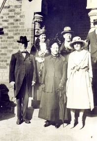 Whitehorse Historical Society Inc.
Photograph, Wakefield family
... and a cottage on the Springfield Village Estate, Springfield Road..., Springfield Road, Blackburn North. wakefield john rhoda wakefield ...John Wakefield Snr. migrated to Australia in 1852, as a crewman. Elizabeth, John, Tom and George arrived in 1854. In 1859 John Wakefield Jnr. married Rhoda Hartnett. They purchased land and a cottage on the Springfield Village Estate, Springfield Road, Blackburn North.Sepia photograph of a group of six people at a wedding. John and Rhoda Wakefield are at front - left and centre.wakefield, john, rhoda, wakefield family -
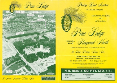 Ringwood and District Historical Society
Flyer, Land Auction Sale Brochure, Pine Lodge, Ringwood North, Victoria - 1977
... Road, Ringwood North. Auction date, Saturday, 4th June, 1977... Road Ringwood North melbourne Refer also to Reg. No. 5172 ...Refer also to Reg. No. 5172 for Pine Lodge Land Auction 3rd release, 1978.Yellow double-sided real estate auction notice with green print showing aerial photograph and map of subdivision layout and summary of local features and services for Pine Lodge, Kalinda Road, Ringwood North. Auction date, Saturday, 4th June, 1977, at 2:30pm.Subdivision plan includes Parkgate Drive, Wood-Church Close, and Pensby Court. (Agent) N.R. Reid & Co. Pty. Ltd., Safeway Centre, Boronia Road, Boronia (Phone) 762 1022, 450 Little Collins Street, Melbourne (Phone) 67 1746, and 207 Stud Road, Wantirna South (Phone) 231 2277. -
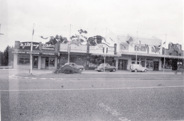 Whitehorse Historical Society Inc.
Photograph, Ted Tudor's Shop, C.1950s
... Road, Mitcham. North side - Corner Britannia Street. Circa... Road, Mitcham. North side - Corner Britannia Street. Circa 1950 ...Black and white photo of Ted Tudor's Shop - 24 Whitehorse Road, Mitcham. North side - Corner Britannia Street. Circa 1950's, in order from left - Blayney (Butcher) - Milburne (Greengrocer) - Tudor (Draper) - Jay (Florist) - Riches (Barber) - Scott - (Ironmonger).tudor, ted, russell, alexander, stan russell menswear. -
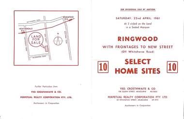 Ringwood and District Historical Society
Flyer, Auction sale brochure advertising home sites with frontages to New Street, Ringwood, Victoria - 1961
... , north of Palmerston Road. Auctioneers in conjunction - Yeo... Road Ringwood North melbourne Location map showing land ...Advertisement for Sub-divisional sale by auction on Saturday, 22nd April, 1961, with terms of sale of 10 home sites with frontages to New Street, Ringwood, Victoria.Location map showing land for sale on New Street, Ringwood, north of Palmerston Road. Auctioneers in conjunction - Yeo, Crosthwaite & Co., 108 Queen Street Melbourne (Telephone) MU 8605, and Perpetual Realty Corporation Pty. Ltd., 62 Swanston Street, Melbourne (Telephone) MF 3721. -
 Eltham District Historical Society Inc
Photograph - Aerial Photograph, Landata, Eltham, Vic, Apr. 1972
... Leisure Centre bounded by Central Park to north, Main Road... Leisure Centre bounded by Central Park to north, Main Road ...Centred on present day Diamond Creek Trail at the Eltham Leisure Centre bounded by Central Park to north, Main Road at Falkiner Street to south, MacMahon Ball Paddock to east and Grand Boulevard at Buena Vista Drive to west. Historic Aerial Imagery Source: Landata.vic.gov.au Aerial Photo Details: Project No :985 Project : MELBOURNE 1972 Run : 28 Frame : 207 Date : 04/1972 Film Type : B/W Camera : RC10 Flying Height : 5700 Scale : 9600 Film Number : 2635 GDA2020 : 37°43'25"S, 145°08'20"E MGA2020 : 335985, 5823223 (55) Melways : 21 G7 (ed. 42)aerial photo, neil webster collection, 1972-04, eltham, buena vista drive, central park, diamond creek trail, eltham leisure centre, falkiner street, grand boulevard, macmahon ball paddock, main road, melway 21g7 -
 Glenelg Shire Council Cultural Collection
Negative - Glass Plate Negative - Bentinck Street south (Cape Nelson Road), c. 1890
... (Cape Nelson Road) looking north from near Must Street... Cliff Street Portland great-ocean-road Glass plate negative ...Glass plate negative. Image shows Bentinck Street south (Cape Nelson Road) looking north from near Must Street. 'Burswood' obscured by trees on right. Large building on right below horizon line is Drill Hall. Man in horse and buggy left foreground. -
 Melbourne Tram Museum
Slide, Les Fordham, Dec. 1963
... by Les Fordham of a view looking north in St Kilda Road from... of a view looking north in St Kilda Road from the Arts Centre tram ...hanimount light brown 35mm slides - December 1963 taken by Les Fordham of a view looking north in St Kilda Road from the Arts Centre tram stop with a W5 route 16 in bound and a W2 outbound. Has in the background adverts for Olympic Tyres and Coca Cola.trams, tramways, st kilda rd, route 16, w5 class, w2 class -
![Book - Novel, Schwarz, Bruno, Scarlet on gold, [n.d.] [1954?]](/media/collectors/641920217f0478323d8a47a8/items/654319bbf11bd0375b7d3cbc/item-media/654f0221e64ed8bdfc17eb09/item-fit-380x285.jpg) Linton Mechanics Institute and Free Library Collection
Linton Mechanics Institute and Free Library CollectionBook - Novel, Schwarz, Bruno, Scarlet on gold, [n.d.] [1954?]
... , Charlton'; 'Roundabout Books, 55E Kooyong Road, North Caulfield'; E..., Charlton'; 'Roundabout Books, 55E Kooyong Road, North Caulfield'; E ...Action/adventure story.144 p. ; red cover with image of French Foreign Legionnaire riding a horse and wielding a sword (section of original dust jacket which has been pasted to front cover).fictionAction/adventure story.fiction, adventure stories -
Ballarat Heritage Services
Photograph, Birthday Party, 1969, c1969
... home, 93 Willsmere Road, North Kew (behind North Kew Newsagency... of Clare Gervasoni at her home, 93 Willsmere Road, North Kew ...Five girls celebrate the birthday of Clare Gervasoni at her home, 93 Willsmere Road, North Kew (behind North Kew Newsagency). A cake featurers seven lit candles, there are Marchants Lemonade bottles and a bowl of jelly on the table. Most of the girls wear the uniform of St Anne's East Kew, and an apron. Left to right: ? Martina ?, Clare Gervasoni, Brigid DeNeefe, Yvonne Brosolo (cut off) birthday, clare gervasoni, brigid deneefe, st anne's east kew uniform -
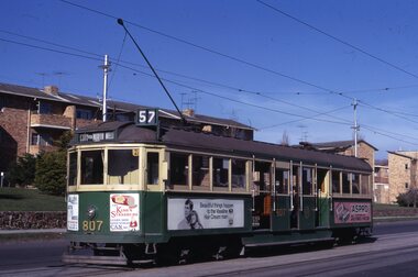 Melbourne Tram Museum
Slide, Keith Kings, 7/07/1969 12:00:00 AM
... via North Melbourne in Union Road at cnr of Geddes St, 7/7... Trams tramways W5 class Union Road Route 57 City via North ...35mm Kodak white cardboard colour slide by Keith Kings of - W5 807, fitted with square windshields on a route 57, City via North Melbourne in Union Road at cnr of Geddes St, 7/7/1969. Trams adverts for Aspro, Vaseline Hair Cream, Kings StrasburgKeith Kings stamp and number "56-26", with details of exposure. in ink "MMTB W5 with square cornered glass windshield, Union Road, cnr Geddes St Ascot Vale 7/7/69"trams, tramways, w5 class, union road, route 57, city via north melbourne, tram 807 -
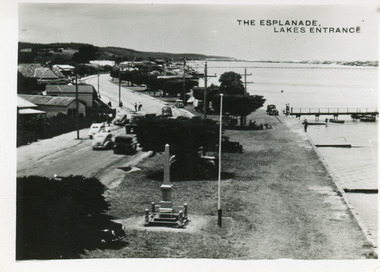 Lakes Entrance Historical Society
Postcard - Esplanade Lakes Entrance, 1945c
... on north side of road, Princes Highway, which follows the margin... 1922 on the grass verge between road and lake. Trimmed WW1 ...Original from wallet of miniature postcards produced by Bulmer, two copies. 01419.1 and .2 Also two enlargements 17 x 25 cmBlack and white small format postcard of Esplanade, taken from the WW2 Air Observers Spotting Tower. In the foreground is the Cenotaph erected 1922 on the grass verge between road and lake. Trimmed WW1 Cypress trees also on verge. Cars and truck on highway all travelling in easterly direction. Houses and businesses on north side of road, Princes Highway, which follows the margin of the lake shore. Lakes Entrance VictoriaThe Esplanade Lakes Entrancetownship, waterfront, transport, world war 1939 - 1945, world war 1914-1918 -
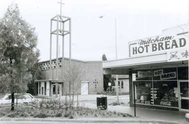 Whitehorse Historical Society Inc.
Photograph, Corner Edward Street & Whitehorse Road, Mitcham, 2000
... of Edward Street & Whitehorse Road looking North West, from L-R...Whitehorse Historical Society Inc. 2-10 Deep Creek Road ...Produced as one of a series of 24 prints commissioned by Nunawading & District Historical Society -|Theme: Intersections of Mitcham and Nunawading 2000/2001.|See also Series by P. Simmenauer on the same theme.Black and white photograph - print and negative of Corner of Edward Street & Whitehorse Road looking North West, from L-R: Anglican Church of Christ; Church Hall in weatherboard. In streetscape (Whitehorse Road) Mitcham Hot Bread Kitchen, Coca Cola Sign and Chinese calligraphy on shop sign.christ church anglican church, mitcham, mitcham hot bread shop, edward street -
 City of Moorabbin Historical Society (Operating the Box Cottage Museum)
Photographs,x3 Colour Early Weatherboard Cottage Cheltenham c1880, 1981
... ' that extended from Brighton bayside North Road, East Boundary Rd... Brighton bayside North Road, East Boundary Rd to South Road ...Henry Dendy , a farmer from Sussex England, purchased 5,120 acres of land in the area of a 'Special Survey 1841' that extended from Brighton bayside North Road, East Boundary Rd to South Road. This area became known as Dendy's Brighton and as part of the sale 139 emigrant workers arrived in 1842 however Dendy was unable to find work and lodgings for these people. J.B.Were, financier took over the management of the 'Special Survey 1841' area and began to sell and lease allotments. 1850 the Squatter King brothers sold land south of Dendy's 'Special Survey 1841' to Josiah Holloway who sectioned it into 2 acre lots @ £10 each for market gardens - 'Two Acre Village' and Charles Whorral opened a small hotel - 'The Cheltenham Inn' on the main Road - Arthur's Seat Rd, later Point Nepean Rd, now Nepean Highway. Notable settlers who moved into the area were Keys, Charman, Bruton, Le Page, Fairlam, Meeres and 1862 saw the separation from Brighton and the formation of the Mooorabbin Roads Board District. .By 1879 1000settlers were living in 'Cheltenham' serviced by a Post Office with Bank, Mechanics Institute, State School No 84,Keys Hotel, Meeres Store, Sir Thomas Bent ensured the new Railway Line from Caulfield to Mordialloc went through his constituency of Cheltenham 1881 and this changed the development to the bayside area of Cheltenham away from the 'Two Acre Village ' side causing some dissention, However Cheltenham as whole prospered and this house in Pine St is typical of the cottages built c 1890- 1900 in the area. This weatherboard house c 1890-1900 in Pine St Cheltenham is typical of those built for early settler families. Photo taken 1981 by CMHS member 3 x Colour photographs of an early c 1900 weatherboard house in Pine St Cheltenham taken by CMHS member 1981Kodak Aug. 81 / Handwritten Pine St Cheltenhamkeys robert, holloway josiah, king brothers, smith j l; smith mary ann, stanley helen, chaff cutter, horse drawn carts, toll gates brighton, motor cars 1900, steam engines, early settlers, bentleigh, parish of moorabbin, city of moorabbin, county of bourke, moorabbin roads board, shire of moorabbin, henry dendy's special survey 1841, were j.b.; bent thomas, o'shannassy john, king richard, charman stephen, highett william, ormond francis, maynard dennis, market gardeners, vineyards, orchards -
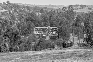 Eltham District Historical Society Inc
Photograph, George Coop, Single Motor Carriage (Red Rattler) Tait train, possibly 471M, heading for Eltham near Allendale Road, Diamond Creek, c.December 1980, 1980
... View is looking northwest from the hillside just north... melbourne View is looking northwest from the hillside just north ...View is looking northwest from the hillside just north of Allendale Road. The long rectangular house in the upper left is No. 22 Challenger Street, Diamond Creek, right at the sharp turn into Price Court. On the track in the straight section heading northwest are two small bridges where the track crosses the Diamond Creek, each fitted with derailment guard rails to prevent severe derailments should a train come off the tracks whilst crossing the culverts. Digital TIFF file Scan of 35mm Ilford FP4 black and white transparency471m, allendale road, challenger street, derailment guard rail, diamond creek, hurstbridge line, price court, red rattler, red rattler single carriage, single motor carriage, tait train -
 Melbourne Tram Museum
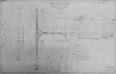
Drawing - Digtial image, Melbourne & Metropolitan Tramways Board (MMTB), "Plan and Longitudinal sections of Howard Street Siding", 2/1925
... of the Flemington Road car house near Racecourse Road North Melbourne.... of the Flemington Road car house near Racecourse Road North Melbourne ...Digital image of a drawing for the access tracks to the Howard St car house or cable tram depot from Victoria St. Shows the plan and longitudinal sections. Prepared 23/2/1925 and signed by Mr Strickland Chief Engineer on 25/2/1925. This depot was made necessary by the construction of electric tram tracks in Flemington Road in 1925 which resulted in the closure of the Flemington Road car house near Racecourse Road North Melbourne.Yields information about the access track from Victoria St to the Howard St car house. Digital image of drawing P1613, "Plan and Longitudinal sections of Howard Street Siding".m&mtb, drawings, howard st, cable trams, car houses, depots -
Glen Eira Historical Society
Letter - Howitt Road, 32, Caulfield North, Fooks House
... Howitt Road, 32, Caulfield North, Fooks House..., informing the Manager that Fooks House at 32 Howitt Road, Caulfield...32 Howitt Road, Caulfield North, Victoria, Australia... Road, Caulfield north has been classified by the National Trust ...A copy of a one page typed letter from Ian Pausacker of the National Trust of Australia (Victoria) to the Manager of the Planning Section of the City of Glen Eira, dated 08/02/2002, informing the Manager that Fooks House at 32 Howitt Road, Caulfield north has been classified by the National Trust.city of glen eira, fooks house, howitt road, caulfield north, heritage studies, the national trust of australia (victoria), historic buildings -
 Greensborough Historical Society
Photograph - Digital Image, Willis Vale site, 2014_
... in 1964 when a fire originating from North Plenty Gorge - Kurrak... originating from North Plenty Gorge - Kurrak Road - was lit by two ...Photograph of the site of the 'Willis Vale' homestead, home of the Partington family. The derelict Willis Vale house was destroyed in 1964 when a fire originating from North Plenty Gorge - Kurrak Road - was lit by two teenage boys and made its way several kilometres down to Partington's Flat Greensborough.Digital copy of colour photograph."This house is where Willis Vale homestead was on Partingtons Flat"partington family, willis vale -
 Melbourne Tram Museum
Slide, Keith Kings, 15/08/1959 12:00:00 AM
... reconstruction in Flemington Road, North Melbourne 19/12/1959, over... of track reconstruction in Flemington Road, North Melbourne 19/12 ...Colour slide, Kodak, white cardboard of track reconstruction in Flemington Road, North Melbourne 19/12/1959, over Grattan St, with trams 935 and 927 in the far distance. Note the wood block construction, the austerity bus, the hotel in the far distance on the corner of Elizabeth St and Peel St, the trees are blocking the view of the former Haymarket, the temporary track relaying and the lone watchman or "traffic controller". Slide Number K(l)(289)Extensive handwriting on rear in ink and that it was photographed at 1/60 f5.6.trams, tramways, flemington rd, grattan st, trackwork, track construction, tram 935 -
 Eltham District Historical Society Inc
Photograph - Digital Photograph, Alan King, Yarrambat Heritage Museum, 23 January 2008
... was relocated from the Golden King Mine in North Oatlands Road... was relocated from the Golden King Mine in North Oatlands Road ...Original Yarrambat Primary School building at the Yarrambat Heritage Museum, Yarrambat Park. At the museum, visitors can gain an insight into Yarrambat’s past since non-Aboriginal settlement. The museum includes the original Yarrambat Primary School, which was moved to the site in 2000 and now serves as the Yarrambat Historical Society headquarters.The museum also includes a fully operational battery (gold-bearing ore crusher) driven by a McDonald 30HP diesel engine built in Richmond in 1938. The battery was relocated from the Golden King Mine in North Oatlands Road, Yarrambat, where it operated until 1984.1 Other exhibits include farming implements and machinery from the Yarrambat district. Published: Nillumbik Now and Then / Marguerite Marshall 2008; photographs Alan King with Marguerite Marshall.; p25This collection of almost 130 photos about places and people within the Shire of Nillumbik, an urban and rural municipality in Melbourne's north, contributes to an understanding of the history of the Shire. Published in 2008 immediately prior to the Black Saturday bushfires of February 7, 2009, it documents sites that were impacted, and in some cases destroyed by the fires. It includes photographs taken especially for the publication, creating a unique time capsule representing the Shire in the early 21st century. It remains the most recent comprehenesive publication devoted to the Shire's history connecting local residents to the past. nillumbik now and then (marshall-king) collection, yarrambat heritage museum, yarrambat historical society, yarrambat primary school -
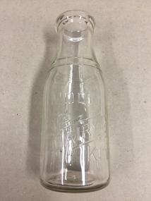 Kew Historical Society Inc
Container, Model Dairy, Milk Bottle, Twentieth Century
... depending on the time period. Its final incarnation was on the north... on the time period. Its final incarnation was on the north side ...The Model Dairy was founded by the Kew pioneer, James Venn Morgan. The dairy had a number of different locations in Kew depending on the time period. Its final incarnation was on the north side of Cotham Road, between Ridgeway Avenue and Kent Street, Kew. The final factory was designed by the architects Bates, Smart and McCutcheon.Kew was a major milk producing district in the Nineteenth and early Twentieth centuries, with three major dairy farms lining the Yarra between Studley Park in the west and Burke Road in the east. In addition to these dairy producers, there were also a number of accredited dairy retailers in the suburb. The largest and most enduring of these was the Model Dairy founded by the Kew pioneer James Venn Morgan. Milk bottles that include the name of the producer or retailer are historically significant as they represent a period in Kew's history before the mass production of milk in the second half of the Twentieth Century. A number of these named bottles have the additional attribute of rarity.Milk bottle - Model Dairy Kew. Pressed inscription: "Model Dairy Ltd Kew." Reverse: " This bottle contains milk bottled for sale by Model Dairey Ltd and always remains their property. It is loaned & cannot legally be used by others. One Imperial Pint. This bottle differs from 1981.0010 in that it has two pressed rings on the neck of the bottle.milk bottles, model dairy (kew) -
 Greensborough Historical Society
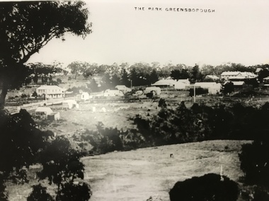
Photograph, The Park Greensborough, 1900c
... sporting ground, Plenty River, Marble Hall, sparse housing on north..., sparse housing on north side of Main Road, the Farmers' Arms ...View of Greensborough Park from Partington's Hill, showing sporting ground, Plenty River, Marble Hall, sparse housing on north side of Main Road, the Farmers' Arms hotel, the Rechabite Hall and Main Road bridge over the the railway line. Marble Hall is the double-storied building on the corner of Main Road.Part of a collection of 5 enlarged photographs dating from the early 1900s.Black and white enlargement of photographgreensborough park, main street greensborough, rechabite hall, farmers' arms hotel, marble hall, greensborough railway -
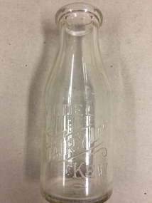 Kew Historical Society Inc
Container, Model Dairy, Milk Bottle, Twentieth Century
... depending on the time period. Its final location was on the north... on the time period. Its final location was on the north side of Cotham ...The Model Dairy was founded by the Kew pioneer, James Venn Morgan. The dairy had a number of different locations in Kew depending on the time period. Its final location was on the north side of Cotham Road, Kew between Ridgeway Avenue and Kent Street. Its final factory was designed by the architects Bates, Smart and McCutcheon.Kew was a major milk producing district in the Nineteenth and early Twentieth centuries, with three major dairy farms lining the Yarra between Studley Park in the west and Burke Road in the east. In addition to these dairy producers, there were also a number of accredited dairy retailers in the suburb. The largest and most enduring of these was the Model Dairy founded by the Kew pioneer James Venn Morgan. Milk bottles that include the name of the producer or retailer are historically significant as they represent a period in Kew's history before the mass production of milk in the second half of the Twentieth Century. A number of these named bottles have the additional attribute of rarity.Milk bottle - Model Dairy Kew. Pressed inscription: "Model Dairy Ltd Kew." Reverse: " This bottle contains milk bottled for sale by Model Dairey Ltd and always remains their property. It is loaned & cannot legally be used by others. One Imperial Pint. This bottle differs from 1981.0009 in that it does not have two pressed rings on the neck of the bottle.milk bottles, model dairy (kew) -
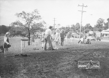 Eltham District Historical Society Inc
Photograph, ELTHAM ARBOR DAY 1973 - Alistair Knox with school children of the Shire of Eltham, Vic, planting native trees in the Town Park, 10 October 1973, 1973-10-10
... Park Looking north along Main Road; Eltham Shire Office... Park Looking north along Main Road; Eltham Shire Office ...ELTHAM - ARBOR DAY, 10 Oct 1973. School children of the Shire of Eltham planting trees (previously planned to take place during the visit of Sir Rohan Delacombe to the Shire on 19th September, 1973 but cancelled that day due to inclement weather). REF: 783 SOURCE: Shire of Eltham (Eltham District Historical Society) Eltham Town Park would later be renamed Alistair Knox Park Looking north along Main Road; Eltham Shire Office in distanceBlack and white photographeltham, arbor day, alistair knox, alistair knox park, eltham town park, main road, eltham shire office -
Glenelg Shire Council Cultural Collection
Postcard - Postcard - Percy Street Portland, Victoria, n.d
... , taken from middle of road, just north of Julia St. intersection.... looking north, taken from middle of road, just north of Julia St ...Black and white photo postcard. Percy St. looking north, taken from middle of road, just north of Julia St. intersection. Row of Norfolk pines either side of road, (unmade); man on bicycle, boy on 3 wheeler, girl standing nearby, horse and buggy; buildings ? shops behind trees. People in period dressFront: 'PERCY ST. PORTLAND LOOKING NORTH 6' - white print, bottom edge of card Back: Handwritten message on back -
Port Melbourne Historical & Preservation Society
Photograph - Woolsheds between Beacon and Barak Roads, Port Melbourne, Don Hossack, 1947
... sheds between Beacon and Barak Roads. Shows north easternmost... sheds between Beacon and Barak Roads. Shows north easternmost ...Donated by Don Hossack who took the photograph when he was 16 years old and working at the woolsheds. He recalls that bags of oats and barley were stored here.Photo (10 x 12" glossy black and white print) of the wool sheds between Beacon and Barak Roads. Shows north easternmost sheds and rail line. The wool sheds were built by the Americans during World War II and taken down again in the 1950s . Map (hand drawn) on rear shows location of photograph.map (hand drawn) of location of photographtransport - railways, built environment - industrial, war - world war ii