Showing 1814 items matching "region"
-
 Vision Australia
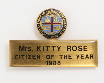
Badge - Object, Stokes, Mrs Kitty Rose Citizen of the Year 1988, 1988
Badge awarded to Senior Citizen of the Year, Mrs Kitty Rose, in recognition of her outstanding efforts for blind and vision impaired people within the Bendigo region. The top circular part of the badge has the council crest has four images which represent the shire's main industries at the time of it's establishment in 1866: wine, tanning, mining and farming.1 metal badge with circular top and rectangular baseShire of Strathfieldsaye Victorian 1866 (circular top) Mrs Kitty Rose Citizen of the Year 1988 (base)association for the blind, badges, katharine (kitty) rose -
 Vision Australia
Audio (item) - Sound recording, Royal Victorian Institute for the Blind, Around the Institute: July 17, 2001
Around the Institute was a weekly program designed to keep clients and staff informed of events, activities and thoughts relating to low vision and blindness. It consisted of interviews undertaken by Jo Matthews, with sound engineer Ed Gamble, designed to inform, educate and explore on a variety of topics. July 17: National Diabetes Week – Anne Dickinson, Western region playgroup – Amanda Perrini. royal victorian institute for the blind, radio shows -
 City of Greater Bendigo - Civic Collection
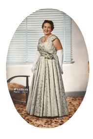
Photograph - Portrait, Martin Washington, Mrs R.H.T. Wilson Mayoress 1960 - 61
Prior to the election of female Councillors and Mayors from the 1960’s onwards the Lady Mayoress role was one of the few ways women could officially undertake civic duties. Mayoresses made important contributions to their local communities through their charity work and as ambassadors for their region on a state and federal level. They also undertook Mayoral duties on occasions if their husband was unavailable. Framed, oval photographic studio portrait. Hand coloured detail.lcl, Mrs R. H. Wilson / Mayoress 1960 - 61. lr Martin Washingtonstudio photography, martin washington, wilson, lansell pendant, city of greater bendigo portraits, city of bendigo mayoress -
 Victorian Bands' League
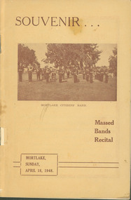
Programme, Souvenir...Mortlake Citizens' Band : Massed Bands Recital. Mortlake, April 18, 1948, 1948
This programme dates from 1948 when the Mortlake Citizens' Band held a Massed Bands Recital in Mortlake. A number of bands from the South-West region of Victoria participated with the event comprising of a March and various massed bands items. The programme is extremely detailed as to times bands were playing and also includes an amount of advertisements for local Mortlake businesses.This small programme is significant as it shows how a country town held a massed bands festival and hosted regional brass bands. It is also significant as it shows the amount of local businesses who advertised in the programme, and what kinds of businesses they were. This was obviously a major event for the town and the local band, and it appears that it was a success.Programme printed on paper with a card cover.There are some inscriptions and corrections in the programme primarily on the brief history of the Mortlake Citizens' Band.hamilton, terang, warrnabool, colac, camperdown, port fairy, mortlake, victorian bands' league -
 Falls Creek Historical Society
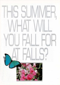
Booklet - This Summer, What Will You Fall For at Falls?
A part of a yearly marketing and information material promoting Falls Creek region for the summer holidays. The brochure outlines active and more relaxing options available at Falls Creek in the summer of 1989 - 90. Accommodation featured on the back cover includes:-Nelse Lodge, Falls Creek Motel, Viking, Lakeside LOdge, Winterhaven Lodge, Astra Lodge and Cooroona Ski Lodge.This item is important because it documents seasonal activities at Falls Creek Alpine ResortWhite A4 brochure for Summer at Falls Creek. White cover with grey title in capital letters - THIS SUMMER, WHAT WILL YOU FALL FOR AT FALLS? - with ba blue butterfly and framed image of pink flowers centred underneath. Opens to A3 size with internal double page and back page spread of images and information of Summer at Falls Creek. falls creek marketing, falls creek summer, accommodation falls creek -
 Falls Creek Historical Society
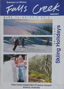
Booklet - Falls Creek Skiing Holidays 1993
Part of a yearly marketing and information material promoting Falls Creek Region. It includes accommodation rates and travel information which features a map of Falls Creek Village. Venues included in the chart are:- Astra Lodge, Diana Lodge, Karelia Lodge, Snowdrift Lodge, Snowhaven, Viking Lodge, Alpine View Apartments, Cumings Holiday Apartments and Koki Apartments.This item is important as it documents seasonal activities and accommodation venues and rates at Falls Creek Village in the 1990s. An A4 size leaflet promoting Falls Creek of the ski season of 1993. An accommodation rates chart is included in the centre page.accommodation falls creek, falls creek marketing, falls creek tourism, skiing holidays victoria -
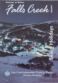
 Falls Creek Historical Society
Booklet - Falls Creek Resort Skiing Holidays 1992
This booklet is part of an annual promotional campaign for Falls Creek. It contains headings and sentences of information in Japanese, which reflects the increase in international tourism and marketing. It was designed by the Falls Creek Independent Property Owners, Victoria. The information panel on the back cover indicates it was part of Australia's Southern Region Tourism Promotion C/O Australian Tourism Commission in Tokyo, Japan.This item is important as it documents seasonal activities at Falls Creek and a changing approach to international marketing. An A4 sized marketing booklet, including images and advertising information printed on glossy paper. This publication includes headings and short lines of texts in Japanese script.falls creek marketing, falls creek information, falls creek international tourism, falls creek holiday brochures -
 Melbourne Legacy
Photograph, Junior Legatee Camp 1992, 1992
Four photos of a junior legatee camp in January 1992 at Howqua in the alpine region of Victoria. January is holiday time for Legacy's Junior Legatees. Children aged 7 to 17 join together for a 10 day action packed holiday at Camp Howqua. Legatees, members of the Melbourne Legacy Leadership Group and volunteer helpers ensure all have a memorable time.'A record of the types of experiences Legacy provided for the junior legatees.Colour photo x 4 of the Howqua camp in January 1992 and a white paper label.Label says 'January is holiday time for Legacy's Junior Legatees. Children aged 7 to 17 join together for a 10 day action packed holiday at Camp Howqua and Legacy's disabled dependants enjoy quality time at Somers Camp. Legatees, members of the Melbourne Legacy Leadership Group and volunteer helpers ensure all have a memorable time.'camp, junior legatee outing, river -
 Glen Eira Historical Society
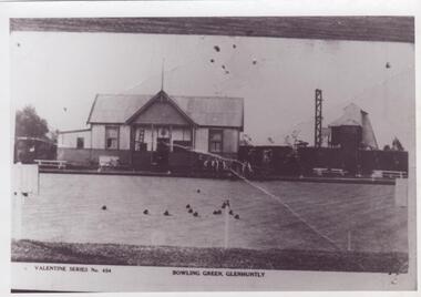
Document - Glen Huntly Bowling Club
This file contains two items about this club: 1/An eight page document named The Glen Huntly Bowling Club Jubilee Story. It is a historical account by Russell H. Keon-Cohen M.A. dated February 1964. It also describes the history of the region for fifty years. 2/Undated original black and white photograph of Glen Huntly Bowling Club.railways, caulfield, tramways, glen huntly road, glenhuntly road, grange road, mcdowing’s butcher shop, neerim road, residential development, rosstown railway, glen huntly, glen huntly hall, racecourses, pearce’s national rose gardens, bowling clubs, jones s.c., quinn mr., ellis mr., descrimes mr., kitchen cr., brookshaw cr., bowling clubs, glen huntly bowling club, ellis w., fulton t.j., lass r., newton t., pelzer p., rider h., sayer j., thomas h., boyd j.a., deans mr., gorgan thomas, woods h.s., rider mr., maxwell mr., hardnam mr., sportsgrounds, madden frank, meirest j.k., eggleston frederick, bell w., breamer b.j., carrol w., dall w.m., dunn w., mortan thomas, philips r.l., stork a.m., wells h.j., organisations, progress organisations, billiard rooms, refreshment rooms, harrison r.t.a., jones mr., glen eira mcminnon bowls club, sports, sporting clubs, jubilees, festivals and celebrations, finance, pavilions -
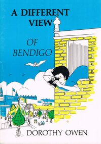 Bendigo Historical Society Inc.
Book - JOAN O'SHEA COLLECTION: A DIFFERENT VIEW OF BENDIGO POEMS, 1985
Joan O'Shea Collection. A Different View of Bendigo. Dorothy Owen. Illustrated Book of Poetry 60 Pages. Written by Local Author. Contains a map of the region of Bendigo and Surrounds along with 39 poems about Bendigo's History covering topics as diverse as How Bendigo received its name, renowned Bendigo icons such as Alexandra Fountain, The Shamrock Hotel, Hargreaves Mall, The Law Courts, Charing Cross and the Bendigo Base Hospital to Bendigo's Chinese Heritage, Gold Detecting, Highland Bands, The Dragon and Bendigo's People.Dorothy Owen Published by Bendigo Modern Press 1985bendigo, history, city history local poetry -
Tarnagulla History Archive
Newspaper clipping: Plenty Of Puff But Where's The Bell?, Plenty Of Puff But Where's The Bell?, November 22, 1988
Donald Clark Collection. Clipping from The Bendigo Advertiser, of November 22, 1988, with article titled 'Plenty Of Puff But Where's The Bell?'. Discusses train services in the region and the celebration at Tarnagulla of the centenary of the town's passenger rail link. Reports on calls to restore the passenger rail services. Also describes the centenary celebrations which involved a race between teams carrying homemade replicas of steam trains. Images of the races and one of Donald Clark. Mentions the Tarnagulla Fire Brigade Senior and Junior teams and the Tarnagulla Golf Club Juniors team all as winners. tarnagulla, railways, rail, transport, trains, steam, centenary, centenaries, commemorations, community events, fire brigade, golf club, recreation reserve, races -
City of Kingston
Photograph - Colour, c. 1993
Patterson Lakes is a suburb in the City of Kingston that is built one kilometre upstream of the mouth of the Patterson River. The area is bordered by the Patterson River and Eel Race Drain which enters the Kananook Creek. The suburb consists predominantly of newer housing developments and the tidal canal system of the development joins Port Phillip Bay.Patterson Lakes and the Kananook Creek were previously part of the extensive Carrum Carrum Swamp. The area was once a source of fish and eels for the Mayone-Bulluk clan of the Bunurong people. Over time the area was drained and in 1973 investigations commenced into the development of a unique residential area that would be built adjacent to canals and waterways. It was originally proposed to be known as "Gladesville". The development would give the suburb's homeowners access to Port Phillip Bay "from their back door". Circa 1974, the area was rezoned from rural to residential and named Patterson Lakes. Development has been continuous since the 1970s with construction of residential housing, schools, shopping centres, marinas, a hotel and library.Laminated colour aerial photograph of the Carrum and Patterson Lakes region within City of Kingston. This 1993 image includes Patterson River Secondary College, Roy Dore Reserve, Kananook Creek and Nepean Highway. The railway line can be seen as it veers inland from Eel Race Road, Seaford. The section of Palm Beach Drive, Curlew Point Drive, Snapper Point Drive, Clipper Island and Myola Street in Patterson Lakes appears to be a recent development with many spare blocks and new houses under construction.patterson lakes, seaford, kananook creek, carrum carrum swamp, canals and waterways -
City of Kingston
Photograph - Colour, 29 January 1993
Bonbeach, Carrum and Patterson Lakes are suburbs in the City of Kingston. Bonbeach and Carrum were holiday destinations in early 20th century and over time the housing has converted to permanent residential structures. In Patterson Lakes, the area consists predominantly of newer housing developments and the tidal canal system which is accessible to many dwellings joins Port Phillip Bay.Bonbeach, Carrum and Patterson Lakes were previously part of the extensive Carrum Carrum Swamp. The area was once a source of fish and eels for the Mayone-Bulluk clan of the Bunurong people. Over time the area was drained and this allowed farming at Carrum and Bonbeach, although the area was prone to flooding. In the early 1920s and 30s the land was converted to residential dwellings. In 1973 investigations commenced nearby to Bonbeach and Carrum into the development of a unique residential area comprising canals and waterways. It was originally proposed to be known as "Gladesville". Circa 1974, the area was rezoned from rural to residential and named Patterson Lakes. Development has been continuous since the 1970s with staged construction of the waterways, residential housing, and supporting infrastructure and facilities.Laminated colour aerial photograph of the Bonbeach, Carrum and Patterson Lakes region within City of Kingston. This 1993 image includes Bonbeach High School prior to demolition, Bonbeach Primary School and Patterson River Golf Club. Sections of Patterson Lakes are not yet developed, including Rhode and Staten Islands. Long Island Point appears to be a recent development with many spare blocks and new houses under construction. The Patterson River marina is prominent and the river mouth as it meets Port Phillip Bay. The Carrum railway station is visible.Black type on white adhesive sticker: No. 6661 Black type on white adhesive sticker: 26E/6661, 29/1/93, 4.25 pm Black type on white adhesive sticker 29-1-93 Yellow circular adhesive stickerbonbeach, carrum, patterson lakes, patterson river, carrum carrum swamp, canals and waterways -
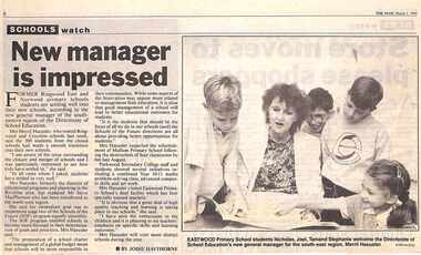 Ringwood and District Historical Society
Newspaper, Scrapbook Clipping, Library Collection, Ringwood, Victoria, `
``Newspaper clipping from "The Mail", 1-03-1994 P1. SCHOOLS watch. New Manager is impressed. By Jodie Hawthorne Former Ringwood East and Norwood primary school students are settling well into their new schools, according to the new general manager of the south eastern region of the Directorate of School Education. Mrs Merril Haeusler, who toured Ringwood and Croydon last week, said the 300 students from the closed schools had made a smooth transition into their new schools.` -
Glenelg Shire Council Cultural Collection
Functional object - Lifebuoy, n.d
City of Portland Collection|Kurtze Museum|19/4/2000. The lifebuoy came from the S S Casino. A popular cargo ship, the Casino was a regular sight on the Moyne river and along the coast. The ship was an integral part of coastal life until she was shipwrecked in the 1930's, and objects from the Casino can now be found in collections from across the region.S S CasinoCanvas covered ring of bouyant material (possibly cork), with rope loop fixed to 4 ponts on the outside edge. Inscription "S.S. CASINO" centre top, "PORT FAIRY" at centre bottom, a flag painted centre left and centre right.Front: Centre top "S. S. CASINO"|Centre bottom "PORT FAIRY"|flag on centre left and centre rightss casino, port fairy, cargo ship, lifebuoy -
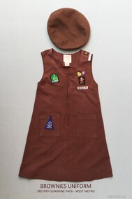 Sunshine and District Historical Society Incorporated
Brownies Uniform - 3rd North Sunshine, Early 1980's
Prior to 1996 young girls (7 - 11years) in the Girl Guide Association were known as Brownies. About circa 1983 this beret and dress were worn by a girl named Rebecca who was a member of the 3rd North Sunshine Pack - West Metro region. The 3rd North Sunshine Brownies were located in Furlong Road, North Sunshine 3020 (Melway 26 G6).This brown uniform is a historic reminder that at one stage Brownies existed as part of the Girl Guide Association.Two clothing items: (a) Beret - Brown woollen beret with a sewn on Brownies cloth badge. (b) Dress - Brown sleeveless cotton dress with 2 metal badges attached and 6 sewn on cloth badges.3rd Nth Sunshine Pack - West Metro, 19 April Action 83, Venture, Footpathbrownies uniform, 3rd north sunshine, 1983 april action, furlong road, venture, footpath, brownies beret, brownies dress -
 Kew Historical Society Inc
Photograph - Flooding of the Yarra River in North Kew, 1934
North Kew, now divided between Kew and Kew East, bordered the Yarra River. As such, it was a region subject to flooding in the Yarra Valley. Development beyond this point (ie Kellett Grove) was limited by the City of Kew's planning regulations. Prior to urban development, the area since European settlement and the first land sales in the district in the 1840s, had been used for dairy farming. Small sepia snapshot taken from the river ramp of a house at 8 Kellett Grove, in what was then known as North Kew. The point of view is from a backyard looking towards Fairfield. Beyond the fence line are two almost submerged houses. A number of people are in a motor driven boat midstream. Fairfield at this period, (ie 1934) was noted for its limited river side development. Verso: 2/12/34 / TAKEN FROM OUR RAMPyarra river -- north kew, floods -- yarra valley, floods -- north kew, floods -- 1929, floods -- 1934, natural disasters -- kew -
 Kew Historical Society Inc
Photograph - 8 Kellett Grove, North Kew, 1929
North Kew, now divided between Kew and Kew East, bordered the Yarra River. As such, it was a region subject to flooding in the Yarra Valley. Development beyond this point (ie Kellett Grove) was limited by the City of Kew's planning regulations. Prior to urban development, the area since European settlement and the first land sales in the district in the 1840s, had been used for dairy farming. Small sepia snapshot taken of the front of 8 Kellett Grove, in what was then known as North Kew. Verso: 8 KELLETT GROVE / NORTH KEW / 1929 / 418 kellett gove -- north kew, californian bungalows, houses -- kellett grove -- kew (vic.) -
 Kew Historical Society Inc
Photograph - Flooding of the Yarra River in North Kew, 1934
North Kew, now divided between Kew and Kew East, bordered the Yarra River. As such, it was a region subject to flooding in the Yarra Valley. Development beyond this point (ie Kellett Grove) was limited by the City of Kew's planning regulations. Prior to urban development, the area since European settlement and the first land sales in the district in the 1840s, had been used for dairy farming. Small sepia snapshot taken from the back yard of a house at 8 Kellett Grove, in what was then known as North Kew. The point of view is from a backyard looking towards Fairfield. Floodwaters have submerged the fence and a clothes line. Verso: BACKYARD NTH. KEWyarra river -- north kew, floods -- yarra valley, floods -- north kew, floods -- 1934, natural disasters -- kew -
 Kew Historical Society Inc
Photograph - Flooding of the Yarra River in North Kew, 1934
North Kew, now divided between Kew and Kew East, bordered the Yarra River. As such, it was a region subject to flooding in the Yarra Valley. Development beyond this point (ie Kellett Grove) was limited by the City of Kew's planning regulations. Prior to urban development, the area since European settlement and the first land sales in the district in the 1840s, had been used for dairy farming. Small sepia snapshot taken from the back yard of a house at 8 Kellett Grove, in what was then known as North Kew. The point of view is from a backyard looking towards Fairfield. Verso: 8 KELLETT GROVEyarra river -- north kew, floods -- yarra valley, floods -- north kew, floods -- 1934, natural disasters -- kew -
 Kew Historical Society Inc
Photograph - Flooding of the Yarra River in North Kew, 1934
North Kew, now divided between Kew and Kew East, bordered the Yarra River. As such, it was a region subject to flooding in the Yarra Valley. Development beyond this point (ie Kellett Grove) was limited by the City of Kew's planning regulations. Prior to urban development, the area since European settlement and the first land sales in the district in the 1840s, had been used for dairy farming. Small sepia snapshot taken from the back yard of a house at 8 Kellett Grove, in what was then known as North Kew. The point of view is from a backyard looking towards Fairfield. Verso: OUR BACKYARD 8 KELLETT GROVEyarra river -- north kew, floods -- yarra valley, floods -- north kew, floods -- 1934, natural disasters -- kew -
 Kew Historical Society Inc
Photograph - View of the Yarra River from 8 Kellett Grove, North Kew, 1948
North Kew, now divided between Kew and Kew East, bordered the Yarra River. As such, it was a region subject to flooding in the Yarra Valley. Development beyond this point (ie Kellett Grove) was limited by the City of Kew's planning regulations. Prior to urban development, the area since European settlement and the first land sales in the district in the 1840s, had been used for dairy farming. The view from the rear of 8 Kellett Grove predates the construction of the Eastern Freeway so provides a rare view of the area before it was built.Small sepia snapshot taken from the back yard of a house at 8 Kellett Grove, in what was then known as North Kew. A tower of the Kew Asylum on the top left of the horizon assist the viewer to recognise that the land to the left of the river is in Kew and Studley Park.Verso: NORTH KEW 1948 / Stamped 51019yarra river -- north kew, kellett grove -- north kew -
 Kew Historical Society Inc
Photograph - Flooding of the Yarra River in North Kew, 1934
North Kew, now divided between Kew and Kew East, bordered the Yarra River. As such, it was a region subject to flooding in the Yarra Valley. Development beyond this point (ie Kellett Grove) was limited by the City of Kew's planning regulations. Prior to urban development, the area since European settlement and the first land sales in the district in the 1840s, had been used for dairy farming. Small sepia snapshot of floodwaters taken from near Kellett Grove, in what was then known as North Kew. The point of view is from a backyard looking towards Fairfield. In the foreground ar two men in a rowboat.Verso: OUR BACKYARD / Stamped 3 163yarra river -- north kew, floods -- yarra valley, floods -- north kew, floods -- 1934, natural disasters -- kew -
 Kew Historical Society Inc
Photograph - Flooding of the Yarra River in North Kew, 1934
North Kew, now divided between Kew and Kew East, bordered the Yarra River. As such, it was a region subject to flooding in the Yarra Valley. Development beyond this point (ie Kellett Grove) was limited by the City of Kew's planning regulations. Prior to urban development, the area since European settlement and the first land sales in the district in the 1840s, had been used for dairy farming. Small sepia snapshot of floodwaters taken from near Willsmere Road, in what was then known as North Kew. The point of view is looking towards Fairfield. In the foreground are two figures viewing a group in a rowboat in the middle of the flooded river. Semi-submerged street lighting indicates that entire streets had been. overwhelmed by the flood waters. Verso: WILLSMERE ROAD NORTH KEW / Stamped 3 163yarra river -- north kew, floods -- yarra valley, floods -- north kew, floods -- 1934, natural disasters -- kew, willsmere road -
 Kew Historical Society Inc
Photograph - Flooding of the Yarra River in North Kew, 1934
North Kew, now divided between Kew and Kew East, bordered the Yarra River. As such, it was a region subject to flooding in the Yarra Valley. Development beyond this point (ie Kellett Grove) was limited by the City of Kew's planning regulations. Prior to urban development, the area since European settlement and the first land sales in the district in the 1840s, had been used for dairy farming. Small sepia snapshot of floodwaters in North Kew. The point of view is of two houses belonging to local families that were surrounded by floodwater. Verso: HYATTS HOUSE / WILLSMERE ROAD / Stamped 3 163yarra river -- north kew, floods -- yarra valley, floods -- north kew, floods -- 1934, natural disasters -- kew, willsmere road -
 Kew Historical Society Inc
Photograph - Flooding of the Yarra River in North Kew, 1934
North Kew, now divided between Kew and Kew East, bordered the Yarra River. As such, it was a region subject to flooding in the Yarra Valley. Development beyond this point (ie Kellett Grove) was limited by the City of Kew's planning regulations. Prior to urban development, the area since European settlement and the first land sales in the district in the 1840s, had been used for dairy farming. Small sepia snapshot of floodwaters in North Kew, from the rear of 8 Kellett Grove. Verso: OUR BACKYARD / Stamped 52yarra river -- north kew, floods -- yarra valley, floods -- north kew, floods -- 1934, natural disasters -- kew, willsmere road -
 Kew Historical Society Inc
Photograph - Grandfather and granddaughter in the yard of 8 Kellett Grove, Kew, 1934
North Kew, now divided between Kew and Kew East, bordered the Yarra River. As such, it was a region subject to flooding in the Yarra Valley. Development beyond this point (ie Kellett Grove) was limited by the City of Kew's planning regulations. Prior to urban development, the area since European settlement and the first land sales in the district in the 1840s, had been used for dairy farming. Vivid photograph contrasting domestic life and relationships with natural disasters such as the flood of 1934.Small sepia snapshot of a grandfather and granddaughter sitting in the backyard of 8 Kellett Grove, North Kew, with the floodwaters stretching behind them.Verso: GRANDDAD AND I IN BACKYARDyarra river -- north kew, floods -- yarra valley, floods -- north kew, floods -- 1934, natural disasters -- kew, willsmere road -
 Kew Historical Society Inc
Photograph - Submerged houses in River Avenue, North Kew, 1934
North Kew, now divided between Kew and Kew East, bordered the Yarra River. As such, it was a region subject to flooding in the Yarra Valley. Development beyond this point (ie Kellett Grove) was limited by the City of Kew's planning regulations. Prior to urban development, the area since European settlement and the first land sales in the district in the 1840s, had been used for dairy farming. Vivid photograph contrasting domestic life and relationships with natural disasters such as the flood of 1934.Small sepia snapshot of two submerged houses belonging to local families in River Avenue, North Kew, during the 1934 floods. The view is presumably from near Kellett Grove looking north towards Fairfield.Verso: COES & HYATTS ROOF / RIVER AVENUE / Stamped: 6414yarra river -- north kew, floods -- yarra valley, floods -- north kew, floods -- 1934, natural disasters -- kew -
 Kew Historical Society Inc
Photograph - Flooding of the Yarra River in North Kew, 1934
North Kew, now divided between Kew and Kew East, bordered the Yarra River. As such, it was a region subject to flooding in the Yarra Valley. Development beyond this point (ie Kellett Grove) was limited by the City of Kew's planning regulations. Prior to urban development, the area since European settlement and the first land sales in the district in the 1840s, had been used for dairy farming. Vivid photograph contrasting domestic life and relationships with natural disasters such as the flood of 1934.Small sepia snapshot of the donors grandfather rescuing the family dog's kennel from rising floodwaters at the rear of 8 Kellett Grove, North Kew, .Verso: DAD SECURING NIPPY'S DOG KENNEL / Stamped 6414yarra river -- north kew, floods -- yarra valley, floods -- north kew, floods -- 1934, natural disasters -- kew -
 Kew Historical Society Inc
Photograph - Flooding of the Yarra River in North Kew, 1934
North Kew, now divided between Kew and Kew East, bordered the Yarra River. As such, it was a region subject to flooding in the Yarra Valley. Development beyond this point (ie Kellett Grove) was limited by the City of Kew's planning regulations. Prior to urban development, the area since European settlement and the first land sales in the district in the 1840s, had been used for dairy farming. .Small sepia snapshot of a local family's house in what was then River Avenue, North Kew being surrounded by floodwaters.Verso: THE SIDE OF RYANSyarra river -- north kew, floods -- yarra valley, floods -- north kew, floods -- 1934, natural disasters -- kew