Showing 28634 items matching "street street"
-
 Kew Historical Society Inc
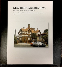
Archive (Sub-series) - Subject File, Kew Heritage Review, Residential Places Graded B, Volume 3, 1999, 1999
... 2 hodgson street..., heritage reviews - kew 4 cameron court 2 hodgson street 20 fellows ...Graeme Butler & AssociatesProject FilesProvenance OrderBlack 4-Ring binder that includes research about, and an assessment of buildings previously graded B in the City of Kew Urban Conservation Study 1988 by Pru Sanderson Design Pty Ltd. The files were created by the heritage architect Graeme Butler and the paper files include maps, correspondence, title searches, readings, reviews of prior classifications, newspaper and journal articles, directories etc for each property assessed.graeme butler, heritage reviews - kew, 4 cameron court, 2 hodgson street, 20 fellows street, 26 fellows street, 23 highbury grove, kew lunatic asylum, kew mental hospital, willsmere, 36 stawell street, 13 studley avenue, 16 studley avenue, 20 studley avenue, raheen, studley park road, beament house, 33 uvadale road, 20 yarra streetgraeme butler, heritage reviews - kew, 4 cameron court, 2 hodgson street, 20 fellows street, 26 fellows street, 23 highbury grove, kew lunatic asylum, kew mental hospital, willsmere, 36 stawell street, 13 studley avenue, 16 studley avenue, 20 studley avenue, raheen, studley park road, beament house, 33 uvadale road, 20 yarra street -
 Eltham District Historical Society Inc
Document - Property Binder, Eltham Town Square, Commercial Place, Eltham
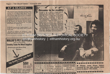
... Arthur Street... between Arthur Street and Pryor street. The plans also included... between Arthur Street and Pryor street. The plans also included ...1. Dreams to be reality, The Valley Voice, 15 August 1979, p2 - announcement of proposed town square of 1800 square metres of shop area and open courtyard to be sited in the carpark between Arthur Street and Pryor street. The plans also included tree-lined walkways from both Arthur Street and a pededstrian footbridge across Main Road leading to aregular open-air market and tavern. Shop owners facing Main Road were to be encouraged to turn their businesses towards the square. On reverse side - 'General' Marshall and his troops; Valley votes in five new faces, The Valley Voice, 15 August 1979, p1 - picture showing newly elected Cr Robert Marshall 2. Square plan on display, Diamond Valley News, Tuesday, June 23, 1981, p1 - Council's prefered proposal on display to the public. On same page a story about the son of Cr Bob Manuell being attacked on the train from the city. On reverse side - Helping people - here and abroad by Marguerite Marshall, Diamond Valley News, Tuesday, June 23, 1981, p2 - about Keith Ryall of Zig Zag Road, the Apex international councillor for Australia 3. Plan: Eltham Town Centre property Acquisition, Shire of Eltham March 1994businesses, arthur street, bible street, commercial place, dudley street, eltham, franklins supermarket, luck street, main road, map, mcewans, pryor street, safeway supermarket, apex club, bronwyn ryall, keith ryall, zig zag road, cr bob manuell, cr robert allen, det sgt noel murphy, eltham chamber of commerce, eltham police, eltham shire council, eltham town square, lorraine manuell, pauline toner mp, robert manuell, rodney roscholler, shire planner, vicrail, elections, h&j white general store, hurstbridge, leslie bowker, main street, mrs marshall, pam lawson, robert marshall, rosemary tovey, central park, comfort station, eltham little theatre, montmorency, public toilets, rotex cinema, were street -
 Ringwood and District Historical Society
Map - State Aerial Survey, Dandenong Ranges Area, Parishes of Warrandyte and Ringwood - 1956
... information. Subsequent hand-drawn addition of streets showing layout... hand-drawn addition of streets showing layout of "Township ...Map of central and southern areas of Ringwood and part of Ringwood East and Heathmont compiled by Dept of Lands and Survey, July 1956, from aerial photographs and Cadastral Survey information. Subsequent hand-drawn addition of streets showing layout of "Township of Ballyduffy Estate 1858-60", an earlier proposed subdivision that did not eventuate. (See attached 5009b Ballyshanassy_ Melbourne’s lost suburb.pdf for Ballyduffy historical naming relevance). Ballyduffy Estate streets include City Road, West Prussia Road, Duffy Street, Ireland Street, Evans Street, Victoria Street, Regina Street, Short Road, Prussia Road, Duffy Street East, Ireland Street East, Evans Street East, Chapman Street. Misc Topo 93 Sheet 22, Ringwood A4B2. Scale: 4 chains to 1 inch. Contour interval 20 feet. -
 Bendigo Historical Society Inc.
Document - MCCOLL, RANKIN AND STANISTREET COLLECTION: INDENTURE BETWEEN KING EDWARD VIII AND MONUMENT HILL CONSOLIDATED MINE, 2/09/1936
... Ophir Street... perches ) Lease site on Rowan Street, bordered by Ophir Street... Mining Company Bendigo Mine Ophir Street Rowan Street Mackenzie ...Indenture document number 10878, Vol 317 Folio 35044. Foolscap 4 pages including a map, dated 2nd September, 1936, between King Edward VIII (Crown land) and Monument Hill Consolidated (Bendigo) No Liability 'carrying on operations in the Parish of Sandhurst, to occupy and use the land demised as a site for machinery buildings and offices to be used in connexion with 'mining purposes' ' Document signed by Right Hon William Charles Arcedeckne, (Baron Huntingfield) and J. Stanistreet, Manager, affixed with the Common Seal of Monument Hill Consolidated (Bendigo) No Liability. Map drawn on dark buff paper, and fixed to document. Map shows lease 10878 in the Mining District of Bendigo, Parish of Sandhurst, County of Bendigo. N.Area 2.2.24 ( 2 acres, 2 roods, 24 perches ) Lease site on Rowan Street, bordered by Ophir Street. Coloured in purple on plan with small red area. On bottom: ' Note Red Areas Excised. Scale 4 chains to 1 inch, M.M. Var. 8 degrees 32' E. On lease site, New Chum Gully marked, W.B. House, and Permanent Occy. marked on red area. On last page ownership of lease details from 1937 to 1942.bendigo, mining, monument hill consolidated, common seal of monument hill consolidated, nell gwynne mine, south nell gwynne gold mining company, bendigo mine, ophir street, rowan street, mackenzie street.indenture vol 317 fol. 35044. j stanistreet. -
 Ringwood and District Historical Society
Map, Partially Trimmed Copy of Elphin Estate, Ringwood, Vic. - (Undated, circa 1940s)
... allotments in Heywood Street, Maidstone Street and Barkly Street... allotments in Heywood Street, Maidstone Street and Barkly Street ...Clipped subdivision map on cardboard backing.Faint handwritten sales notations on and around numbered allotments in Heywood Street, Maidstone Street and Barkly Street, Ringwood.Surrounding streets also include Lutchie Street (later Sylvia Grove) and incorrect spelling of Barkly Street as Barkley. -
 Kew Historical Society Inc
Photograph - Aerial Photograph, Aerial Photograph of Willsmere, circa 1980, c. 1980
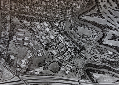
... /clergy residences on the north side of Wills Street, before... by the Boulevard, the Chandler Highway, Princess Street and Fellows Street... residences on the north side of Wills Street, before the State ...This aerial photograph shows the Kew Cottages, and doctors/clergy residences on the north side of Wills Street, before the State Government sold the land for residential development. The doctors residences in Wills street were made of 'Glen Iris' Olympic Bricks. According to neighbours of the time most of the buildings were demolished overnight in the 1980s.Aerial photograph of Willsmere and the Kew Cottages bounded by the Boulevard, the Chandler Highway, Princess Street and Fellows Street. The roundabout at the intersection of Princess Street, Wills Street, and Eglinton Street is at the top left. The Eastern Freeway is at the lower edge of the photograph.kew cottages, eastern freeway, willsmere, yarra river, aerial photographs -- kew (vic), kew boulevard, willsmere mental hospital, kew mental hospital, kew childrens cottages -
 Clunes Museum
Negative - FILM NEGATIVE
... FRASER STREET...FOUR NEGATIVES OF CLUNES STREET SCAPE FRASER STREET - TAKEN...Clunes Museum 36 Fraser Street Clunes goldfields FRASER ...FOUR NEGATIVES OF CLUNES STREET SCAPE FRASER STREET - TAKEN FROM TEMPLETON STREETfraser street, film negatives -
Bendigo Historical Society Inc.
Document - LYDIA CHANCELLOR COLLECTION: BENDIGO METHODIST CHURCH CIRCUITS PLAN OF SERVICES 1962-63, 1962-1963
... Forest Street Mackenzie Street Arnold Street Golden Square Quarry... Inc. History House 11 Mackenzie Street Bendigo goldfields ...LYDIA CHANCELLOR COLLECTION: Bendigo Methodist Church Circuits Plan of Services November, december, January 1962-63 Forest Street Mackenzie Street Arnold Street Golden Square Quarry Hillbendigo, history, bendigo churches -
 Kew Historical Society Inc
Plan - Subdivision Plan, J R Mathers & McMillan, Normanby Estate, c.1913
... weir street - kew, wharton street - kew, normanby road..., Kew East, included thirty-one lots for sale. Streets..., / 271 Collins Street / Melbourne" and Jas. R. Mathers / Estate.... weir street - kew, wharton street - kew, normanby road - kew ...The Kew Historical Society's map collection includes a substantial number of real estate subdivision plans, mainly of Kew but also of surrounding suburbs in Melbourne. Most of the subdivision plans date from the 1920s and 1930s when the districts old homes and local farmland were being split up to accommodate residential growth in the postwar period. These early plans were assembled by a local firm, Jas R Mather & McMillan, which had an office in Cotham Road. Many of the plans, and sometimes photos, were annotated by the agents.Subdivision plans are historically important documents used as evidence for the growth of suburbs in Australia. They frequently provide information about when the land was sold as well as evidence relating to surveyors and real estate and financial agents. The numerous subdivision plans in the Kew Historical Society's collection represent working documents, ranging from the initial sketches made in planning a subdivision to printed plans on which auctioneers or agents listed the prices for which individual lots were sold. In a number of cases, the reverse of a subdivision plan in the collection includes a photograph of a house that was also for sale by the agent. These photographs provide significant heritage information relating house design and decoration, fencing and household gardens.The photograph may also be aesthetically significant depending on the importance of the photographic atelier.The Normanby Estate, which was adjacent to Normanby Road, Kew East, included thirty-one lots for sale. Streets on the subdivision plan include Adeney Avenue, Park Hill Road, Normanby Road, Weir Street and Wharton Street. Cotham Road and its tramway are shown nearby. The plan is interesting as it shows Wharton Street, named after the architect and town planner George Wharton, who was the first chairman of the Municipality of Kew. The street was to later be renamed Cecil Street. Also shown are proposed ‘Municipal Gardens’ where Parkhill Drive is now located."D" in top left corner. Stamped auctioneers contact details: "Jas. R. Mathers & Son & McMillan / Auctioneer & Land Salesmen, / 271 Collins Street / Melbourne" and Jas. R. Mathers / Estate & Financial Agent / Cotham Road / Kew".weir street - kew, wharton street - kew, normanby road - kew, cotham road - kew, municipal gardens - kew, park hill parkhill road - kew, braemar - kew, subdivision plans - kew -
 Eltham District Historical Society Inc
Slide, Andrews Street, Eltham, Nov. 1981
... Andrews Street, Eltham...private street scheme.... 1981) of the Beard street group, a private street scheme.... 1981) of the Beard street group, a private street scheme ...Roll of film taken by Eltham Shire Council officers (Nov. 1981) of the Beard street group, a private street scheme, before construction commenced in February 1982. They provide perspective of the changes in housing styles and road development that began sweeping in from the mid 1970s with increasing urbanisation of what was once more outlying suburbs and regions.35 mm colour positive transparency (1 of 27) Mount - Kodak Ektachrome CardProcessed 18 Jan 1982roads, housing estate, infrastructure, private street scheme, andrews street -
 Eltham District Historical Society Inc
Slide, Beard Street, Eltham, Nov. 1981
... Beard Street, Eltham...private street scheme.... 1981) of the Beard street group, a private street scheme.... 1981) of the Beard street group, a private street scheme ...Roll of film taken by Eltham Shire Council officers (Nov. 1981) of the Beard street group, a private street scheme, before construction commenced in February 1982. They provide perspective of the changes in housing styles and road development that began sweeping in from the mid 1970s with increasing urbanisation of what was once more outlying suburbs and regions.35 mm colour positive transparency (1 of 27) Mount - Kodak Ektachrome CardProcessed 18 Jan 1982roads, housing estate, infrastructure, private street scheme, beard street, eurabbie court -
 Bendigo Historical Society Inc.
Document - MCCOLL, RANKIN AND STANISTREET COLLECTION: INDENTURE GOLD MINING LEASE CROWN LAND 11197 ALICE PEEL, 8th July 1945
... . Streets: Gladstone Street, Adam Street, Houston Street, Fletcher... Edward Pell Gladson Adam Huston Fletcher and Honeybone Streets. 6 ...6 page indenture document plus plan, between King George VI and Alice Peel Executrix of the Will of Edward Peel, deceased., dated 8th July, 1945. Lease number 11197, total area of 11 acres, 3 roods, 15 perches. Leases shown on plan: 1197, 1198, 11062, 10690, 11141, 11075. Cemetery reserve shown. Streets: Gladstone Street, Adam Street, Houston Street, Fletcher Street, Honeybone Street, Key on plan shows depths correlated to colours. On back of document history of ownership of lease shown - Deborah Gold Mines No Liability, dated 1946, and 1950.bendigo, mining, lease 11197 bendigo. edward peel, alice peel, edward pell, gladson, adam, huston fletcher and honeybone streets. -
![Newspaper Clipping - Digital Image, Street poll on streets 1974 [Greenhills], 24/09/1974](/media/collectors/4f729f5697f83e03086015b8/items/5eb52fca21ea671f18ffc9aa/item-media/5eb5300621ea671f18001764/item-fit-380x285.jpg) Greensborough Historical Society
Greensborough Historical SocietyNewspaper Clipping - Digital Image, Street poll on streets 1974 [Greenhills], 24/09/1974
... Street poll on streets 1974 [Greenhills]...street construction... Council, regarding street construction in Greenhills. Streets... by Diamond Valley Council, regarding street construction ...Results of a poll conducted in 1974 by Diamond Valley Council, regarding street construction in Greenhills. Streets include: Albion Crescent, Bruce Street, Carnon Street, Cairns Street, Crest Street, Mine Street, Pembroke Street, Hope Street, Forrest Street and Hebden Street.Concerns over street construction as Greensborough moves from a semi rural to suburban area.News clipping, black and white text.shire of diamond valley, greenhills, street construction, albion crescent greensborough, carnon street greenhills -
 Port Melbourne Historical & Preservation Society
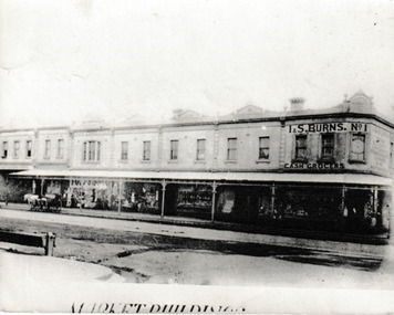
Photograph, Market Buildings, c.1915
... The group of buildings running down Bay Street from Liardet...Photograph of the Market Buildings in Bay Street running...On reverse 'Market Buildings PM L Cou..... Bay Street Cr... Melbourne Town Hall 333 Bay Street Port Melbourne melbourne ...The group of buildings running down Bay Street from Liardet Street were know as the Market Buildings. On the corner was I & S BURNS No 1 Cash Grocer. Part of this site is currently occupied by Coles Port Melbourne supermarket.Photograph of the Market Buildings in Bay Street running down from Liardet Street. At the top of the corner building it reads I & S Burns No 1 Cash Grocers.On reverse 'Market Buildings PM L Cou..... Bay Street Cr Liardett Street'market buildings, built environment - commercial, business and traders - grocers and supermarkets, coles supermarket, i & s burns no 1 cash grocer, i & s burns -
Bendigo Historical Society Inc.
Document - LYDIA CHANCELLOR COLLECTION: BENDIGO METHODIST CHURCH CIRCUITS PLAN OF SERVICES 1964, 1964
... for the following churches: Wesley (Forest Street) Mackenzie Street Arnold... Inc. History House 11 Mackenzie Street Bendigo goldfields ...LYDIA CHANCELLOR COLLECTION: Bendigo Methodist Church Circuits Plan of Services February, March, April 1964 for the following churches: Wesley (Forest Street) Mackenzie Street Arnold Street Golden Square Quarry Hillbendigo, history, bendigo churches -
Port Melbourne Historical & Preservation Society
Photograph - Various streets in Port Melbourne, Ron Laing, 1990 - 1999
... A set of 49 colour photographs of varous streets in Port... Melbourne Town Hall 333 Bay Street Port Melbourne melbourne Part ...Part of Ron LAING's collection of photographs recording Port Melbourne over a thirteen year period. Donated to the PMH&PS by the photographer.A set of 49 colour photographs of varous streets in Port Melbourne, including Graham Street, Swallow Street (before and after wrecking), Bain Street, Graham overpass, Williamstown Road, Normanby Road, Ross Street and Bay Street, Princes Street March 1999 (Number 48 missing August 2015)built environment, ron laing -
 Ringwood and District Historical Society
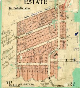
Map, Subdivision Plan, Loughnans Road, Ringwood - circa 1922
... Road, William Street, Andrew Street, Harrison Street, and Munro..., 352 Collins Street, Melbourne...., 352 Collins Street, Melbourne. Green card with cut-out map ...Green card with cut-out map of residential allotments, some marked "sold". "Plan of Estate" includes Wonga Road, Loughnans Road, William Street, Andrew Street, Harrison Street, and Munro Street, Ringwood. (Surrounding area is part of Ringwood Park Estate featured in seperate 1922 auction flyer).Handwritten notations - (northern section) {£2-10/- per foot. £5 deposit bal £1 per month} All the rest £2 per foot, value same as above. Licensed Surveyors - W.J. & A.W. Kenhardt, 352 Collins Street, Melbourne. -
 Kew Historical Society Inc
Plan - Subdivision Plan, J R Mathers & McMillan, Plan of Subdivision of Part of Crown Portion 83 at Kew : LP6669, 1923-1939
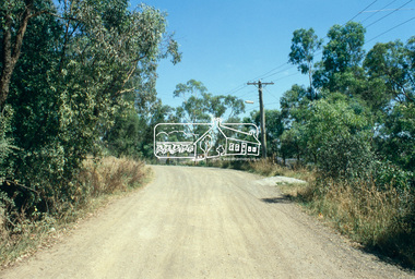
... parkhill road - kew, cecil street - kew, normanby road... Avenue and Normanby Road there was only one street running..., Normanby Road, and an unnamed street [now Cecil Street] in Kew.... and Normanby Road there was only one street running between Park Hill ...In 1888, in the section of Park Hill Road between Belmont Avenue and Normanby Road there was only one street running between Park Hill Road and Cotham Road. This was Park Road, later to be named Adeney Avenue. Subsequent 20th century subdivisions created the ‘through roads’ of Cecil Street, Wimba Avenue, Florence Avenue, Marshall Avenue, Uvadale Road, and Barrington Avenue. This subdivision represents an attempt by auctioneers, rather than town planners to create an urban environment from larger residential allotments or in many cases farmland. Existing streets such as Parkhill and Normanby Roads provided a convenient starting point for the surveyors, but the Road named ‘Street Street’ indicates the role of the private surveyor in creating streets. Given that a number of allotments are listed as sold on the plan, the street is presumably Cecil Street. Even those lots that had been sold do not quite match the dimensions of the blocks in this parcel of land today, indicating that either further subdivisions or boundary alterations occurred.Subdivision plans are historically important documents used as evidence for the growth of suburbs in Australia. They frequently provide information about when the land was sold as well as evidence relating to surveyors and real estate and financial agents. The numerous subdivision plans in the Kew Historical Society's collection represent working documents, ranging from the initial sketches made in planning a subdivision to printed plans on which auctioneers or agents listed the prices for which individual lots were sold. In a number of cases, the reverse of a subdivision plan in the collection includes a photograph of a house that was also for sale by the agent. These photographs provide significant heritage information relating house design and decoration, fencing and household gardens.The photograph may also be aesthetically significant depending on the importance of the photographic atelier.Hand-drawn subdivision plan of 19 lots facing Parkhill Road, Normanby Road, and an unnamed street [now Cecil Street] in Kew.Estate Agent notes in ink indicate those lots which had sold.subdivision plans - kew, parkhill road - kew, cecil street - kew, normanby road - kew, cecil street -kew, parkhill road - kew, normanby road - kew, crown portion 83 - kew -
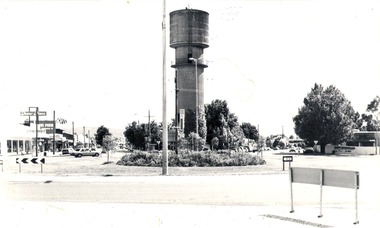 Wodonga & District Historical Society Inc
Photograph - Codling Collection 01 - Water Tower, High Street, 1980
... Codling Collection 01 - Water Tower, High Street...Codling Collection 01 - Water Tower, High Street...Hovell Street Wodonga...THE WATER TOWER is a major landmark of High Street, Wodonga... businesses High St Wodonga Water Tower Hovell Street Wodonga High ...Miss Olive Codling was a Foundation Member and a Life Member of the Wodonga Historical Society. Many of her prize-winning photos are held in the Society Collection. She also held a range of roles and committee positions in a wide range of Wodonga community organisations. These included the Horticultural Society, the Wodonga Arts Council, the Wodonga Camera Club and the Wodonga Lapidary Club. Elaine Mann was married to David Mann, a successful Wodonga businessman and community leader who passed away in Wodonga in June 2012. David was a member of the Mann family who began their business in Wodonga in 1920. Elaine was a teacher in Wodonga for many years.This photo collection is significant as it documents how the businesses and buildings in Wodonga have evolved and contributed to community throughout the 20th century.THE WATER TOWER is a major landmark of High Street, Wodonga. It began operation from January 1924 until it ceased operation in 1959. It stood unused for a decade until the lower section was modified and put to use as “ The Tower’s Cobbler’s Inn” in 1962. In 1972 Wodonga City Council proposed to demolish the Tower. Their suggestion received an unfavorable response from the city’s citizens, so the Tower still stands today. This image shows High Street and Hovell Street looking to the north The Civic Centre Theatre is on the right in Hovell Street. On the left in High Street is Tower Place on left. On the far left Repco which by 1998 became a Chinese restaurant and remains so in 2021.wodonga businesses, high st wodonga, water tower, hovell street wodonga, high street wodonga -
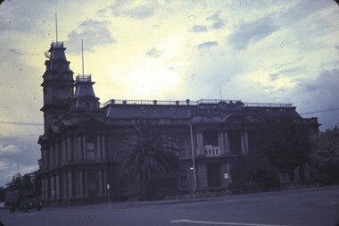 Bendigo Historical Society Inc.
Slide - BENDIGO & EASTER FAIR, 1963
... Bendigo Town Hall. View from Hargreaves Street, Williamson... Inc. History House 11 Mackenzie Street Bendigo goldfields ...Bendigo Town Hall. View from Hargreaves Street, Williamson Street side.slide, bendigo, bendigo town hall -
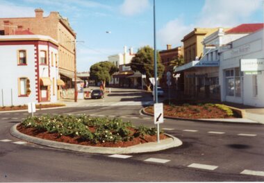 Stawell Historical Society Inc
Photograph, Gold Reef Mall -- Main Street Stawell 2003
... Gold Reef Mall -- Main Street Stawell 2003...Gold Reef Mall Main Street 2003...Colour Photograph: Looking West showing the Main Street... grampians Gold Reef Mall Main Street 2003 stawell business Colour ...Gold Reef Mall Main Street 2003Colour Photograph: Looking West showing the Main Street / Patrick Street intersection.stawell business -
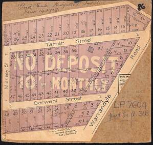 Ringwood and District Historical Society
Map, The Ringwood Estate - Second Sub-Division, Ringwood, Victoria - 1919
... Street, Mersey Street and Derwent Street....H.C. Crouch BCE, Licensed Surveyor, 443 LtCollins Street...H.C. Crouch BCE, Licensed Surveyor, 443 LtCollins Street ...Three cardboard-backed copies of map clipped from land sale auction brochure. Subdivision includes Warrandyte Road, Tamar Street, Mersey Street and Derwent Street.H.C. Crouch BCE, Licensed Surveyor, 443 LtCollins Street, Melbourne. Handwritten real estate notations in margins and on some allotments include sales information and reference LP7604 - Part of Crown Allotment 31B. Auction date June 14th, 1919. -
 Ringwood and District Historical Society
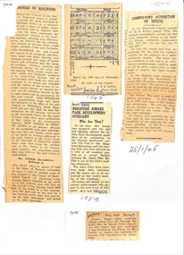
Newspaper, Newspaper articles detailing the acquisition of 40 acres of land for Jubilee Park, formerly known as Sanders Estate, for recreation purposes
... . The area included named streets - Prussia Road (not West Prussia..., for recreation purposes in 1945-1959. The area included named streets ...Various newspaper articles about detals of the acquisition, by Ringwood Council, of 40 acres of land for Jubilee Park, formerly known as Sanders Estate, for recreation purposes in 1945-1959. The area included named streets - Prussia Road (not West Prussia Road), Duffy Street, Ireland Street, Evens Street and Chapman Street. -
 Melbourne Tram Museum
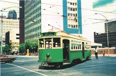
Postcard - Tram Y 469 - Latrobe St 1985, Association of Railway Enthusiasts (ARE), 2006
... William Street... Street into La Trobe Street during the 1985 cable car... Postcard featuring Y class tram 469 turning from William Street ...Postcard featuring Y class tram 469 turning from William Street into La Trobe Street during the 1985 cable car celebrations. Tram showing destination of Football. Flagstaff station was under construction at the time. Photo by Earl Ewers. Postcard produced by Association of Railway Enthusiasts ARE No. 10/06. Has Railcard copyright and phone number of rear, ARE shop details and hours, space for small message, address and stamp. This tram is on display at the Museum's Hawthorn Depot - see reference.Yields information about Y class trams and the intersection of William and Latrobe Streets.Postcard - Tram Y 469 - La Trobe St 1985 - produced by the Association of Railway Enthusiasts.trams, tramcars, y class tram, tram 469, william street, la trobe street, are -
 The Beechworth Burke Museum
Photograph, Saunders, Unknown
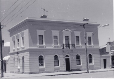
... ford street... of Ford and Camp streets and embodied the dignified appearance...The Beechworth Burke Museum Loch Street Beechworth high ...The photograph depicts the two-storey building of the Bank of Victoria which was built in 1858 and was replaced in 1867 after a fire destroyed the original building. The branch had originally opened under John Farran in 1856 before the office building was erected in Beechworth. The building was located on the corner of Ford and Camp streets and embodied the dignified appearance of Beechworth during the mid-1800s due to the building's features. The Bank of Victoria was designed by "Smith and Watts" and built from white brick and render, which cost three thousand and seven hundred pounds to construct. The building was inspired by a formal Italian villa, including square-headed windows, cornices, and a parapet. The ground floor consisted of banking chambers, a strong room, and servants' quarters. The residential quarters were located on the second floor.The photograph is significant as it depicts not only depicts a building of importance to the town of Beechworth but it also shows aesthetic significance due to the style it was built in. As the Bank of Victoria was constructed in the classic Italian style, it exemplifies the classic quality and refined manner of this architectural style. This building style represents the image Beechworth held for itself at that time, which was a sophisticated and distinguished town.Black and white rectangular photograph printed on paper.Reverse: 23/80 / Beechworth / (Indecipherable) / Banking to (Indecipherable) / Sydney / “Bank of Victoria” / BMM 8692.1 / [Stamped: ILFORD]bank of victoria, beechworth, banks, beechworth bank, 1858, 1867, ford street, camp street, victoria, john farran, smith and watts, italian architecture, italian style building, brick building, brick, banking, money, fire, building destroyed -
 The Beechworth Burke Museum
Photograph
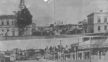
... camp street... photograph was taken of Camp Street, Beechworth, looking south...Obverse: Camp Street looking South / Ford Street looking...The Beechworth Burke Museum Loch Street Beechworth high ...This item has two photographs split horizontally. The top photograph was taken of Camp Street, Beechworth, looking south and the bottom image was taken of Ford Street, Beechworth, looking east.Black and white photograph printed on matte photographic paper. Obverse: Camp Street looking South / Ford Street looking East / Reverse: 1997.3095 / AO3192 / PH 77 / post 1906. / GH. Farley listed 1917-1918. / around 1910. See Camp St. Photo of Coronation arch Showing street lamp beechworth, camp street, ford street, burke museum