Showing 1857 items matching "subdivisions"
-
 City of Kingston
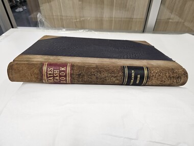
Book - Rates Cash Book, Rates Cash Book Moorabbin Shire, c.1918
Councils use property values to calculate how much each property owner pays in rates. This can give us some insight to property values within the municipalities. Receipts have been recorded by Receipt No, Date, Name and Riding. The subdivisions at that time which which were proclaimed by Order-in-Council on 22nd May 1917, were North Riding, Moorabbin Riding, Cheltenham Riding, and South Riding.Brown suede and Black linen bound book with Rates Cash Book Moorabbin Shire in gold text along the spinePrinted on white rectangular sticker in black ink: ARNALL & JACKSON/ Engravers and Lithographers/ PRINTERS/ and/ MANUFACTURING STATIONERS/ 478 Collins Street/ MELBOURNE/ No.B 33325 / 2/10/18 rates, ridings, moorabbin, municipality -
 Ringwood and District Historical Society
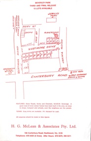
Flyer, Land Sale Advertisement, Beverley Park, Heathmont - circa late 1970s
Single sided leaflet with red printSubdivision includes Wantirna Road, Daisy Street, Vale Street, Westmore Drive, Jarma Road, Canterbury Road. Sole Agents - H.G. McLean & Associates Pty. Ltd. 166 Canterbury Rioad, Heathmont, Vic. 3135 Telephone 870 3422 (3 lines) After Hours 870 5879, 288 5071 -
 Ringwood and District Historical Society
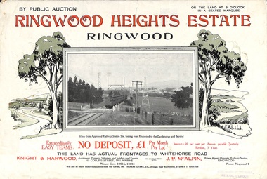
Flyer, Subdivision Advertisement - Ringwood Heights Estate Public Auction - March, 1924
Refer also to Reg. No. 5185 for Ringwood Heights Estate final section release (August 1924)Folded double-sided brochure advertising Ringwood Heights Estate Public Auction on Saturday March 1, 1924, with town photographs, location map, terms of sale, and summary of local features and services.Subdivision includes Whitehorse Road, Bon View Avenue, Grant Crescent, Hillcrest Avenue, Heatherbrae Avenue, Margaret Street, and Mary Street. (Agents) Knight & Harwood, 315 Collins Street, Melbourne, Phones Central 10615, 10616, in conjunction with J.B. McAlpin, Opposite Railway Station, Ringwood, Phone Ringwood 7. -
 Surrey Hills Historical Society Collection
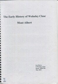
Book, The early history of Wolseley Close, Mont Albert, 2010
Includes copy of will of William Clark. Resident of the property at 9 Wolseley Close in 1910. Includes copy of the Alan Holts home occupier / tenant records - names from 1920 - 1980. Includes photo of Wolseley Close house, taken 1888/1889 plus colour photo of Wolseley Close house taken by Lin Merry, 2010. Land Title information, surveys, subdivision Includes list of occupants of the house, p.17Includes some plans of houses built in Wolseley Close, Mont Albert, Victoria. Outlines details of property at 9 Wolseley Close19p : col illcragg family, windsor crescent, surrey hills, (mr) william ainger, (mr) isaiah ainger, whitehorse road, noorn hill, house names, koonda, d j maloney, (mrs) louisa clara maggs, taramera, union road, st.abbs, york street, (mr) william henry cleverdon, wolseley street, windsor park estate, tarawera, merry family, clinton family, adams family, tel-el-kebir, farrell family, (mr) william clark, trafalgar street, (mr) (sir) matthew davies, (mr) c h james, (mr) james munro, (mrs) elizabeth clark, langdale, (mr) stanley dewar, (mr) john jose, (mrs) emily hampton, potton, (mr) alexander potton, (mr) john atkinson morris, freehold investment & banking co., mont albert, windsor park surrey hills, dalton family, (mr) henry wood, wolseley close -
 Greensborough Historical Society
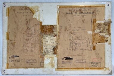
Poster - Planning Document, City of Heidelberg et al, Subdivision Plan # 5 - Crown Portion 17, Parish of Nillumbik, and Crown Portion18, Parish of Keelbundoora, 1925-1972
Subdivision Plan # 5 - Side 1: Crown portion [unknown - damaged], Parish of Nillumbik, Springfield Street, Turner Street Briar Hill,1963 amended 1972 and Crown Portion17, Parish of Keelbundoora: Thoona Grove, Donald Street. Paterson Crescent Greensborough, 1963 amended 1967. Side 2: Parish of Keelbundoora, Crown Portion 18: Boyd Street, Kempston Street Greensborough 1925; and Main Street Greensborough. An example of hard copy subdivision plans from the Greensborough area. Mainly from the Shire of Diamond Valley era (1964-1994).Plan (2 sided) mounted on heavy card. Stamped and handwritten Council permissions, dates and other details.subdivision plans, city of heidelberg, greensborough, briar hill, main street greensborough -
 Warrnambool and District Historical Society Inc.
Book, Road register loose binder, 1953
This is an Alphabetical Register of the streets in Warrnambool as listed by Warrnambool City Council officers. It appears to have been a working register used in the 1950s, 60s and 70s and information has been added to the entries as it became available and as Council works were carried out in these streets. It contains information on the locality, wards, allotment numbers, lodged plan numbers, footpaths and printed information from the Victorian Local Government Departments. It sometimes gives the origin of the name of the street and some other miscellaneous information is included. It is presumed that the information contained therein has now been stored electronically. This is a most important ledger as it contains much valuable historical information on Warrnambool streets. It will be of great use to researchers. This is a loose leaf binder with a black leather cover and a black metal and cord binding mechanism. The pages are unnumbered but there is provision for insertion or removal of pages and there are leather alphabetical tabs protruding from the pages. The pages have blue ruled lines with blue lined margins and headings. The streets in Warrnambool are listed alphabetically and the information in the register contains both typed and handwritten material. There are also printed notices from the Victorian Local Government department, extracts from newspapers, copies of letters and plans of street subdivisions. There is one loose page.warrnambool city council, warrnmbool streets register -
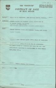
 Bendigo Historical Society Inc.
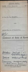
Document - H.A. & S.R. WILKINSON COLLECTION: CONDITION OF SALE
Contract of sale of land dated 29th January 1954 between Mr. E.M. Hopper (seller) and Mr. G.J. O'Donnell (buyer) for land being Lot 2 on plan of subdivision No. 23332 registered in the office of titles, Melbourne and situate in Lindsay Street Kangaroo Flat part of Crown allotment 11 section 23, township of Kangaroo Falt described in Certificate of title volume 7446 folio 423, together with weatherboard dwelling, wood shed-lavatory also fencing on the said land. Price 2,700 pounds.organization, business, h.a. & s.r wilkinson real estate -
 Bendigo Historical Society Inc.
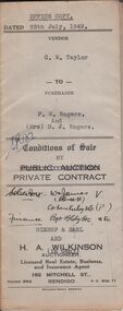
Document - H.A & S.R. WILKINSON COLLECTION: CONDITION OF SALE
Conditions of sale by private contract issued by Bishop & Earl and H.A. Wilkinson and dated 25th July, 1949 between C.M. Taylor(seller) and F.W. Rogers + D.J. Rogers (buyers) land situate No. 47 Reginald Street Bendigo at present occupied by the purchaser as tenant, being part of Crown allotment 23 section 104C described in Crown grant volume 2052 folio 410334 as per plan of subdivision approved by the Bendigo Council, together with 4-roomed weatherboard dwelling and all sundry. Price 1,100 poundsorganization, business, h.a. & s.r wilkinson real estate -
 Bendigo Historical Society Inc.
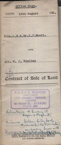
Document - H.A. & S.R. WILKINSON COLLECTION: CONDITION OF SALE
Contract of sale of land issued by H.A. Wilkinson and dated 15th August, 1952 between Mrs. L.M. & Mr. K. J. Monti (sellers) and Mr. W.J. Rielley for land being Lot 3 on plan of subdivision lodged in the office of titles in red ink No. 5062838 and being part of Crown allotment 20A section 16, City of Bendigo, Parish of Sandhurst, County of Bendigo and situate in Napoleon Crescent, White Hills, together with 6-roomed weatherboard dwelling and all sundry. Price 2,850 pounds.organization, business, h.a. & s.r wilkinson real estate -
 Bendigo Historical Society Inc.
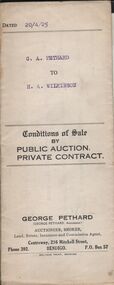
Document - H.A. & S.R. WILKINSON COLLECTION: CONDITION OF SALE
Conditions of sale by private contract dated 20th April 1925 between G. A. Pethard as seller and H. A. Wilkinson as buyer. Contract issued by George Pethard Auctioneer for sale of land situate in Elizabeth Street Nyah West being lot 100 on plan of subdivision No. 6415 lodged in the office of titles and being part of Crown Allotment 11 Parish of TynTynder West County of Tatchera described in certificate of title volume 4642 Folio 928297, together with 4-roomed weatherboard dwelling. Price 518 pounds.organization, business, h.a. & s.r wilkinson real estate -
 Bendigo Historical Society Inc.
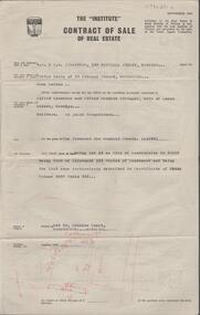
Document - H. A. & S. R. WILKINSON COLLECTION: CONTRACT OF SALE
Contract of sale of real estate dated 15th April, 1965 between Mrs. E. Keily (vendor) and Mr. A. L. & Mrs. A. K. Stringer (purchaser). Solicitor for vendor: Mr. H. E. Every, Dispensary Walk, Bendigo. Solicitor for purchaser: Messrs. Watson, James & Rogers, View Point, Bendigo. Property lot 18 Collins Court, Kennington being lot 18 on plan of subdivision no. 25138 being part of allotment 129 described in certificate of title volume 8297, folio 335. Price 1,200 pounds.organization, business, h.a. & s.r wilkinson real estate -
 Bendigo Historical Society Inc.
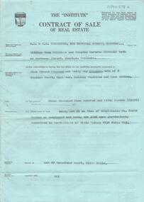
Document - H. A. & S. R. WILKINSON COLLECTION: CONTRACT OF SALE
Contract of sale dated 16th July 1964 between Mr. W. B. & W. B. Nicholls (vendor) and Mr. A. E. & Mrs B. Stephens (purchaser). Solicitor for vendor: Messrs. Macaboy, Taylor & Taylor, Hargreaves Street, Bendigo. Solicitor for purchaser: Mr. H. E. & Mrs. B. M. Stephens. Lot 29 Morsehead Court, White Hills being lot 29 on plan of subdivision No. 60209 land described in certificate of title volumr 8434 folio 603. Price 3950 pounds.organization, business, h.a. & s.r wilkinson real estate -
 Bendigo Historical Society Inc.
Document - H. A. & S. R. WILKINSON COLLECTION: CONTRACT OF SALE
Contract of sale of real estate dated 8th November, 1963 between Mr. R. P. & Mrs. M. O. Miller (vendor) and Mr. E. C. Spence (purchaser). Solicitor for vendor: Watson, James & Rogers, Bull Street, Bendigo. Solicitor for purchaser: Watson, James & Rogers, Bull Street, Bendigo. Property: Sterry Street, West Bendigo being lot 3 on plan of subdivision No. 52992 land described in certificate of title volume 8399 folio 464. Price: 400 pounds.organization, business, h.a. & s.r wilkinson real estate -
 Kew Historical Society Inc
Book, Plan of General Development, Melbourne : Report of the Metropolitan Town Planning Commission
The 1929 report of the Metropolitan Town Planning Commission covering Melbourne and its suburbs. Includes photographs and 15 folding maps (some in rear pocket) This was a planning scheme to prevent 'misuse' of land and protect property values. It highlighted traffic congestion, the distribution of recreational open space and haphazard intermingling of land uses. The plan identified a number of problems, such as the congestion at St Kilda Junction, that were not addressed until decades later. The plan also recognised the value of Melbourne's waterways as an open space network.xii, 308 p., [25] leaves of plates (24 folded) : ill., maps (some col.), ports., plans ; 34 cm. CONTENTS Part 1 Surveys and studies Part II Communications Part III The execution of improvement schemes - a programme of urgent works Part IV Zoning Part V Public Recreation Part VI Public Utilities Part VII Housing and Land Subdivision Part VIII Civic Art and Amenities Part IX Miscellaneous Part X Legislation Part XI Conclusionnon-fictionThe 1929 report of the Metropolitan Town Planning Commission covering Melbourne and its suburbs. Includes photographs and 15 folding maps (some in rear pocket) This was a planning scheme to prevent 'misuse' of land and protect property values. It highlighted traffic congestion, the distribution of recreational open space and haphazard intermingling of land uses. The plan identified a number of problems, such as the congestion at St Kilda Junction, that were not addressed until decades later. The plan also recognised the value of Melbourne's waterways as an open space network.city planning -- victoria. -- maps, city planning -- victoria -- melbourne, city planning -- victoria, civic improvement -- victoria -- melbourne, melbourne -- (vic.), cartography -
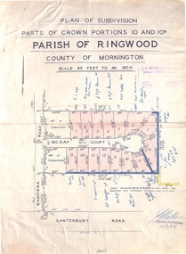 Ringwood and District Historical Society
Map - Plan of Subdivision, Parts of Crown Portions 10 and 10B Parish of Ringwood - 1958
Folded subdivision map of 15 residential allotments in McKay Court Ringwood, off Wantirna Road north of Canterbury Road. Rubber stamped by Surveyors and Chartered Engineers J.S. Watson & Associates, Mornington and South Yarra, with illegible signature dated 17/2/58. Handwritten notations indicating allotment sale names and amounts or where passed in. Accompanying clipping on scrap paper backing from Land Sale Brochure with description of available services and local facilities and terms of sale - £75 Deposit £10 Monthly. -
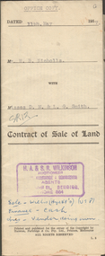 Bendigo Historical Society Inc.
Document - H.A. & S.R. WILKINSON COLLECTION: CONTRACT OF SALE
This business was owned by father and son, Henry Archibald Wilkinson and Samuel Ronald "Ron" Wilkinson. Henry (1882-1954) was born in Shepparton and died in Bendigo. He was married to Grace Hovendon in 1908. Samuel Ronald "Ron" (1914-1995), Henry's son, was married to Florence Jean McKerlie in 1937.Contract of sale of land dated 11th May, 1957 between Mr. W.B. Nicholls (seller) and Misses D.M. & L.G. Smith. For land being lot 8 on vendor's plan of subdivision by Mr. Surveyor Pritchard, dated 2nd May, 1957 having a frontage of 59 feet to Alamein Court by a depth of 100 feet, being part allotment 7 section 31A land described in Crown grant volume 8113 folio 731. Subject to any registered appurtenant easements. Price 3,600 pounds.organization, business, h.a. & s.r wilkinson real estate -
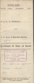 Bendigo Historical Society Inc.
Document - H.A. & S.R. WILKINSON COLLECTION: CONTRACT OF SALE
This business was owned by father and son, Henry Archibald Wilkinson and Samuel Ronald "Ron" Wilkinson. Henry (1882-1954) was born in Shepparton and died in Bendigo. He was married to Grace Hovendon in 1908. Samuel Ronald "Ron" (1914-1995), Henry's son, was married to Florence Jean McKerlie in 1937.Contract of sale of land dated 22nd November, 1956 between Mr. W.N. Nicholls (seller) and Mr. G.A. & Mrs. M.L. Quirk (buyers) for piece of land being lot 17 of plan of subdivision No. 33303 lodged in the office of titles being part of Crown allotment 16 section 7A, Kangaroo Flat and situate corner Camp and carpenter Streets, Kangaroo Flat, together with brick veneer dwelling and all sundry, also all electric light fittings and shades. Price 4,500 pounds.organization, business, h.a. & s.r wilkinson real estate -
 Ringwood and District Historical Society
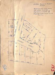
Document - Folder, Commercial and Retail Property Sales Information, Civic Place and Melbourne Street, Ringwood - 1998
45 photocopied pages including - Plan of Subdivision No.LP80718, Parish of Ringwood, Victoria, Crown Portion 12(Part) and part of a former government road Ref Vol 8668 Fol 745. - Vendors Statement, Planning Certificate and Heritage Council (Victoria) Certificate issued for 20 Melbourne Street, Ringwood. - Maroondah City Council Land Information Certificate for 149 149A and 149B Maroondah Highway; number 8 Civic Mall; and numbers 16, 20, 22 & 24 Melbourne Street Mall. - Yarra Valley Water statements relating to encumbrances for Shop 11, 149 Maroondah Highway; Shop 10, 149A Maroondah Highway; Shop 9, 149B Maroondah Highway; numer 8 Civic Place; Unit 3, 20 Melbourne Street; Office 4, 20 Melbourne Street; Shop 7, 22 Melbourne Street; and Shop 8, 24 Melbourne Street. - Land Tax Certificate pertaining to Commonwealth Bank, Civic Place, Ringwood. - Certificate of Title Vol 8892 Fol 906, Lot One on Plan of Subdivision No. 80718, Parish of Ringwood - Hanover Developments P/L - 29th June, 1971. -
 Eltham District Historical Society Inc
Photograph - Colour Print, Belle Vue, Livingstone Road, Eltham, c.2015
Belle Vue property in Livingstone Road, Eltham was once owned by Society member Jo McCormick. Jo was a valued member of our committee and dear friend of many of our members until her death in 2009. Belle Vue is the farmhouse of a property that is now a significant part of suburban Eltham, just a short distance north of the town centre. Originally purchased by pioneer Eltham farmer Henry Stooke, the present-day old farmhouse sits within an extensive suburban residential area. The history of the property is largely based on a heritage assessment prepared by consultant Lorraine Huddle for Nillumbik Shire Council. Additional information from our Society records reveals Belle Vue farm comprised about 56 ha (140 acres) extending northerly from the northern boundary of Holloway’s 1851 Little Eltham subdivision. On the present day map the southern boundary was just north of Elsa Court and Grove Street. The western boundary was the Diamond Creek and extended northerly to Main Road where it turns easterly towards Research. It was traversed by the main road to Kangaroo Ground and beyond and from 1912 by the railway to Hurstbridge. From 1895 the farm was owned by William Williams and his wife Mary Ann. In 1914 -15 they built a new house now known as Belle Vue. They sold the land in 1920 and residential subdivision began soon after that. Belle Vue remains today on a substantially subdivided and very much reduced size residential lot in Livingstone Road. The house and many old trees on the site were subject to a heritage overlay under the Nillumbik Planning Scheme. Despite that overlay, the development and subdivision of the original land resulted in most of the heritage listed trees being removed. belle vue, eltham, livingstone road -
 Ringwood and District Historical Society
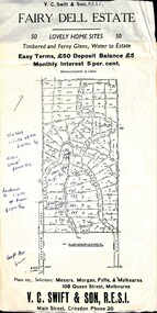
Flyer, Residential Land Sale Sub-division - Fairy Dell Estate, Warranwood, Vic. - circa 1950s
Land sale advertisement for 50 home sites with map of Sub-division showing layout of streets and allotments, summary of local features and services and terms of sale, and copy of sectional map of Crown Allotments 20 & 21B Parish of Warrandyte also showing layout of Sub-division.Subdivision includes Grandview Grove (later Bemboka Road), Merrill Crescent and Kerry Road, Warranwood. Estate Agents - V.C. Swift & Son R.E.S.I., Main Street, Croydon, Phone 20. Solicitors - Morgan, Fyffe & Mulkearns, 108 Queen Street, Melbourne. Handwritten 1970s real estate price notations for some blocks. -
 Ringwood and District Historical Society
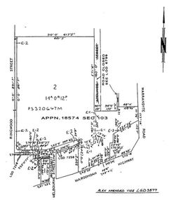
Map, Subdivision Plan - House and 13 residential allotments fronting Fremont Street Ringwood, Vic., and George Street (later Tudor Court), Heathmont, Vic. - Undated, circa 1922
Hand-drawn map on cardboard backing.Formed road with concrete kerbing. Water available to each block. No. of subdivision A139880 73/419. Part of Certificate of Title Vol 5323 Fol 539. Real estate sales notations on some allotments include price. Heading also includes address and phone number of H. Willis, Fremont Street Ringwood - WU6073. -
 Ringwood and District Historical Society
Administrative record - Mining Reports, Government Printer, Melbourne, Colony of Victoria quarterly and annual mining reports - 1860s 1870s & 1880s, 1865 - 1883
Colony of Victoria mining reports show any Ringwood mine references under Castlemaine District, St. Andrews Subdivision. Noteworthy for Ringwood: - Death of Pierce Boardman, mining manager at New Ringwood Mining Co., accidentally killed when he lost his footing and fell to a depth of 40 feet on 1st January 1879. - William White injured in truck accident at New Ringwood Antimony Tribute Company, 31st March 1882.Boxed collection of soft and hard bound reports including: 1. Quarterly Colony of Victoria reports of the Mining Surveyors & Registrars, Victoria, 1865-1881 - Summary of gold mining statistics for the quarter - Tables showing the yield of gold from certain parcels of quartz raised during the quarter in some of the deepest mines in Victoria with depth of the deepest shafts, levels, cross-cuts, etc. - Estimated yield of gold and quantity of gold exported during the quarter - Gold received and issued from the Royal Mint during the quarter - Summary of yield of gold from quartz, tailings, etc., crushed during the quarter - Summary of yield of gold from washdirt and cement washed and crushed during quarter - Number and distribution of miners on the goldfields of the colony. 2. 1879-82 Hard bound volume - Chief Inspector of Mines Reports to the Honorable Minister of Mines, Victoria. (Includes fatal and non-fatal accident reports, mining operations, and employment statistcs.) Noteworthy for Ringwood: - Death of Pierce Boardman, mining manager at New Ringwood Mining Co., accidentally killed when he lost his footing and fell to a depth of 40 feet on 1st January 1879. - William White injured in truck accident at New Ringwood Antimony Tribute Company, 31st March 1882. 3. Mineral Statistics for Victoria - annual reports for years 1867, 1871, 1874, 1876, 1877, 1878, & 1879. 4. Handwritten study notes.antimony, boardman, william white -
Glen Eira Historical Society
Letter - Hopetoun, Hopetoun Street, 2, Elsternwick
A copy of a one page typed letter, from C J and T Ham of the Central Land Office to Florence M Cordner, dated 29/04/1904, providing a valuation of her property located at the corner of Glen Huntly Road and Hopetoun Street, Elsternwick. The valuation provides a description of the land, house improvements and architectural features and outlines possibilities for land subdivision. Noted on the document in pencil is 'From collection of Brighton Historical Society'.cordner florence mrs, glen huntly road, glenhuntly road, elsternwick, hopetoun street, moynsha, melrose, campbell a l, towers, verandahs, brick, stables, ham c j, ham t, c j & t ham, central land office, mansions -
 Greensborough Historical Society
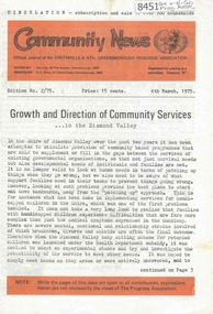
Newsletter, Greenhills and North Greensborough Progress Association, Community News: official journal of the Greenhills and Nth. Greensborough Progress Association. 4th March, 1975. Edition No. 2/75, 04/03/1975
This edition includes a report on the Progress Association's February 1975 meeting, Councillor's report, Growth and direction of community services... in the Diamond Valley, This and that, Public display... outline development plan and subdivision, Diamond Valley Repertory, Kinder news, Re-union... with the Morton family, Scout and Guide news (Scout hall to open), Supplement to "Community News". No. 2/75. Meet the natives. A digital copy of this Newsletter is available from Greensborough Historical Society.Newsletter, 20 p., illus.greenhills and north greensborough progress association, greenhills -
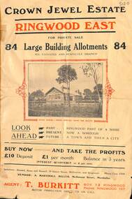 Ringwood and District Historical Society
Flyer, Subdivisional Land Sale Brochure, Crown Jewel Estate, Ringwood East, Vic. - c.1925
In May 1884, George Smart of Bulleen Road Kew, brickmaker, bought the 23 acres one rood and twenty nine and three tenths perches, or 9.4834 hctares from Arthur Bailey Clements of Ringwood for the sum of 600 pound sterling. (Extract from The Story of the Crown Jewel Estate in Ringwood East pdf)Double sided folded page with black and red print on both sides advertising auction sale of residential and business sites and highlighting local facilities, services and layout of the estate.Subdivision includes Mount Dandenong Road, Valda Avenue, Evon Avenue, Mirabel Avenue, and Velma Grove. (Agent) T. Burkitt, Box 12 Ringwood, Phone Ringwood 157. Vendor: A. Marshall Miller, McDonald Street, Mordialloc. Solicitors: Russell, Bona and Russell, 19 Queen Street Melbourne, and Ringwood - Phone Cent. 4308. -
Kew Historical Society Inc
Flyer - 60 Pakington Street, Kew
Subdivision plans and real estate flyers/brochures reveal a number of aspects of urban development and history. The Kew Historical Society's collection of these plans, as well as advertisements extracted from magazines, cover key aspects of community development and architectural history of Kew and Kew Eat as well as surrounding suburbs. While most of the plans in the collection were gifted to the Society by the former City of Kew, a number of other plans and advertisements have been donated by individuals, of which this is an example. Single page illustrated flyer, advertising 60 Pakington Street, Kew for sale. Annotation in pen and ink at right.neville collection, 60 pakington street -- kew (vic.), real estate advertisements -- kew (vic.) -
Kew Historical Society Inc
Flyer - 45 Pakington Street, Kew
Subdivision plans and real estate flyers/brochures reveal a number of aspects of urban development and history. The Kew Historical Society's collection of these plans, as well as advertisements extracted from magazines, cover key aspects of community development and architectural history of Kew and Kew Eat as well as surrounding suburbs. While most of the plans in the collection were gifted to the Society by the former City of Kew, a number of other plans and advertisements have been donated by individuals, of which this is an example.Single page illustrated real estate flyer advertising 45 Pakington Street, Kew for sale by auction. Annotation in pen and ink at rightpeter neville, real estate advertisements -- kew (vic.), 45 pakington street -- kew (vic.) -
Kew Historical Society Inc
Plan - Pointed Firs Estate, Camberwell North, 1936
Subdivision plans and real estate flyers/brochures reveal a number of aspects of urban development and history. The Kew Historical Society's collection of these plans, as well as advertisements extracted from magazines, cover key aspects of community development and architectural history of Kew and Kew Eat as well as surrounding suburbs. While most of the plans in the collection were gifted to the Society by the former City of Kew, a number of other plans and advertisements have been donated by individuals, of which this is an example.Original multi-page sales brochure of the Pointed Firs Estate, advertised as located in Camberwell North, but now in Balwyn North. The 4-page bifold brochure includes promotional material as well as a detailed plan of the 28 lots for sale, a photograph of the locality with the plan overlaying it, as well as aerial photos and street views. The estate included lots in Doncaster Road, Thackeray Street, Houghton Street, an dMaud Street. pointed firs estate -- balwyn north, subdivisions -- balwyn north (vic.) -
Kew Historical Society Inc
Booklet - Yarraleen Estate, Bulleen, c.1966
Subdivision plans and real estate flyers/brochures reveal a number of aspects of urban development and history. The Kew Historical Society's collection of these plans, as well as advertisements extracted from magazines, cover key aspects of community development and architectural history of Kew and Kew Eat as well as surrounding suburbs. While most of the plans in the collection were gifted to the Society by the former City of Kew, a number of other plans and advertisements have been donated by individuals, of which this is an example.Original 8-page booklet advertising a new residential development in Bulleen entitled 'Yarraleen'. The glossy multi-colour brochure includes historic and contemporary photographs of the Yarra Valley, graphic designs of potential residential development, photographs of key facilities (Marcellin College, Golf links, local swimming holes, the Beaver Swim School, Carey Grammar School Oval and grandstand, shopping strips, and farmland).subdivisions -- bulleen (vic.), yarraleen estate -
Kew Historical Society Inc
Plan - 30 Choice Home Sites in Kilby Road, Meldrum Street and Fairway Drive, 1965
Subdivision plans and real estate flyers/brochures reveal a number of aspects of urban development and history. The Kew Historical Society's collection of these plans, as well as advertisements extracted from magazines, cover key aspects of community development and architectural history of Kew and Kew Eat as well as surrounding suburbs. While most of the plans in the collection were gifted to the Society by the former City of Kew, a number of other plans and advertisements have been donated by individuals, of which this is an example.Original 4-page, bifold brochure, one of two in the collection, of home sites created following the creation of the Eastern Freeway which separated a section of land owned by the Kew Golf Club from the main course. The new estate featured 30 lots in Meldrum Street, Kilby Road and Fairway Drive. subdivisions -- kew east (vic.), subdivisions -- kew (vic.), kew golf club